Bridge Statistics for Ethel, Mississippi (MS)
Condition, Traffic, Stress, Structural Evaluation, Project Costs
- National Bridge Inventory (NBI) Statistics
- 25Number of bridges
- 279ft / 84.8mTotal length
- $7,759,000Total costs
- 22,945Total average daily traffic
- 3,050Total average daily truck traffic
- National Bridge Inventory (NBI) Registered Bridges for Ethel
- No street view available for this location
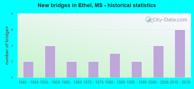
- New bridges - historical statistics
- 21940-1949
- 41950-1959
- 21960-1969
- 21970-1979
- 31980-1989
- 21990-1999
- 42000-2009
- 62010-2019


- Bridge Condition - Deck
- 50.0%Very good
- 31.3%Good
- 18.8%Satisfactory

- Bridge Condition - Superstructure
- 50.0%Very good
- 18.8%Good
- 18.8%Satisfactory
- 12.5%Fair

- Bridge Condition - Substructure
- 43.8%Very good
- 25.0%Good
- 18.8%Satisfactory
- 6.3%Fair
- 6.3%Poor

- Bridge Condition - Channel
- 9.1%Excellent
- 40.9%Very good
- 27.3%Good
- 9.1%Satisfactory
- 9.1%Fair
- 4.5%Poor

- Bridge Condition - Culverts
- 62.5%Very good
- 12.5%Good
- 12.5%Satisfactory
- 12.5%Fair
Find on map >> Show street view
Structure Number: 31000120041046, Location: 4.3 MI E SR 35 SOUTH (Lat: 33.096675, Lng: -89.514861), Route carried "on" structure: State highway 12, Year Built: 2013, Status: Open, Structure Length: 0.98m (3.22ft), Average Daily Traffic: 4,000 (year 2020), Truck Traffic: 12%, Average Future Daily Traffic: 4,000 (year 2040), Design Load: HS 20, Features Intersected: JAYBIRD CREEK
Minimum Vertical Clearance: 30+ m (98+ ft), Kilometerpoint: 34.028, Lanes on structure: 2, Base Highway Network: Yes (Inventory Route: 1, Subroute: 1), Owner: State Highway Agency, Approaching Roadway Width: 8.5m (27.9ft), Skew: 1 degrees, Material/Design: Concrete, Design/Construction: Culvert, Number Of Spans In Main Unit: 2, Length of Maximum Span: 4.9m (16.1ft)
Condition: Channel: Excellent, Culverts: Good, Operating Rating: 54.3 metric tons, Method Used To Determine Operating Rating: Load Factor (LF), Inventory Rating: 32.4 metric tons, Method Used To Determine Inventory Rating: Load Factor (LF), Structural Evaluation: Better than present minimum criteria, Waterway Adequacy: Equal to present desirable criteria, Approach Roadway Alignment: Equal to present desirable criteria, Designated Inspection Frequency: Every 24 months, Inspection Date: October 2021
Find on map >> Show street view
Structure Number: 31000120041074, Location: 6.9 MI E SR 35 SOUTH (Lat: 33.120003, Lng: -89.478225), Route carried "on" structure: State highway 12, Year Built: 2013, Status: Open, Structure Length: 3.71m (12.17ft), Average Daily Traffic: 2,000 (year 2020), Truck Traffic: 14%, Average Future Daily Traffic: 2,000 (year 2040), Design Load: HS 20, Features Intersected: LEFLORE CREEK
Minimum Vertical Clearance: 30+ m (98+ ft), Kilometerpoint: 38.322, Lanes on structure: 2, Base Highway Network: Yes (Inventory Route: 1, Subroute: 1), Owner: State Highway Agency, Approaching Roadway Width: 13.4m (44.0ft), Material/Design: Prestressed concrete continuous, Design/Construction: Stringer/Multi-beam, Number Of Spans In Main Unit: 3, Length of Maximum Span: 12.2m (40.0ft), Curb-To-Curb Width: 13.4m (44.0ft), Out-to-Out Width: 14.3m (46.9ft)
Condition: Deck: Very good, Superstructure: Very good, Substructure: Very good, Channel: Good, Operating Rating: 71.7 metric tons, Method Used To Determine Operating Rating: Load Factor (LF), Inventory Rating: 38.7 metric tons, Method Used To Determine Inventory Rating: Load Factor (LF), Structural Evaluation: Equal to present desirable criteria, Deck Geometry: Equal to present desirable criteria, Waterway Adequacy: Superior to present desirable criteria, Approach Roadway Alignment: Equal to present desirable criteria, Designated Inspection Frequency: Every 24 months, Inspection Date: October 2021, Deck Structure Type: Concrete Cast-file-Place
Find on map >> Show street view
Structure Number: 31000120041102, Location: 9.8 MI E SR 35 SOUTH (Lat: 33.147850, Lng: -89.448108), Route carried "on" structure: State highway 12, Year Built: 2013, Status: Open, Structure Length: 7.36m (24.15ft), Average Daily Traffic: 1,700 (year 2020), Truck Traffic: 14%, Average Future Daily Traffic: 1,700 (year 2040), Design Load: HS 20, Features Intersected: COLE CREEK TRIBUTARY
Minimum Vertical Clearance: 30+ m (98+ ft), Kilometerpoint: 42.533, Lanes on structure: 2, Base Highway Network: Yes (Inventory Route: 1, Subroute: 1), Owner: State Highway Agency, Approaching Roadway Width: 13.4m (44.0ft), Material/Design: Prestressed concrete continuous, Design/Construction: Stringer/Multi-beam, Number Of Spans In Main Unit: 6, Length of Maximum Span: 12.2m (40.0ft), Curb-To-Curb Width: 13.4m (44.0ft), Out-to-Out Width: 14.3m (46.9ft)
Condition: Deck: Very good, Superstructure: Very good, Substructure: Very good, Channel: Excellent, Operating Rating: 71.7 metric tons, Method Used To Determine Operating Rating: Load Factor (LF), Inventory Rating: 38.7 metric tons, Method Used To Determine Inventory Rating: Load Factor (LF), Structural Evaluation: Equal to present desirable criteria, Deck Geometry: Equal to present desirable criteria, Waterway Adequacy: Superior to present desirable criteria, Approach Roadway Alignment: Equal to present desirable criteria, Designated Inspection Frequency: Every 24 months, Inspection Date: October 2021, Deck Structure Type: Concrete Cast-file-Place
Find on map >> Show street view
Structure Number: 31000120041105, Location: 10.1 MI E SR 35 SOUTH (Lat: 33.152322, Lng: -89.444250), Route carried "on" structure: State highway 12, Year Built: 2013, Status: Open, Structure Length: 6.75m (22.15ft), Average Daily Traffic: 1,700 (year 2020), Truck Traffic: 14%, Average Future Daily Traffic: 1,700 (year 2040), Design Load: HS 20, Features Intersected: COLE CREEK
Minimum Vertical Clearance: 30+ m (98+ ft), Kilometerpoint: 43.145, Lanes on structure: 2, Base Highway Network: Yes (Inventory Route: 1, Subroute: 1), Owner: State Highway Agency, Approaching Roadway Width: 13.4m (44.0ft), Material/Design: Prestressed concrete, Design/Construction: Stringer/Multi-beam, Number Of Spans In Main Unit: 1, Number Of Approach Spans: 4, Length of Maximum Span: 18.3m (60.0ft), Curb-To-Curb Width: 13.4m (44.0ft), Out-to-Out Width: 14.3m (46.9ft)
Condition: Deck: Very good, Superstructure: Very good, Substructure: Very good, Channel: Good, Operating Rating: 74.0 metric tons, Method Used To Determine Operating Rating: Load Factor (LF), Inventory Rating: 38.7 metric tons, Method Used To Determine Inventory Rating: Load Factor (LF), Structural Evaluation: Equal to present desirable criteria, Deck Geometry: Equal to present desirable criteria, Waterway Adequacy: Superior to present desirable criteria, Approach Roadway Alignment: Equal to present desirable criteria, Designated Inspection Frequency: Every 24 months, Inspection Date: October 2021, Deck Structure Type: Concrete Cast-file-Place
Find on map >> Show street view
Structure Number: 36000120041074, Location: 0.5 MI E SR 12 (Lat: 33.116292, Lng: -89.475183), Route carried "on" structure: State highway 739, Year Built: 1986, Status: Open, Structure Length: 3.26m (10.70ft), Average Daily Traffic: 1,100 (year 2020), Truck Traffic: 11%, Average Future Daily Traffic: 1,100 (year 2040), Design Load: HS 20, Features Intersected: CREEK
Minimum Vertical Clearance: 30+ m (98+ ft), Kilometerpoint: 0.874, Lanes on structure: 2, Owner: State Highway Agency, Approaching Roadway Width: 8.5m (27.9ft), Material/Design: Concrete, Design/Construction: Channel Beam, Number Of Spans In Main Unit: 1, Number Of Approach Spans: 4, Length of Maximum Span: 9.4m (30.8ft), Curb-To-Curb Width: 8.5m (27.9ft), Out-to-Out Width: 8.5m (27.9ft)
Condition: Deck: Good, Superstructure: Good, Substructure: Good, Channel: Very good, Operating Rating: 75.5 metric tons, Method Used To Determine Operating Rating: Load Factor (LF), Inventory Rating: 45.3 metric tons, Method Used To Determine Inventory Rating: Load Factor (LF), Structural Evaluation: Better than present minimum criteria, Deck Geometry: Somewhat better than minimum adequacy, Waterway Adequacy: Equal to present desirable criteria, Approach Roadway Alignment: Equal to present desirable criteria, Designated Inspection Frequency: Every 24 months, Inspection Date: August 2020, Deck Structure Type: Concrete Precast Panels
Find on map >> Show street view
Structure Number: 5570107P, Location: 4.0 MILES NORTH OF MS ROU (Lat: 33.149611, Lng: -89.478722), Route carried "on" structure: Federal lands road 1, Year Built: 1964, Status: Posted for load-capacity, Structure Length: 0.93m (3.05ft), Average Daily Traffic: 1,140 (year 2012), Truck Traffic: 11%, Average Future Daily Traffic: 1,254 (year 2032), Design Load: H 15, Features Intersected: COUNTY ROAD, Facility Carried by Structure: NATCHEZ TRACE PARK
Minimum Vertical Clearance: 30+ m (98+ ft), Kilometerpoint: 273.080, Lanes on structure: 2, Lanes under structure: 2, Owner: National Park Service, Approaching Roadway Width: 9.7m (31.8ft), Skew: 1 degrees, Material/Design: Concrete, Design/Construction: Frame, Number Of Spans In Main Unit: 1, Length of Maximum Span: 9.3m (30.5ft), Curb or Sidewalk Widths: Left: 0.4m (1.3ft), Right: 0.4m (1.3ft), Curb-To-Curb Width: 8.7m (28.5ft), Out-to-Out Width: 10.0m (32.8ft)
Condition: Deck: Good, Superstructure: Good, Substructure: Good, Inventory Rating: 75.3 metric tons, Method Used To Determine Inventory Rating: Load Factor (LF), Structural Evaluation: Better than present minimum criteria, Deck Geometry: Somewhat better than minimum adequacy, Underclear: High priority of corrective action, Approach Roadway Alignment: Equal to present desirable criteria, Designated Inspection Frequency: Every 48 months, Inspection Date: November 2018, Deck Structure Type: Concrete Cast-file-Place, Wearing Surface/Protective System: Wearing Surface: Bituminous
Find on map >> Show street view
Structure Number: 5570110P, Location: 5.1 MILES NORTH OF MS ROU (Lat: 33.161556, Lng: -89.467833), Route carried "on" structure: Federal lands road 1, Year Built: 1942, Status: Posted for load-capacity, Structure Length: 6.10m (20.01ft), Average Daily Traffic: 1,140 (year 2012), Truck Traffic: 11%, Average Future Daily Traffic: 1,254 (year 2032), Design Load: H 15, Features Intersected: BLACK CREEK, Facility Carried by Structure: NATCHEZ TRACE PARK
Minimum Vertical Clearance: 30+ m (98+ ft), Kilometerpoint: 274.840, Lanes on structure: 2, Owner: National Park Service, Approaching Roadway Width: 9.7m (31.8ft), Material/Design: Concrete continuous, Design/Construction: Slab, Number Of Spans In Main Unit: 6, Length of Maximum Span: 11.0m (36.1ft), Curb-To-Curb Width: 9.1m (29.9ft), Out-to-Out Width: 10.4m (34.1ft)
Condition: Deck: Good, Superstructure: Good, Substructure: Satisfactory, Channel: Good, Operating Rating: 45.4 metric tons, Method Used To Determine Operating Rating: Load Factor (LF), Inventory Rating: 27.2 metric tons, Method Used To Determine Inventory Rating: Load Factor (LF), Structural Evaluation: Equal to present minimum criteria, Deck Geometry: Somewhat better than minimum adequacy, Waterway Adequacy: Equal to present desirable criteria, Approach Roadway Alignment: Equal to present desirable criteria, Designated Inspection Frequency: Every 48 months, Inspection Date: December 2018, Deck Structure Type: Concrete Cast-file-Place, Wearing Surface/Protective System: Wearing Surface: Bituminous
Find on map >> Show street view
Structure Number: 5570111P, Location: 5.8 MILES NORTH OF MS ROU (Lat: 33.097306, Lng: -89.513361), Route carried "on" structure: Federal lands road 1, Year Built: 1950, Status: Posted for load-capacity, Structure Length: 2.13m (6.99ft), Average Daily Traffic: 1,430 (year 2012), Truck Traffic: 14%, Average Future Daily Traffic: 1,573 (year 2032), Design Load: H 15, Features Intersected: MS ROUTE 12, Facility Carried by Structure: NATCHEZ TRACE PARK
Minimum Vertical Clearance: 30+ m (98+ ft), Kilometerpoint: 266.652, Lanes on structure: 2, Lanes under structure: 2, Owner: National Park Service, Approaching Roadway Width: 8.5m (27.9ft), Skew: 5 degrees, Material/Design: Concrete, Design/Construction: Frame, Number Of Spans In Main Unit: 1, Length of Maximum Span: 21.3m (69.9ft), Curb-To-Curb Width: 8.5m (27.9ft), Out-to-Out Width: 9.9m (32.5ft)
Condition: Deck: Satisfactory, Superstructure: Satisfactory, Substructure: Good, Operating Rating: 27.2 metric tons, Method Used To Determine Operating Rating: Load Factor (LF), Inventory Rating: 16.3 metric tons, Method Used To Determine Inventory Rating: Load Factor (LF), Structural Evaluation: Meets minimum limits, Deck Geometry: Somewhat better than minimum adequacy, Underclear: Meets minimum limits, Approach Roadway Alignment: Equal to present desirable criteria, Designated Inspection Frequency: Every 24 months, Inspection Date: October 2020, Bridge Improvement Cost: $36,000, Roadway Improvement Cost: $4,000, Total Project Cost: $54,000 ( Estimate for 2018), Deck Structure Type: Concrete Cast-file-Place, Wearing Surface/Protective System: Wearing Surface: Bituminous
Find on map >> Show street view
Structure Number: 5570204P, Location: 0.1 MILES SOUTH OF MS ROU (Lat: 33.095611, Lng: -89.514333), Route carried "on" structure: Federal lands road 1, Year Built: 1950, Status: Posted for load-capacity, Structure Length: 1.58m (5.18ft), Average Daily Traffic: 1,430 (year 2012), Truck Traffic: 14%, Average Future Daily Traffic: 1,573 (year 2032), Features Intersected: JAYBIRD CREEK, Facility Carried by Structure: NATCHEZ TRACE PARK
Minimum Vertical Clearance: 30+ m (98+ ft), Kilometerpoint: 266.266, Lanes on structure: 2, Owner: National Park Service, Approaching Roadway Width: 9.8m (32.2ft), Skew: 4 degrees, Material/Design: Concrete, Design/Construction: Culvert, Number Of Spans In Main Unit: 3, Length of Maximum Span: 5.4m (17.7ft)
Condition: Channel: Fair, Culverts: Fair, Structural Evaluation: Somewhat better than minimum adequacy, Waterway Adequacy: Somewhat better than minimum adequacy, Approach Roadway Alignment: Equal to present desirable criteria, Designated Inspection Frequency: Every 24 months, Inspection Date: October 2020, Bridge Improvement Cost: $350,000, Roadway Improvement Cost: $35,000, Total Project Cost: $525,000 ( Estimate for 2018)
Find on map >> Show street view
Structure Number: 5570349P, Location: 3.1 MILES NORTH OF MS ROU (Lat: 33.137444, Lng: -89.486750), Route carried "on" structure: Federal lands road 1, Year Built: 1950, Status: Posted for load-capacity, Structure Length: 1.11m (3.64ft), Average Daily Traffic: 1,140 (year 2012), Truck Traffic: 11%, Average Future Daily Traffic: 1,254 (year 2032), Features Intersected: STREAM, Facility Carried by Structure: NATCHEZ TRACE PARK
Minimum Vertical Clearance: 30+ m (98+ ft), Kilometerpoint: 271.650, Lanes on structure: 2, Owner: National Park Service, Approaching Roadway Width: 9.7m (31.8ft), Skew: 4 degrees, Material/Design: Concrete, Design/Construction: Culvert, Number Of Spans In Main Unit: 3, Length of Maximum Span: 3.8m (12.5ft)
Condition: Channel: Satisfactory, Culverts: Satisfactory, Operating Rating: 40.8 metric tons, Method Used To Determine Operating Rating: Field evaluation and documented engineering judgment, Inventory Rating: 24.5 metric tons, Method Used To Determine Inventory Rating: Field evaluation and documented engineering judgment, Structural Evaluation: Equal to present minimum criteria, Waterway Adequacy: Equal to present desirable criteria, Approach Roadway Alignment: Equal to present desirable criteria, Designated Inspection Frequency: Every 48 months, Inspection Date: November 2018, Bridge Improvement Cost: $25,000, Roadway Improvement Cost: $3,000, Total Project Cost: $38,000 ( Estimate for 2018)
Find on map >> Show street view
Structure Number: SA0400000000079, Location: SEC 2 T14N R 8E B (Lat: 33.097222, Lng: -89.456667), Route carried "on" structure: County highway 412, Year Built: 2008, Status: Open, Structure Length: 4.00m (13.12ft), Average Daily Traffic: 275 (year 2007), Truck Traffic: 8%, Average Future Daily Traffic: 345 (year 2030), Design Load: HS 20, Features Intersected: BCH YOCKANOOKANY RIVER, Facility Carried by Structure: CO. ROAD 5053
Minimum Vertical Clearance: 30+ m (98+ ft), Kilometerpoint: 8.046, Lanes on structure: 2, Owner: County Highway Agency, Approaching Roadway Width: 9.1m (29.9ft), Skew: 3 degrees, Material/Design: Concrete, Design/Construction: Channel Beam, Number Of Spans In Main Unit: 5, Length of Maximum Span: 9.4m (30.8ft), Curb or Sidewalk Widths: Left: 0.4m (1.3ft), Right: 0.4m (1.3ft), Curb-To-Curb Width: 8.5m (27.9ft), Out-to-Out Width: 9.3m (30.5ft)
Condition: Deck: Very good, Superstructure: Very good, Substructure: Very good, Channel: Very good, Operating Rating: 62.5 metric tons, Method Used To Determine Operating Rating: Load Factor (LF) rating reported by rating factor (RF) method using MS18 loading, Inventory Rating: 37.6 metric tons, Method Used To Determine Inventory Rating: Load Factor (LF) rating reported by rating factor (RF) method using MS18 loading, Structural Evaluation: Equal to present desirable criteria, Deck Geometry: Equal to present minimum criteria, Waterway Adequacy: Equal to present desirable criteria, Approach Roadway Alignment: Equal to present desirable criteria, Designated Inspection Frequency: Every 24 months, Inspection Date: Febuary 2021, Bridge Improvement Cost: $595,000, Roadway Improvement Cost: $100,000, Total Project Cost: $695,000 ( Estimate for 2019), Deck Structure Type: Concrete Precast Panels, Wearing Surface/Protective System: Wearing Surface: Monolithic Concrete
Find on map >> Show street view
Structure Number: SA040000000008, Location: SEC 2 T14N R 8E B (Lat: 33.098572, Lng: -89.457092), Route carried "on" structure: County highway 412, Year Built: 2008, Status: Open, Structure Length: 2.68m (8.79ft), Average Daily Traffic: 275 (year 2013), Truck Traffic: 8%, Average Future Daily Traffic: 345 (year 2035), Design Load: HS 20, Features Intersected: YOCKANOOKANY BCH RELIEF, Facility Carried by Structure: CO. ROAD 5053
Minimum Vertical Clearance: 30+ m (98+ ft), Kilometerpoint: 8.207, Lanes on structure: 2, Owner: County Highway Agency, Approaching Roadway Width: 9.1m (29.9ft), Material/Design: Concrete, Design/Construction: Channel Beam, Number Of Spans In Main Unit: 4, Length of Maximum Span: 9.4m (30.8ft), Curb or Sidewalk Widths: Left: 0.4m (1.3ft), Right: 0.4m (1.3ft), Curb-To-Curb Width: 8.5m (27.9ft), Out-to-Out Width: 9.3m (30.5ft)
Condition: Deck: Very good, Superstructure: Very good, Substructure: Very good, Channel: Very good, Operating Rating: 59.3 metric tons, Method Used To Determine Operating Rating: Load Factor (LF) rating reported by rating factor (RF) method using MS18 loading, Inventory Rating: 35.3 metric tons, Method Used To Determine Inventory Rating: Load Factor (LF) rating reported by rating factor (RF) method using MS18 loading, Structural Evaluation: Equal to present desirable criteria, Deck Geometry: Equal to present minimum criteria, Waterway Adequacy: Equal to present desirable criteria, Approach Roadway Alignment: Equal to present desirable criteria, Length Of Structure Improvement: 3.90m (12.80ft), Designated Inspection Frequency: Every 24 months, Inspection Date: April 2020, Bridge Improvement Cost: $448,000, Roadway Improvement Cost: $100,000, Total Project Cost: $558,000 ( Estimate for 2020), Deck Structure Type: Concrete Precast Panels, Wearing Surface/Protective System: Wearing Surface: Monolithic Concrete
Find on map >> Show street view
Structure Number: SA0400000000082, Location: SEC 11 T14N R 8E (Lat: 33.092236, Lng: -89.452286), Route carried "on" structure: County highway 291, Year Built: 1994, Status: Posted for load, Structure Length: 2.70m (8.86ft), Average Daily Traffic: 50 (year 2021), Average Future Daily Traffic: 75 (year 2041), Design Load: H 15, Features Intersected: BCH YOCKANOOKANY RIVER, Facility Carried by Structure: CO. ROAD 5210
Minimum Vertical Clearance: 30+ m (98+ ft), Kilometerpoint: 4.506, Lanes on structure: 2, Owner: County Highway Agency, Approaching Roadway Width: 6.1m (20.0ft), Material/Design: Steel, Number Of Spans In Main Unit: 1, Length of Maximum Span: 21.3m (69.9ft), Curb-To-Curb Width: 5.5m (18.0ft), Out-to-Out Width: 5.5m (18.0ft)
Condition: Deck: Satisfactory, Superstructure: Satisfactory, Substructure: Satisfactory, Channel: Satisfactory, Operating Rating: 19.3 metric tons, Method Used To Determine Operating Rating: Load Factor (LF), Inventory Rating: 11.8 metric tons, Method Used To Determine Inventory Rating: Load Factor (LF), Structural Evaluation: Meets minimum limits, Deck Geometry: Meets minimum limits, Waterway Adequacy: Better than present minimum criteria, Approach Roadway Alignment: Equal to present minimum criteria, Bridge Posting: Required (Relationship of Operating Rating to Maximum Legal Load: > 39.9% below), Length Of Structure Improvement: 2.90m (9.51ft), Designated Inspection Frequency: Every 24 months, Critical Feature Inspection Frequency: Every 24 months, Inspection Date: December 2020, Critical Feature Inspection Date: December 2020, Bridge Improvement Cost: $104,000, Roadway Improvement Cost: $20,000, Total Project Cost: $138,000, Deck Structure Type: Wood or Timber, Wearing Surface/Protective System: Wearing Surface: Gravel
Find on map >> Show street view
Structure Number: SA0400000000083, Location: SEC 11 T14N R 8E B (Lat: 33.082653, Lng: -89.441892), Route carried "on" structure: County highway 412, Year Built: 1966, Status: Open, Structure Length: 0.67m (2.20ft), Average Daily Traffic: 230 (year 2013), Truck Traffic: 8%, Average Future Daily Traffic: 345 (year 2035), Design Load: HS 15, Features Intersected: BCH YOCKANOOKANY RIVER, Facility Carried by Structure: CO. ROAD 5053
Minimum Vertical Clearance: 30+ m (98+ ft), Kilometerpoint: 5.632, Lanes on structure: 2, Owner: County Highway Agency, Approaching Roadway Width: 7.3m (24.0ft), Material/Design: Concrete, Design/Construction: Culvert, Number Of Spans In Main Unit: 1, Length of Maximum Span: 6.1m (20.0ft)
Condition: Channel: Fair, Culverts: Very good, Operating Rating: 57.0 metric tons, Method Used To Determine Operating Rating: Load Factor (LF) rating reported by rating factor (RF) method using MS18 loading, Inventory Rating: 34.3 metric tons, Method Used To Determine Inventory Rating: Load Factor (LF) rating reported by rating factor (RF) method using MS18 loading, Structural Evaluation: Equal to present desirable criteria, Waterway Adequacy: Better than present minimum criteria, Approach Roadway Alignment: Equal to present minimum criteria, Length Of Structure Improvement: 0.67m (2.20ft), Designated Inspection Frequency: Every 24 months, Inspection Date: April 2020, Bridge Improvement Cost: $250,000, Roadway Improvement Cost: $100,000, Total Project Cost: $350,000 ( Estimate for 2020)
Find on map >> Show street view
Structure Number: SA0400000000084, Location: SEC 12 T14N R 8E (Lat: 33.084722, Lng: -89.427500), Route carried "on" structure: County highway 292, Year Built: 2005, Status: Open, Structure Length: 0.70m (2.30ft), Average Daily Traffic: 60 (year 2013), Truck Traffic: 8%, Average Future Daily Traffic: 90 (year 2035), Design Load: HS 20, Features Intersected: BCH YOCKANOOKANY RIVER, Facility Carried by Structure: CO. ROAD 5217
Minimum Vertical Clearance: 30+ m (98+ ft), Kilometerpoint: 0.804, Lanes on structure: 2, Owner: County Highway Agency, Approaching Roadway Width: 6.1m (20.0ft), Skew: 3 degrees, Material/Design: Concrete, Design/Construction: Culvert, Number Of Spans In Main Unit: 1, Length of Maximum Span: 6.3m (20.7ft)
Condition: Channel: Very good, Culverts: Very good, Operating Rating: 45.0 metric tons, Method Used To Determine Operating Rating: Load Factor (LF) rating reported by rating factor (RF) method using MS18 loading, Inventory Rating: 27.5 metric tons, Method Used To Determine Inventory Rating: Load Factor (LF) rating reported by rating factor (RF) method using MS18 loading, Structural Evaluation: Equal to present minimum criteria, Waterway Adequacy: Equal to present desirable criteria, Approach Roadway Alignment: Equal to present desirable criteria, Length Of Structure Improvement: 0.70m (2.30ft), Designated Inspection Frequency: Every 24 months, Inspection Date: April 2020, Bridge Improvement Cost: $250,000, Roadway Improvement Cost: $100,000, Total Project Cost: $350,000 ( Estimate for 2020)
Find on map >> Show street view
Structure Number: SA0400000000085, Location: SEC 12 T14N R 8E (Lat: 33.087500, Lng: -89.427500), Route carried "on" structure: County highway 292, Year Built: 2005, Status: Open, Structure Length: 0.94m (3.08ft), Average Daily Traffic: 60 (year 2013), Truck Traffic: 8%, Average Future Daily Traffic: 90 (year 2035), Design Load: HS 20, Features Intersected: BCH YOCKANOOKANY RIVER, Facility Carried by Structure: CO. ROAD 5217
Minimum Vertical Clearance: 30+ m (98+ ft), Kilometerpoint: 0.804, Lanes on structure: 2, Owner: County Highway Agency, Approaching Roadway Width: 6.1m (20.0ft), Material/Design: Concrete, Design/Construction: Culvert, Number Of Spans In Main Unit: 2, Length of Maximum Span: 4.3m (14.1ft)
Condition: Channel: Very good, Culverts: Very good, Operating Rating: 54.1 metric tons, Method Used To Determine Operating Rating: Load Factor (LF) rating reported by rating factor (RF) method using MS18 loading, Inventory Rating: 32.4 metric tons, Method Used To Determine Inventory Rating: Load Factor (LF) rating reported by rating factor (RF) method using MS18 loading, Structural Evaluation: Equal to present desirable criteria, Waterway Adequacy: Equal to present desirable criteria, Approach Roadway Alignment: Equal to present desirable criteria, Length Of Structure Improvement: 0.94m (3.08ft), Designated Inspection Frequency: Every 24 months, Inspection Date: April 2020, Bridge Improvement Cost: $250,000, Roadway Improvement Cost: $100,000, Total Project Cost: $350,000 ( Estimate for 2020)
Find on map >> Show street view
Structure Number: SA0400000000115, Location: SEC 8 T15N R 8E (Lat: 33.166667, Lng: -89.491667), Route carried "on" structure: County highway 212, Year Built: 1998, Status: Open, Structure Length: 1.28m (4.20ft), Average Daily Traffic: 50 (year 2013), Truck Traffic: 8%, Average Future Daily Traffic: 75 (year 2033), Design Load: HS 20+Mod, Features Intersected: BCH YOCKANOOKANY RIVER, Facility Carried by Structure: CO. ROAD 2235
Minimum Vertical Clearance: 30+ m (98+ ft), Kilometerpoint: 0.804, Lanes on structure: 2, Owner: County Highway Agency, Approaching Roadway Width: 6.1m (20.0ft), Material/Design: Concrete, Design/Construction: Culvert, Number Of Spans In Main Unit: 1, Length of Maximum Span: 6.1m (20.0ft)
Condition: Channel: Very good, Culverts: Very good, Operating Rating: 52.8 metric tons, Method Used To Determine Operating Rating: Load Factor (LF) rating reported by rating factor (RF) method using MS18 loading, Inventory Rating: 31.4 metric tons, Method Used To Determine Inventory Rating: Load Factor (LF) rating reported by rating factor (RF) method using MS18 loading, Structural Evaluation: Better than present minimum criteria, Waterway Adequacy: Somewhat better than minimum adequacy, Approach Roadway Alignment: Equal to present desirable criteria, Length Of Structure Improvement: 1.21m (3.97ft), Designated Inspection Frequency: Every 24 months, Inspection Date: April 2020, Bridge Improvement Cost: $250,000, Roadway Improvement Cost: $100,000, Total Project Cost: $350,000 ( Estimate for 2020)
Find on map >> Show street view
Structure Number: SA0400000000117, Location: SEC 15 T15N R 8E B (Lat: 33.162164, Lng: -89.472181), Route carried "on" structure: County highway 408, Year Built: 1974, Status: Posted for load, Structure Length: 3.47m (11.38ft), Average Daily Traffic: 100 (year 2013), Average Future Daily Traffic: 150 (year 2033), Design Load: H 15, Features Intersected: BCH YOCKANOOKANY RIVER, Facility Carried by Structure: CO. ROAD 2247
Minimum Vertical Clearance: 30+ m (98+ ft), Kilometerpoint: 14.966, Lanes on structure: 2, Owner: County Highway Agency, Approaching Roadway Width: 7.3m (24.0ft), Material/Design: Concrete, Design/Construction: Channel Beam, Number Of Spans In Main Unit: 6, Length of Maximum Span: 5.8m (19.0ft), Curb or Sidewalk Widths: Left: 0.2m (0.7ft), Right: 0.2m (0.7ft), Curb-To-Curb Width: 8.2m (26.9ft), Out-to-Out Width: 8.7m (28.5ft)
Condition: Deck: Satisfactory, Superstructure: Fair, Substructure: Poor, Channel: Good, Operating Rating: 61.2 metric tons, Method Used To Determine Operating Rating: Load Factor (LF) rating reported by rating factor (RF) method using MS18 loading, Inventory Rating: 36.6 metric tons, Method Used To Determine Inventory Rating: Load Factor (LF) rating reported by rating factor (RF) method using MS18 loading, Structural Evaluation: Meets minimum limits, Deck Geometry: Equal to present minimum criteria, Waterway Adequacy: Better than present minimum criteria, Approach Roadway Alignment: Equal to present desirable criteria, Bridge Posting: Required (Relationship of Operating Rating to Maximum Legal Load: > 39.9% below), Length Of Structure Improvement: 3.47m (11.38ft), Designated Inspection Frequency: Every 12 months, Inspection Date: November 2021, Bridge Improvement Cost: $124,000, Roadway Improvement Cost: $20,000, Total Project Cost: $160,000, Deck Structure Type: Concrete Precast Panels, Wearing Surface/Protective System: Wearing Surface: Monolithic Concrete
Find on map >> Show street view
Structure Number: SA0400000000119, Location: SEC 34 T15N R 8E B (Lat: 33.110833, Lng: -89.461944), Route carried "on" structure: County highway 412, Year Built: 1980, Status: Open, Structure Length: 6.10m (20.01ft), Average Daily Traffic: 275 (year 2013), Truck Traffic: 8%, Average Future Daily Traffic: 345 (year 2030), Design Load: HS 15, Features Intersected: YOCKANOOKANY RIVER, Facility Carried by Structure: CO. ROAD 5053
Minimum Vertical Clearance: 30+ m (98+ ft), Kilometerpoint: 9.816, Lanes on structure: 2, Owner: County Highway Agency, Approaching Roadway Width: 7.3m (24.0ft), Material/Design: Prestressed concrete, Design/Construction: Stringer/Multi-beam, Number Of Spans In Main Unit: 4, Length of Maximum Span: 24.4m (80.1ft), Curb or Sidewalk Widths: Left: 0.1m (0.3ft), Right: 0.1m (0.3ft), Curb-To-Curb Width: 7.9m (25.9ft), Out-to-Out Width: 8.8m (28.9ft)
Condition: Deck: Very good, Superstructure: Very good, Substructure: Good, Channel: Poor, Operating Rating: 32.4 metric tons, Method Used To Determine Operating Rating: Allowable Stress (AS), Inventory Rating: 24.3 metric tons, Method Used To Determine Inventory Rating: Allowable Stress (AS), Structural Evaluation: Equal to present minimum criteria, Deck Geometry: Somewhat better than minimum adequacy, Waterway Adequacy: Equal to present desirable criteria, Approach Roadway Alignment: Equal to present minimum criteria, Length Of Structure Improvement: 6.10m (20.01ft), Designated Inspection Frequency: Every 24 months, Inspection Date: April 2020, Bridge Improvement Cost: $700,000, Roadway Improvement Cost: $100,000, Total Project Cost: $800,000 ( Estimate for 2020), Deck Structure Type: Concrete Cast-file-Place, Wearing Surface/Protective System: Wearing Surface: Monolithic Concrete
Find on map >> Show street view
Structure Number: SA040000000012, Location: SEC 34 T15N R 8E B (Lat: 33.112125, Lng: -89.463311), Route carried "on" structure: County highway 412, Year Built: 1956, Status: Open, Structure Length: 8.69m (28.51ft), Average Daily Traffic: 230 (year 2013), Truck Traffic: 8%, Average Future Daily Traffic: 345 (year 2030), Design Load: H 15, Features Intersected: RELIEF FOR YOCKANOOKANY, Facility Carried by Structure: CO. ROAD 5053
Minimum Vertical Clearance: 30+ m (98+ ft), Kilometerpoint: 9.977, Lanes on structure: 2, Owner: County Highway Agency, Approaching Roadway Width: 7.3m (24.0ft), Material/Design: Concrete, Design/Construction: Slab, Number Of Spans In Main Unit: 15, Length of Maximum Span: 5.8m (19.0ft), Curb or Sidewalk Widths: Left: 0.4m (1.3ft), Right: 0.4m (1.3ft), Curb-To-Curb Width: 6.7m (22.0ft), Out-to-Out Width: 7.5m (24.6ft)
Condition: Deck: Good, Superstructure: Fair, Substructure: Satisfactory, Channel: Good, Operating Rating: 33.7 metric tons, Method Used To Determine Operating Rating: Load Factor (LF) rating reported by rating factor (RF) method using MS18 loading, Inventory Rating: 20.1 metric tons, Method Used To Determine Inventory Rating: Load Factor (LF) rating reported by rating factor (RF) method using MS18 loading, Structural Evaluation: Somewhat better than minimum adequacy, Deck Geometry: Meets minimum limits, Waterway Adequacy: Equal to present minimum criteria, Approach Roadway Alignment: Equal to present minimum criteria, Length Of Structure Improvement: 8.69m (28.51ft), Designated Inspection Frequency: Every 24 months, Inspection Date: April 2020, Bridge Improvement Cost: $998,000, Roadway Improvement Cost: $100,000, Total Project Cost: $1,098,000 ( Estimate for 2020), Deck Structure Type: Concrete Cast-file-Place, Wearing Surface/Protective System: Wearing Surface: Monolithic Concrete
Find on map >> Show street view
Structure Number: SA0400000000122, Location: SEC 35 T15N R 8E B (Lat: 33.123178, Lng: -89.452922), Route carried "on" structure: County highway 685, Year Built: 1987, Status: Open, Structure Length: 8.53m (27.99ft), Average Daily Traffic: 390 (year 2013), Truck Traffic: 8%, Average Future Daily Traffic: 585 (year 2035), Design Load: HS 20, Features Intersected: YOCKANOOKANY CANAL, Facility Carried by Structure: HANNAH ST.
Minimum Vertical Clearance: 30+ m (98+ ft), Kilometerpoint: 1.126, Lanes on structure: 2, Owner: County Highway Agency, Approaching Roadway Width: 7.9m (25.9ft), Material/Design: Prestressed concrete, Design/Construction: Stringer/Multi-beam, Number Of Spans In Main Unit: 6, Length of Maximum Span: 24.4m (80.1ft), Curb or Sidewalk Widths: Left: 0.2m (0.7ft), Right: 0.2m (0.7ft), Curb-To-Curb Width: 8.5m (27.9ft), Out-to-Out Width: 9.4m (30.8ft)
Condition: Deck: Very good, Superstructure: Very good, Substructure: Very good, Channel: Very good, Operating Rating: 61.2 metric tons, Method Used To Determine Operating Rating: Load Factor (LF) rating reported by rating factor (RF) method using MS18 loading, Inventory Rating: 33.7 metric tons, Method Used To Determine Inventory Rating: Load Factor (LF) rating reported by rating factor (RF) method using MS18 loading, Structural Evaluation: Equal to present desirable criteria, Deck Geometry: Equal to present minimum criteria, Waterway Adequacy: Equal to present desirable criteria, Approach Roadway Alignment: Better than present minimum criteria, Length Of Structure Improvement: 3.66m (12.01ft), Designated Inspection Frequency: Every 24 months, Inspection Date: April 2020, Bridge Improvement Cost: $421,000, Roadway Improvement Cost: $100,000, Total Project Cost: $521,000 ( Estimate for 2020), Deck Structure Type: Concrete Cast-file-Place, Wearing Surface/Protective System: Wearing Surface: Monolithic Concrete
Find on map >> Show street view
Structure Number: SA0400000000173, Location: SEC 10 T14N R 8E (Lat: 33.092917, Lng: -89.457333), Route carried "on" structure: County highway 173, Year Built: 1970, Status: Closed, Structure Length: 1.74m (5.71ft), Average Daily Traffic: 50 (year 2013), Average Future Daily Traffic: 60 (year 2035), Design Load: H 15, Features Intersected: YOCKANOOKANY BCH RELIEF, Facility Carried by Structure: CO. RD. 5120
Minimum Vertical Clearance: 30+ m (98+ ft), Kilometerpoint: 7.036, Lanes on structure: 2, Owner: County Highway Agency, Approaching Roadway Width: 7.3m (24.0ft), Material/Design: Concrete, Design/Construction: Channel Beam, Number Of Spans In Main Unit: 3, Length of Maximum Span: 5.8m (19.0ft), Curb or Sidewalk Widths: Left: 0.4m (1.3ft), Right: 0.4m (1.3ft), Curb-To-Curb Width: 6.7m (22.0ft), Out-to-Out Width: 7.5m (24.6ft)
Condition: Deck: Good, Superstructure: Satisfactory, Substructure: Fair, Channel: Good, Deck Geometry: Somewhat better than minimum adequacy, Waterway Adequacy: Somewhat better than minimum adequacy, Approach Roadway Alignment: Equal to present minimum criteria, Bridge Posting: Required (Relationship of Operating Rating to Maximum Legal Load: > 39.9% below), Length Of Structure Improvement: 2.32m (7.61ft), Designated Inspection Frequency: Every 24 months, Inspection Date: November 2021, Bridge Improvement Cost: $114,000, Roadway Improvement Cost: $75,000, Total Project Cost: $189,000, Deck Structure Type: Concrete Precast Panels, Wearing Surface/Protective System: Wearing Surface: Monolithic Concrete
Find on map >> Show street view
Structure Number: SA040000000A121, Location: SEC 35 T15N R 8E B (Lat: 33.122742, Lng: -89.455881), Route carried "on" structure: County highway 685, Year Built: 2017, Status: Open, Structure Length: 8.63m (28.31ft), Average Daily Traffic: 390 (year 2013), Truck Traffic: 8%, Average Future Daily Traffic: 585 (year 2033), Design Load: HL 93, Features Intersected: OLD RIVER RUN, Facility Carried by Structure: HANNAH ST
Minimum Vertical Clearance: 30+ m (98+ ft), Kilometerpoint: 0.804, Lanes on structure: 2, Owner: County Highway Agency, Approaching Roadway Width: 9.1m (29.9ft), Material/Design: Prestressed concrete, Design/Construction: Stringer/Multi-beam, Number Of Spans In Main Unit: 6, Length of Maximum Span: 33.5m (109.9ft), Curb or Sidewalk Widths: Left: 0.4m (1.3ft), Right: 0.4m (1.3ft), Curb-To-Curb Width: 8.5m (27.9ft), Out-to-Out Width: 9.4m (30.8ft)
Condition: Deck: Very good, Superstructure: Very good, Substructure: Very good, Channel: Very good, Operating Rating: 50.5 metric tons, Method Used To Determine Operating Rating: Load and Resistance Factor Rating (LRFR) rating reported by rating factor(RF) method using HL-93 loadings, Inventory Rating: 33.4 metric tons, Method Used To Determine Inventory Rating: Load and Resistance Factor Rating (LRFR) rating reported by rating factor(RF) method using HL-93 loadings, Structural Evaluation: Equal to present desirable criteria, Deck Geometry: Equal to present minimum criteria, Waterway Adequacy: Equal to present desirable criteria, Approach Roadway Alignment: Equal to present desirable criteria, Length Of Structure Improvement: 9.85m (32.32ft), Designated Inspection Frequency: Every 24 months, Inspection Date: April 2020, Bridge Improvement Cost: $1,133,000, Roadway Improvement Cost: $100,000, Total Project Cost: $1,233,000 ( Estimate for 2020), Deck Structure Type: Concrete Cast-file-Place, Wearing Surface/Protective System: Wearing Surface: Monolithic Concrete
Find on map >> Show street view
Structure Number: SA040000000A171, Location: SEC 17 T15N R 8E (Lat: 33.153333, Lng: -89.503056), Route carried "on" structure: County highway 198, Year Built: 2014, Status: Open, Structure Length: 0.71m (2.33ft), Average Daily Traffic: 30 (year 2014), Truck Traffic: 8%, Average Future Daily Traffic: 45 (year 2036), Design Load: HS 20, Features Intersected: BCH OF LEFLORE CREEK, Facility Carried by Structure: CO. RD. 2230
Minimum Vertical Clearance: 30+ m (98+ ft), Kilometerpoint: 184.200, Lanes on structure: 2, Owner: County Highway Agency, Approaching Roadway Width: 7.9m (25.9ft), Skew: 3 degrees, Material/Design: Concrete, Design/Construction: Culvert, Number Of Spans In Main Unit: 1, Length of Maximum Span: 5.5m (18.0ft)
Condition: Channel: Very good, Culverts: Very good, Operating Rating: 43.2 metric tons, Method Used To Determine Operating Rating: Allowable Stress (AS), Inventory Rating: 32.4 metric tons, Method Used To Determine Inventory Rating: Allowable Stress (AS), Structural Evaluation: Equal to present desirable criteria, Waterway Adequacy: Equal to present desirable criteria, Approach Roadway Alignment: Equal to present desirable criteria, Length Of Structure Improvement: 1.22m (4.00ft), Designated Inspection Frequency: Every 24 months, Inspection Date: January 2021, Bridge Improvement Cost: $250,000, Roadway Improvement Cost: $100,000, Total Project Cost: $350,000 ( Estimate for 2019)
Find on map >> Show street view
Structure Number: 31000120041048, Location: 4.4 MI E SR 35 SOUTH (Lat: 33.097361, Lng: -89.513311), Route carried "under" structure: State highway 12, Year Built: 1940, Structure Length: 0. m, Average Daily Traffic: 3,700 (year 2017), Truck Traffic: 20%, Features Intersected: SR 12, Facility Carried by Structure: NATCHEZ TRACE
Minimum Vertical Clearance: 4.26m (13.98ft), Kilometerpoint: 34.192, Lanes on structure: 2, Lanes under structure: 2, Material/Design: Concrete, Design/Construction: Frame, Length of Maximum Span: 13.1m (43.0ft)