Bridge Statistics for Eureka, Missouri (MO)
Condition, Traffic, Stress, Structural Evaluation, Project Costs
- National Bridge Inventory (NBI) Statistics
- 33Number of bridges
- 653ft / 199mTotal length
- $9,382,000Total costs
- 656,771Total average daily traffic
- 85,805Total average daily truck traffic
- National Bridge Inventory (NBI) Registered Bridges for Eureka
- No street view available for this location
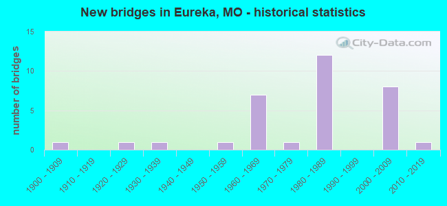
- New bridges - historical statistics
- 11900-1909
- 11920-1929
- 11930-1939
- 11950-1959
- 71960-1969
- 11970-1979
- 121980-1989
- 82000-2009
- 12010-2019
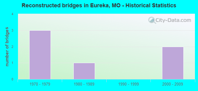
- Reconstructed bridges - Historical Statistics
- 31970-1979
- 11980-1989
- 01990-1999
- 22000-2009
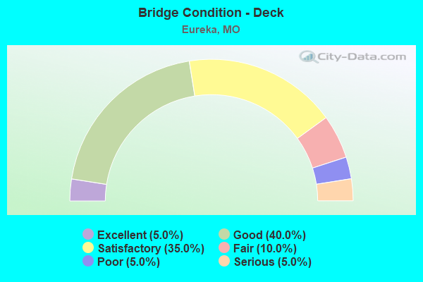
- Bridge Condition - Deck
- 5.0%Excellent
- 40.0%Good
- 35.0%Satisfactory
- 10.0%Fair
- 5.0%Poor
- 5.0%Serious
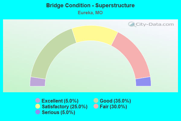
- Bridge Condition - Superstructure
- 5.0%Excellent
- 35.0%Good
- 25.0%Satisfactory
- 30.0%Fair
- 5.0%Serious
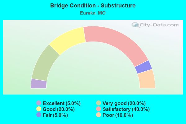
- Bridge Condition - Substructure
- 5.0%Excellent
- 20.0%Very good
- 20.0%Good
- 40.0%Satisfactory
- 5.0%Fair
- 10.0%Poor
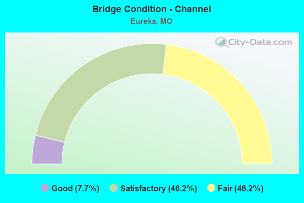
- Bridge Condition - Channel
- 7.7%Good
- 46.2%Satisfactory
- 46.2%Fair
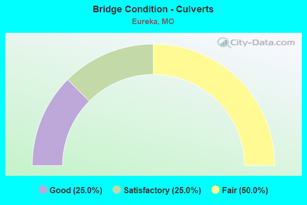
- Bridge Condition - Culverts
- 25.0%Good
- 25.0%Satisfactory
- 50.0%Fair
Find on map >> Show street view
Structure Number: 12521, Location: S 18 T 43 N R 4 E (Lat: 38.468086, Lng: -90.623889), Route carried "on" structure: County highway 130, Year Built: 1908, Year Reconstructed: 1983, Status: Posted for load, Structure Length: 8.99m (29.49ft), Average Daily Traffic: 1,500 (year 2021), Truck Traffic: 2%, Average Future Daily Traffic: 3,000 (year 2041), Design Load: H 15, Features Intersected: BIG RVR, Facility Carried by Structure: TWIN RIVERS RD
Minimum Vertical Clearance: 30+ m (98+ ft), Kilometerpoint: 0.080, Lanes on structure: 2, Owner: County Highway Agency, Approaching Roadway Width: 5.5m (18.0ft), Material/Design: Steel continuous, Design/Construction: Stringer/Multi-beam, Number Of Spans In Main Unit: 2, Number Of Approach Spans: 1, Length of Maximum Span: 38.1m (125.0ft), Curb-To-Curb Width: 8.4m (27.6ft), Out-to-Out Width: 8.4m (27.6ft)
Condition: Deck: Satisfactory, Superstructure: Fair, Substructure: Satisfactory, Channel: Good, Operating Rating: 38.7 metric tons, Method Used To Determine Operating Rating: Allowable Stress (AS), Inventory Rating: 22.5 metric tons, Method Used To Determine Inventory Rating: Allowable Stress (AS), Structural Evaluation: Somewhat better than minimum adequacy, Deck Geometry: Meets minimum limits, Waterway Adequacy: Somewhat better than minimum adequacy, Approach Roadway Alignment: Equal to present desirable criteria, Designated Inspection Frequency: Every 24 months, Inspection Date: Febuary 2021, Deck Structure Type: Concrete Cast-file-Place, Wearing Surface/Protective System: Wearing Surface: Bituminous
Find on map >> Show street view
Structure Number: 1489, Location: S 2071 T 44 N R 4 E (Lat: 38.505725, Lng: -90.616989), Route carried "on" structure: ServiceState highway 44, Year Built: 1968, Status: Posted for load, Structure Length: 3.44m (11.29ft), Average Daily Traffic: 96 (year 2021), Truck Traffic: 6%, Average Future Daily Traffic: 144 (year 2041), Design Load: H 15, Features Intersected: UP RR
Minimum Vertical Clearance: 30+ m (98+ ft), Kilometerpoint: 7.459, Lanes on structure: 2, Owner: State Highway Agency, Approaching Roadway Width: 6.7m (22.0ft), Skew: 1 degrees, Material/Design: Steel continuous, Design/Construction: Stringer/Multi-beam, Number Of Spans In Main Unit: 3, Length of Maximum Span: 15.2m (49.9ft), Curb-To-Curb Width: 8.5m (27.9ft), Out-to-Out Width: 9.4m (30.8ft)
Condition: Deck: Fair, Superstructure: Fair, Substructure: Good, Operating Rating: 30.6 metric tons, Method Used To Determine Operating Rating: Load Factor (LF), Inventory Rating: 18.0 metric tons, Method Used To Determine Inventory Rating: Load Factor (LF), Structural Evaluation: Somewhat better than minimum adequacy, Deck Geometry: Better than present minimum criteria, Underclear: Somewhat better than minimum adequacy, Approach Roadway Alignment: Equal to present desirable criteria, Designated Inspection Frequency: Every 24 months, Inspection Date: July 2020, Deck Structure Type: Concrete Cast-file-Place, Wearing Surface/Protective System: Wearing Surface: Other
Find on map >> Show street view
Structure Number: 149, Location: S 30 T 29 N R 23 W (Lat: 37.185817, Lng: -93.493511), Route carried "on" structure: Interstate 44, Year Built: 1960, Year Reconstructed: 1992, Status: Open, Structure Length: 5.43m (17.81ft), Average Daily Traffic: 17,150 (year 2021), Truck Traffic: 26%, Average Future Daily Traffic: 26,583 (year 2041), Design Load: HS 20, Features Intersected: POND CR
Minimum Vertical Clearance: 30+ m (98+ ft), Kilometerpoint: 365.311, Lanes on structure: 2, Base Highway Network: Yes, Owner: State Highway Agency, Approaching Roadway Width: 11.0m (36.1ft), Skew: 1 degrees, Material/Design: Prestressed concrete, Design/Construction: Stringer/Multi-beam, Number Of Spans In Main Unit: 3, Length of Maximum Span: 19.1m (62.7ft), Curb or Sidewalk Widths: Left: 0.2m (0.7ft), Right: 0.2m (0.7ft), Curb-To-Curb Width: 11.3m (37.1ft), Out-to-Out Width: 12.2m (40.0ft)
Condition: Deck: Good, Superstructure: Satisfactory, Substructure: Good, Channel: Satisfactory, Operating Rating: 59.4 metric tons, Method Used To Determine Operating Rating: Load Factor (LF), Inventory Rating: 32.4 metric tons, Method Used To Determine Inventory Rating: Load Factor (LF), Structural Evaluation: Equal to present minimum criteria, Deck Geometry: Somewhat better than minimum adequacy, Waterway Adequacy: Equal to present desirable criteria, Approach Roadway Alignment: Equal to present desirable criteria, Designated Inspection Frequency: Every 24 months, Inspection Date: August 2020, Deck Structure Type: Concrete Cast-file-Place, Wearing Surface/Protective System: Wearing Surface: Monolithic Concrete, Deck Protection: Epoxy Coated Reinforcing
Find on map >> Show street view
Structure Number: 149, Location: S 32 T 44 N R 4 E (Lat: 38.504244, Lng: -90.592033), Route carried "on" structure: Interstate 44, Year Built: 1968, Year Reconstructed: 1983, Status: Open, Structure Length: 39.87m (130.81ft), Average Daily Traffic: 34,903 (year 2021), Truck Traffic: 12%, Average Future Daily Traffic: 43,629 (year 2041), Design Load: HS 20+Mod, Features Intersected: MERAMEC RVR, SOUTH OUTER
Minimum Vertical Clearance: 30+ m (98+ ft), Kilometerpoint: 43.095, Lanes on structure: 3, Lanes under structure: 3, Base Highway Network: Yes, Owner: State Highway Agency, Approaching Roadway Width: 16.1m (52.8ft), Skew: 30 degrees, Material/Design: Steel continuous, Design/Construction: Stringer/Multi-beam, Number Of Spans In Main Unit: 15, Length of Maximum Span: 45.7m (149.9ft), Curb-To-Curb Width: 12.0m (39.4ft), Out-to-Out Width: 12.4m (40.7ft)
Condition: Deck: Poor, Superstructure: Fair, Substructure: Satisfactory, Channel: Satisfactory, Operating Rating: 51.3 metric tons, Method Used To Determine Operating Rating: Load Factor (LF), Inventory Rating: 30.6 metric tons, Method Used To Determine Inventory Rating: Load Factor (LF), Structural Evaluation: Somewhat better than minimum adequacy, Deck Geometry: High priority of corrective action, Underclear: Better than present minimum criteria, Waterway Adequacy: Equal to present desirable criteria, Approach Roadway Alignment: Better than present minimum criteria, Length Of Structure Improvement: 3.99m (13.09ft), Designated Inspection Frequency: Every 24 months, Underwater Inspection Frequency: Every 60 months, Inspection Date: September 2021, Underwater Inspection Date: June 2020, Bridge Improvement Cost: $5,390,000, Roadway Improvement Cost: $539,000, Total Project Cost: $8,086,000 ( Estimate for 2022), Deck Structure Type: Concrete Cast-file-Place, Wearing Surface/Protective System: Wearing Surface: Other
Find on map >> Show street view
Structure Number: 1491, Location: S 33 T 44 N R 4 E (Lat: 38.505183, Lng: -90.585719), Route carried "on" structure: County highway , Year Built: 1968, Year Reconstructed: 2009, Status: Open, Structure Length: 7.25m (23.79ft), Average Daily Traffic: 3,373 (year 2021), Truck Traffic: 4%, Average Future Daily Traffic: 5,060 (year 2041), Design Load: H 20, Features Intersected: IS 44, Facility Carried by Structure: LEWIS RD S
Minimum Vertical Clearance: 30+ m (98+ ft), Kilometerpoint: 4.554, Lanes on structure: 2, Lanes under structure: 6, Owner: State Highway Agency, Approaching Roadway Width: 12.2m (40.0ft), Skew: 3 degrees, Material/Design: Steel continuous, Design/Construction: Stringer/Multi-beam, Number Of Spans In Main Unit: 4, Length of Maximum Span: 21.0m (68.9ft), Curb-To-Curb Width: 12.2m (40.0ft), Out-to-Out Width: 13.0m (42.7ft)
Condition: Deck: Good, Superstructure: Good, Substructure: Satisfactory, Operating Rating: 58.5 metric tons, Method Used To Determine Operating Rating: Load Factor (LF), Inventory Rating: 35.1 metric tons, Method Used To Determine Inventory Rating: Load Factor (LF), Structural Evaluation: Equal to present minimum criteria, Deck Geometry: Equal to present minimum criteria, Underclear: Somewhat better than minimum adequacy, Approach Roadway Alignment: Somewhat better than minimum adequacy, Designated Inspection Frequency: Every 24 months, Inspection Date: July 2020, Deck Structure Type: Concrete Cast-file-Place, Wearing Surface/Protective System: Wearing Surface: Monolithic Concrete, Deck Protection: Epoxy Coated Reinforcing
Find on map >> Show street view
Structure Number: 15607, Location: S 30 T 44 N R 4 E (Lat: 38.523606, Lng: -90.611869), Route carried "on" structure: County highway , Year Built: 1930, Status: Posted for load, Structure Length: 3.57m (11.71ft), Average Daily Traffic: 369 (year 2020), Truck Traffic: 6%, Average Future Daily Traffic: 498 (year 2040), Design Load: H 20, Features Intersected: UP RR, Facility Carried by Structure: ALLEN RD
Minimum Vertical Clearance: 30+ m (98+ ft), Kilometerpoint: 4.667, Lanes on structure: 2, Owner: Railroad, Maintenance Responsibility: County Highway Agency, Approaching Roadway Width: 6.1m (20.0ft), Material/Design: Concrete, Design/Construction: Tee Beam, Number Of Spans In Main Unit: 3, Length of Maximum Span: 11.9m (39.0ft), Curb-To-Curb Width: 6.2m (20.3ft), Out-to-Out Width: 6.9m (22.6ft)
Condition: Deck: Fair, Superstructure: Fair, Substructure: Poor, Operating Rating: 27.0 metric tons, Method Used To Determine Operating Rating: Load Factor (LF), Inventory Rating: 3.6 metric tons, Method Used To Determine Inventory Rating: Load Factor (LF), Structural Evaluation: High priority of replacement, Deck Geometry: Meets minimum limits, Underclear: Meets minimum limits, Approach Roadway Alignment: Meets minimum limits, Bridge Posting: Required (Relationship of Operating Rating to Maximum Legal Load: 30.0 - 39.9% below), Length Of Structure Improvement: 0.45m (1.48ft), Designated Inspection Frequency: Every 24 months, Inspection Date: Febuary 2021, Bridge Improvement Cost: $408,000, Roadway Improvement Cost: $41,000, Total Project Cost: $613,000 ( Estimate for 2022), Deck Structure Type: Concrete Cast-file-Place, Wearing Surface/Protective System: Wearing Surface: Bituminous
Find on map >> Show street view
Structure Number: 1689, Location: S 16 T 31 N R 20 W (Lat: 37.415758, Lng: -93.145236), Route carried "on" structure: US 65, Year Built: 1967, Year Reconstructed: 2012, Status: Open, Structure Length: 12.10m (39.70ft), Average Daily Traffic: 5,593 (year 2021), Truck Traffic: 10%, Average Future Daily Traffic: 8,669 (year 2041), Design Load: H 20, Features Intersected: POMME DE TERRE RVR
Minimum Vertical Clearance: 30+ m (98+ ft), Kilometerpoint: 107.968, Lanes on structure: 2, Base Highway Network: Yes, Owner: State Highway Agency, Approaching Roadway Width: 11.6m (38.1ft), Skew: 1 degrees, Material/Design: Steel continuous, Design/Construction: Stringer/Multi-beam, Number Of Spans In Main Unit: 4, Length of Maximum Span: 34.1m (111.9ft), Curb-To-Curb Width: 9.8m (32.2ft), Out-to-Out Width: 10.6m (34.8ft)
Condition: Deck: Good, Superstructure: Satisfactory, Substructure: Good, Channel: Fair, Operating Rating: 42.3 metric tons, Method Used To Determine Operating Rating: Load Factor (LF), Inventory Rating: 25.2 metric tons, Method Used To Determine Inventory Rating: Load Factor (LF), Structural Evaluation: Equal to present minimum criteria, Deck Geometry: Meets minimum limits, Waterway Adequacy: Equal to present desirable criteria, Approach Roadway Alignment: Equal to present desirable criteria, Designated Inspection Frequency: Every 24 months, Inspection Date: July 2020, Deck Structure Type: Concrete Cast-file-Place, Wearing Surface/Protective System: Wearing Surface: Monolithic Concrete, Deck Protection: Epoxy Coated Reinforcing
Find on map >> Show street view
Structure Number: 1689, Location: S 36 T 44 N R 3 E (Lat: 38.516278, Lng: -90.641722), Route carried "on" structure: City street , Year Built: 1978, Status: Posted for load, Structure Length: 1.22m (4.00ft), Average Daily Traffic: 800 (year 2020), Truck Traffic: 1%, Average Future Daily Traffic: 1,080 (year 2040), Features Intersected: CLIFTY CR, Facility Carried by Structure: MERAMEC BLVD
Minimum Vertical Clearance: 30+ m (98+ ft), Kilometerpoint: 0.483, Lanes on structure: 2, Owner: City or Municipal Highway Agency, Approaching Roadway Width: 11.0m (36.1ft), Material/Design: Concrete continuous, Design/Construction: Slab, Number Of Spans In Main Unit: 3, Length of Maximum Span: 4.0m (13.1ft), Curb-To-Curb Width: 12.3m (40.4ft), Out-to-Out Width: 14.3m (46.9ft)
Condition: Deck: Satisfactory, Superstructure: Satisfactory, Substructure: Satisfactory, Channel: Satisfactory, Operating Rating: 24.3 metric tons, Method Used To Determine Operating Rating: Allowable Stress (AS), Inventory Rating: 12.6 metric tons, Method Used To Determine Inventory Rating: Allowable Stress (AS), Structural Evaluation: Meets minimum limits, Deck Geometry: Superior to present desirable criteria, Waterway Adequacy: Equal to present desirable criteria, Approach Roadway Alignment: Equal to present desirable criteria, Bridge Posting: Required (Relationship of Operating Rating to Maximum Legal Load: 0.1 - 9.9% below), Designated Inspection Frequency: Every 24 months, Inspection Date: November 2021, Deck Structure Type: Concrete Cast-file-Place, Wearing Surface/Protective System: Wearing Surface: Bituminous, Membrane: Epoxy
Find on map >> Show street view
Structure Number: 16891, Location: S 34 T 44 N R 3 E (Lat: 38.504056, Lng: -90.676361), Route carried "on" structure: City street , Year Built: 1928, Status: Posted for load, Structure Length: 3.32m (10.89ft), Average Daily Traffic: 1,000 (year 2020), Truck Traffic: 10%, Average Future Daily Traffic: 1,350 (year 2040), Features Intersected: UP RR, Facility Carried by Structure: ALLENTON RD
Minimum Vertical Clearance: 30+ m (98+ ft), Kilometerpoint: 0.805, Lanes on structure: 1, Owner: City or Municipal Highway Agency, Approaching Roadway Width: 6.1m (20.0ft), Material/Design: Concrete, Design/Construction: Tee Beam, Number Of Spans In Main Unit: 4, Length of Maximum Span: 9.8m (32.2ft), Curb-To-Curb Width: 6.1m (20.0ft), Out-to-Out Width: 7.4m (24.3ft)
Condition: Deck: Serious, Superstructure: Serious, Substructure: Poor, Operating Rating: 10.8 metric tons, Method Used To Determine Operating Rating: Field evaluation and documented engineering judgment, Inventory Rating: 6.3 metric tons, Method Used To Determine Inventory Rating: Field evaluation and documented engineering judgment, Structural Evaluation: High priority of replacement, Deck Geometry: High priority of corrective action, Approach Roadway Alignment: High priority of corrective action, Bridge Posting: Required (Relationship of Operating Rating to Maximum Legal Load: > 39.9% below), Length Of Structure Improvement: 0.42m (1.38ft), Designated Inspection Frequency: Every 12 months, Inspection Date: November 2021, Bridge Improvement Cost: $455,000, Roadway Improvement Cost: $46,000, Total Project Cost: $683,000 ( Estimate for 2022), Deck Structure Type: Concrete Cast-file-Place
Find on map >> Show street view
Structure Number: 29015, Location: S 4 T 43 N R 3 E (Lat: 38.499675, Lng: -90.688753), Route carried "on" structure: Business State highway 44, Year Built: 2004, Status: Open, Structure Length: 6.43m (21.10ft), Average Daily Traffic: 7,949 (year 2021), Truck Traffic: 8%, Average Future Daily Traffic: 11,129 (year 2041), Design Load: HS 20, Features Intersected: FOX CR
Minimum Vertical Clearance: 30+ m (98+ ft), Kilometerpoint: 12.942, Lanes on structure: 2, Owner: State Highway Agency, Approaching Roadway Width: 11.0m (36.1ft), Skew: 2 degrees, Material/Design: Prestressed concrete continuous, Design/Construction: Stringer/Multi-beam, Number Of Spans In Main Unit: 3, Length of Maximum Span: 25.0m (82.0ft), Curb-To-Curb Width: 12.0m (39.4ft), Out-to-Out Width: 12.8m (42.0ft)
Condition: Deck: Good, Superstructure: Good, Substructure: Very good, Channel: Fair, Operating Rating: 67.5 metric tons, Method Used To Determine Operating Rating: Load Factor (LF), Inventory Rating: 36.9 metric tons, Method Used To Determine Inventory Rating: Load Factor (LF), Structural Evaluation: Better than present minimum criteria, Deck Geometry: Somewhat better than minimum adequacy, Waterway Adequacy: Superior to present desirable criteria, Approach Roadway Alignment: Better than present minimum criteria, Designated Inspection Frequency: Every 24 months, Inspection Date: July 2020, Deck Structure Type: Concrete Cast-file-Place, Wearing Surface/Protective System: Wearing Surface: Epoxy Overlay, Deck Protection: Epoxy Coated Reinforcing
Find on map >> Show street view
Structure Number: 29076, Location: S 34 T 44 N R 3 E (Lat: 38.505614, Lng: -90.677175), Route carried "on" structure: Interstate 44, Year Built: 2002, Status: Open, Structure Length: 8.26m (27.10ft), Average Daily Traffic: 26,286 (year 2021), Truck Traffic: 22%, Average Future Daily Traffic: 32,858 (year 2041), Design Load: HS 25 or greater, Features Intersected: LP 44
Minimum Vertical Clearance: 30+ m (98+ ft), Kilometerpoint: 420.802, Lanes on structure: 3, Lanes under structure: 10, Base Highway Network: Yes, Owner: State Highway Agency, Approaching Roadway Width: 16.5m (54.1ft), Skew: 12 degrees, Material/Design: Steel continuous, Design/Construction: Stringer/Multi-beam, Number Of Spans In Main Unit: 4, Length of Maximum Span: 27.1m (88.9ft), Curb-To-Curb Width: 16.6m (54.5ft), Out-to-Out Width: 17.4m (57.1ft)
Condition: Deck: Satisfactory, Superstructure: Good, Substructure: Very good, Operating Rating: 90.0 metric tons, Method Used To Determine Operating Rating: Load Factor (LF), Inventory Rating: 54.0 metric tons, Method Used To Determine Inventory Rating: Load Factor (LF), Structural Evaluation: Better than present minimum criteria, Deck Geometry: Equal to present minimum criteria, Underclear: Somewhat better than minimum adequacy, Approach Roadway Alignment: Equal to present desirable criteria, Designated Inspection Frequency: Every 24 months, Inspection Date: July 2020, Deck Structure Type: Concrete Cast-file-Place, Wearing Surface/Protective System: Wearing Surface: Epoxy Overlay, Deck Protection: Epoxy Coated Reinforcing
Find on map >> Show street view
Structure Number: 29077, Location: S 34 T 44 N R 3 E (Lat: 38.505781, Lng: -90.677272), Route carried "on" structure: Interstate 44, Year Built: 2002, Status: Open, Structure Length: 8.26m (27.10ft), Average Daily Traffic: 29,112 (year 2021), Truck Traffic: 27%, Average Future Daily Traffic: 36,390 (year 2041), Design Load: HS 20+Mod, Features Intersected: LP 44
Minimum Vertical Clearance: 30+ m (98+ ft), Kilometerpoint: 50.826, Lanes on structure: 3, Lanes under structure: 10, Base Highway Network: Yes, Owner: State Highway Agency, Approaching Roadway Width: 17.4m (57.1ft), Skew: 12 degrees, Material/Design: Steel continuous, Design/Construction: Stringer/Multi-beam, Number Of Spans In Main Unit: 4, Length of Maximum Span: 27.1m (88.9ft), Curb-To-Curb Width: 16.6m (54.5ft), Out-to-Out Width: 17.4m (57.1ft)
Condition: Deck: Good, Superstructure: Good, Substructure: Very good, Operating Rating: 92.7 metric tons, Method Used To Determine Operating Rating: Load Factor (LF), Inventory Rating: 55.8 metric tons, Method Used To Determine Inventory Rating: Load Factor (LF), Structural Evaluation: Better than present minimum criteria, Deck Geometry: Equal to present minimum criteria, Underclear: Somewhat better than minimum adequacy, Approach Roadway Alignment: Equal to present desirable criteria, Designated Inspection Frequency: Every 24 months, Inspection Date: July 2020, Deck Structure Type: Concrete Cast-file-Place, Wearing Surface/Protective System: Wearing Surface: Epoxy Overlay, Deck Protection: Epoxy Coated Reinforcing
Find on map >> Show street view
Structure Number: 31123, Location: S 2071 T 43 N R 3 E (Lat: 38.500125, Lng: -90.630861), Route carried "on" structure: City street , Year Built: 2007, Status: Open, Structure Length: 1.06m (3.48ft), Average Daily Traffic: 1,000 (year 2020), Truck Traffic: 1%, Average Future Daily Traffic: 1,350 (year 2040), Design Load: HS 20, Features Intersected: FLAT CR, Facility Carried by Structure: BALD HILL RD
Minimum Vertical Clearance: 30+ m (98+ ft), Kilometerpoint: 4.828, Lanes on structure: 2, Owner: City or Municipal Highway Agency, Approaching Roadway Width: 12.2m (40.0ft), Material/Design: Concrete continuous, Design/Construction: Culvert, Number Of Spans In Main Unit: 3, Length of Maximum Span: 3.5m (11.5ft), Curb or Sidewalk Widths: Left: 1.7m (5.6ft), Right: 1.7m (5.6ft), Curb-To-Curb Width: 7.6m (24.9ft), Out-to-Out Width: 12.2m (40.0ft)
Condition: Channel: Fair, Culverts: Good, Operating Rating: 54.0 metric tons, Method Used To Determine Operating Rating: Field evaluation and documented engineering judgment, Inventory Rating: 32.4 metric tons, Method Used To Determine Inventory Rating: Field evaluation and documented engineering judgment, Structural Evaluation: Better than present minimum criteria, Deck Geometry: Meets minimum limits, Waterway Adequacy: Equal to present minimum criteria, Approach Roadway Alignment: Equal to present desirable criteria, Designated Inspection Frequency: Every 24 months, Inspection Date: November 2021
Find on map >> Show street view
Structure Number: 31357, Location: S 36 T 44 N R 3 E (Lat: 38.516417, Lng: -90.637806), Route carried "on" structure: City street 135, Year Built: 2006, Status: Open, Structure Length: 1.72m (5.64ft), Average Daily Traffic: 1,192 (year 2020), Truck Traffic: 2%, Average Future Daily Traffic: 1,609 (year 2040), Design Load: HS 20, Features Intersected: FLAT CR, Facility Carried by Structure: FORBY RD
Minimum Vertical Clearance: 30+ m (98+ ft), Kilometerpoint: 0.322, Lanes on structure: 2, Owner: City or Municipal Highway Agency, Approaching Roadway Width: 14.0m (45.9ft), Skew: 2 degrees, Material/Design: Concrete, Design/Construction: Culvert, Number Of Spans In Main Unit: 3, Length of Maximum Span: 5.5m (18.0ft)
Condition: Channel: Satisfactory, Culverts: Satisfactory, Operating Rating: 56.7 metric tons, Method Used To Determine Operating Rating: Load Factor (LF), Inventory Rating: 37.8 metric tons, Method Used To Determine Inventory Rating: Load Factor (LF), Structural Evaluation: Equal to present minimum criteria, Waterway Adequacy: Superior to present desirable criteria, Approach Roadway Alignment: Equal to present desirable criteria, Designated Inspection Frequency: Every 24 months, Inspection Date: November 2021
Find on map >> Show street view
Structure Number: 3298, Location: S 2071 T 44 N R 4 E (Lat: 38.505433, Lng: -90.617197), Route carried "on" structure: Interstate 44, Year Built: 1983, Status: Open, Structure Length: 5.03m (16.50ft), Average Daily Traffic: 70,568 (year 2021), Truck Traffic: 12%, Average Future Daily Traffic: 88,210 (year 2041), Design Load: HS 20+Mod, Features Intersected: UP RR
Minimum Vertical Clearance: 30+ m (98+ ft), Kilometerpoint: 426.126, Lanes on structure: 6, Base Highway Network: Yes, Owner: State Highway Agency, Approaching Roadway Width: 34.7m (113.8ft), Skew: 22 degrees, Material/Design: Prestressed concrete continuous, Design/Construction: Stringer/Multi-beam, Number Of Spans In Main Unit: 3, Length of Maximum Span: 18.6m (61.0ft), Curb or Sidewalk Widths: Left: 0.2m (0.7ft), Right: 0.2m (0.7ft), Curb-To-Curb Width: 34.7m (113.8ft), Out-to-Out Width: 35.6m (116.8ft)
Condition: Deck: Satisfactory, Superstructure: Good, Substructure: Satisfactory, Operating Rating: 69.3 metric tons, Method Used To Determine Operating Rating: Load Factor (LF), Inventory Rating: 37.8 metric tons, Method Used To Determine Inventory Rating: Load Factor (LF), Structural Evaluation: Equal to present minimum criteria, Deck Geometry: Superior to present desirable criteria, Underclear: Equal to present minimum criteria, Approach Roadway Alignment: Equal to present desirable criteria, Designated Inspection Frequency: Every 24 months, Inspection Date: July 2020, Deck Structure Type: Concrete Cast-file-Place, Wearing Surface/Protective System: Wearing Surface: Epoxy Overlay, Deck Protection: Epoxy Coated Reinforcing
Find on map >> Show street view
Structure Number: 3299, Location: S 2071 T 44 N R 4 E (Lat: 38.504728, Lng: -90.612925), Route carried "on" structure: Interstate 44, Year Built: 1983, Status: Open, Structure Length: 10.39m (34.09ft), Average Daily Traffic: 70,568 (year 2021), Truck Traffic: 12%, Average Future Daily Traffic: 88,210 (year 2041), Design Load: HS 20+Mod, Features Intersected: BNSF RR, CR
Minimum Vertical Clearance: 30+ m (98+ ft), Kilometerpoint: 426.493, Lanes on structure: 6, Base Highway Network: Yes, Owner: State Highway Agency, Approaching Roadway Width: 34.7m (113.8ft), Skew: 23 degrees, Material/Design: Prestressed concrete continuous, Design/Construction: Stringer/Multi-beam, Number Of Spans In Main Unit: 4, Length of Maximum Span: 28.7m (94.2ft), Curb or Sidewalk Widths: Left: 0.2m (0.7ft), Right: 0.2m (0.7ft), Curb-To-Curb Width: 34.7m (113.8ft), Out-to-Out Width: 35.6m (116.8ft)
Condition: Deck: Satisfactory, Superstructure: Fair, Substructure: Satisfactory, Channel: Satisfactory, Operating Rating: 83.7 metric tons, Method Used To Determine Operating Rating: Load Factor (LF), Inventory Rating: 24.3 metric tons, Method Used To Determine Inventory Rating: Load Factor (LF), Structural Evaluation: Somewhat better than minimum adequacy, Deck Geometry: Superior to present desirable criteria, Underclear: Superior to present desirable criteria, Waterway Adequacy: Equal to present desirable criteria, Approach Roadway Alignment: Equal to present desirable criteria, Designated Inspection Frequency: Every 24 months, Inspection Date: July 2020, Deck Structure Type: Concrete Cast-file-Place, Wearing Surface/Protective System: Wearing Surface: Epoxy Overlay, Deck Protection: Epoxy Coated Reinforcing
Find on map >> Show street view
Structure Number: 34644, Location: S 2010 T 44 N R 3 E (Lat: 38.502917, Lng: -90.655750), Route carried "on" structure: City street , Year Built: 2006, Status: Open, Structure Length: 0.94m (3.08ft), Average Daily Traffic: 5,000 (year 2020), Truck Traffic: 10%, Average Future Daily Traffic: 6,750 (year 2040), Design Load: HS 20, Features Intersected: FLAT CR, Facility Carried by Structure: W MAIN ST
Minimum Vertical Clearance: 30+ m (98+ ft), Kilometerpoint: 2.575, Lanes on structure: 2, Owner: City or Municipal Highway Agency, Approaching Roadway Width: 9.8m (32.2ft), Skew: 2 degrees, Material/Design: Concrete continuous, Design/Construction: Culvert, Number Of Spans In Main Unit: 2, Length of Maximum Span: 3.7m (12.1ft)
Condition: Channel: Fair, Culverts: Fair, Operating Rating: 54.0 metric tons, Method Used To Determine Operating Rating: Field evaluation and documented engineering judgment, Inventory Rating: 32.4 metric tons, Method Used To Determine Inventory Rating: Field evaluation and documented engineering judgment, Structural Evaluation: Somewhat better than minimum adequacy, Waterway Adequacy: Superior to present desirable criteria, Approach Roadway Alignment: High priority of corrective action, Designated Inspection Frequency: Every 24 months, Inspection Date: November 2021
Find on map >> Show street view
Structure Number: 3502, Location: S 31 T 44 N R 4 E (Lat: 38.512619, Lng: -90.623836), Route carried "on" structure: State highway 109, Year Built: 1988, Status: Open, Structure Length: 1.21m (3.97ft), Average Daily Traffic: 19,164 (year 2021), Truck Traffic: 3%, Average Future Daily Traffic: 26,830 (year 2041), Design Load: HS 20, Features Intersected: CLIFTY CR
Minimum Vertical Clearance: 30+ m (98+ ft), Kilometerpoint: 16.853, Lanes on structure: 4, Base Highway Network: Yes, Owner: State Highway Agency, Approaching Roadway Width: 25.6m (84.0ft), Skew: 2 degrees, Material/Design: Concrete continuous, Design/Construction: Culvert, Number Of Spans In Main Unit: 3, Length of Maximum Span: 3.7m (12.1ft)
Condition: Channel: Fair, Culverts: Fair, Operating Rating: 87.3 metric tons, Method Used To Determine Operating Rating: Field evaluation and documented engineering judgment, Inventory Rating: 52.2 metric tons, Method Used To Determine Inventory Rating: Field evaluation and documented engineering judgment, Structural Evaluation: Somewhat better than minimum adequacy, Waterway Adequacy: Equal to present desirable criteria, Approach Roadway Alignment: Equal to present desirable criteria, Designated Inspection Frequency: Every 24 months, Inspection Date: November 2021
Find on map >> Show street view
Structure Number: 3503, Location: S 2071 T 44 N R 4 E (Lat: 38.506356, Lng: -90.623325), Route carried "on" structure: Interstate 44, Year Built: 1986, Status: Open, Structure Length: 5.15m (16.90ft), Average Daily Traffic: 65,459 (year 2021), Truck Traffic: 12%, Average Future Daily Traffic: 81,824 (year 2041), Design Load: HS 20+Mod, Features Intersected: MO 109
Minimum Vertical Clearance: 30+ m (98+ ft), Kilometerpoint: 425.589, Lanes on structure: 6, Lanes under structure: 6, Base Highway Network: Yes, Owner: State Highway Agency, Approaching Roadway Width: 34.7m (113.8ft), Skew: 20 degrees, Material/Design: Prestressed concrete continuous, Design/Construction: Stringer/Multi-beam, Number Of Spans In Main Unit: 2, Length of Maximum Span: 25.8m (84.6ft), Curb or Sidewalk Widths: Left: 0.2m (0.7ft), Right: 0.2m (0.7ft), Curb-To-Curb Width: 34.4m (112.9ft), Out-to-Out Width: 35.2m (115.5ft)
Condition: Deck: Satisfactory, Superstructure: Good, Substructure: Good, Operating Rating: 62.1 metric tons, Method Used To Determine Operating Rating: Load Factor (LF), Inventory Rating: 36.0 metric tons, Method Used To Determine Inventory Rating: Load Factor (LF), Structural Evaluation: Better than present minimum criteria, Deck Geometry: Superior to present desirable criteria, Underclear: Equal to present minimum criteria, Approach Roadway Alignment: Equal to present desirable criteria, Designated Inspection Frequency: Every 24 months, Inspection Date: July 2020, Deck Structure Type: Concrete Cast-file-Place, Wearing Surface/Protective System: Wearing Surface: Monolithic Concrete, Deck Protection: Epoxy Coated Reinforcing
Find on map >> Show street view
Structure Number: 3504, Location: S 2071 T 44 N R 4 E (Lat: 38.502797, Lng: -90.624400), Route carried "on" structure: State highway 109, Year Built: 1987, Status: Open, Structure Length: 12.10m (39.70ft), Average Daily Traffic: 20,748 (year 2021), Truck Traffic: 5%, Average Future Daily Traffic: 29,047 (year 2041), Design Load: HS 20, Features Intersected: CST E FIRST ST, BNSF RR,
Minimum Vertical Clearance: 30+ m (98+ ft), Kilometerpoint: 17.999, Lanes on structure: 4, Lanes under structure: 2, Base Highway Network: Yes, Owner: State Highway Agency, Approaching Roadway Width: 25.6m (84.0ft), Skew: 21 degrees, Material/Design: Prestressed concrete continuous, Design/Construction: Stringer/Multi-beam, Number Of Spans In Main Unit: 7, Length of Maximum Span: 17.9m (58.7ft), Curb or Sidewalk Widths: Left: 0.2m (0.7ft), Right: 0.2m (0.7ft), Curb-To-Curb Width: 25.2m (82.7ft), Out-to-Out Width: 26.1m (85.6ft)
Condition: Deck: Good, Superstructure: Good, Substructure: Very good, Operating Rating: 66.6 metric tons, Method Used To Determine Operating Rating: Load Factor (LF), Inventory Rating: 36.9 metric tons, Method Used To Determine Inventory Rating: Load Factor (LF), Structural Evaluation: Better than present minimum criteria, Deck Geometry: Superior to present desirable criteria, Underclear: Equal to present minimum criteria, Approach Roadway Alignment: Equal to present desirable criteria, Designated Inspection Frequency: Every 24 months, Inspection Date: July 2020, Deck Structure Type: Concrete Cast-file-Place, Wearing Surface/Protective System: Wearing Surface: Epoxy Overlay, Deck Protection: Epoxy Coated Reinforcing
Find on map >> Show street view
Structure Number: 3505, Location: S 2071 T 43 N R 3 E (Lat: 38.498922, Lng: -90.626786), Route carried "on" structure: State highway 109, Year Built: 1987, Status: Posted for load, Structure Length: 3.60m (11.81ft), Average Daily Traffic: 20,748 (year 2021), Truck Traffic: 5%, Average Future Daily Traffic: 29,047 (year 2041), Design Load: HS 20+Mod, Features Intersected: FLAT CR, BIKE PATH
Minimum Vertical Clearance: 30+ m (98+ ft), Kilometerpoint: 18.517, Lanes on structure: 4, Base Highway Network: Yes, Owner: State Highway Agency, Approaching Roadway Width: 25.6m (84.0ft), Skew: 23 degrees, Material/Design: Prestressed concrete continuous, Design/Construction: Tee Beam, Number Of Spans In Main Unit: 3, Length of Maximum Span: 12.1m (39.7ft), Curb or Sidewalk Widths: Left: 0.2m (0.7ft), Right: 0.2m (0.7ft), Curb-To-Curb Width: 25.2m (82.7ft), Out-to-Out Width: 26.1m (85.6ft)
Condition: Deck: Good, Superstructure: Satisfactory, Substructure: Satisfactory, Channel: Fair, Operating Rating: 37.8 metric tons, Method Used To Determine Operating Rating: Load Factor (LF), Inventory Rating: 34.2 metric tons, Method Used To Determine Inventory Rating: Load Factor (LF), Structural Evaluation: Equal to present minimum criteria, Deck Geometry: Superior to present desirable criteria, Waterway Adequacy: Equal to present desirable criteria, Approach Roadway Alignment: Equal to present desirable criteria, Designated Inspection Frequency: Every 24 months, Inspection Date: July 2020, Deck Structure Type: Concrete Cast-file-Place, Wearing Surface/Protective System: Wearing Surface: Monolithic Concrete, Deck Protection: Epoxy Coated Reinforcing
Find on map >> Show street view
Structure Number: 3506, Location: S 2071 T 44 N R 3 E (Lat: 38.506681, Lng: -90.627858), Route carried "on" structure: City street , Year Built: 1989, Status: Open, Structure Length: 7.32m (24.02ft), Average Daily Traffic: 12,882 (year 2021), Truck Traffic: 5%, Average Future Daily Traffic: 19,323 (year 2041), Design Load: HS 20+Mod, Features Intersected: IS 44, Facility Carried by Structure: CENTRAL AVE S
Minimum Vertical Clearance: 30+ m (98+ ft), Kilometerpoint: 0.375, Lanes on structure: 4, Lanes under structure: 8, Owner: State Highway Agency, Approaching Roadway Width: 16.5m (54.1ft), Skew: 20 degrees, Material/Design: Steel continuous, Design/Construction: Stringer/Multi-beam, Number Of Spans In Main Unit: 4, Length of Maximum Span: 24.1m (79.1ft), Curb or Sidewalk Widths: Left: 1.7m (5.6ft), Right: 1.7m (5.6ft), Curb-To-Curb Width: 16.2m (53.1ft), Out-to-Out Width: 20.0m (65.6ft)
Condition: Deck: Satisfactory, Superstructure: Satisfactory, Substructure: Fair, Operating Rating: 55.8 metric tons, Method Used To Determine Operating Rating: Allowable Stress (AS), Inventory Rating: 36.9 metric tons, Method Used To Determine Inventory Rating: Allowable Stress (AS), Structural Evaluation: Somewhat better than minimum adequacy, Deck Geometry: Meets minimum limits, Underclear: Somewhat better than minimum adequacy, Approach Roadway Alignment: Equal to present desirable criteria, Designated Inspection Frequency: Every 24 months, Inspection Date: July 2020, Deck Structure Type: Concrete Cast-file-Place, Wearing Surface/Protective System: Wearing Surface: Monolithic Concrete, Deck Protection: Epoxy Coated Reinforcing
Find on map >> Show street view
Structure Number: 35884, Location: S 30 T 44 N R 4 E (Lat: 38.523611, Lng: -90.611861), Route carried "on" structure: County highway , Year Built: 2019, Status: Not yet open, Structure Length: 2.78m (9.12ft), Average Daily Traffic: 369 (year 2020), Truck Traffic: 6%, Average Future Daily Traffic: 498 (year 2040), Design Load: HS 20, Features Intersected: UP RR, Facility Carried by Structure: ALLEN RD
Minimum Vertical Clearance: 30+ m (98+ ft), Kilometerpoint: 0.644, Lanes on structure: 2, Owner: County Highway Agency, Approaching Roadway Width: 6.7m (22.0ft), Skew: 2 degrees, Material/Design: Prestressed concrete, Design/Construction: Tee Beam, Number Of Spans In Main Unit: 1, Length of Maximum Span: 26.5m (86.9ft), Curb or Sidewalk Widths: Left: 0.4m (1.3ft), Right: 0.4m (1.3ft), Curb-To-Curb Width: 11.0m (36.1ft), Out-to-Out Width: 11.8m (38.7ft)
Condition: Deck: Excellent, Superstructure: Excellent, Substructure: Excellent, Operating Rating: 63.9 metric tons, Method Used To Determine Operating Rating: Load Factor (LF), Inventory Rating: 49.5 metric tons, Method Used To Determine Inventory Rating: Load Factor (LF), Structural Evaluation: Superior to present desirable criteria, Deck Geometry: Equal to present desirable criteria, Approach Roadway Alignment: Equal to present desirable criteria, Designated Inspection Frequency: Every 24 months, Inspection Date: January 2020, Deck Structure Type: Concrete Precast Panels, Wearing Surface/Protective System: Wearing Surface: Monolithic Concrete, Deck Protection: Epoxy Coated Reinforcing
Find on map >> Show street view
Structure Number: 638, Location: S 32 T 44 N R 4 E (Lat: 38.504078, Lng: -90.591944), Route carried "on" structure: Interstate 44, Year Built: 1954, Year Reconstructed: 1983, Status: Open, Structure Length: 39.84m (130.71ft), Average Daily Traffic: 70,568 (year 2021), Truck Traffic: 12%, Average Future Daily Traffic: 88,210 (year 2041), Design Load: HS 20, Features Intersected: MERAMEC RVR, BACKWOOD DR
Minimum Vertical Clearance: 30+ m (98+ ft), Kilometerpoint: 428.217, Lanes on structure: 4, Lanes under structure: 2, Base Highway Network: Yes, Owner: State Highway Agency, Approaching Roadway Width: 16.1m (52.8ft), Skew: 30 degrees, Material/Design: Prestressed concrete continuous, Design/Construction: Stringer/Multi-beam, Number Of Spans In Main Unit: 17, Length of Maximum Span: 45.7m (149.9ft), Curb-To-Curb Width: 16.1m (52.8ft), Out-to-Out Width: 21.3m (69.9ft)
Condition: Deck: Good, Superstructure: Fair, Substructure: Satisfactory, Channel: Satisfactory, Operating Rating: 67.5 metric tons, Method Used To Determine Operating Rating: Load Factor (LF), Inventory Rating: 32.4 metric tons, Method Used To Determine Inventory Rating: Load Factor (LF), Structural Evaluation: Somewhat better than minimum adequacy, Deck Geometry: Meets minimum limits, Underclear: Better than present minimum criteria, Waterway Adequacy: Equal to present desirable criteria, Approach Roadway Alignment: Equal to present desirable criteria, Designated Inspection Frequency: Every 24 months, Underwater Inspection Frequency: Every 60 months, Inspection Date: September 2021, Underwater Inspection Date: June 2020, Deck Structure Type: Concrete Cast-file-Place, Wearing Surface/Protective System: Wearing Surface: Monolithic Concrete, Deck Protection: Epoxy Coated Reinforcing
Find on map >> Show street view
Structure Number: 1491, Location: S 33 T 44 N R 4 E (Lat: 38.505183, Lng: -90.585719), Route carried "under" structure: Interstate 44, Year Built: 1968, Structure Length: 0. m, Average Daily Traffic: 35,665 (year 2021), Truck Traffic: 12%, Features Intersected: IS 44, Facility Carried by Structure: LEWIS RD S
Minimum Vertical Clearance: 4.80m (15.75ft), Kilometerpoint: 428.988, Lanes on structure: 2, Lanes under structure: 3, Material/Design: Steel continuous, Design/Construction: Stringer/Multi-beam, Length of Maximum Span: 21.0m (68.9ft)
Find on map >> Show street view
Structure Number: 1491, Location: S 33 T 44 N R 4 E (Lat: 38.505183, Lng: -90.585719), Route carried "under" structure: Interstate 44, Year Built: 1968, Structure Length: 0. m, Average Daily Traffic: 36,105 (year 2021), Truck Traffic: 12%, Features Intersected: IS 44, Facility Carried by Structure: LEWIS RD S
Minimum Vertical Clearance: 5.16m (16.93ft), Kilometerpoint: 42.727, Lanes on structure: 2, Lanes under structure: 3, Material/Design: Steel continuous, Design/Construction: Stringer/Multi-beam, Length of Maximum Span: 21.0m (68.9ft)
Find on map >> Show street view
Structure Number: 29076, Location: S 34 T 44 N R 3 E (Lat: 38.505614, Lng: -90.677175), Route carried "under" structure: Business State highway 44, Year Built: 2002, Structure Length: 0. m, Average Daily Traffic: 9,686 (year 2021), Truck Traffic: 21%, Features Intersected: LP 44
Minimum Vertical Clearance: 4.85m (15.91ft), Kilometerpoint: 0.071, Lanes on structure: 3, Lanes under structure: 10, Material/Design: Steel continuous, Design/Construction: Stringer/Multi-beam, Length of Maximum Span: 27.1m (88.9ft)
Find on map >> Show street view
Structure Number: 29077, Location: S 34 T 44 N R 3 E (Lat: 38.505781, Lng: -90.677272), Route carried "under" structure: Business State highway 44, Year Built: 2002, Structure Length: 0. m, Average Daily Traffic: 9,686 (year 2021), Truck Traffic: 21%, Features Intersected: LP 44
Minimum Vertical Clearance: 4.72m (15.49ft), Kilometerpoint: 0.051, Lanes on structure: 3, Lanes under structure: 10, Material/Design: Steel continuous, Design/Construction: Stringer/Multi-beam, Length of Maximum Span: 27.1m (88.9ft)
Find on map >> Show street view
Structure Number: 3503, Location: S 2071 T 44 N R 4 E (Lat: 38.506356, Lng: -90.623325), Route carried "under" structure: State highway 109, Year Built: 1986, Structure Length: 0. m, Average Daily Traffic: 9,357 (year 2021), Truck Traffic: 3%, Features Intersected: MO 109, Facility Carried by Structure: IS 44 E
Minimum Vertical Clearance: 5.13m (16.83ft), Kilometerpoint: 17.656, Lanes on structure: 6, Lanes under structure: 3, Material/Design: Prestressed concrete continuous, Design/Construction: Stringer/Multi-beam, Length of Maximum Span: 25.8m (84.6ft)
Find on map >> Show street view
Structure Number: 3503, Location: S 2071 T 44 N R 4 E (Lat: 38.506356, Lng: -90.623325), Route carried "under" structure: State highway 109, Year Built: 1986, Structure Length: 0. m, Average Daily Traffic: 9,807 (year 2021), Truck Traffic: 4%, Features Intersected: MO 109, Facility Carried by Structure: IS 44 E
Minimum Vertical Clearance: 5.13m (16.83ft), Kilometerpoint: 3.470, Lanes on structure: 6, Lanes under structure: 3, Material/Design: Prestressed concrete continuous, Design/Construction: Stringer/Multi-beam, Length of Maximum Span: 25.8m (84.6ft)
Find on map >> Show street view
Structure Number: 3504, Location: S 2071 T 44 N R 4 E (Lat: 38.502797, Lng: -90.624400), Route carried "under" structure: City street , Year Built: 1987, Structure Length: 0. m, Average Daily Traffic: 400 (year 2021), Truck Traffic: 10%, Features Intersected: CST E FIRST ST, Facility Carried by Structure: MO 109 S
Minimum Vertical Clearance: 7.92m (25.98ft), Kilometerpoint: 0.322, Lanes on structure: 4, Lanes under structure: 2, Material/Design: Prestressed concrete continuous, Design/Construction: Stringer/Multi-beam, Length of Maximum Span: 17.9m (58.7ft)
Find on map >> Show street view
Structure Number: 3506, Location: S 2071 T 44 N R 3 E (Lat: 38.506681, Lng: -90.627858), Route carried "under" structure: Interstate 44, Year Built: 1989, Structure Length: 0. m, Average Daily Traffic: 29,112 (year 2021), Truck Traffic: 27%, Features Intersected: IS 44, Facility Carried by Structure: CENTRAL AVE S
Minimum Vertical Clearance: 5.05m (16.57ft), Kilometerpoint: 46.483, Lanes on structure: 4, Lanes under structure: 4, Material/Design: Steel continuous, Design/Construction: Stringer/Multi-beam, Length of Maximum Span: 24.1m (79.1ft)
Find on map >> Show street view
Structure Number: 3506, Location: S 2071 T 44 N R 3 E (Lat: 38.506681, Lng: -90.627858), Route carried "under" structure: Interstate 44, Year Built: 1989, Structure Length: 0. m, Average Daily Traffic: 30,556 (year 2021), Truck Traffic: 12%, Features Intersected: IS 44, Facility Carried by Structure: CENTRAL AVE S
Minimum Vertical Clearance: 4.95m (16.24ft), Kilometerpoint: 425.222, Lanes on structure: 4, Lanes under structure: 4, Material/Design: Steel continuous, Design/Construction: Stringer/Multi-beam, Length of Maximum Span: 24.1m (79.1ft)