Bridge Statistics for Evansdale, Iowa (IA)
Condition, Traffic, Stress, Structural Evaluation, Project Costs
- National Bridge Inventory (NBI) Statistics
- 21Number of bridges
- 407ft / 124mTotal length
- 165,810Total average daily traffic
- 32,445Total average daily truck traffic
- National Bridge Inventory (NBI) Registered Bridges for Evansdale
- No street view available for this location
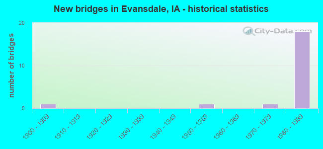
- New bridges - historical statistics
- 11900-1909
- 11950-1959
- 11970-1979
- 181980-1989


- Bridge Condition - Deck
- 9.1%Very good
- 27.3%Good
- 54.5%Satisfactory
- 9.1%Fair

- Bridge Condition - Superstructure
- 36.4%Very good
- 36.4%Good
- 27.3%Satisfactory

- Bridge Condition - Substructure
- 9.1%Very good
- 72.7%Good
- 9.1%Satisfactory
- 9.1%Poor

- Bridge Condition - Channel
- 25.0%Very good
- 50.0%Good
- 25.0%Satisfactory
Find on map >> Show street view
Structure Number: 463, Location: 000000000 (Lat: 42.461178, Lng: -92.279594), Route carried "on" structure: City street , Year Built: 1900, Status: Posted for load, Structure Length: 3.08m (10.10ft), Average Daily Traffic: 250 (year 1997), Average Future Daily Traffic: 250 (year 2040), Features Intersected: ELK RUN CREEK, Facility Carried by Structure: 6TH ST
Minimum Vertical Clearance: 30+ m (98+ ft), Kilometerpoint: 0.098, Lanes on structure: 2, Owner: City or Municipal Highway Agency, Approaching Roadway Width: 7.3m (24.0ft), Material/Design: Steel, Design/Construction: Stringer/Multi-beam, Number Of Spans In Main Unit: 3, Length of Maximum Span: 10.4m (34.1ft), Curb-To-Curb Width: 5.5m (18.0ft), Out-to-Out Width: 6.3m (20.7ft)
Condition: Deck: Satisfactory, Superstructure: Satisfactory, Substructure: Poor, Channel: Satisfactory, Operating Rating: 25.5 metric tons, Method Used To Determine Operating Rating: Load Factor (LF), Inventory Rating: 15.2 metric tons, Method Used To Determine Inventory Rating: Load Factor (LF), Structural Evaluation: Meets minimum limits, Deck Geometry: High priority of corrective action, Waterway Adequacy: Equal to present minimum criteria, Approach Roadway Alignment: Better than present minimum criteria, Bridge Posting: Required (Relationship of Operating Rating to Maximum Legal Load: 20.0 - 29.9% below), Length Of Structure Improvement: 13.00m (42.65ft), Designated Inspection Frequency: Every 24 months, Inspection Date: August 2020, Bridge Improvement Cost: $260,000, Roadway Improvement Cost: $26,000, Deck Structure Type: Wood or Timber
Find on map >> Show street view
Structure Number: 1464, Location: 000000000 (Lat: 42.472872, Lng: -92.262181), Route carried "on" structure: City street , Year Built: 1958, Status: Open, Structure Length: 5.61m (18.41ft), Average Daily Traffic: 2,425 (year 2021), Average Future Daily Traffic: 2,425 (year 2040), Design Load: H 20, Features Intersected: ELK RUN CREEK, Facility Carried by Structure: DUBUQUE RD EAST
Minimum Vertical Clearance: 30+ m (98+ ft), Kilometerpoint: 2.850, Lanes on structure: 2, Base Highway Network: Yes, Owner: City or Municipal Highway Agency, Approaching Roadway Width: 12.2m (40.0ft), Skew: 10 degrees, Material/Design: Concrete continuous, Design/Construction: Tee Beam, Number Of Spans In Main Unit: 3, Length of Maximum Span: 22.3m (73.2ft), Curb or Sidewalk Widths: Left: 0.6m (2.0ft), Right: 0.6m (2.0ft), Curb-To-Curb Width: 8.5m (27.9ft), Out-to-Out Width: 10.5m (34.4ft)
Condition: Deck: Satisfactory, Superstructure: Satisfactory, Substructure: Satisfactory, Channel: Good, Operating Rating: 37.2 metric tons, Method Used To Determine Operating Rating: Load Factor (LF), Inventory Rating: 21.8 metric tons, Method Used To Determine Inventory Rating: Load Factor (LF), Structural Evaluation: Somewhat better than minimum adequacy, Deck Geometry: High priority of corrective action, Waterway Adequacy: Better than present minimum criteria, Approach Roadway Alignment: Equal to present desirable criteria, Length Of Structure Improvement: 22.00m (72.18ft), Designated Inspection Frequency: Every 24 months, Other Special Inspection Frequency: Every 12 months, Inspection Date: August 2020, Other Special Inspection Date: September 2014, Bridge Improvement Cost: $370,000, Roadway Improvement Cost: $70,000, Deck Structure Type: Concrete Cast-file-Place, Wearing Surface/Protective System: Wearing Surface: Low Slump Concrete
Find on map >> Show street view
Structure Number: 7505, Location: 88-12-10-04-10 (Lat: 42.447000, Lng: -92.232547), Route carried "on" structure: County highway , Year Built: 1975, Status: Open, Structure Length: 1.80m (5.91ft), Average Daily Traffic: 830 (year 2021), Average Future Daily Traffic: 830 (year 2038), Design Load: HS 20, Features Intersected: POYNER CREEK, Facility Carried by Structure: GILBERTVILLE RD
Minimum Vertical Clearance: 30+ m (98+ ft), Kilometerpoint: 8.671, Lanes on structure: 2, Owner: County Highway Agency, Approaching Roadway Width: 11.6m (38.1ft), Skew: 3 degrees, Material/Design: Concrete continuous, Design/Construction: Culvert, Number Of Spans In Main Unit: 3, Length of Maximum Span: 6.4m (21.0ft)
Condition: Channel: Very good, Culverts: Good, Operating Rating: 44.1 metric tons, Method Used To Determine Operating Rating: Load Factor (LF), Inventory Rating: 32.7 metric tons, Method Used To Determine Inventory Rating: Load Factor (LF), Structural Evaluation: Better than present minimum criteria, Waterway Adequacy: Better than present minimum criteria, Approach Roadway Alignment: Better than present minimum criteria, Designated Inspection Frequency: Every 48 months, Inspection Date: March 2018
Find on map >> Show street view
Structure Number: 363095, Location: 88-12-09-04-10 (Lat: 42.457436, Lng: -92.244636), Route carried "on" structure: City street , Year Built: 1988, Status: Open, Structure Length: 0.67m (2.20ft), Average Daily Traffic: 1,530 (year 2001), Average Future Daily Traffic: 1,530 (year 2038), Design Load: HS 20, Features Intersected: TRIB TO CEDAR RIVER, Facility Carried by Structure: GILBERTVILLE RD
Minimum Vertical Clearance: 30+ m (98+ ft), Kilometerpoint: 0.010, Lanes on structure: 2, Owner: County Highway Agency, Approaching Roadway Width: 13.4m (44.0ft), Skew: 13 degrees, Material/Design: Concrete continuous, Design/Construction: Culvert, Number Of Spans In Main Unit: 2, Length of Maximum Span: 3.0m (9.8ft)
Condition: Channel: Very good, Culverts: Good, Operating Rating: 61.0 metric tons, Method Used To Determine Operating Rating: Load Factor (LF), Inventory Rating: 36.5 metric tons, Method Used To Determine Inventory Rating: Load Factor (LF), Structural Evaluation: Better than present minimum criteria, Waterway Adequacy: Better than present minimum criteria, Approach Roadway Alignment: Better than present minimum criteria, Designated Inspection Frequency: Every 48 months, Inspection Date: March 2018
Find on map >> Show street view
Structure Number: 50345, Location: 0.8 MI. S OF S JCT. 218 (Lat: 42.459228, Lng: -92.297808), Route carried "on" structure: Interstate 380, Year Built: 1981, Status: Open, Structure Length: 9.36m (30.71ft), Average Daily Traffic: 260 (year 2020), Truck Traffic: 12%, Average Future Daily Traffic: 260 (year 2041), Design Load: HS 20, Features Intersected: I-380, Facility Carried by Structure: RIVER FOREST RD
Minimum Vertical Clearance: 30+ m (98+ ft), Kilometerpoint: 0.151, Lanes on structure: 2, Lanes under structure: 5, Owner: State Highway Agency, Approaching Roadway Width: 14.6m (47.9ft), Skew: 1 degrees, Material/Design: Prestressed concrete, Design/Construction: Stringer/Multi-beam, Number Of Spans In Main Unit: 4, Length of Maximum Span: 29.3m (96.1ft), Curb-To-Curb Width: 14.0m (45.9ft), Out-to-Out Width: 15.6m (51.2ft)
Condition: Deck: Satisfactory, Superstructure: Good, Substructure: Good, Operating Rating: 72.1 metric tons, Method Used To Determine Operating Rating: Load Factor (LF), Inventory Rating: 32.1 metric tons, Method Used To Determine Inventory Rating: Load Factor (LF), Structural Evaluation: Better than present minimum criteria, Deck Geometry: Superior to present desirable criteria, Underclear: Equal to present minimum criteria, Approach Roadway Alignment: Meets minimum limits, Designated Inspection Frequency: Every 24 months, Inspection Date: October 2021, Deck Structure Type: Concrete Cast-file-Place, Wearing Surface/Protective System: Wearing Surface: Monolithic Concrete, Deck Protection: Epoxy Coated Reinforcing
Find on map >> Show street view
Structure Number: 50375, Location: 000000000 (Lat: 42.463819, Lng: -92.278436), Route carried "on" structure: City street , Year Built: 1983, Status: Open, Structure Length: 6.64m (21.78ft), Average Daily Traffic: 2,010 (year 2021), Average Future Daily Traffic: 2,010 (year 2040), Design Load: HS 20, Features Intersected: ELK RUN CREEK, Facility Carried by Structure: GILBERT DR
Minimum Vertical Clearance: 30+ m (98+ ft), Kilometerpoint: 1.648, Lanes on structure: 2, Owner: City or Municipal Highway Agency, Approaching Roadway Width: 9.1m (29.9ft), Material/Design: Prestressed concrete, Design/Construction: Stringer/Multi-beam, Number Of Spans In Main Unit: 3, Length of Maximum Span: 24.7m (81.0ft), Curb or Sidewalk Widths: Left: 1.5m (4.9ft), Right: 1.5m (4.9ft), Curb-To-Curb Width: 9.1m (29.9ft), Out-to-Out Width: 13.7m (44.9ft)
Condition: Deck: Very good, Superstructure: Very good, Substructure: Good, Channel: Good, Operating Rating: 77.1 metric tons, Method Used To Determine Operating Rating: Load Factor (LF), Inventory Rating: 46.2 metric tons, Method Used To Determine Inventory Rating: Load Factor (LF), Structural Evaluation: Better than present minimum criteria, Deck Geometry: Meets minimum limits, Waterway Adequacy: Equal to present desirable criteria, Approach Roadway Alignment: Better than present minimum criteria, Designated Inspection Frequency: Every 24 months, Inspection Date: August 2020, Deck Structure Type: Concrete Cast-file-Place, Wearing Surface/Protective System: Wearing Surface: Monolithic Concrete, Deck Protection: Epoxy Coated Reinforcing
Find on map >> Show street view
Structure Number: 60524, Location: 1.2 MI. N OF JCT. SR V49 (Lat: 42.450831, Lng: -92.236903), Route carried "on" structure: County highway , Year Built: 1982, Status: Open, Structure Length: 12.50m (41.01ft), Average Daily Traffic: 830 (year 2021), Average Future Daily Traffic: 830 (year 2040), Design Load: HS 20, Features Intersected: I-380, Facility Carried by Structure: GILBERTVILLE RD
Minimum Vertical Clearance: 30+ m (98+ ft), Kilometerpoint: 9.228, Lanes on structure: 2, Lanes under structure: 4, Owner: State Highway Agency, Approaching Roadway Width: 12.2m (40.0ft), Skew: 4 degrees, Material/Design: Steel, Design/Construction: Stringer/Multi-beam, Number Of Spans In Main Unit: 4, Length of Maximum Span: 39.9m (130.9ft), Curb-To-Curb Width: 9.7m (31.8ft), Out-to-Out Width: 10.7m (35.1ft)
Condition: Deck: Fair, Superstructure: Good, Substructure: Good, Operating Rating: 52.9 metric tons, Method Used To Determine Operating Rating: Load Factor (LF), Inventory Rating: 31.7 metric tons, Method Used To Determine Inventory Rating: Load Factor (LF), Structural Evaluation: Better than present minimum criteria, Deck Geometry: Equal to present minimum criteria, Underclear: Superior to present desirable criteria, Approach Roadway Alignment: Equal to present minimum criteria, Designated Inspection Frequency: Every 24 months, Inspection Date: June 2020, Deck Structure Type: Concrete Cast-file-Place, Wearing Surface/Protective System: Wearing Surface: Epoxy Overlay, Deck Protection: Epoxy Coated Reinforcing
Find on map >> Show street view
Structure Number: 605245, Location: AT JCT. OF EVANSDALE DR. (Lat: 42.457428, Lng: -92.254550), Route carried "on" structure: City street , Year Built: 1982, Status: Open, Structure Length: 8.17m (26.80ft), Average Daily Traffic: 4,490 (year 2021), Average Future Daily Traffic: 4,490 (year 2041), Design Load: HS 20, Features Intersected: I-380, Facility Carried by Structure: EVANSDALE DR
Minimum Vertical Clearance: 30+ m (98+ ft), Kilometerpoint: 0.808, Lanes on structure: 4, Lanes under structure: 4, Owner: State Highway Agency, Approaching Roadway Width: 20.7m (67.9ft), Skew: 1 degrees, Material/Design: Prestressed concrete, Design/Construction: Stringer/Multi-beam, Number Of Spans In Main Unit: 4, Length of Maximum Span: 28.0m (91.9ft), Curb-To-Curb Width: 17.1m (56.1ft), Out-to-Out Width: 18.0m (59.1ft)
Condition: Deck: Satisfactory, Superstructure: Very good, Substructure: Good, Operating Rating: 87.5 metric tons, Method Used To Determine Operating Rating: Load Factor (LF), Inventory Rating: 34.7 metric tons, Method Used To Determine Inventory Rating: Load Factor (LF), Structural Evaluation: Better than present minimum criteria, Deck Geometry: Somewhat better than minimum adequacy, Underclear: Equal to present minimum criteria, Approach Roadway Alignment: Somewhat better than minimum adequacy, Designated Inspection Frequency: Every 24 months, Inspection Date: October 2021, Deck Structure Type: Concrete Cast-file-Place, Wearing Surface/Protective System: Wearing Surface: Monolithic Concrete, Deck Protection: Epoxy Coated Reinforcing
Find on map >> Show street view
Structure Number: 60525, Location: 2.6 MI. S OF JCT. US 218 (Lat: 42.460361, Lng: -92.263275), Route carried "on" structure: Interstate 380, Year Built: 1983, Status: Open, Structure Length: 4.45m (14.60ft), Average Daily Traffic: 14,250 (year 2020), Truck Traffic: 22%, Average Future Daily Traffic: 14,250 (year 2041), Design Load: HS 20, Features Intersected: MCCOY RD
Minimum Vertical Clearance: 30+ m (98+ ft), Kilometerpoint: 110.892, Lanes on structure: 2, Lanes under structure: 2, Base Highway Network: Yes, Owner: State Highway Agency, Approaching Roadway Width: 12.2m (40.0ft), Material/Design: Prestressed concrete, Design/Construction: Stringer/Multi-beam, Number Of Spans In Main Unit: 3, Length of Maximum Span: 22.3m (73.2ft), Curb-To-Curb Width: 12.2m (40.0ft), Out-to-Out Width: 13.2m (43.3ft)
Condition: Deck: Good, Superstructure: Good, Substructure: Good, Operating Rating: 79.2 metric tons, Method Used To Determine Operating Rating: Load Factor (LF), Inventory Rating: 33.2 metric tons, Method Used To Determine Inventory Rating: Load Factor (LF), Structural Evaluation: Better than present minimum criteria, Deck Geometry: Better than present minimum criteria, Underclear: Equal to present minimum criteria, Approach Roadway Alignment: Better than present minimum criteria, Designated Inspection Frequency: Every 24 months, Inspection Date: October 2021, Deck Structure Type: Concrete Cast-file-Place, Wearing Surface/Protective System: Wearing Surface: Monolithic Concrete, Deck Protection: Epoxy Coated Reinforcing
Find on map >> Show street view
Structure Number: 605255, Location: 2.6 MI. S OF JCT. US 218 (Lat: 42.460150, Lng: -92.263750), Route carried "on" structure: Interstate 380, Year Built: 1983, Status: Open, Structure Length: 4.45m (14.60ft), Average Daily Traffic: 14,250 (year 2020), Truck Traffic: 22%, Average Future Daily Traffic: 14,250 (year 2041), Design Load: HS 20, Features Intersected: MCCOY RD
Minimum Vertical Clearance: 30+ m (98+ ft), Kilometerpoint: 6.859, Lanes on structure: 2, Lanes under structure: 2, Owner: State Highway Agency, Approaching Roadway Width: 12.2m (40.0ft), Material/Design: Prestressed concrete, Design/Construction: Stringer/Multi-beam, Number Of Spans In Main Unit: 3, Length of Maximum Span: 22.3m (73.2ft), Curb-To-Curb Width: 12.2m (40.0ft), Out-to-Out Width: 13.2m (43.3ft)
Condition: Deck: Good, Superstructure: Very good, Substructure: Very good, Operating Rating: 77.5 metric tons, Method Used To Determine Operating Rating: Load Factor (LF), Inventory Rating: 30.2 metric tons, Method Used To Determine Inventory Rating: Load Factor (LF), Structural Evaluation: Better than present minimum criteria, Deck Geometry: Better than present minimum criteria, Underclear: High priority of corrective action, Approach Roadway Alignment: Better than present minimum criteria, Designated Inspection Frequency: Every 24 months, Inspection Date: October 2021, Deck Structure Type: Concrete Cast-file-Place, Wearing Surface/Protective System: Wearing Surface: Monolithic Concrete, Deck Protection: Epoxy Coated Reinforcing
Find on map >> Show street view
Structure Number: 60526, Location: 1.9 MI S OF S JCT. US 218 (Lat: 42.460600, Lng: -92.278153), Route carried "on" structure: Interstate 380, Year Built: 1983, Status: Open, Structure Length: 10.52m (34.51ft), Average Daily Traffic: 14,250 (year 2020), Truck Traffic: 22%, Average Future Daily Traffic: 14,250 (year 2041), Design Load: HS 20, Features Intersected: ELK RUN CREEK & RD
Minimum Vertical Clearance: 30+ m (98+ ft), Kilometerpoint: 112.115, Lanes on structure: 2, Lanes under structure: 2, Base Highway Network: Yes, Owner: State Highway Agency, Approaching Roadway Width: 12.2m (40.0ft), Skew: 4 degrees, Material/Design: Prestressed concrete, Design/Construction: Stringer/Multi-beam, Number Of Spans In Main Unit: 4, Length of Maximum Span: 28.0m (91.9ft), Curb-To-Curb Width: 12.2m (40.0ft), Out-to-Out Width: 13.2m (43.3ft)
Condition: Deck: Good, Superstructure: Good, Substructure: Good, Channel: Good, Operating Rating: 73.5 metric tons, Method Used To Determine Operating Rating: Load Factor (LF), Inventory Rating: 39.0 metric tons, Method Used To Determine Inventory Rating: Load Factor (LF), Structural Evaluation: Better than present minimum criteria, Deck Geometry: Better than present minimum criteria, Underclear: Meets minimum limits, Waterway Adequacy: Equal to present desirable criteria, Approach Roadway Alignment: Better than present minimum criteria, Designated Inspection Frequency: Every 24 months, Inspection Date: September 2021, Deck Structure Type: Concrete Cast-file-Place, Wearing Surface/Protective System: Wearing Surface: Monolithic Concrete, Deck Protection: Epoxy Coated Reinforcing
Find on map >> Show street view
Structure Number: 605265, Location: 1.9 MI. S OF S JCT US 218 (Lat: 42.460344, Lng: -92.279428), Route carried "on" structure: Interstate 380, Year Built: 1983, Status: Open, Structure Length: 10.52m (34.51ft), Average Daily Traffic: 14,250 (year 2020), Truck Traffic: 22%, Average Future Daily Traffic: 14,250 (year 2041), Design Load: HS 20, Features Intersected: ELK RUN CREEK & RD
Minimum Vertical Clearance: 30+ m (98+ ft), Kilometerpoint: 5.568, Lanes on structure: 2, Lanes under structure: 2, Owner: State Highway Agency, Approaching Roadway Width: 12.2m (40.0ft), Skew: 4 degrees, Material/Design: Prestressed concrete, Design/Construction: Stringer/Multi-beam, Number Of Spans In Main Unit: 4, Length of Maximum Span: 28.0m (91.9ft), Curb-To-Curb Width: 12.2m (40.0ft), Out-to-Out Width: 13.2m (43.3ft)
Condition: Deck: Satisfactory, Superstructure: Very good, Substructure: Good, Channel: Good, Operating Rating: 73.5 metric tons, Method Used To Determine Operating Rating: Load Factor (LF), Inventory Rating: 44.1 metric tons, Method Used To Determine Inventory Rating: Load Factor (LF), Structural Evaluation: Better than present minimum criteria, Deck Geometry: Better than present minimum criteria, Underclear: Meets minimum limits, Waterway Adequacy: Equal to present desirable criteria, Approach Roadway Alignment: Better than present minimum criteria, Designated Inspection Frequency: Every 24 months, Inspection Date: September 2021, Deck Structure Type: Concrete Cast-file-Place, Wearing Surface/Protective System: Wearing Surface: Monolithic Concrete, Deck Protection: Epoxy Coated Reinforcing
Find on map >> Show street view
Structure Number: 605275, Location: 0.4 MI. S OF JCT. 218 (Lat: 42.457036, Lng: -92.303828), Route carried "on" structure: Interstate 380, Year Built: 1983, Status: Open, Structure Length: 46.54m (152.69ft), Average Daily Traffic: 16,900 (year 2020), Truck Traffic: 19%, Average Future Daily Traffic: 16,900 (year 2041), Design Load: HS 20, Features Intersected: IANR RR,TX ST, CEDAR RVR
Minimum Vertical Clearance: 30+ m (98+ ft), Kilometerpoint: 114.288, Lanes on structure: 2, Lanes under structure: 2, Base Highway Network: Yes, Owner: State Highway Agency, Approaching Roadway Width: 12.2m (40.0ft), Skew: 9 degrees, Material/Design: Steel continuous, Design/Construction: Stringer/Multi-beam, Number Of Spans In Main Unit: 14, Length of Maximum Span: 39.6m (129.9ft), Curb-To-Curb Width: 12.9m (42.3ft), Out-to-Out Width: 13.9m (45.6ft)
Condition: Deck: Satisfactory, Superstructure: Satisfactory, Substructure: Good, Channel: Satisfactory, Operating Rating: 58.0 metric tons, Method Used To Determine Operating Rating: Load Factor (LF), Inventory Rating: 34.7 metric tons, Method Used To Determine Inventory Rating: Load Factor (LF), Structural Evaluation: Equal to present minimum criteria, Deck Geometry: Superior to present desirable criteria, Underclear: High priority of corrective action, Waterway Adequacy: Equal to present desirable criteria, Approach Roadway Alignment: Better than present minimum criteria, Designated Inspection Frequency: Every 24 months, Underwater Inspection Frequency: Every 60 months, Inspection Date: May 2021, Underwater Inspection Date: August 2017, Deck Structure Type: Concrete Cast-file-Place, Wearing Surface/Protective System: Wearing Surface: Monolithic Concrete, Deck Protection: Epoxy Coated Reinforcing
Find on map >> Show street view
Structure Number: 50345, Location: 0.8 MI. S OF S JCT. 218 (Lat: 42.459228, Lng: -92.297808), Route carried "under" structure: Interstate 380, Year Built: 1981, Structure Length: 0. m, Average Daily Traffic: 27,900 (year 2020), Truck Traffic: 22%, Features Intersected: I-380, Facility Carried by Structure: RIVER FOREST RD
Minimum Vertical Clearance: 30+ m (98+ ft), Kilometerpoint: 113.728, Lanes on structure: 2, Lanes under structure: 5, Material/Design: Prestressed concrete, Design/Construction: Stringer/Multi-beam, Length of Maximum Span: 29.3m (96.1ft)
Find on map >> Show street view
Structure Number: 60524, Location: 1.2 MI. N OF JCT. SR V49 (Lat: 42.450831, Lng: -92.236903), Route carried "under" structure: Interstate 380, Year Built: 1982, Structure Length: 0. m, Average Daily Traffic: 25,400 (year 2020), Truck Traffic: 23%, Features Intersected: I-380, Facility Carried by Structure: GILBERTVILLE RD
Minimum Vertical Clearance: 30+ m (98+ ft), Kilometerpoint: 108.505, Lanes on structure: 2, Lanes under structure: 4, Material/Design: Steel, Design/Construction: Stringer/Multi-beam, Length of Maximum Span: 39.9m (130.9ft)
Find on map >> Show street view
Structure Number: 605245, Location: AT JCT. OF EVANSDALE DR. (Lat: 42.457428, Lng: -92.254550), Route carried "under" structure: Interstate 380, Year Built: 1982, Structure Length: 0. m, Average Daily Traffic: 22,300 (year 2020), Truck Traffic: 21%, Features Intersected: I-380, Facility Carried by Structure: EVANSDALE DR
Minimum Vertical Clearance: 30+ m (98+ ft), Kilometerpoint: 110.065, Lanes on structure: 4, Lanes under structure: 4, Material/Design: Prestressed concrete, Design/Construction: Stringer/Multi-beam, Length of Maximum Span: 28.0m (91.9ft)
Find on map >> Show street view
Structure Number: 60525, Location: 2.6 MI. S OF JCT. US 218 (Lat: 42.460361, Lng: -92.263275), Route carried "under" structure: City street , Year Built: 1983, Structure Length: 0. m, Average Daily Traffic: 840 (year 2021), Features Intersected: MCCOY RD, Facility Carried by Structure: I 380 NB
Minimum Vertical Clearance: 30+ m (98+ ft), Kilometerpoint: 0.850, Lanes on structure: 2, Lanes under structure: 2, Material/Design: Prestressed concrete, Design/Construction: Stringer/Multi-beam, Length of Maximum Span: 22.3m (73.2ft)
Find on map >> Show street view
Structure Number: 605255, Location: 2.6 MI. S OF JCT. US 218 (Lat: 42.460150, Lng: -92.263750), Route carried "under" structure: City street , Year Built: 1983, Structure Length: 0. m, Average Daily Traffic: 840 (year 2021), Features Intersected: MCCOY RD, Facility Carried by Structure: I 380 SB
Minimum Vertical Clearance: 30+ m (98+ ft), Kilometerpoint: 0.822, Lanes on structure: 2, Lanes under structure: 2, Material/Design: Prestressed concrete, Design/Construction: Stringer/Multi-beam, Length of Maximum Span: 22.3m (73.2ft)
Find on map >> Show street view
Structure Number: 60526, Location: 1.9 MI S OF S JCT. US 218 (Lat: 42.460600, Lng: -92.278153), Route carried "under" structure: City street , Year Built: 1983, Structure Length: 0. m, Average Daily Traffic: 50 (year 1989), Features Intersected: ELK RUN CREEK & RD, Facility Carried by Structure: I 380 NB
Minimum Vertical Clearance: 30+ m (98+ ft), Kilometerpoint: 1.147, Lanes on structure: 2, Lanes under structure: 2, Material/Design: Prestressed concrete, Design/Construction: Stringer/Multi-beam, Length of Maximum Span: 28.0m (91.9ft)
Find on map >> Show street view
Structure Number: 605265, Location: 1.9 MI. S OF S JCT US 218 (Lat: 42.460344, Lng: -92.279428), Route carried "under" structure: City street , Year Built: 1983, Structure Length: 0. m, Average Daily Traffic: 50 (year 1989), Features Intersected: ELK RUN CREEK & RD, Facility Carried by Structure: I 380 SB
Minimum Vertical Clearance: 30+ m (98+ ft), Kilometerpoint: 1.110, Lanes on structure: 2, Lanes under structure: 2, Material/Design: Prestressed concrete, Design/Construction: Stringer/Multi-beam, Length of Maximum Span: 28.0m (91.9ft)
Find on map >> Show street view
Structure Number: 605275, Location: 0.4 MI. S OF JCT. 218 (Lat: 42.457036, Lng: -92.303828), Route carried "under" structure: City street , Year Built: 1983, Structure Length: 0. m, Average Daily Traffic: 1,905 (year 2017), Features Intersected: IANR RR,TX ST, CEDAR RVR, Facility Carried by Structure: I 380 NB
Minimum Vertical Clearance: 30+ m (98+ ft), Kilometerpoint: 2.147, Lanes on structure: 2, Lanes under structure: 2, Material/Design: Steel continuous, Design/Construction: Stringer/Multi-beam, Length of Maximum Span: 39.6m (129.9ft)