Bridge Statistics for Evanston, Illinois (IL)
Condition, Traffic, Stress, Structural Evaluation, Project Costs
- National Bridge Inventory (NBI) Statistics
- 24Number of bridges
- 164ft / 50.3mTotal length
- $6,224,000Total costs
- 201,000Total average daily traffic
- 8,744Total average daily truck traffic
- National Bridge Inventory (NBI) Registered Bridges for Evanston
- No street view available for this location
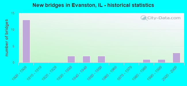
- New bridges - historical statistics
- 131900-1909
- 21930-1939
- 21940-1949
- 21950-1959
- 11980-1989
- 11990-1999
- 32000-2009
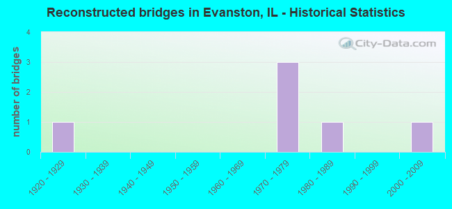
- Reconstructed bridges - Historical Statistics
- 11920-1929
- 01930-1939
- 01940-1949
- 01950-1959
- 01960-1969
- 31970-1979
- 11980-1989
- 01990-1999
- 12000-2009
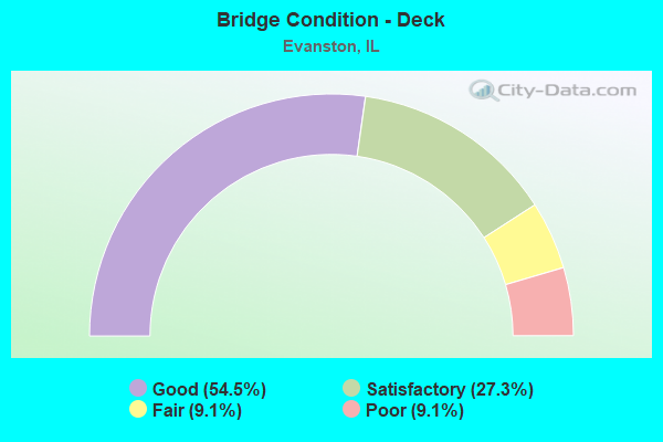
- Bridge Condition - Deck
- 54.5%Good
- 27.3%Satisfactory
- 9.1%Fair
- 9.1%Poor

- Bridge Condition - Superstructure
- 18.2%Very good
- 27.3%Good
- 27.3%Satisfactory
- 9.1%Fair
- 9.1%Poor
- 9.1%Serious
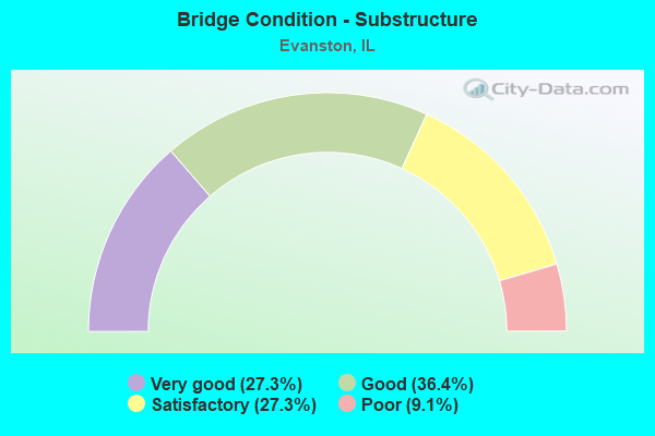
- Bridge Condition - Substructure
- 27.3%Very good
- 36.4%Good
- 27.3%Satisfactory
- 9.1%Poor
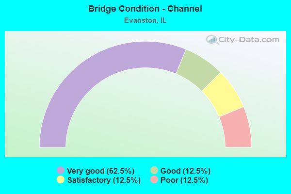
- Bridge Condition - Channel
- 62.5%Very good
- 12.5%Good
- 12.5%Satisfactory
- 12.5%Poor
Find on map >> Show street view
Structure Number: 160289, Location: 0.2 M N SIMPSON (Lat: 42.059267, Lng: -87.694553), Route carried "on" structure: Other road , Year Built: 1936, Year Reconstructed: 1989, Status: Open, Structure Length: 4.45m (14.60ft), Average Daily Traffic: 20,600 (year 2018), Truck Traffic: 5%, Average Future Daily Traffic: 21,630 (year 2032), Design Load: HS 20, Features Intersected: N SHORE CHANNEL, Facility Carried by Structure: GREEN BAY RD
Minimum Vertical Clearance: 30+ m (98+ ft), Kilometerpoint: 12.601, Lanes on structure: 5, Base Highway Network: Yes, Owner: State Highway Agency, Approaching Roadway Width: 16.5m (54.1ft), Material/Design: Steel, Design/Construction: Stringer/Multi-beam, Number Of Spans In Main Unit: 3, Length of Maximum Span: 21.3m (69.9ft), Curb or Sidewalk Widths: Left: 0.0m, Right: 1.5m (4.9ft), Curb-To-Curb Width: 16.5m (54.1ft), Out-to-Out Width: 19.0m (62.3ft)
Condition: Deck: Good, Superstructure: Fair, Substructure: Satisfactory, Channel: Very good, Operating Rating: 80.0 metric tons, Method Used To Determine Operating Rating: Load Factor (LF) rating reported by rating factor (RF) method using MS18 loading, Inventory Rating: 47.6 metric tons, Method Used To Determine Inventory Rating: Load Factor (LF) rating reported by rating factor (RF) method using MS18 loading, Structural Evaluation: Somewhat better than minimum adequacy, Deck Geometry: High priority of replacement, Waterway Adequacy: Equal to present desirable criteria, Approach Roadway Alignment: Equal to present desirable criteria, Length Of Structure Improvement: 5.33m (17.49ft), Designated Inspection Frequency: Every 24 months, Inspection Date: September 2020, Bridge Improvement Cost: $1,403,000, Roadway Improvement Cost: $140,000, Total Project Cost: $2,105,000, Deck Structure Type: Concrete Cast-file-Place, Wearing Surface/Protective System: Deck Protection: Epoxy Coated Reinforcing
Find on map >> Show street view
Structure Number: 162773, Location: 0.2 E KIMBALL (Lat: 42.040958, Lng: -87.709583), Route carried "on" structure: Other road , Year Built: 2003, Status: Open, Structure Length: 5.53m (18.14ft), Average Daily Traffic: 20,600 (year 2021), Truck Traffic: 3%, Average Future Daily Traffic: 19,055 (year 2032), Design Load: HS 20, Features Intersected: N. SHORE CHANNEL, Facility Carried by Structure: DEMPSTER ST
Minimum Vertical Clearance: 30+ m (98+ ft), Kilometerpoint: 0.097, Lanes on structure: 4, Base Highway Network: Yes, Owner: State Highway Agency, Approaching Roadway Width: 20.0m (65.6ft), Material/Design: Steel continuous, Design/Construction: Stringer/Multi-beam, Number Of Spans In Main Unit: 3, Length of Maximum Span: 26.5m (86.9ft), Curb-To-Curb Width: 20.0m (65.6ft), Out-to-Out Width: 24.8m (81.4ft)
Condition: Deck: Satisfactory, Superstructure: Good, Substructure: Good, Channel: Very good, Operating Rating: 85.2 metric tons, Method Used To Determine Operating Rating: Load Factor (LF) rating reported by rating factor (RF) method using MS18 loading, Inventory Rating: 51.2 metric tons, Method Used To Determine Inventory Rating: Load Factor (LF) rating reported by rating factor (RF) method using MS18 loading, Structural Evaluation: Better than present minimum criteria, Deck Geometry: Better than present minimum criteria, Waterway Adequacy: Superior to present desirable criteria, Approach Roadway Alignment: Equal to present desirable criteria, Designated Inspection Frequency: Every 48 months, Inspection Date: September 2021, Deck Structure Type: Concrete Cast-file-Place, Wearing Surface/Protective System: Deck Protection: Epoxy Coated Reinforcing
Find on map >> Show street view
Structure Number: 162858, Location: 0.5 M E MCCORMICK BL (Lat: 42.052403, Lng: -87.708733), Route carried "on" structure: Other road , Year Built: 2008, Status: Open, Structure Length: 6.54m (21.46ft), Average Daily Traffic: 14,200 (year 2018), Truck Traffic: 7%, Average Future Daily Traffic: 9,682 (year 2032), Design Load: HS 25 or greater, Features Intersected: N SHORE CHANNEL, Facility Carried by Structure: EMERSON AVE
Minimum Vertical Clearance: 30+ m (98+ ft), Kilometerpoint: 7.644, Lanes on structure: 4, Base Highway Network: Yes, Owner: State Highway Agency, Approaching Roadway Width: 20.4m (66.9ft), Skew: 2 degrees, Material/Design: Prestressed concrete continuous, Design/Construction: Stringer/Multi-beam, Number Of Spans In Main Unit: 3, Length of Maximum Span: 24.4m (80.1ft), Curb or Sidewalk Widths: Left: 1.7m (5.6ft), Right: 1.7m (5.6ft), Curb-To-Curb Width: 20.4m (66.9ft), Out-to-Out Width: 24.4m (80.1ft)
Condition: Deck: Good, Superstructure: Good, Substructure: Very good, Channel: Very good, Operating Rating: 58.0 metric tons, Method Used To Determine Operating Rating: Load and Resistance Factor Rating (LRFR) rating reported by rating factor(RF) method using HL-93 loadings, Inventory Rating: 44.7 metric tons, Method Used To Determine Inventory Rating: Load and Resistance Factor Rating (LRFR) rating reported by rating factor(RF) method using HL-93 loadings, Structural Evaluation: Better than present minimum criteria, Deck Geometry: Superior to present desirable criteria, Waterway Adequacy: Equal to present desirable criteria, Approach Roadway Alignment: Equal to present desirable criteria, Designated Inspection Frequency: Every 48 months, Inspection Date: October 2018, Deck Structure Type: Concrete Cast-file-Place, Wearing Surface/Protective System: Deck Protection: Epoxy Coated Reinforcing
Find on map >> Show street view
Structure Number: 16695, Location: 1 M E GREEN BAY P6 (Lat: 42.068750, Lng: -87.686394), Route carried "on" structure: Other road , Year Built: 1908, Year Reconstructed: 1977, Status: Open, Structure Length: 5.36m (17.59ft), Average Daily Traffic: 1,750 (year 2018), Truck Traffic: 3%, Average Future Daily Traffic: 2,000 (year 2036), Design Load: HS 20, Features Intersected: N SHORE CHANNEL, Facility Carried by Structure: ISABELLA ST
Minimum Vertical Clearance: 30+ m (98+ ft), Kilometerpoint: 0.338, Lanes on structure: 2, Owner: City or Municipal Highway Agency, Approaching Roadway Width: 8.5m (27.9ft), Material/Design: Prestressed concrete continuous, Design/Construction: Stringer/Multi-beam, Number Of Spans In Main Unit: 3, Length of Maximum Span: 21.6m (70.9ft), Curb or Sidewalk Widths: Left: 1.5m (4.9ft), Right: 1.5m (4.9ft), Curb-To-Curb Width: 8.5m (27.9ft), Out-to-Out Width: 12.2m (40.0ft)
Condition: Deck: Satisfactory, Superstructure: Satisfactory, Substructure: Good, Channel: Very good, Operating Rating: 78.4 metric tons, Method Used To Determine Operating Rating: Load Factor (LF) rating reported by rating factor (RF) method using MS18 loading, Inventory Rating: 39.9 metric tons, Method Used To Determine Inventory Rating: Load Factor (LF) rating reported by rating factor (RF) method using MS18 loading, Structural Evaluation: Equal to present minimum criteria, Deck Geometry: Somewhat better than minimum adequacy, Waterway Adequacy: Equal to present desirable criteria, Approach Roadway Alignment: Equal to present desirable criteria, Designated Inspection Frequency: Every 24 months, Inspection Date: November 2020, Deck Structure Type: Concrete Cast-file-Place, Wearing Surface/Protective System: Wearing Surface: Latex Concrete
Find on map >> Show street view
Structure Number: 166951, Location: 0.6 M E GREEN BAYP6 (Lat: 42.064222, Lng: -87.687528), Route carried "on" structure: Other road , Year Built: 1908, Year Reconstructed: 1975, Status: Open, Structure Length: 5.67m (18.60ft), Average Daily Traffic: 9,650 (year 2018), Truck Traffic: 4%, Average Future Daily Traffic: 10,000 (year 2036), Design Load: HS 20, Features Intersected: N SHORE CHANNEL, Facility Carried by Structure: CENTRAL ST
Minimum Vertical Clearance: 30+ m (98+ ft), Kilometerpoint: 3.299, Lanes on structure: 4, Base Highway Network: Yes, Owner: City or Municipal Highway Agency, Approaching Roadway Width: 14.9m (48.9ft), Material/Design: Steel continuous, Design/Construction: Stringer/Multi-beam, Number Of Spans In Main Unit: 3, Length of Maximum Span: 21.9m (71.9ft), Curb or Sidewalk Widths: Left: 1.5m (4.9ft), Right: 1.5m (4.9ft), Curb-To-Curb Width: 15.2m (49.9ft), Out-to-Out Width: 18.8m (61.7ft)
Condition: Deck: Poor, Superstructure: Serious, Substructure: Satisfactory, Channel: Poor, Operating Rating: 56.4 metric tons, Method Used To Determine Operating Rating: Load Factor (LF) rating reported by rating factor (RF) method using MS18 loading, Inventory Rating: 33.7 metric tons, Method Used To Determine Inventory Rating: Load Factor (LF) rating reported by rating factor (RF) method using MS18 loading, Structural Evaluation: High priority of corrective action, Deck Geometry: High priority of corrective action, Waterway Adequacy: Superior to present desirable criteria, Approach Roadway Alignment: Equal to present desirable criteria, Length Of Structure Improvement: 6.80m (22.31ft), Designated Inspection Frequency: Every 24 months, Inspection Date: September 2020, Bridge Improvement Cost: $1,489,000, Roadway Improvement Cost: $149,000, Total Project Cost: $2,234,000, Deck Structure Type: Concrete Cast-file-Place, Wearing Surface/Protective System: Wearing Surface: Bituminous
Find on map >> Show street view
Structure Number: 166952, Location: 0.5 M E GREEN BAYP6 (Lat: 42.061692, Lng: -87.680031), Route carried "on" structure: City street , Year Built: 1908, Year Reconstructed: 1977, Status: Open, Structure Length: 6.89m (22.60ft), Average Daily Traffic: 4,400 (year 2018), Truck Traffic: 8%, Average Future Daily Traffic: 5,000 (year 2036), Design Load: HS 20, Features Intersected: North Shore Channel, Facility Carried by Structure: LINCOLN ST
Minimum Vertical Clearance: 30+ m (98+ ft), Kilometerpoint: 0.370, Lanes on structure: 2, Owner: City or Municipal Highway Agency, Approaching Roadway Width: 9.1m (29.9ft), Skew: 3 degrees, Material/Design: Steel continuous, Design/Construction: Stringer/Multi-beam, Number Of Spans In Main Unit: 3, Length of Maximum Span: 25.2m (82.7ft), Curb or Sidewalk Widths: Left: 1.5m (4.9ft), Right: 1.5m (4.9ft), Curb-To-Curb Width: 8.5m (27.9ft), Out-to-Out Width: 12.2m (40.0ft)
Condition: Deck: Satisfactory, Superstructure: Poor, Substructure: Poor, Channel: Good, Operating Rating: 52.8 metric tons, Method Used To Determine Operating Rating: Load Factor (LF) rating reported by rating factor (RF) method using MS18 loading, Inventory Rating: 31.8 metric tons, Method Used To Determine Inventory Rating: Load Factor (LF) rating reported by rating factor (RF) method using MS18 loading, Structural Evaluation: Meets minimum limits, Deck Geometry: Meets minimum limits, Waterway Adequacy: Superior to present desirable criteria, Approach Roadway Alignment: Equal to present desirable criteria, Designated Inspection Frequency: Every 24 months, Other Special Inspection Frequency: Every 12 months, Inspection Date: November 2020, Other Special Inspection Date: January 2022, Deck Structure Type: Concrete Cast-file-Place
Find on map >> Show street view
Structure Number: 166953, Location: 0.5 M W GREEN BAYP6 (Lat: 42.056594, Lng: -87.701614), Route carried "on" structure: City street , Year Built: 1908, Year Reconstructed: 2014, Status: Open, Structure Length: 5.24m (17.19ft), Average Daily Traffic: 4,550 (year 2018), Truck Traffic: 4%, Average Future Daily Traffic: 2,000 (year 2036), Design Load: HS 20, Features Intersected: CHI MET SAN CANAL, Facility Carried by Structure: BRIDGE ST
Minimum Vertical Clearance: 30+ m (98+ ft), Kilometerpoint: 0.064, Lanes on structure: 2, Owner: City or Municipal Highway Agency, Approaching Roadway Width: 9.8m (32.2ft), Material/Design: Prestressed concrete continuous, Design/Construction: Stringer/Multi-beam, Number Of Spans In Main Unit: 3, Length of Maximum Span: 21.6m (70.9ft), Curb or Sidewalk Widths: Left: 2.0m (6.6ft), Right: 2.1m (6.9ft), Curb-To-Curb Width: 9.8m (32.2ft), Out-to-Out Width: 15.0m (49.2ft)
Condition: Deck: Good, Superstructure: Good, Substructure: Very good, Channel: Very good, Operating Rating: 55.4 metric tons, Method Used To Determine Operating Rating: Load Factor (LF) rating reported by rating factor (RF) method using MS18 loading, Inventory Rating: 33.0 metric tons, Method Used To Determine Inventory Rating: Load Factor (LF) rating reported by rating factor (RF) method using MS18 loading, Structural Evaluation: Better than present minimum criteria, Deck Geometry: Meets minimum limits, Waterway Adequacy: Superior to present desirable criteria, Approach Roadway Alignment: Equal to present desirable criteria, Designated Inspection Frequency: Every 48 months, Inspection Date: November 2020, Deck Structure Type: Concrete Cast-file-Place, Wearing Surface/Protective System: Deck Protection: Epoxy Coated Reinforcing
Find on map >> Show street view
Structure Number: 166956, Location: 0.18 M N HOWARD P6 (Lat: 42.021986, Lng: -87.680408), Route carried "on" structure: Other road , Year Built: 1982, Status: Open, Structure Length: 1.86m (6.10ft), Average Daily Traffic: 3,350 (year 2018), Truck Traffic: 6%, Average Future Daily Traffic: 3,000 (year 2035), Design Load: HS 20, Features Intersected: CTA SKOKIE SWIFT, Facility Carried by Structure: CUSTER AVE
Minimum Vertical Clearance: 30+ m (98+ ft), Kilometerpoint: 0.499, Lanes on structure: 4, Owner: City or Municipal Highway Agency, Approaching Roadway Width: 14.0m (45.9ft), Material/Design: Steel, Design/Construction: Stringer/Multi-beam, Number Of Spans In Main Unit: 1, Length of Maximum Span: 18.6m (61.0ft), Curb or Sidewalk Widths: Left: 2.7m (8.9ft), Right: 2.7m (8.9ft), Curb-To-Curb Width: 14.0m (45.9ft), Out-to-Out Width: 19.8m (65.0ft)
Condition: Deck: Fair, Superstructure: Satisfactory, Substructure: Good, Operating Rating: 58.0 metric tons, Method Used To Determine Operating Rating: Load Factor (LF) rating reported by rating factor (RF) method using MS18 loading, Inventory Rating: 34.7 metric tons, Method Used To Determine Inventory Rating: Load Factor (LF) rating reported by rating factor (RF) method using MS18 loading, Structural Evaluation: Equal to present minimum criteria, Deck Geometry: High priority of replacement, Underclear: High priority of replacement, Approach Roadway Alignment: Equal to present desirable criteria, Length Of Structure Improvement: 2.59m (8.50ft), Designated Inspection Frequency: Every 24 months, Inspection Date: January 2022, Bridge Improvement Cost: $419,000, Roadway Improvement Cost: $42,000, Total Project Cost: $629,000, Deck Structure Type: Other, Wearing Surface/Protective System: Wearing Surface: Bituminous
Find on map >> Show street view
Structure Number: 166957, Location: 0.18 M N HOWARD (Lat: 42.022011, Lng: -87.684933), Route carried "on" structure: Other road , Year Built: 1995, Status: Open, Structure Length: 1.92m (6.30ft), Average Daily Traffic: 13,600 (year 2021), Truck Traffic: 2%, Average Future Daily Traffic: 18,000 (year 2035), Design Load: HS 20, Features Intersected: CTA SKOKIE SWIFT, Facility Carried by Structure: RIDGE AVENUE
Minimum Vertical Clearance: 30+ m (98+ ft), Kilometerpoint: 16.914, Lanes on structure: 4, Base Highway Network: Yes, Owner: City or Municipal Highway Agency, Approaching Roadway Width: 13.4m (44.0ft), Material/Design: Steel, Design/Construction: Stringer/Multi-beam, Number Of Spans In Main Unit: 1, Length of Maximum Span: 17.7m (58.1ft), Curb or Sidewalk Widths: Left: 4.1m (13.5ft), Right: 4.1m (13.5ft), Curb-To-Curb Width: 13.4m (44.0ft), Out-to-Out Width: 22.3m (73.2ft)
Condition: Deck: Good, Superstructure: Very good, Substructure: Good, Operating Rating: 51.5 metric tons, Method Used To Determine Operating Rating: Load Factor (LF) rating reported by rating factor (RF) method using MS18 loading, Inventory Rating: 30.8 metric tons, Method Used To Determine Inventory Rating: Load Factor (LF) rating reported by rating factor (RF) method using MS18 loading, Structural Evaluation: Better than present minimum criteria, Deck Geometry: High priority of replacement, Underclear: High priority of corrective action, Approach Roadway Alignment: Better than present minimum criteria, Designated Inspection Frequency: Every 48 months, Inspection Date: January 2022, Deck Structure Type: Concrete Cast-file-Place, Wearing Surface/Protective System: Wearing Surface: Bituminous, Membrane: Built-up, Deck Protection: Epoxy Coated Reinforcing
Find on map >> Show street view
Structure Number: 166959, Location: 0.2 MI N HOWARD (Lat: 42.022314, Lng: -87.690131), Route carried "on" structure: Other road , Year Built: 2006, Status: Open, Structure Length: 2.03m (6.66ft), Average Daily Traffic: 12,000 (year 2018), Truck Traffic: 3%, Average Future Daily Traffic: 12,000 (year 2035), Design Load: HS 20, Features Intersected: CTA SKOKIE SWFT, Facility Carried by Structure: ASBURY AV
Minimum Vertical Clearance: 30+ m (98+ ft), Kilometerpoint: 3.492, Lanes on structure: 4, Base Highway Network: Yes, Owner: City or Municipal Highway Agency, Approaching Roadway Width: 13.7m (44.9ft), Material/Design: Steel, Design/Construction: Stringer/Multi-beam, Number Of Spans In Main Unit: 1, Length of Maximum Span: 18.5m (60.7ft), Curb or Sidewalk Widths: Left: 2.7m (8.9ft), Right: 2.7m (8.9ft), Curb-To-Curb Width: 15.8m (51.8ft), Out-to-Out Width: 21.9m (71.9ft)
Condition: Deck: Good, Superstructure: Very good, Substructure: Very good, Operating Rating: 44.1 metric tons, Method Used To Determine Operating Rating: Assigned rating based on Load Factor Design (LFD) reported by rating factor (RF) using MS18 loading, Inventory Rating: 32.4 metric tons, Method Used To Determine Inventory Rating: Assigned rating based on Load Factor Design (LFD) reported by rating factor (RF) using MS18 loading, Structural Evaluation: Equal to present desirable criteria, Deck Geometry: Meets minimum limits, Underclear: High priority of corrective action, Approach Roadway Alignment: Equal to present desirable criteria, Designated Inspection Frequency: Every 48 months, Inspection Date: January 2022, Deck Structure Type: Other, Wearing Surface/Protective System: Deck Protection: Epoxy Coated Reinforcing
Find on map >> Show street view
Structure Number: 169709, Location: EVANSTON P6 (Lat: 42.048211, Lng: -87.709594), Route carried "on" structure: Other road , Year Built: 1909, Year Reconstructed: 1929, Status: Open, Structure Length: 4.82m (15.81ft), Average Daily Traffic: 7,250 (year 2021), Truck Traffic: 4%, Average Future Daily Traffic: 9,064 (year 2032), Design Load: H 15, Features Intersected: N SHORE CHANNEL, Facility Carried by Structure: CHURCH ST
Minimum Vertical Clearance: 30+ m (98+ ft), Kilometerpoint: 9.720, Lanes on structure: 4, Owner: Local Agency, Approaching Roadway Width: 13.4m (44.0ft), Material/Design: Steel continuous, Design/Construction: Stringer/Multi-beam, Number Of Spans In Main Unit: 3, Length of Maximum Span: 21.6m (70.9ft), Curb or Sidewalk Widths: Left: 1.8m (5.9ft), Right: 1.8m (5.9ft), Curb-To-Curb Width: 13.5m (44.3ft), Out-to-Out Width: 18.3m (60.0ft)
Condition: Deck: Good, Superstructure: Satisfactory, Substructure: Satisfactory, Channel: Satisfactory, Operating Rating: 87.2 metric tons, Method Used To Determine Operating Rating: Allowable Stress (AS) rating reported by rating factor (RF) method using MS18 loading, Inventory Rating: 47.0 metric tons, Method Used To Determine Inventory Rating: Allowable Stress (AS) rating reported by rating factor (RF) method using MS18 loading, Structural Evaluation: Equal to present minimum criteria, Deck Geometry: High priority of replacement, Waterway Adequacy: Superior to present desirable criteria, Approach Roadway Alignment: Equal to present desirable criteria, Length Of Structure Improvement: 5.79m (19.00ft), Designated Inspection Frequency: Every 24 months, Critical Feature Inspection Frequency: Every 24 months, Inspection Date: December 2021, Critical Feature Inspection Date: December 2021, Bridge Improvement Cost: $837,000, Roadway Improvement Cost: $84,000, Total Project Cost: $1,256,000, Deck Structure Type: Concrete Cast-file-Place, Wearing Surface/Protective System: Deck Protection: Epoxy Coated Reinforcing
Find on map >> Show street view
Structure Number: 160358, Location: 0.5 W SHERIDAN P6 (Lat: 42.041200, Lng: -87.682875), Route carried "under" structure: Other road , Year Built: 1900, Structure Length: 0. m, Average Daily Traffic: 525 (year 2018), Truck Traffic: 13%, Features Intersected: DEMPSTER ST, Facility Carried by Structure: C&NW RR (WEST)
Minimum Vertical Clearance: 3.61m (11.84ft), Kilometerpoint: 2.269, Lanes under structure: 4, Material/Design: Steel, Length of Maximum Span: 6.7m (22.0ft)
Find on map >> Show street view
Structure Number: 160359, Location: 0.5 W SHERIDAN P6 (Lat: 42.041200, Lng: -87.682136), Route carried "under" structure: Other road , Year Built: 1900, Structure Length: 0. m, Average Daily Traffic: 525 (year 2018), Truck Traffic: 13%, Features Intersected: DEMPSTER ST, Facility Carried by Structure: CTA (EAST)
Minimum Vertical Clearance: 3.61m (11.84ft), Kilometerpoint: 2.285, Lanes under structure: 4, Material/Design: Steel, Length of Maximum Span: 6.7m (22.0ft)
Find on map >> Show street view
Structure Number: 160657, Location: 0.9 M W LAKE MCH P6 (Lat: 42.052156, Lng: -87.688297), Route carried "under" structure: Other road , Year Built: 1954, Structure Length: 0. m, Average Daily Traffic: 1,650 (year 2018), Truck Traffic: 7%, Features Intersected: EMERSON RD&RIDGE AVE, Facility Carried by Structure: C&NW RR
Minimum Vertical Clearance: 4.24m (13.91ft), Kilometerpoint: 9.302, Lanes under structure: 4, Material/Design: Steel, Design/Construction: Girder and Floorbeam System, Length of Maximum Span: 35.1m (115.2ft)
Find on map >> Show street view
Structure Number: 160657, Location: 0.9 M W LAKE MCH P6 (Lat: 42.051764, Lng: -87.687850), Route carried "under" structure: Other road , Year Built: 1954, Structure Length: 0. m, Average Daily Traffic: 10,550 (year 2018), Truck Traffic: 5%, Features Intersected: EMERSON RD&RIDGE AVE, Facility Carried by Structure: C&NW RR
Minimum Vertical Clearance: 4.24m (13.91ft), Kilometerpoint: 14.114, Lanes under structure: 4, Material/Design: Steel, Design/Construction: Girder and Floorbeam System, Length of Maximum Span: 35.1m (115.2ft)
Find on map >> Show street view
Structure Number: 160658, Location: 0.6 M W LAKE MCH P6 (Lat: 42.052100, Lng: -87.683989), Route carried "under" structure: Other road , Year Built: 1900, Structure Length: 0. m, Average Daily Traffic: 1,650 (year 2018), Truck Traffic: 7%, Features Intersected: EMERSON RD, Facility Carried by Structure: ABANDONED NS RR
Minimum Vertical Clearance: 4.14m (13.58ft), Kilometerpoint: 9.672, Lanes under structure: 4, Material/Design: Steel, Length of Maximum Span: 14.0m (45.9ft)
Find on map >> Show street view
Structure Number: 16303, Location: CLARK&HOWARD P1C,6 (Lat: 42.019414, Lng: -87.676861), Route carried "under" structure: Other road , Year Built: 1900, Structure Length: 0. m, Average Daily Traffic: 16,000 (year 2018), Truck Traffic: 6%, Features Intersected: HOWARD ST, Facility Carried by Structure: CN&W RR
Minimum Vertical Clearance: 3.63m (11.91ft), Kilometerpoint: 12.730, Lanes under structure: 4, Material/Design: Concrete, Length of Maximum Span: 5.5m (18.0ft)
Find on map >> Show street view
Structure Number: 169902, Location: 3 M E I94 P6 (Lat: 42.064317, Lng: -87.698361), Route carried "under" structure: Other road , Year Built: 1949, Structure Length: 0. m, Average Daily Traffic: 9,650 (year 2018), Truck Traffic: 4%, Features Intersected: CENTRAL ST, Facility Carried by Structure: C&NW RR
Minimum Vertical Clearance: 3.94m (12.93ft), Kilometerpoint: 2.398, Lanes under structure: 2, Material/Design: Steel, Length of Maximum Span: 7.9m (25.9ft)
Find on map >> Show street view
Structure Number: 169903, Location: 3.6 M E I94 P6 (Lat: 42.064211, Lng: -87.686106), Route carried "under" structure: Other road , Year Built: 1949, Structure Length: 0. m, Average Daily Traffic: 9,650 (year 2018), Truck Traffic: 4%, Features Intersected: CENTRAL ST, Facility Carried by Structure: CTA ELEVATED
Minimum Vertical Clearance: 4.42m (14.50ft), Kilometerpoint: 3.428, Lanes under structure: 4, Material/Design: Steel, Length of Maximum Span: 26.2m (86.0ft)
Find on map >> Show street view
Structure Number: 169905, Location: 1.2 M E N SHOR CH P6 (Lat: 42.048497, Lng: -87.685900), Route carried "under" structure: Other road , Year Built: 1900, Structure Length: 0. m, Average Daily Traffic: 7,250 (year 2021), Truck Traffic: 4%, Features Intersected: CHURCH ST, Facility Carried by Structure: C&NW RR
Minimum Vertical Clearance: 3.94m (12.93ft), Kilometerpoint: 11.764, Lanes under structure: 4, Material/Design: Steel, Length of Maximum Span: 7.3m (24.0ft)
Find on map >> Show street view
Structure Number: 169906, Location: 1.21 E N SHORE CH P6 (Lat: 42.048497, Lng: -87.685775), Route carried "under" structure: Other road , Year Built: 1900, Structure Length: 0. m, Average Daily Traffic: 7,250 (year 2021), Truck Traffic: 4%, Features Intersected: CHURCH ST, Facility Carried by Structure: C&NW RR
Minimum Vertical Clearance: 3.94m (12.93ft), Kilometerpoint: 11.780, Lanes under structure: 4, Material/Design: Steel, Length of Maximum Span: 7.3m (24.0ft)
Find on map >> Show street view
Structure Number: 169907, Location: 3.3 M E US 41 P6 (Lat: 42.048500, Lng: -87.684761), Route carried "under" structure: Other road , Year Built: 1900, Structure Length: 0. m, Average Daily Traffic: 7,250 (year 2021), Truck Traffic: 4%, Features Intersected: CHURCH ST, Facility Carried by Structure: CTA ELEVATED
Minimum Vertical Clearance: 4.65m (15.26ft), Kilometerpoint: 11.893, Lanes under structure: 2, Material/Design: Steel, Length of Maximum Span: 6.7m (22.0ft)
Find on map >> Show street view
Structure Number: 169908, Location: 3.5 M E US 41 P6 (Lat: 42.027253, Lng: -87.678758), Route carried "under" structure: Other road , Year Built: 1909, Structure Length: 0. m, Average Daily Traffic: 8,550 (year 2018), Truck Traffic: 3%, Features Intersected: SOUTH BLVD, Facility Carried by Structure: SKOKIE SWIFT
Minimum Vertical Clearance: 3.81m (12.50ft), Kilometerpoint: 10.348, Lanes under structure: 4, Material/Design: Steel, Length of Maximum Span: 6.7m (22.0ft)
Find on map >> Show street view
Structure Number: 169909, Location: 3.51 M E US 41 P6 (Lat: 42.027256, Lng: -87.678561), Route carried "under" structure: Other road , Year Built: 1939, Structure Length: 0. m, Average Daily Traffic: 8,550 (year 2018), Truck Traffic: 3%, Features Intersected: SOUTH BLVD, Facility Carried by Structure: C&NW RR SPUR
Minimum Vertical Clearance: 4.17m (13.68ft), Kilometerpoint: 10.364, Lanes under structure: 4, Material/Design: Steel, Length of Maximum Span: 6.7m (22.0ft)