Bridge Statistics for Everest, Kansas (KS)
Condition, Traffic, Stress, Structural Evaluation, Project Costs
- National Bridge Inventory (NBI) Statistics
- 11Number of bridges
- 56ft / 17.4mTotal length
- $272,000Total costs
- 549Total average daily traffic
- 12Total average daily truck traffic
- 671Total future (year 2040) average daily traffic
- National Bridge Inventory (NBI) Registered Bridges for Everest
- No street view available for this location
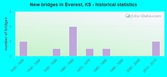
- New bridges - historical statistics
- 21930-1939
- 11950-1959
- 41960-1969
- 11970-1979
- 11980-1989
- 22010-2019

- Bridge Condition - Deck
- 20.0%Very good
- 20.0%Good
- 50.0%Satisfactory
- 10.0%Fair

- Bridge Condition - Superstructure
- 20.0%Very good
- 40.0%Good
- 20.0%Satisfactory
- 20.0%Fair

- Bridge Condition - Substructure
- 20.0%Very good
- 10.0%Good
- 50.0%Satisfactory
- 20.0%Fair

- Bridge Condition - Channel
- 9.1%Good
- 45.5%Satisfactory
- 45.5%Fair
Find on map >> Show street view
Structure Number: 30095, Location: 3.0E of KENNEKUK_ (Lat: 39.643081, Lng: -95.444733), Route carried "on" structure: County highway 20, Year Built: 2013, Status: Open, Structure Length: 0.91m (2.99ft), Average Daily Traffic: 48 (year 2007), Average Future Daily Traffic: 50 (year 2040), Design Load: HS 20, Features Intersected: Stream_
Minimum Vertical Clearance: 30.47m (99.97ft), Kilometerpoint: 0.000, Lanes on structure: 2, Owner: County Highway Agency, Approaching Roadway Width: 6.7m (22.0ft), Material/Design: Steel, Design/Construction: Stringer/Multi-beam, Number Of Spans In Main Unit: 1, Length of Maximum Span: 8.8m (28.9ft), Curb or Sidewalk Widths: Left: 0.1m (0.3ft), Right: 0.1m (0.3ft), Curb-To-Curb Width: 7.3m (24.0ft), Out-to-Out Width: 7.5m (24.6ft)
Condition: Deck: Very good, Superstructure: Very good, Substructure: Very good, Channel: Good, Operating Rating: 75.3 metric tons, Method Used To Determine Operating Rating: Load Factor (LF), Inventory Rating: 45.1 metric tons, Method Used To Determine Inventory Rating: Load Factor (LF), Structural Evaluation: Equal to present desirable criteria, Deck Geometry: Equal to present minimum criteria, Waterway Adequacy: Better than present minimum criteria, Approach Roadway Alignment: Equal to present minimum criteria, Designated Inspection Frequency: Every 24 months, Inspection Date: July 2020, Deck Structure Type: Concrete Cast-file-Place, Wearing Surface/Protective System: Wearing Surface: Monolithic Concrete
Find on map >> Show street view
Structure Number: 3011, Location: 4.3W OF HURON (Lat: 39.637447, Lng: -95.433717), Route carried "on" structure: County highway 20, Year Built: 1950, Status: Posted for load, Structure Length: 1.13m (3.71ft), Average Daily Traffic: 48 (year 2007), Average Future Daily Traffic: 60 (year 2040), Features Intersected: CLEAR CREEK
Minimum Vertical Clearance: 30.47m (99.97ft), Kilometerpoint: 1.000, Lanes on structure: 2, Owner: County Highway Agency, Approaching Roadway Width: 5.4m (17.7ft), Material/Design: Concrete, Design/Construction: Stringer/Multi-beam, Number Of Spans In Main Unit: 1, Length of Maximum Span: 10.7m (35.1ft), Curb-To-Curb Width: 5.8m (19.0ft), Out-to-Out Width: 6.4m (21.0ft)
Condition: Deck: Satisfactory, Superstructure: Fair, Substructure: Satisfactory, Channel: Satisfactory, Operating Rating: 20.7 metric tons, Method Used To Determine Operating Rating: Allowable Stress (AS), Inventory Rating: 15.3 metric tons, Method Used To Determine Inventory Rating: Allowable Stress (AS), Structural Evaluation: Meets minimum limits, Deck Geometry: Meets minimum limits, Waterway Adequacy: Equal to present minimum criteria, Approach Roadway Alignment: Meets minimum limits, Designated Inspection Frequency: Every 24 months, Inspection Date: July 2020, Deck Structure Type: Other, Wearing Surface/Protective System: Wearing Surface: Other
Find on map >> Show street view
Structure Number: 3012, Location: 4.1W OF HURON (Lat: 39.638361, Lng: -95.429842), Route carried "on" structure: County highway 20, Year Built: 1930, Status: Posted for load, Structure Length: 1.28m (4.20ft), Average Daily Traffic: 48 (year 2007), Average Future Daily Traffic: 125 (year 2040), Features Intersected: CLEAR CREEK
Minimum Vertical Clearance: 30.47m (99.97ft), Kilometerpoint: 1.000, Lanes on structure: 2, Owner: County Highway Agency, Approaching Roadway Width: 6.0m (19.7ft), Material/Design: Masonry, Design/Construction: Culvert, Number Of Spans In Main Unit: 3, Length of Maximum Span: 3.0m (9.8ft), Curb or Sidewalk Widths: Left: 0.6m (2.0ft), Right: 0.6m (2.0ft), Curb-To-Curb Width: 7.9m (25.9ft), Out-to-Out Width: 9.1m (29.9ft)
Condition: Channel: Fair, Culverts: Good, Operating Rating: 52.3 metric tons, Method Used To Determine Operating Rating: Load Factor (LF), Inventory Rating: 31.3 metric tons, Method Used To Determine Inventory Rating: Load Factor (LF), Structural Evaluation: Better than present minimum criteria, Deck Geometry: Equal to present minimum criteria, Waterway Adequacy: Equal to present minimum criteria, Approach Roadway Alignment: Equal to present desirable criteria, Designated Inspection Frequency: Every 24 months, Inspection Date: July 2020, Deck Structure Type: Other, Wearing Surface/Protective System: Wearing Surface: Other
Find on map >> Show street view
Structure Number: 3B1, Location: 4.8W OF HURON (Lat: 39.638081, Lng: -95.438439), Route carried "on" structure: County highway 20, Year Built: 2018, Status: Open, Structure Length: 1.52m (4.99ft), Average Daily Traffic: 100 (year 2017), Truck Traffic: 11%, Average Future Daily Traffic: 100 (year 2040), Design Load: HL 93, Features Intersected: CLEAR CREEK
Minimum Vertical Clearance: 30.47m (99.97ft), Kilometerpoint: 0.000, Lanes on structure: 2, Owner: County Highway Agency, Approaching Roadway Width: 7.9m (25.9ft), Material/Design: Steel, Design/Construction: Stringer/Multi-beam, Number Of Spans In Main Unit: 1, Length of Maximum Span: 14.8m (48.6ft), Curb-To-Curb Width: 7.9m (25.9ft), Out-to-Out Width: 8.1m (26.6ft)
Condition: Deck: Very good, Superstructure: Very good, Substructure: Very good, Channel: Fair, Operating Rating: 77.1 metric tons, Method Used To Determine Operating Rating: Load Factor (LF), Inventory Rating: 51.7 metric tons, Method Used To Determine Inventory Rating: Load Factor (LF), Structural Evaluation: Equal to present desirable criteria, Deck Geometry: Equal to present minimum criteria, Waterway Adequacy: Somewhat better than minimum adequacy, Approach Roadway Alignment: Equal to present desirable criteria, Designated Inspection Frequency: Every 24 months, Inspection Date: July 2020, Deck Structure Type: Concrete Cast-file-Place, Wearing Surface/Protective System: Wearing Surface: Monolithic Concrete
Find on map >> Show street view
Structure Number: 7101910342, Location: 1.2N & 1.9W of Everest (Lat: 39.696358, Lng: -95.468242), Route carried "on" structure: County highway , Year Built: 1930, Status: Posted for load, Structure Length: 0.73m (2.40ft), Average Daily Traffic: 20 (year 2016), Truck Traffic: 5%, Average Future Daily Traffic: 22 (year 2042), Design Load: HS 20, Features Intersected: OTTER CREEK, Facility Carried by Structure: 130th St.
Minimum Vertical Clearance: 30.47m (99.97ft), Kilometerpoint: 1.000, Lanes on structure: 1, Owner: County Highway Agency, Approaching Roadway Width: 2.9m (9.5ft), Material/Design: Steel, Design/Construction: Stringer/Multi-beam, Number Of Spans In Main Unit: 1, Length of Maximum Span: 7.0m (23.0ft), Curb-To-Curb Width: 4.0m (13.1ft), Out-to-Out Width: 4.3m (14.1ft)
Condition: Deck: Fair, Superstructure: Fair, Substructure: Fair, Channel: Fair, Operating Rating: 17.1 metric tons, Method Used To Determine Operating Rating: Load Factor (LF), Inventory Rating: 10.0 metric tons, Method Used To Determine Inventory Rating: Load Factor (LF), Structural Evaluation: High priority of corrective action, Deck Geometry: Somewhat better than minimum adequacy, Waterway Adequacy: Somewhat better than minimum adequacy, Approach Roadway Alignment: Equal to present desirable criteria, Bridge Posting: Required (Relationship of Operating Rating to Maximum Legal Load: > 39.9% below), Length Of Structure Improvement: 0.73m (2.40ft), Designated Inspection Frequency: Every 24 months, Inspection Date: January 2022, Other Special Inspection Date: September 2021, Bridge Improvement Cost: $43,000, Roadway Improvement Cost: $4,000, Total Project Cost: $64,000, Deck Structure Type: Wood or Timber, Wearing Surface/Protective System: Wearing Surface: Wood or Timber
Find on map >> Show street view
Structure Number: 71021003461, Location: 0.5S 1.5W OF EVEREST (Lat: 39.665564, Lng: -95.451967), Route carried "on" structure: County highway , Year Built: 1960, Status: Open, Structure Length: 0.84m (2.76ft), Average Daily Traffic: 45 (year 2016), Average Future Daily Traffic: 50 (year 2042), Design Load: H 20, Features Intersected: UNNAMED STREAM, Facility Carried by Structure: Plum Tree Rd.
Minimum Vertical Clearance: 30.47m (99.97ft), Kilometerpoint: 1.000, Lanes on structure: 2, Owner: County Highway Agency, Approaching Roadway Width: 4.7m (15.4ft), Material/Design: Steel, Design/Construction: Stringer/Multi-beam, Number Of Spans In Main Unit: 1, Length of Maximum Span: 7.9m (25.9ft), Curb-To-Curb Width: 8.0m (26.2ft), Out-to-Out Width: 8.0m (26.2ft)
Condition: Deck: Satisfactory, Superstructure: Good, Substructure: Satisfactory, Channel: Satisfactory, Operating Rating: 36.9 metric tons, Method Used To Determine Operating Rating: Load Factor (LF), Inventory Rating: 21.8 metric tons, Method Used To Determine Inventory Rating: Load Factor (LF), Structural Evaluation: Equal to present minimum criteria, Deck Geometry: Equal to present minimum criteria, Waterway Adequacy: Better than present minimum criteria, Approach Roadway Alignment: Equal to present desirable criteria, Length Of Structure Improvement: 0.94m (3.08ft), Designated Inspection Frequency: Every 24 months, Inspection Date: January 2022, Bridge Improvement Cost: $42,000, Roadway Improvement Cost: $4,000, Total Project Cost: $63,000, Deck Structure Type: Concrete Cast-file-Place, Wearing Surface/Protective System: Wearing Surface: Gravel
Find on map >> Show street view
Structure Number: 71025003365, Location: 0.5E 4.0N OF EVEREST (Lat: 39.733156, Lng: -95.414994), Route carried "on" structure: County highway , Year Built: 1965, Status: Open, Structure Length: 1.07m (3.51ft), Average Daily Traffic: 55 (year 2016), Average Future Daily Traffic: 61 (year 2042), Design Load: H 20, Features Intersected: TRIB. S. FK. WOLF RIVER, Facility Carried by Structure: Raccoon Rd.
Minimum Vertical Clearance: 30.47m (99.97ft), Kilometerpoint: 1.000, Lanes on structure: 2, Owner: County Highway Agency, Approaching Roadway Width: 5.3m (17.4ft), Material/Design: Steel, Design/Construction: Stringer/Multi-beam, Number Of Spans In Main Unit: 1, Length of Maximum Span: 10.0m (32.8ft), Curb-To-Curb Width: 8.0m (26.2ft), Out-to-Out Width: 8.0m (26.2ft)
Condition: Deck: Satisfactory, Superstructure: Satisfactory, Substructure: Fair, Channel: Fair, Operating Rating: 37.8 metric tons, Method Used To Determine Operating Rating: Allowable Stress (AS), Inventory Rating: 23.6 metric tons, Method Used To Determine Inventory Rating: Allowable Stress (AS), Structural Evaluation: Somewhat better than minimum adequacy, Deck Geometry: Equal to present minimum criteria, Waterway Adequacy: Somewhat better than minimum adequacy, Approach Roadway Alignment: Equal to present desirable criteria, Designated Inspection Frequency: Every 24 months, Inspection Date: January 2022, Deck Structure Type: Concrete Cast-file-Place, Wearing Surface/Protective System: Wearing Surface: Gravel
Find on map >> Show street view
Structure Number: 71025003367, Location: 0.5E 3.7N OF EVEREST (Lat: 39.729731, Lng: -95.415061), Route carried "on" structure: County highway , Year Built: 1965, Status: Open, Structure Length: 1.50m (4.92ft), Average Daily Traffic: 55 (year 2016), Average Future Daily Traffic: 60 (year 2042), Design Load: H 20, Features Intersected: SOUTH FORK WOLF RIVER, Facility Carried by Structure: Raccoon Rd.
Minimum Vertical Clearance: 30.47m (99.97ft), Kilometerpoint: 1.000, Lanes on structure: 2, Owner: County Highway Agency, Approaching Roadway Width: 6.0m (19.7ft), Material/Design: Steel, Design/Construction: Stringer/Multi-beam, Number Of Spans In Main Unit: 1, Length of Maximum Span: 14.3m (46.9ft), Curb-To-Curb Width: 7.9m (25.9ft), Out-to-Out Width: 8.5m (27.9ft)
Condition: Deck: Satisfactory, Superstructure: Good, Substructure: Satisfactory, Channel: Satisfactory, Operating Rating: 31.5 metric tons, Method Used To Determine Operating Rating: Allowable Stress (AS), Inventory Rating: 18.1 metric tons, Method Used To Determine Inventory Rating: Allowable Stress (AS), Structural Evaluation: Somewhat better than minimum adequacy, Deck Geometry: Equal to present minimum criteria, Waterway Adequacy: Somewhat better than minimum adequacy, Approach Roadway Alignment: Equal to present desirable criteria, Length Of Structure Improvement: 1.49m (4.89ft), Designated Inspection Frequency: Every 24 months, Inspection Date: January 2022, Bridge Improvement Cost: $60,000, Roadway Improvement Cost: $8,000, Total Project Cost: $85,000, Deck Structure Type: Concrete Cast-file-Place
Find on map >> Show street view
Structure Number: 710256034, Location: 0.8E 2.2N OF EVEREST (Lat: 39.711225, Lng: -95.404111), Route carried "on" structure: County highway , Year Built: 1960, Status: Open, Structure Length: 2.33m (7.64ft), Average Daily Traffic: 40 (year 2016), Average Future Daily Traffic: 44 (year 2042), Design Load: H 20, Features Intersected: TRIB. S. FK. WOLF RIVER, Facility Carried by Structure: 140th St.
Minimum Vertical Clearance: 30.47m (99.97ft), Kilometerpoint: 1.000, Lanes on structure: 2, Owner: County Highway Agency, Approaching Roadway Width: 5.2m (17.1ft), Material/Design: Steel, Design/Construction: Stringer/Multi-beam, Number Of Spans In Main Unit: 1, Length of Maximum Span: 23.2m (76.1ft), Curb-To-Curb Width: 7.5m (24.6ft), Out-to-Out Width: 7.5m (24.6ft)
Condition: Deck: Satisfactory, Superstructure: Satisfactory, Substructure: Satisfactory, Channel: Fair, Operating Rating: 34.2 metric tons, Method Used To Determine Operating Rating: Allowable Stress (AS), Inventory Rating: 18.1 metric tons, Method Used To Determine Inventory Rating: Allowable Stress (AS), Structural Evaluation: Somewhat better than minimum adequacy, Deck Geometry: Equal to present minimum criteria, Waterway Adequacy: Equal to present minimum criteria, Approach Roadway Alignment: Equal to present desirable criteria, Length Of Structure Improvement: 2.32m (7.61ft), Designated Inspection Frequency: Every 24 months, Inspection Date: January 2022, Bridge Improvement Cost: $40,000, Roadway Improvement Cost: $8,000, Total Project Cost: $60,000, Deck Structure Type: Concrete Cast-file-Place
Find on map >> Show street view
Structure Number: 7102570338, Location: 0.5E 3.4N OF EVEREST (Lat: 39.725747, Lng: -95.403614), Route carried "on" structure: County highway , Year Built: 1977, Status: Open, Structure Length: 3.14m (10.30ft), Average Daily Traffic: 50 (year 2016), Average Future Daily Traffic: 55 (year 2042), Design Load: H 20, Features Intersected: SOUTH FORK WOLF RIVER, Facility Carried by Structure: 150th St.
Minimum Vertical Clearance: 30.47m (99.97ft), Kilometerpoint: 1.000, Lanes on structure: 2, Owner: County Highway Agency, Approaching Roadway Width: 5.7m (18.7ft), Material/Design: Concrete continuous, Design/Construction: Slab, Number Of Spans In Main Unit: 3, Length of Maximum Span: 12.2m (40.0ft), Curb-To-Curb Width: 7.3m (24.0ft), Out-to-Out Width: 7.9m (25.9ft)
Condition: Deck: Good, Superstructure: Good, Substructure: Satisfactory, Channel: Satisfactory, Operating Rating: 38.7 metric tons, Method Used To Determine Operating Rating: Allowable Stress (AS), Inventory Rating: 22.7 metric tons, Method Used To Determine Inventory Rating: Allowable Stress (AS), Structural Evaluation: Equal to present minimum criteria, Deck Geometry: Equal to present minimum criteria, Waterway Adequacy: Better than present minimum criteria, Approach Roadway Alignment: Equal to present desirable criteria, Designated Inspection Frequency: Every 24 months, Inspection Date: January 2022, Deck Structure Type: Concrete Cast-file-Place
Find on map >> Show street view
Structure Number: 71027003408, Location: 1.2E 1.4N OF EVEREST (Lat: 39.699672, Lng: -95.396319), Route carried "on" structure: County highway , Year Built: 1986, Status: Open, Structure Length: 2.99m (9.81ft), Average Daily Traffic: 40 (year 2016), Average Future Daily Traffic: 44 (year 2042), Design Load: HS 20, Features Intersected: UNNAMED STREAM, Facility Carried by Structure: Sagebrush Rd.
Minimum Vertical Clearance: 30.47m (99.97ft), Kilometerpoint: 1.000, Lanes on structure: 2, Owner: County Highway Agency, Approaching Roadway Width: 5.2m (17.1ft), Material/Design: Concrete continuous, Design/Construction: Slab, Number Of Spans In Main Unit: 3, Length of Maximum Span: 11.6m (38.1ft), Curb-To-Curb Width: 7.3m (24.0ft), Out-to-Out Width: 7.9m (25.9ft)
Condition: Deck: Good, Superstructure: Good, Substructure: Good, Channel: Satisfactory, Operating Rating: 66.8 metric tons, Method Used To Determine Operating Rating: Load Factor (LF), Inventory Rating: 39.9 metric tons, Method Used To Determine Inventory Rating: Load Factor (LF), Structural Evaluation: Better than present minimum criteria, Deck Geometry: Equal to present minimum criteria, Waterway Adequacy: Better than present minimum criteria, Approach Roadway Alignment: Equal to present desirable criteria, Designated Inspection Frequency: Every 24 months, Inspection Date: January 2022, Deck Structure Type: Concrete Cast-file-Place