Bridge Statistics for Everett, Pennsylvania (PA)
Condition, Traffic, Stress, Structural Evaluation, Project Costs
- National Bridge Inventory (NBI) Statistics
- 26Number of bridges
- 276ft / 83.6mTotal length
- $38,742,000Total costs
- 160,564Total average daily traffic
- 47,430Total average daily truck traffic
- National Bridge Inventory (NBI) Registered Bridges for Everett
- No street view available for this location
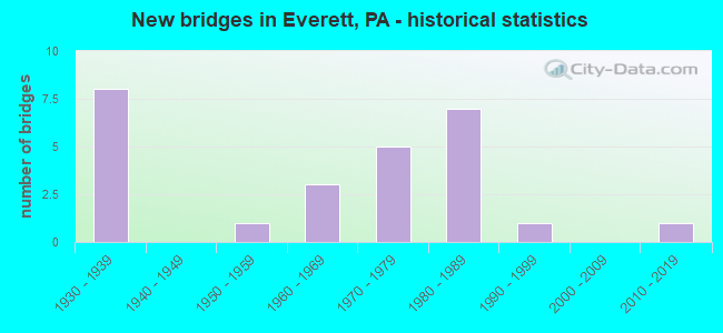
- New bridges - historical statistics
- 81930-1939
- 11950-1959
- 31960-1969
- 51970-1979
- 71980-1989
- 11990-1999
- 12010-2019

- Reconstructed bridges - Historical Statistics
- 72000-2009
- 32010-2019


- Bridge Condition - Deck
- 7.1%Excellent
- 50.0%Good
- 21.4%Satisfactory
- 21.4%Fair

- Bridge Condition - Superstructure
- 7.1%Very good
- 21.4%Good
- 35.7%Satisfactory
- 35.7%Fair

- Bridge Condition - Substructure
- 7.1%Very good
- 21.4%Good
- 42.9%Satisfactory
- 28.6%Fair

- Bridge Condition - Channel
- 23.1%Satisfactory
- 46.2%Fair
- 30.8%Poor

- Bridge Condition - Culverts
- 50.0%Good
- 50.0%Fair
Find on map >> Show street view
Structure Number: 3936, Location: EVERETT BOROUGH (Lat: 40.016611, Lng: -78.374744), Route carried "on" structure: State highway 26, Year Built: 1989, Status: Open, Structure Length: 0.61m (2.00ft), Average Daily Traffic: 2,852 (year 2020), Truck Traffic: 3%, Average Future Daily Traffic: 4,385 (year 2032), Design Load: HS 25 or greater, Features Intersected: BLOODY RUN
Minimum Vertical Clearance: 30+ m (98+ ft), Kilometerpoint: 39.120, Lanes on structure: 2, Owner: State Highway Agency, Approaching Roadway Width: 10.4m (34.1ft), Skew: 3 degrees, Material/Design: Concrete, Design/Construction: Culvert, Number Of Spans In Main Unit: 1, Length of Maximum Span: 5.5m (18.0ft), Curb or Sidewalk Widths: Left: 1.5m (4.9ft), Right: 1.5m (4.9ft), Curb-To-Curb Width: 9.1m (29.9ft), Out-to-Out Width: 13.0m (42.7ft)
Condition: Channel: Satisfactory, Culverts: Good, Operating Rating: 58.1 metric tons, Method Used To Determine Operating Rating: Load Factor (LF), Inventory Rating: 34.5 metric tons, Method Used To Determine Inventory Rating: Load Factor (LF), Structural Evaluation: Better than present minimum criteria, Deck Geometry: Meets minimum limits, Waterway Adequacy: Equal to present desirable criteria, Approach Roadway Alignment: Equal to present desirable criteria, Length Of Structure Improvement: 1.20m (3.94ft), Designated Inspection Frequency: Every 24 months, Inspection Date: Febuary 2021, Wearing Surface/Protective System: Wearing Surface: Bituminous, Membrane: Preformed Fabric, Deck Protection: Epoxy Coated Reinforcing
Find on map >> Show street view
Structure Number: 3975, Location: OVER SR 8014 (Lat: 40.010164, Lng: -78.382456), Route carried "on" structure: US 30, Year Built: 1980, Year Reconstructed: 2010, Status: Open, Structure Length: 5.15m (16.90ft), Average Daily Traffic: 7,278 (year 2020), Truck Traffic: 23%, Average Future Daily Traffic: 10,053 (year 2032), Design Load: HS 20, Features Intersected: SR 8014
Minimum Vertical Clearance: 30+ m (98+ ft), Kilometerpoint: 37.461, Lanes on structure: 2, Lanes under structure: 1, Base Highway Network: Yes, Owner: State Highway Agency, Approaching Roadway Width: 26.8m (87.9ft), Skew: 33 degrees, Material/Design: Prestressed concrete, Design/Construction: Box Beam or Girders - Single/Spread, Number Of Spans In Main Unit: 3, Length of Maximum Span: 23.5m (77.1ft), Curb or Sidewalk Widths: Left: 0.2m (0.7ft), Right: 0.2m (0.7ft), Curb-To-Curb Width: 27.1m (88.9ft), Out-to-Out Width: 29.1m (95.5ft)
Condition: Deck: Good, Superstructure: Fair, Substructure: Satisfactory, Operating Rating: 59.9 metric tons, Method Used To Determine Operating Rating: Load Factor (LF), Inventory Rating: 34.5 metric tons, Method Used To Determine Inventory Rating: Load Factor (LF), Structural Evaluation: Somewhat better than minimum adequacy, Deck Geometry: Superior to present desirable criteria, Underclear: Equal to present minimum criteria, Approach Roadway Alignment: Equal to present desirable criteria, Length Of Structure Improvement: 6.40m (21.00ft), Designated Inspection Frequency: Every 24 months, Inspection Date: July 2021, Bridge Improvement Cost: $338,000, Roadway Improvement Cost: $996,000, Total Project Cost: $4,566,000, Deck Structure Type: Concrete Cast-file-Place, Wearing Surface/Protective System: Wearing Surface: Latex Concrete, Deck Protection: Epoxy Coated Reinforcing
Find on map >> Show street view
Structure Number: 3976, Location: 1.1 MILE WEST OF TR 26 (Lat: 40.013006, Lng: -78.380114), Route carried "on" structure: US 30, Year Built: 1980, Year Reconstructed: 2008, Status: Open, Structure Length: 7.62m (25.00ft), Average Daily Traffic: 7,278 (year 2020), Truck Traffic: 23%, Average Future Daily Traffic: 10,053 (year 2032), Design Load: HS 20, Features Intersected: PRIVATE DR. (FORMER RR)
Minimum Vertical Clearance: 30+ m (98+ ft), Kilometerpoint: 37.836, Lanes on structure: 4, Lanes under structure: 2, Base Highway Network: Yes, Owner: State Highway Agency, Approaching Roadway Width: 26.8m (87.9ft), Skew: 39 degrees, Material/Design: Prestressed concrete, Design/Construction: Box Beam or Girders - Single/Spread, Number Of Spans In Main Unit: 4, Length of Maximum Span: 20.4m (66.9ft), Curb or Sidewalk Widths: Left: 0.2m (0.7ft), Right: 0.2m (0.7ft), Curb-To-Curb Width: 27.1m (88.9ft), Out-to-Out Width: 29.1m (95.5ft)
Condition: Deck: Fair, Superstructure: Fair, Substructure: Fair, Operating Rating: 72.6 metric tons, Method Used To Determine Operating Rating: Load Factor (LF), Inventory Rating: 40.8 metric tons, Method Used To Determine Inventory Rating: Load Factor (LF), Structural Evaluation: Somewhat better than minimum adequacy, Deck Geometry: Superior to present desirable criteria, Underclear: Superior to present desirable criteria, Approach Roadway Alignment: Equal to present desirable criteria, Length Of Structure Improvement: 9.40m (30.84ft), Designated Inspection Frequency: Every 24 months, Inspection Date: May 2021, Bridge Improvement Cost: $495,000, Roadway Improvement Cost: $1,459,000, Total Project Cost: $6,687,000, Deck Structure Type: Concrete Cast-file-Place, Wearing Surface/Protective System: Wearing Surface: Latex Concrete, Deck Protection: Epoxy Coated Reinforcing
Find on map >> Show street view
Structure Number: 3977, Location: OVER TR 26 (Lat: 40.027489, Lng: -78.372839), Route carried "on" structure: US 30, Year Built: 1980, Year Reconstructed: 2000, Status: Open, Structure Length: 8.99m (29.49ft), Average Daily Traffic: 7,278 (year 2020), Truck Traffic: 23%, Average Future Daily Traffic: 10,053 (year 2032), Design Load: HS 20, Features Intersected: BLOODY RUN & PA 26
Minimum Vertical Clearance: 30+ m (98+ ft), Kilometerpoint: 39.680, Lanes on structure: 4, Lanes under structure: 2, Base Highway Network: Yes, Owner: State Highway Agency, Approaching Roadway Width: 26.8m (87.9ft), Skew: 31 degrees, Material/Design: Prestressed concrete, Design/Construction: Box Beam or Girders - Single/Spread, Number Of Spans In Main Unit: 5, Length of Maximum Span: 20.1m (65.9ft), Curb or Sidewalk Widths: Left: 0.2m (0.7ft), Right: 0.2m (0.7ft), Curb-To-Curb Width: 27.3m (89.6ft), Out-to-Out Width: 29.1m (95.5ft)
Condition: Deck: Good, Superstructure: Satisfactory, Substructure: Fair, Channel: Satisfactory, Operating Rating: 67.1 metric tons, Method Used To Determine Operating Rating: Load Factor (LF), Inventory Rating: 38.1 metric tons, Method Used To Determine Inventory Rating: Load Factor (LF), Structural Evaluation: Somewhat better than minimum adequacy, Deck Geometry: Superior to present desirable criteria, Underclear: Superior to present desirable criteria, Waterway Adequacy: Superior to present desirable criteria, Approach Roadway Alignment: Equal to present desirable criteria, Length Of Structure Improvement: 11.20m (36.75ft), Designated Inspection Frequency: Every 24 months, Inspection Date: May 2021, Bridge Improvement Cost: $592,000, Roadway Improvement Cost: $1,742,000, Total Project Cost: $7,987,000, Deck Structure Type: Concrete Cast-file-Place, Wearing Surface/Protective System: Wearing Surface: Latex Concrete, Deck Protection: Epoxy Coated Reinforcing
Find on map >> Show street view
Structure Number: 3978, Location: 0.5 MILE EAST OF SR 1007 (Lat: 40.022981, Lng: -78.358550), Route carried "on" structure: US 30, Year Built: 1979, Year Reconstructed: 2017, Status: Open, Structure Length: 3.54m (11.61ft), Average Daily Traffic: 7,958 (year 2021), Truck Traffic: 22%, Average Future Daily Traffic: 12,567 (year 2032), Design Load: HS 20, Features Intersected: T466 STEIN ROAD
Minimum Vertical Clearance: 30+ m (98+ ft), Kilometerpoint: 40.557, Lanes on structure: 4, Lanes under structure: 2, Base Highway Network: Yes, Owner: State Highway Agency, Approaching Roadway Width: 26.8m (87.9ft), Skew: 31 degrees, Material/Design: Prestressed concrete, Design/Construction: Box Beam or Girders - Single/Spread, Number Of Spans In Main Unit: 3, Length of Maximum Span: 15.8m (51.8ft), Curb or Sidewalk Widths: Left: 0.2m (0.7ft), Right: 0.2m (0.7ft), Curb-To-Curb Width: 27.3m (89.6ft), Out-to-Out Width: 29.1m (95.5ft)
Condition: Deck: Good, Superstructure: Good, Substructure: Satisfactory, Operating Rating: 57.2 metric tons, Method Used To Determine Operating Rating: Load Factor (LF), Inventory Rating: 34.5 metric tons, Method Used To Determine Inventory Rating: Load Factor (LF), Structural Evaluation: Equal to present minimum criteria, Deck Geometry: Superior to present desirable criteria, Underclear: Equal to present minimum criteria, Approach Roadway Alignment: Equal to present desirable criteria, Length Of Structure Improvement: 4.40m (14.44ft), Designated Inspection Frequency: Every 24 months, Inspection Date: April 2021, Bridge Improvement Cost: $233,000, Roadway Improvement Cost: $685,000, Total Project Cost: $3,141,000, Deck Structure Type: Concrete Cast-file-Place, Wearing Surface/Protective System: Wearing Surface: Latex Concrete, Deck Protection: Epoxy Coated Reinforcing
Find on map >> Show street view
Structure Number: 4158, Location: VALLEYMILL (Lat: 40.032281, Lng: -78.401728), Route carried "on" structure: State highway , Year Built: 1951, Status: Open, Structure Length: 2.04m (6.69ft), Average Daily Traffic: 291 (year 2022), Truck Traffic: 12%, Average Future Daily Traffic: 526 (year 2032), Design Load: H 20, Features Intersected: SNAKESPRING VALLEY RUN, Facility Carried by Structure: SR 1005
Minimum Vertical Clearance: 30+ m (98+ ft), Kilometerpoint: 1.389, Lanes on structure: 2, Owner: State Highway Agency, Approaching Roadway Width: 5.2m (17.1ft), Skew: 4 degrees, Material/Design: Steel, Design/Construction: Stringer/Multi-beam, Number Of Spans In Main Unit: 1, Length of Maximum Span: 20.1m (65.9ft), Curb or Sidewalk Widths: Left: 0.2m (0.7ft), Right: 0.2m (0.7ft), Curb-To-Curb Width: 7.3m (24.0ft), Out-to-Out Width: 7.9m (25.9ft)
Condition: Deck: Fair, Superstructure: Fair, Substructure: Satisfactory, Channel: Fair, Operating Rating: 59.0 metric tons, Method Used To Determine Operating Rating: Load Factor (LF), Inventory Rating: 35.4 metric tons, Method Used To Determine Inventory Rating: Load Factor (LF), Structural Evaluation: Somewhat better than minimum adequacy, Deck Geometry: Somewhat better than minimum adequacy, Waterway Adequacy: Equal to present desirable criteria, Approach Roadway Alignment: Equal to present desirable criteria, Length Of Structure Improvement: 2.70m (8.86ft), Designated Inspection Frequency: Every 24 months, Inspection Date: March 2021, Deck Structure Type: Closed Grating, Wearing Surface/Protective System: Wearing Surface: Bituminous
Find on map >> Show street view
Structure Number: 4164, Location: 3 MI.E. OF EVERETT (Lat: 40.005772, Lng: -78.325644), Route carried "on" structure: State highway , Year Built: 1965, Status: Open, Structure Length: 1.28m (4.20ft), Average Daily Traffic: 87 (year 2021), Truck Traffic: 9%, Average Future Daily Traffic: 84 (year 2032), Design Load: H 20, Features Intersected: GREY'S RUN, Facility Carried by Structure: SR 1006
Minimum Vertical Clearance: 30+ m (98+ ft), Kilometerpoint: 3.203, Lanes on structure: 2, Owner: State Highway Agency, Approaching Roadway Width: 5.8m (19.0ft), Skew: 1 degrees, Material/Design: Concrete, Design/Construction: Culvert, Number Of Spans In Main Unit: 2, Length of Maximum Span: 5.5m (18.0ft)
Condition: Channel: Fair, Culverts: Good, Operating Rating: 56.2 metric tons, Method Used To Determine Operating Rating: Load Factor (LF), Inventory Rating: 33.6 metric tons, Method Used To Determine Inventory Rating: Load Factor (LF), Structural Evaluation: Better than present minimum criteria, Waterway Adequacy: Better than present minimum criteria, Approach Roadway Alignment: Equal to present desirable criteria, Length Of Structure Improvement: 1.60m (5.25ft), Designated Inspection Frequency: Every 24 months, Inspection Date: Febuary 2021, Bridge Improvement Cost: $52,000, Roadway Improvement Cost: $264,000, Total Project Cost: $700,000
Find on map >> Show street view
Structure Number: 4166, Location: NEAR EVERETT BORO. (Lat: 40.026344, Lng: -78.367842), Route carried "on" structure: State highway , Year Built: 1979, Year Reconstructed: 2009, Status: Open, Structure Length: 6.28m (20.60ft), Average Daily Traffic: 3,948 (year 2021), Truck Traffic: 15%, Average Future Daily Traffic: 4,980 (year 2032), Design Load: HS 20, Features Intersected: US 30, Facility Carried by Structure: SR 1007
Minimum Vertical Clearance: 30+ m (98+ ft), Kilometerpoint: 0.000, Lanes on structure: 2, Lanes under structure: 6, Base Highway Network: Yes, Owner: State Highway Agency, Approaching Roadway Width: 8.8m (28.9ft), Skew: 31 degrees, Material/Design: Prestressed concrete, Design/Construction: Box Beam or Girders - Single/Spread, Number Of Spans In Main Unit: 4, Length of Maximum Span: 20.1m (65.9ft), Curb or Sidewalk Widths: Left: 0.2m (0.7ft), Right: 0.2m (0.7ft), Curb-To-Curb Width: 9.4m (30.8ft), Out-to-Out Width: 20.6m (67.6ft)
Condition: Deck: Good, Superstructure: Fair, Substructure: Satisfactory, Operating Rating: 52.6 metric tons, Method Used To Determine Operating Rating: Load Factor (LF), Inventory Rating: 30.8 metric tons, Method Used To Determine Inventory Rating: Load Factor (LF), Structural Evaluation: Somewhat better than minimum adequacy, Deck Geometry: Meets minimum limits, Underclear: Equal to present minimum criteria, Approach Roadway Alignment: Equal to present desirable criteria, Length Of Structure Improvement: 7.80m (25.59ft), Designated Inspection Frequency: Every 24 months, Inspection Date: April 2021, Bridge Improvement Cost: $290,000, Roadway Improvement Cost: $854,000, Total Project Cost: $3,916,000, Deck Structure Type: Concrete Cast-file-Place, Wearing Surface/Protective System: Wearing Surface: Latex Concrete, Deck Protection: Epoxy Coated Reinforcing
Find on map >> Show street view
Structure Number: 4168, Location: 2.5 MI.SE.OF TATESVILLE (Lat: 40.026269, Lng: -78.319619), Route carried "on" structure: State highway , Year Built: 1992, Status: Open, Structure Length: 9.39m (30.81ft), Average Daily Traffic: 310 (year 2022), Truck Traffic: 5%, Average Future Daily Traffic: 416 (year 2032), Design Load: HS 25 or greater, Features Intersected: RAYSTOWN BR.JUNIATA RIV., Facility Carried by Structure: SR 1008
Minimum Vertical Clearance: 30+ m (98+ ft), Kilometerpoint: 1.310, Lanes on structure: 2, Owner: State Highway Agency, Approaching Roadway Width: 7.6m (24.9ft), Skew: 2 degrees, Material/Design: Prestressed concrete, Design/Construction: Box Beam or Girders - Single/Spread, Number Of Spans In Main Unit: 4, Length of Maximum Span: 22.9m (75.1ft), Curb or Sidewalk Widths: Left: 0.2m (0.7ft), Right: 0.2m (0.7ft), Curb-To-Curb Width: 8.5m (27.9ft), Out-to-Out Width: 9.6m (31.5ft)
Condition: Deck: Good, Superstructure: Satisfactory, Substructure: Good, Channel: Fair, Operating Rating: 83.5 metric tons, Method Used To Determine Operating Rating: Load Factor (LF), Inventory Rating: 40.8 metric tons, Method Used To Determine Inventory Rating: Load Factor (LF), Structural Evaluation: Equal to present minimum criteria, Deck Geometry: Equal to present minimum criteria, Waterway Adequacy: Superior to present desirable criteria, Approach Roadway Alignment: Better than present minimum criteria, Length Of Structure Improvement: 10.40m (34.12ft), Designated Inspection Frequency: Every 48 months, Inspection Date: June 2019, Deck Structure Type: Concrete Cast-file-Place, Wearing Surface/Protective System: Wearing Surface: Monolithic Concrete, Deck Protection: Epoxy Coated Reinforcing
Find on map >> Show street view
Structure Number: 4172, Location: 3 MI.E.OF EVERETT (Lat: 40.015081, Lng: -78.304358), Route carried "on" structure: State highway , Year Built: 1937, Year Reconstructed: 2010, Status: Open, Structure Length: 7.86m (25.79ft), Average Daily Traffic: 141 (year 2022), Truck Traffic: 6%, Average Future Daily Traffic: 195 (year 2032), Design Load: HS 20, Features Intersected: RAYSTOWN BR JUNIATA RIV, Facility Carried by Structure: SR 1010
Minimum Vertical Clearance: 4.24m (13.91ft), Kilometerpoint: 1.812, Lanes on structure: 2, Owner: State Highway Agency, Approaching Roadway Width: 6.7m (22.0ft), Material/Design: Steel, Design/Construction: Truss - Thru, Number Of Spans In Main Unit: 2, Length of Maximum Span: 38.1m (125.0ft), Curb or Sidewalk Widths: Left: 0.2m (0.7ft), Right: 0.2m (0.7ft), Curb-To-Curb Width: 5.8m (19.0ft), Out-to-Out Width: 6.4m (21.0ft)
Condition: Deck: Good, Superstructure: Satisfactory, Substructure: Good, Channel: Fair, Operating Rating: 61.7 metric tons, Method Used To Determine Operating Rating: Load Factor (LF), Inventory Rating: 37.2 metric tons, Method Used To Determine Inventory Rating: Load Factor (LF), Structural Evaluation: Equal to present minimum criteria, Deck Geometry: High priority of corrective action, Waterway Adequacy: Equal to present desirable criteria, Approach Roadway Alignment: Meets minimum limits, Length Of Structure Improvement: 10.00m (32.81ft), Designated Inspection Frequency: Every 24 months, Critical Feature Inspection Frequency: Every 24 months, Inspection Date: April 2020, Critical Feature Inspection Date: April 2020, Bridge Improvement Cost: $242,000, Roadway Improvement Cost: $714,000, Total Project Cost: $3,272,000, Deck Structure Type: Concrete Cast-file-Place, Wearing Surface/Protective System: Wearing Surface: Monolithic Concrete, Deck Protection: Epoxy Coated Reinforcing
Find on map >> Show street view
Structure Number: 4176, Location: 1.5 MI.E.OF TATESVILLE (Lat: 40.054003, Lng: -78.327939), Route carried "on" structure: State highway , Year Built: 1937, Year Reconstructed: 2008, Status: Open, Structure Length: 1.34m (4.40ft), Average Daily Traffic: 354 (year 2021), Truck Traffic: 3%, Average Future Daily Traffic: 547 (year 2032), Design Load: H 15, Features Intersected: JOHNS BR RAYSTWN BR JUN, Facility Carried by Structure: SR 1012
Minimum Vertical Clearance: 30+ m (98+ ft), Kilometerpoint: 1.695, Lanes on structure: 2, Owner: State Highway Agency, Approaching Roadway Width: 6.7m (22.0ft), Skew: 4 degrees, Material/Design: Steel, Design/Construction: Stringer/Multi-beam, Number Of Spans In Main Unit: 1, Length of Maximum Span: 11.9m (39.0ft), Curb or Sidewalk Widths: Left: 0.1m (0.3ft), Right: 0.1m (0.3ft), Curb-To-Curb Width: 7.3m (24.0ft), Out-to-Out Width: 7.9m (25.9ft)
Condition: Deck: Satisfactory, Superstructure: Satisfactory, Substructure: Satisfactory, Channel: Poor, Operating Rating: 44.5 metric tons, Method Used To Determine Operating Rating: Load Factor (LF), Inventory Rating: 26.3 metric tons, Method Used To Determine Inventory Rating: Load Factor (LF), Structural Evaluation: Equal to present minimum criteria, Deck Geometry: Somewhat better than minimum adequacy, Waterway Adequacy: Better than present minimum criteria, Approach Roadway Alignment: Somewhat better than minimum adequacy, Length Of Structure Improvement: 1.60m (5.25ft), Designated Inspection Frequency: Every 24 months, Inspection Date: March 2021, Bridge Improvement Cost: $53,000, Roadway Improvement Cost: $264,000, Total Project Cost: $714,000, Deck Structure Type: Closed Grating, Wearing Surface/Protective System: Wearing Surface: Integral Concrete
Find on map >> Show street view
Structure Number: 4215, Location: Everett (Lat: 40.007431, Lng: -78.380089), Route carried "on" structure: State highway , Year Built: 1937, Year Reconstructed: 2014, Status: Open, Structure Length: 6.49m (21.29ft), Average Daily Traffic: 3,658 (year 2020), Truck Traffic: 5%, Average Future Daily Traffic: 5,698 (year 2032), Design Load: H 20, Features Intersected: RAYSTOWN BR.JUNIATA RIV., Facility Carried by Structure: SR 1029
Minimum Vertical Clearance: 30+ m (98+ ft), Kilometerpoint: 0.000, Lanes on structure: 2, Owner: State Highway Agency, Approaching Roadway Width: 10.4m (34.1ft), Material/Design: Steel, Design/Construction: Truss - Thru, Number Of Spans In Main Unit: 2, Length of Maximum Span: 31.4m (103.0ft), Curb or Sidewalk Widths: Left: 1.4m (4.6ft), Right: 0.0m, Curb-To-Curb Width: 6.9m (22.6ft), Out-to-Out Width: 7.3m (24.0ft)
Condition: Deck: Good, Superstructure: Fair, Substructure: Satisfactory, Channel: Poor, Operating Rating: 41.7 metric tons, Method Used To Determine Operating Rating: Load Factor (LF), Inventory Rating: 24.5 metric tons, Method Used To Determine Inventory Rating: Load Factor (LF), Structural Evaluation: Somewhat better than minimum adequacy, Deck Geometry: High priority of replacement, Waterway Adequacy: Equal to present desirable criteria, Approach Roadway Alignment: Better than present minimum criteria, Length Of Structure Improvement: 7.20m (23.62ft), Designated Inspection Frequency: Every 24 months, Critical Feature Inspection Frequency: Every 24 months, Inspection Date: June 2021, Critical Feature Inspection Date: June 2021, Bridge Improvement Cost: $13,000, Roadway Improvement Cost: $37,000, Total Project Cost: $171,000, Deck Structure Type: Concrete Cast-file-Place, Wearing Surface/Protective System: Wearing Surface: Latex Concrete, Deck Protection: Epoxy Coated Reinforcing
Find on map >> Show street view
Structure Number: 427, Location: 1 MILE EAST OF MENCH (Lat: 39.970700, Lng: -78.308017), Route carried "on" structure: State highway , Year Built: 1961, Year Reconstructed: 2012, Status: Open, Structure Length: 3.81m (12.50ft), Average Daily Traffic: 321 (year 2021), Truck Traffic: 3%, Average Future Daily Traffic: 328 (year 2032), Design Load: HS 20, Features Intersected: SHAFFERS RUN, Facility Carried by Structure: SR 2022
Minimum Vertical Clearance: 30+ m (98+ ft), Kilometerpoint: 1.772, Lanes on structure: 2, Owner: State Highway Agency, Approaching Roadway Width: 6.1m (20.0ft), Skew: 3 degrees, Material/Design: Prestressed concrete, Design/Construction: Box Beam or Girders - Single/Spread, Number Of Spans In Main Unit: 2, Length of Maximum Span: 18.6m (61.0ft), Curb-To-Curb Width: 8.5m (27.9ft), Out-to-Out Width: 10.2m (33.5ft)
Condition: Deck: Satisfactory, Superstructure: Good, Substructure: Fair, Channel: Fair, Operating Rating: 77.1 metric tons, Method Used To Determine Operating Rating: Load Factor (LF), Inventory Rating: 28.1 metric tons, Method Used To Determine Inventory Rating: Load Factor (LF), Structural Evaluation: Somewhat better than minimum adequacy, Deck Geometry: Equal to present minimum criteria, Waterway Adequacy: Equal to present desirable criteria, Approach Roadway Alignment: Equal to present desirable criteria, Length Of Structure Improvement: 4.70m (15.42ft), Designated Inspection Frequency: Every 24 months, Inspection Date: April 2021, Bridge Improvement Cost: $115,000, Roadway Improvement Cost: $338,000, Total Project Cost: $1,549,000, Deck Structure Type: Concrete Cast-file-Place, Wearing Surface/Protective System: Wearing Surface: Latex Concrete
Find on map >> Show street view
Structure Number: 4278, Location: 1.5 MI.W.JUNIATA CROSSING (Lat: 39.994181, Lng: -78.315250), Route carried "on" structure: State highway , Year Built: 1961, Year Reconstructed: 2012, Status: Open, Structure Length: 5.15m (16.90ft), Average Daily Traffic: 155 (year 2021), Truck Traffic: 2%, Average Future Daily Traffic: 150 (year 2032), Design Load: HS 20, Features Intersected: BRUSH CREEK, Facility Carried by Structure: SR 2026
Minimum Vertical Clearance: 30+ m (98+ ft), Kilometerpoint: 0.916, Lanes on structure: 2, Owner: State Highway Agency, Approaching Roadway Width: 5.8m (19.0ft), Skew: 2 degrees, Material/Design: Prestressed concrete, Design/Construction: Box Beam or Girders - Single/Spread, Number Of Spans In Main Unit: 3, Length of Maximum Span: 16.8m (55.1ft), Curb-To-Curb Width: 8.5m (27.9ft), Out-to-Out Width: 10.2m (33.5ft)
Condition: Deck: Fair, Superstructure: Good, Substructure: Good, Channel: Poor, Operating Rating: 64.4 metric tons, Method Used To Determine Operating Rating: Load Factor (LF), Inventory Rating: 29.0 metric tons, Method Used To Determine Inventory Rating: Load Factor (LF), Structural Evaluation: Better than present minimum criteria, Deck Geometry: Equal to present minimum criteria, Waterway Adequacy: Superior to present desirable criteria, Approach Roadway Alignment: Equal to present desirable criteria, Length Of Structure Improvement: 16.70m (54.79ft), Designated Inspection Frequency: Every 24 months, Inspection Date: March 2021, Bridge Improvement Cost: $419,000, Roadway Improvement Cost: $1,326,000, Total Project Cost: $5,652,000, Deck Structure Type: Concrete Cast-file-Place, Wearing Surface/Protective System: Wearing Surface: Latex Concrete
Find on map >> Show street view
Structure Number: 4446, Location: EAST OF EARLSTON (Lat: 39.991667, Lng: -78.336667), Route carried "on" structure: Interstate 70, Year Built: 1939, Status: Open, Structure Length: 0.70m (2.30ft), Average Daily Traffic: 33,684 (year 2001), Truck Traffic: 39%, Average Future Daily Traffic: 38,535 (year 2030), Design Load: HS 20, Features Intersected: GREY'S RUN, Facility Carried by Structure: PA TPK (I-76)
Minimum Vertical Clearance: 30+ m (98+ ft), Kilometerpoint: 0.000, Lanes on structure: 4, Base Highway Network: Yes, Toll: On toll road, Owner: State Toll Authority, Approaching Roadway Width: 23.2m (76.1ft), Skew: 30 degrees, Material/Design: Concrete, Design/Construction: Culvert, Number Of Spans In Main Unit: 1, Length of Maximum Span: 7.0m (23.0ft)
Condition: Channel: Poor, Culverts: Fair, Operating Rating: 89.8 metric tons, Method Used To Determine Operating Rating: Field evaluation and documented engineering judgment, Inventory Rating: 32.7 metric tons, Method Used To Determine Inventory Rating: Field evaluation and documented engineering judgment, Structural Evaluation: Somewhat better than minimum adequacy, Waterway Adequacy: Superior to present desirable criteria, Approach Roadway Alignment: Equal to present desirable criteria, Length Of Structure Improvement: 1.40m (4.59ft), Designated Inspection Frequency: Every 24 months, Inspection Date: October 2020, Bridge Improvement Cost: $23,000, Roadway Improvement Cost: $68,000, Total Project Cost: $312,000
Find on map >> Show street view
Structure Number: 4447, Location: E.OF EARLSTON (Lat: 39.992725, Lng: -78.323756), Route carried "on" structure: State highway , Year Built: 1939, Status: Open, Structure Length: 2.65m (8.69ft), Average Daily Traffic: 189 (year 2020), Truck Traffic: 5%, Average Future Daily Traffic: 245 (year 2030), Design Load: HS 20, Features Intersected: PA TPK (I-76), Facility Carried by Structure: SR 1006 (LR 05113)
Minimum Vertical Clearance: 30+ m (98+ ft), Kilometerpoint: 5.425, Lanes on structure: 2, Lanes under structure: 4, Owner: State Toll Authority, Approaching Roadway Width: 8.5m (27.9ft), Material/Design: Concrete, Design/Construction: Frame, Number Of Spans In Main Unit: 1, Length of Maximum Span: 23.8m (78.1ft), Curb or Sidewalk Widths: Left: 0.2m (0.7ft), Right: 0.2m (0.7ft), Curb-To-Curb Width: 6.1m (20.0ft), Out-to-Out Width: 7.0m (23.0ft)
Condition: Deck: Satisfactory, Superstructure: Satisfactory, Substructure: Fair, Operating Rating: 47.2 metric tons, Method Used To Determine Operating Rating: Load Factor (LF), Inventory Rating: 28.1 metric tons, Method Used To Determine Inventory Rating: Load Factor (LF), Structural Evaluation: Somewhat better than minimum adequacy, Deck Geometry: Meets minimum limits, Underclear: High priority of corrective action, Approach Roadway Alignment: Equal to present desirable criteria, Length Of Structure Improvement: 3.40m (11.15ft), Designated Inspection Frequency: Every 24 months, Inspection Date: September 2020, Bridge Improvement Cost: $6,000, Roadway Improvement Cost: $16,000, Total Project Cost: $75,000, Wearing Surface/Protective System: Wearing Surface: Bituminous
Find on map >> Show street view
Structure Number: 4448, Location: NORTH OF MENCH (Lat: 39.987969, Lng: -78.306047), Route carried "on" structure: Interstate 76, Year Built: 1939, Status: Open, Structure Length: 3.17m (10.40ft), Average Daily Traffic: 33,684 (year 2001), Truck Traffic: 36%, Average Future Daily Traffic: 38,535 (year 2030), Design Load: HS 20, Features Intersected: BRUSH CREEK
Minimum Vertical Clearance: 30+ m (98+ ft), Kilometerpoint: 0.000, Lanes on structure: 4, Base Highway Network: Yes, Toll: On toll road, Owner: State Toll Authority, Approaching Roadway Width: 23.2m (76.1ft), Skew: 30 degrees, Material/Design: Concrete, Design/Construction: Culvert, Number Of Spans In Main Unit: 2, Length of Maximum Span: 15.8m (51.8ft)
Condition: Channel: Fair, Culverts: Fair, Operating Rating: 89.8 metric tons, Method Used To Determine Operating Rating: Load Factor (LF), Inventory Rating: 89.8 metric tons, Method Used To Determine Inventory Rating: Load Factor (LF), Structural Evaluation: Somewhat better than minimum adequacy, Waterway Adequacy: Superior to present desirable criteria, Approach Roadway Alignment: Equal to present desirable criteria, Length Of Structure Improvement: 4.00m (13.12ft), Designated Inspection Frequency: Every 24 months, Inspection Date: October 2020
Find on map >> Show street view
Structure Number: 54085, Location: 2 MI EAST OF SR 26 (Lat: 40.052650, Lng: -78.324831), Route carried "on" structure: State highway , Year Built: 2018, Status: Open, Structure Length: 7.56m (24.80ft), Average Daily Traffic: 354 (year 2021), Truck Traffic: 3%, Average Future Daily Traffic: 547 (year 2032), Design Load: HL 93, Features Intersected: RAYSTOWN BR JUNIATA RIV, Facility Carried by Structure: Ritchey Bridge Rd
Minimum Vertical Clearance: 30+ m (98+ ft), Kilometerpoint: 2.789, Lanes on structure: 2, Owner: State Highway Agency, Maintenance Responsibility: Private, Approaching Roadway Width: 7.3m (24.0ft), Material/Design: Prestressed concrete continuous, Design/Construction: Stringer/Multi-beam, Number Of Spans In Main Unit: 2, Length of Maximum Span: 37.5m (123.0ft), Curb-To-Curb Width: 7.5m (24.6ft), Out-to-Out Width: 8.1m (26.6ft)
Condition: Deck: Excellent, Superstructure: Very good, Substructure: Very good, Channel: Satisfactory, Operating Rating: 51.5 metric tons, Method Used To Determine Operating Rating: Assigned ratings based on Load and Resistance Factor Design (LRFD) reported by rating factor (RF) using HL93 loadings, Inventory Rating: 39.9 metric tons, Method Used To Determine Inventory Rating: Assigned ratings based on Load and Resistance Factor Design (LRFD) reported by rating factor (RF) using HL93 loadings, Structural Evaluation: Equal to present desirable criteria, Deck Geometry: Somewhat better than minimum adequacy, Waterway Adequacy: Superior to present desirable criteria, Approach Roadway Alignment: Better than present minimum criteria, Designated Inspection Frequency: Every 24 months, Inspection Date: July 2020, Deck Structure Type: Concrete Cast-file-Place, Wearing Surface/Protective System: Wearing Surface: Integral Concrete, Deck Protection: Epoxy Coated Reinforcing
Find on map >> Show street view
Structure Number: 3975, Location: OVER SR 8014 (Lat: 40.010164, Lng: -78.382456), Route carried "under" structure: State highway , Year Built: 1980, Structure Length: 0. m, Average Daily Traffic: 3,432 (year 2022), Truck Traffic: 12%, Features Intersected: SR 8014, Facility Carried by Structure: US 30
Minimum Vertical Clearance: 4.52m (14.83ft), Kilometerpoint: 0.000, Lanes on structure: 2, Lanes under structure: 1, Material/Design: Prestressed concrete, Design/Construction: Box Beam or Girders - Single/Spread, Length of Maximum Span: 23.5m (77.1ft)
Find on map >> Show street view
Structure Number: 3976, Location: 1.1 MILE WEST OF TR 26 (Lat: 40.013006, Lng: -78.380114), Route carried "under" structure: Other road , Year Built: 1980, Structure Length: 0. m, Average Daily Traffic: 10 (year 1990), Features Intersected: PRIVATE DR. (FORMER RR), Facility Carried by Structure: US 30
Minimum Vertical Clearance: 6.75m (22.15ft), Kilometerpoint: 0.000, Lanes on structure: 4, Lanes under structure: 2, Material/Design: Prestressed concrete, Design/Construction: Box Beam or Girders - Single/Spread, Length of Maximum Span: 20.4m (66.9ft)
Find on map >> Show street view
Structure Number: 3977, Location: OVER TR 26 (Lat: 40.027489, Lng: -78.372839), Route carried "under" structure: State highway 26, Year Built: 1980, Structure Length: 0. m, Average Daily Traffic: 2,852 (year 2020), Truck Traffic: 3%, Features Intersected: BLOODY RUN & PA 26, Facility Carried by Structure: US 30
Minimum Vertical Clearance: 8.84m (29.00ft), Kilometerpoint: 39.693, Lanes on structure: 4, Lanes under structure: 2, Material/Design: Prestressed concrete, Design/Construction: Box Beam or Girders - Single/Spread, Length of Maximum Span: 20.1m (65.9ft)
Find on map >> Show street view
Structure Number: 3978, Location: 0.5 MILE EAST OF SR 1007 (Lat: 40.022981, Lng: -78.358550), Route carried "under" structure: City street , Year Built: 1979, Structure Length: 0. m, Average Daily Traffic: 25 (year 1993), Features Intersected: T466 STEIN ROAD, Facility Carried by Structure: US 30
Minimum Vertical Clearance: 4.44m (14.57ft), Kilometerpoint: 0.000, Lanes on structure: 4, Lanes under structure: 2, Material/Design: Prestressed concrete, Design/Construction: Box Beam or Girders - Single/Spread, Length of Maximum Span: 15.8m (51.8ft)
Find on map >> Show street view
Structure Number: 4166, Location: NEAR EVERETT BORO. (Lat: 40.026344, Lng: -78.367842), Route carried "under" structure: US 30, Year Built: 1979, Structure Length: 0. m, Average Daily Traffic: 3,747 (year 2020), Truck Traffic: 24%, Features Intersected: US 30, Facility Carried by Structure: SR 1007
Minimum Vertical Clearance: 4.60m (15.09ft), Kilometerpoint: 39.674, Lanes on structure: 2, Lanes under structure: 3, Material/Design: Prestressed concrete, Design/Construction: Box Beam or Girders - Single/Spread, Length of Maximum Span: 20.1m (65.9ft)
Find on map >> Show street view
Structure Number: 4166, Location: NEAR EVERETT BORO. (Lat: 40.026344, Lng: -78.367842), Route carried "under" structure: US 30, Year Built: 1979, Structure Length: 0. m, Average Daily Traffic: 3,531 (year 2020), Truck Traffic: 22%, Features Intersected: US 30, Facility Carried by Structure: SR 1007
Minimum Vertical Clearance: 4.47m (14.67ft), Kilometerpoint: 39.680, Lanes on structure: 2, Lanes under structure: 3, Material/Design: Prestressed concrete, Design/Construction: Box Beam or Girders - Single/Spread, Length of Maximum Span: 20.1m (65.9ft)
Find on map >> Show street view
Structure Number: 4444, Location: NEAR EARLSTON (Lat: 40.016667, Lng: -78.356667), Route carried "under" structure: State highway 26, Year Built: 1939, Structure Length: 0. m, Average Daily Traffic: 3,463 (year 2020), Truck Traffic: 4%, Features Intersected: PA 26 (LR 286), Facility Carried by Structure: PA TPK (I-76)
Minimum Vertical Clearance: 7.46m (24.48ft), Kilometerpoint: 36.362, Lanes on structure: 4, Lanes under structure: 2, Material/Design: Concrete, Design/Construction: Culvert, Length of Maximum Span: 11.0m (36.1ft)
Find on map >> Show street view
Structure Number: 4447, Location: E.OF EARLSTON (Lat: 39.992725, Lng: -78.323756), Route carried "under" structure: Interstate 76, Year Built: 1939, Structure Length: 0. m, Average Daily Traffic: 33,684 (year 2001), Truck Traffic: 36%, Features Intersected: PA TPK (I-76), Facility Carried by Structure: SR 1006 (LR 05113)
Minimum Vertical Clearance: 7.46m (24.48ft), Kilometerpoint: 253.456, Lanes on structure: 2, Lanes under structure: 4, Toll: On toll road, Material/Design: Concrete, Design/Construction: Frame, Length of Maximum Span: 23.8m (78.1ft)