Bridge Statistics for Everly, Iowa (IA)
Condition, Traffic, Stress, Structural Evaluation, Project Costs
- National Bridge Inventory (NBI) Statistics
- 23Number of bridges
- 220ft / 67.3mTotal length
- 13,500Total average daily traffic
- 2,685Total average daily truck traffic
- 13,850Total future (year 2038) average daily traffic
- National Bridge Inventory (NBI) Registered Bridges for Everly
- No street view available for this location
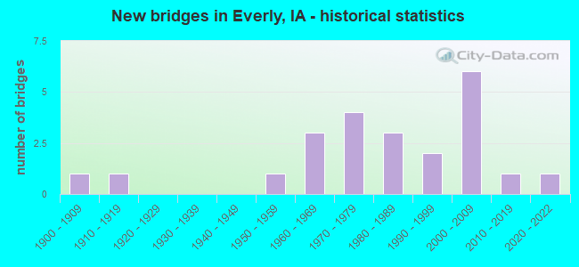
- New bridges - historical statistics
- 11900-1909
- 11910-1919
- 11950-1959
- 31960-1969
- 41970-1979
- 31980-1989
- 21990-1999
- 62000-2009
- 12010-2019
- 12020-2022

- Reconstructed bridges - Historical Statistics
- 11950-1959
- 01960-1969
- 01970-1979
- 11980-1989


- Bridge Condition - Deck
- 5.6%Very good
- 61.1%Good
- 11.1%Satisfactory
- 11.1%Fair
- 11.1%Poor

- Bridge Condition - Superstructure
- 5.6%Very good
- 61.1%Good
- 16.7%Satisfactory
- 5.6%Fair
- 11.1%Poor

- Bridge Condition - Substructure
- 16.7%Very good
- 44.4%Good
- 22.2%Satisfactory
- 16.7%Fair

- Bridge Condition - Channel
- 4.3%Very good
- 30.4%Good
- 52.2%Satisfactory
- 13.0%Fair

- Bridge Condition - Culverts
- 40.0%Good
- 20.0%Satisfactory
- 40.0%Fair
Find on map >> Show street view
Structure Number: 20291, Location: 2.4 mi. W of S.R. M27 (Lat: 43.184050, Lng: -95.376744), Route carried "on" structure: US 18, Year Built: 1987, Status: Open, Structure Length: 2.53m (8.30ft), Average Daily Traffic: 2,700 (year 2020), Truck Traffic: 26%, Average Future Daily Traffic: 2,700 (year 2041), Design Load: HS 20, Features Intersected: OCHEYDON RIVER OVERFLOW
Minimum Vertical Clearance: 30+ m (98+ ft), Kilometerpoint: 106.701, Lanes on structure: 2, Base Highway Network: Yes, Owner: State Highway Agency, Approaching Roadway Width: 12.2m (40.0ft), Material/Design: Concrete continuous, Design/Construction: Slab, Number Of Spans In Main Unit: 3, Length of Maximum Span: 9.4m (30.8ft), Curb-To-Curb Width: 12.2m (40.0ft), Out-to-Out Width: 13.2m (43.3ft)
Condition: Deck: Good, Superstructure: Good, Substructure: Very good, Channel: Good, Operating Rating: 90.5 metric tons, Method Used To Determine Operating Rating: Load Factor (LF), Inventory Rating: 54.3 metric tons, Method Used To Determine Inventory Rating: Load Factor (LF), Structural Evaluation: Better than present minimum criteria, Deck Geometry: Equal to present minimum criteria, Waterway Adequacy: Equal to present desirable criteria, Approach Roadway Alignment: Equal to present desirable criteria, Designated Inspection Frequency: Every 24 months, Inspection Date: August 2021, Deck Structure Type: Concrete Cast-file-Place, Wearing Surface/Protective System: Wearing Surface: Epoxy Overlay, Deck Protection: Epoxy Coated Reinforcing
Find on map >> Show street view
Structure Number: 20301, Location: 2.3 mi W of SR M-27 (Lat: 43.184017, Lng: -95.374986), Route carried "on" structure: US 18, Year Built: 2014, Status: Open, Structure Length: 4.60m (15.09ft), Average Daily Traffic: 2,700 (year 2020), Truck Traffic: 26%, Average Future Daily Traffic: 2,700 (year 2040), Design Load: HL 93, Features Intersected: OCHEYEDAN RIVER
Minimum Vertical Clearance: 30+ m (98+ ft), Kilometerpoint: 106.844, Lanes on structure: 2, Base Highway Network: Yes, Owner: State Highway Agency, Approaching Roadway Width: 13.4m (44.0ft), Material/Design: Concrete continuous, Design/Construction: Slab, Number Of Spans In Main Unit: 3, Length of Maximum Span: 16.8m (55.1ft), Curb-To-Curb Width: 13.4m (44.0ft), Out-to-Out Width: 14.4m (47.2ft)
Condition: Deck: Good, Superstructure: Good, Substructure: Very good, Channel: Very good, Operating Rating: 42.1 metric tons, Method Used To Determine Operating Rating: Assigned ratings based on Load and Resistance Factor Design (LRFD) reported by rating factor (RF) using HL93 loadings, Inventory Rating: 32.4 metric tons, Method Used To Determine Inventory Rating: Assigned ratings based on Load and Resistance Factor Design (LRFD) reported by rating factor (RF) using HL93 loadings, Structural Evaluation: Better than present minimum criteria, Deck Geometry: Better than present minimum criteria, Waterway Adequacy: Superior to present desirable criteria, Approach Roadway Alignment: Equal to present desirable criteria, Designated Inspection Frequency: Every 24 months, Inspection Date: December 2020, Deck Structure Type: Concrete Cast-file-Place, Wearing Surface/Protective System: Wearing Surface: Monolithic Concrete, Deck Protection: Epoxy Coated Reinforcing
Find on map >> Show street view
Structure Number: 2031, Location: 5.3 mi. W of W jct US 71 (Lat: 43.183639, Lng: -95.255344), Route carried "on" structure: US 18, Year Built: 1915, Year Reconstructed: 1958, Status: Open, Structure Length: 2.44m (8.01ft), Average Daily Traffic: 2,440 (year 2020), Truck Traffic: 29%, Average Future Daily Traffic: 2,440 (year 2041), Design Load: H 10, Features Intersected: STONY CREEK
Minimum Vertical Clearance: 30+ m (98+ ft), Kilometerpoint: 116.570, Lanes on structure: 2, Base Highway Network: Yes, Owner: State Highway Agency, Approaching Roadway Width: 9.1m (29.9ft), Material/Design: Steel, Design/Construction: Stringer/Multi-beam, Number Of Spans In Main Unit: 2, Length of Maximum Span: 11.3m (37.1ft), Curb-To-Curb Width: 9.1m (29.9ft), Out-to-Out Width: 10.4m (34.1ft)
Condition: Deck: Fair, Superstructure: Satisfactory, Substructure: Satisfactory, Channel: Fair, Operating Rating: 40.5 metric tons, Method Used To Determine Operating Rating: Load Factor (LF), Inventory Rating: 24.1 metric tons, Method Used To Determine Inventory Rating: Load Factor (LF), Structural Evaluation: Equal to present minimum criteria, Deck Geometry: Meets minimum limits, Waterway Adequacy: Equal to present minimum criteria, Approach Roadway Alignment: Equal to present desirable criteria, Designated Inspection Frequency: Every 24 months, Inspection Date: August 2021, Deck Structure Type: Concrete Cast-file-Place, Wearing Surface/Protective System: Wearing Surface: Low Slump Concrete
Find on map >> Show street view
Structure Number: 116831, Location: 096370702 (Lat: 43.149347, Lng: -95.269347), Route carried "on" structure: County highway , Year Built: 1981, Status: Open, Structure Length: 3.90m (12.80ft), Average Daily Traffic: 40 (year 2019), Average Future Daily Traffic: 40 (year 2040), Design Load: H 20, Features Intersected: SPRING CREEK, Facility Carried by Structure: 160TH AVE
Minimum Vertical Clearance: 30+ m (98+ ft), Kilometerpoint: 26.573, Lanes on structure: 2, Owner: County Highway Agency, Approaching Roadway Width: 10.4m (34.1ft), Material/Design: Concrete continuous, Design/Construction: Slab, Number Of Spans In Main Unit: 3, Length of Maximum Span: 14.9m (48.9ft), Curb-To-Curb Width: 9.1m (29.9ft), Out-to-Out Width: 9.8m (32.2ft)
Condition: Deck: Good, Superstructure: Good, Substructure: Good, Channel: Satisfactory, Operating Rating: 51.2 metric tons, Method Used To Determine Operating Rating: Allowable Stress (AS), Inventory Rating: 29.7 metric tons, Method Used To Determine Inventory Rating: Allowable Stress (AS), Structural Evaluation: Better than present minimum criteria, Deck Geometry: Better than present minimum criteria, Waterway Adequacy: Equal to present desirable criteria, Approach Roadway Alignment: Equal to present desirable criteria, Designated Inspection Frequency: Every 24 months, Inspection Date: December 2020, Deck Structure Type: Concrete Cast-file-Place, Wearing Surface/Protective System: Wearing Surface: Monolithic Concrete
Find on map >> Show street view
Structure Number: 116841, Location: 096370702 (Lat: 43.151850, Lng: -95.269353), Route carried "on" structure: County highway , Year Built: 1981, Status: Open, Structure Length: 3.90m (12.80ft), Average Daily Traffic: 40 (year 2019), Average Future Daily Traffic: 40 (year 2040), Design Load: H 20, Features Intersected: OCHEYEDAN RIVER, Facility Carried by Structure: FM 160TH AVE
Minimum Vertical Clearance: 30+ m (98+ ft), Kilometerpoint: 26.850, Lanes on structure: 2, Owner: County Highway Agency, Approaching Roadway Width: 10.4m (34.1ft), Skew: 1 degrees, Material/Design: Concrete continuous, Design/Construction: Slab, Number Of Spans In Main Unit: 3, Length of Maximum Span: 14.9m (48.9ft), Curb-To-Curb Width: 9.1m (29.9ft), Out-to-Out Width: 9.8m (32.2ft)
Condition: Deck: Satisfactory, Superstructure: Satisfactory, Substructure: Satisfactory, Channel: Satisfactory, Operating Rating: 51.7 metric tons, Method Used To Determine Operating Rating: Allowable Stress (AS), Inventory Rating: 30.2 metric tons, Method Used To Determine Inventory Rating: Allowable Stress (AS), Structural Evaluation: Equal to present minimum criteria, Deck Geometry: Better than present minimum criteria, Waterway Adequacy: Equal to present desirable criteria, Approach Roadway Alignment: Equal to present desirable criteria, Designated Inspection Frequency: Every 24 months, Inspection Date: December 2020, Deck Structure Type: Concrete Cast-file-Place, Wearing Surface/Protective System: Wearing Surface: Monolithic Concrete
Find on map >> Show street view
Structure Number: 11695, Location: 096380201 (Lat: 43.169189, Lng: -95.292869), Route carried "on" structure: County highway , Year Built: 1900, Status: Open, Structure Length: 0.98m (3.22ft), Average Daily Traffic: 120 (year 2015), Average Future Daily Traffic: 120 (year 2040), Features Intersected: STREAM, Facility Carried by Structure: 330TH ST
Minimum Vertical Clearance: 30+ m (98+ ft), Kilometerpoint: 7.749, Lanes on structure: 2, Owner: County Highway Agency, Approaching Roadway Width: 10.4m (34.1ft), Material/Design: Concrete, Design/Construction: Culvert, Number Of Spans In Main Unit: 3, Length of Maximum Span: 2.4m (7.9ft)
Condition: Channel: Satisfactory, Culverts: Fair, Operating Rating: 43.1 metric tons, Method Used To Determine Operating Rating: Allowable Stress (AS), Inventory Rating: 32.3 metric tons, Method Used To Determine Inventory Rating: Allowable Stress (AS), Structural Evaluation: Somewhat better than minimum adequacy, Waterway Adequacy: Better than present minimum criteria, Approach Roadway Alignment: Equal to present desirable criteria, Designated Inspection Frequency: Every 24 months, Inspection Date: December 2020
Find on map >> Show street view
Structure Number: 116961, Location: 096380601 (Lat: 43.169608, Lng: -95.368519), Route carried "on" structure: County highway , Year Built: 2005, Status: Open, Structure Length: 3.90m (12.80ft), Average Daily Traffic: 70 (year 2015), Average Future Daily Traffic: 70 (year 2038), Design Load: HS 20, Features Intersected: STREAM, Facility Carried by Structure: 330TH ST
Minimum Vertical Clearance: 30+ m (98+ ft), Kilometerpoint: 1.579, Lanes on structure: 2, Owner: County Highway Agency, Approaching Roadway Width: 9.8m (32.2ft), Material/Design: Concrete continuous, Design/Construction: Slab, Number Of Spans In Main Unit: 1, Length of Maximum Span: 14.9m (48.9ft), Curb-To-Curb Width: 9.1m (29.9ft), Out-to-Out Width: 9.8m (32.2ft)
Condition: Deck: Good, Superstructure: Good, Substructure: Good, Channel: Good, Operating Rating: 88.5 metric tons, Method Used To Determine Operating Rating: Load Factor (LF), Inventory Rating: 52.9 metric tons, Method Used To Determine Inventory Rating: Load Factor (LF), Structural Evaluation: Better than present minimum criteria, Deck Geometry: Better than present minimum criteria, Waterway Adequacy: Equal to present desirable criteria, Approach Roadway Alignment: Equal to present desirable criteria, Designated Inspection Frequency: Every 48 months, Inspection Date: December 2018, Deck Structure Type: Concrete Cast-file-Place, Wearing Surface/Protective System: Wearing Surface: Monolithic Concrete
Find on map >> Show street view
Structure Number: 117, Location: 096380602 (Lat: 43.164678, Lng: -95.387883), Route carried "on" structure: County highway , Year Built: 1967, Status: Open, Structure Length: 3.14m (10.30ft), Average Daily Traffic: 360 (year 2019), Truck Traffic: 30%, Average Future Daily Traffic: 360 (year 2040), Design Load: H 20, Features Intersected: BR OCHEYEDAN R, Facility Carried by Structure: FM 100TH AVE
Minimum Vertical Clearance: 30+ m (98+ ft), Kilometerpoint: 20.270, Lanes on structure: 2, Owner: County Highway Agency, Approaching Roadway Width: 11.0m (36.1ft), Material/Design: Concrete continuous, Design/Construction: Slab, Number Of Spans In Main Unit: 3, Length of Maximum Span: 11.9m (39.0ft), Curb or Sidewalk Widths: Left: 0.3m (1.0ft), Right: 0.3m (1.0ft), Curb-To-Curb Width: 8.5m (27.9ft), Out-to-Out Width: 9.1m (29.9ft)
Condition: Deck: Satisfactory, Superstructure: Satisfactory, Substructure: Satisfactory, Channel: Satisfactory, Operating Rating: 50.0 metric tons, Method Used To Determine Operating Rating: Allowable Stress (AS), Inventory Rating: 30.4 metric tons, Method Used To Determine Inventory Rating: Allowable Stress (AS), Structural Evaluation: Equal to present minimum criteria, Deck Geometry: Equal to present minimum criteria, Waterway Adequacy: Equal to present desirable criteria, Approach Roadway Alignment: Equal to present desirable criteria, Designated Inspection Frequency: Every 24 months, Inspection Date: December 2020, Deck Structure Type: Concrete Cast-file-Place, Wearing Surface/Protective System: Wearing Surface: Monolithic Concrete
Find on map >> Show street view
Structure Number: 117041, Location: 096381002 (Lat: 43.147447, Lng: -95.328647), Route carried "on" structure: County highway , Year Built: 1971, Status: Open, Structure Length: 6.19m (20.31ft), Average Daily Traffic: 1,290 (year 2019), Truck Traffic: 14%, Average Future Daily Traffic: 1,290 (year 2040), Design Load: H 20, Features Intersected: OCHEYEDAN RIVER, Facility Carried by Structure: FM 130TH AVE
Minimum Vertical Clearance: 30+ m (98+ ft), Kilometerpoint: 21.482, Lanes on structure: 2, Owner: County Highway Agency, Approaching Roadway Width: 13.4m (44.0ft), Material/Design: Concrete continuous, Design/Construction: Slab, Number Of Spans In Main Unit: 5, Length of Maximum Span: 13.4m (44.0ft), Curb or Sidewalk Widths: Left: 0.3m (1.0ft), Right: 0.3m (1.0ft), Curb-To-Curb Width: 9.1m (29.9ft), Out-to-Out Width: 9.8m (32.2ft)
Condition: Deck: Poor, Superstructure: Poor, Substructure: Fair, Channel: Satisfactory, Operating Rating: 53.1 metric tons, Method Used To Determine Operating Rating: Load Factor (LF) rating reported by rating factor (RF) method using MS18 loading, Inventory Rating: 31.8 metric tons, Method Used To Determine Inventory Rating: Load Factor (LF) rating reported by rating factor (RF) method using MS18 loading, Structural Evaluation: Meets minimum limits, Deck Geometry: Somewhat better than minimum adequacy, Waterway Adequacy: Equal to present desirable criteria, Approach Roadway Alignment: Equal to present desirable criteria, Designated Inspection Frequency: Every 24 months, Inspection Date: December 2020, Deck Structure Type: Concrete Cast-file-Place, Wearing Surface/Protective System: Wearing Surface: Monolithic Concrete
Find on map >> Show street view
Structure Number: 11705, Location: 096381102 (Lat: 43.150922, Lng: -95.308989), Route carried "on" structure: County highway , Year Built: 1963, Status: Open, Structure Length: 5.43m (17.81ft), Average Daily Traffic: 150 (year 2015), Average Future Daily Traffic: 150 (year 2040), Design Load: H 15, Features Intersected: OCHEYEDAN RIVER, Facility Carried by Structure: 140TH AVE
Minimum Vertical Clearance: 30+ m (98+ ft), Kilometerpoint: 24.517, Lanes on structure: 2, Owner: County Highway Agency, Approaching Roadway Width: 7.3m (24.0ft), Material/Design: Steel continuous, Design/Construction: Stringer/Multi-beam, Number Of Spans In Main Unit: 3, Length of Maximum Span: 20.7m (67.9ft), Curb or Sidewalk Widths: Left: 0.3m (1.0ft), Right: 0.3m (1.0ft), Curb-To-Curb Width: 6.1m (20.0ft), Out-to-Out Width: 6.7m (22.0ft)
Condition: Deck: Fair, Superstructure: Fair, Substructure: Fair, Channel: Fair, Operating Rating: 36.0 metric tons, Method Used To Determine Operating Rating: Load Factor (LF) rating reported by rating factor (RF) method using MS18 loading, Inventory Rating: 21.7 metric tons, Method Used To Determine Inventory Rating: Load Factor (LF) rating reported by rating factor (RF) method using MS18 loading, Structural Evaluation: Somewhat better than minimum adequacy, Deck Geometry: Meets minimum limits, Waterway Adequacy: Equal to present desirable criteria, Approach Roadway Alignment: Equal to present minimum criteria, Length Of Structure Improvement: 17.50m (57.41ft), Designated Inspection Frequency: Every 24 months, Inspection Date: December 2020, Bridge Improvement Cost: $180,000, Roadway Improvement Cost: $20,000, Deck Structure Type: Concrete Cast-file-Place, Wearing Surface/Protective System: Wearing Surface: Monolithic Concrete
Find on map >> Show street view
Structure Number: 117061, Location: 096381203 (Lat: 43.148397, Lng: -95.271714), Route carried "on" structure: County highway , Year Built: 2002, Status: Open, Structure Length: 0.91m (2.99ft), Average Daily Traffic: 15 (year 2015), Average Future Daily Traffic: 15 (year 2038), Design Load: HS 20, Features Intersected: STREAM, Facility Carried by Structure: 345TH ST
Minimum Vertical Clearance: 30+ m (98+ ft), Kilometerpoint: 3.032, Lanes on structure: 2, Owner: County Highway Agency, Approaching Roadway Width: 8.5m (27.9ft), Material/Design: Concrete, Design/Construction: Slab, Number Of Spans In Main Unit: 1, Length of Maximum Span: 9.1m (29.9ft), Curb-To-Curb Width: 9.1m (29.9ft), Out-to-Out Width: 9.5m (31.2ft)
Condition: Deck: Good, Superstructure: Good, Substructure: Good, Channel: Good, Operating Rating: 48.3 metric tons, Method Used To Determine Operating Rating: Load and Resistance Factor Rating (LRFR) rating reported by rating factor(RF) method using HL-93 loadings, Inventory Rating: 37.3 metric tons, Method Used To Determine Inventory Rating: Load and Resistance Factor Rating (LRFR) rating reported by rating factor(RF) method using HL-93 loadings, Structural Evaluation: Better than present minimum criteria, Deck Geometry: Better than present minimum criteria, Waterway Adequacy: Equal to present desirable criteria, Approach Roadway Alignment: Equal to present desirable criteria, Designated Inspection Frequency: Every 48 months, Inspection Date: December 2018, Deck Structure Type: Concrete Precast Panels, Wearing Surface/Protective System: Wearing Surface: Monolithic Concrete
Find on map >> Show street view
Structure Number: 11707, Location: 096381403 (Lat: 43.141272, Lng: -95.289756), Route carried "on" structure: County highway , Year Built: 1963, Status: Open, Structure Length: 2.38m (7.81ft), Average Daily Traffic: 1,810 (year 2019), Truck Traffic: 5%, Average Future Daily Traffic: 1,810 (year 2040), Design Load: H 20, Features Intersected: SPRING CREEK, Facility Carried by Structure: FM 350TH ST
Minimum Vertical Clearance: 30+ m (98+ ft), Kilometerpoint: 7.971, Lanes on structure: 2, Owner: County Highway Agency, Approaching Roadway Width: 9.8m (32.2ft), Material/Design: Concrete continuous, Design/Construction: Slab, Number Of Spans In Main Unit: 3, Length of Maximum Span: 8.8m (28.9ft), Curb-To-Curb Width: 8.5m (27.9ft), Out-to-Out Width: 9.1m (29.9ft)
Condition: Deck: Poor, Superstructure: Poor, Substructure: Fair, Channel: Fair, Operating Rating: 46.2 metric tons, Method Used To Determine Operating Rating: Allowable Stress (AS), Inventory Rating: 26.6 metric tons, Method Used To Determine Inventory Rating: Allowable Stress (AS), Structural Evaluation: Meets minimum limits, Deck Geometry: Somewhat better than minimum adequacy, Waterway Adequacy: Better than present minimum criteria, Approach Roadway Alignment: Equal to present desirable criteria, Length Of Structure Improvement: 7.50m (24.61ft), Designated Inspection Frequency: Every 24 months, Inspection Date: December 2020, Bridge Improvement Cost: $90,000, Roadway Improvement Cost: $10,000, Deck Structure Type: Concrete Cast-file-Place, Wearing Surface/Protective System: Wearing Surface: Monolithic Concrete
Find on map >> Show street view
Structure Number: 117095, Location: 096381701 (Lat: 43.141661, Lng: -95.353103), Route carried "on" structure: County highway , Year Built: 1972, Status: Open, Structure Length: 0.64m (2.10ft), Average Daily Traffic: 910 (year 2019), Truck Traffic: 12%, Average Future Daily Traffic: 910 (year 2040), Design Load: H 20, Features Intersected: DRAINAGE, Facility Carried by Structure: FM 350TH ST
Minimum Vertical Clearance: 30+ m (98+ ft), Kilometerpoint: 2.818, Lanes on structure: 2, Owner: County Highway Agency, Approaching Roadway Width: 9.8m (32.2ft), Material/Design: Concrete continuous, Design/Construction: Culvert, Number Of Spans In Main Unit: 2, Length of Maximum Span: 3.0m (9.8ft)
Condition: Channel: Satisfactory, Culverts: Satisfactory, Operating Rating: 46.7 metric tons, Method Used To Determine Operating Rating: Field evaluation and documented engineering judgment, Inventory Rating: 32.3 metric tons, Method Used To Determine Inventory Rating: Field evaluation and documented engineering judgment, Structural Evaluation: Equal to present minimum criteria, Waterway Adequacy: Equal to present desirable criteria, Approach Roadway Alignment: Equal to present desirable criteria, Length Of Structure Improvement: 2.00m (6.56ft), Designated Inspection Frequency: Every 24 months, Inspection Date: December 2020, Bridge Improvement Cost: $40,000, Roadway Improvement Cost: $4,000
Find on map >> Show street view
Structure Number: 117101, Location: 096381802 (Lat: 43.137000, Lng: -95.387744), Route carried "on" structure: County highway , Year Built: 1972, Status: Open, Structure Length: 0.64m (2.10ft), Average Daily Traffic: 530 (year 2019), Truck Traffic: 16%, Average Future Daily Traffic: 530 (year 2040), Design Load: H 20, Features Intersected: STREAM, Facility Carried by Structure: FM 100TH AVE
Minimum Vertical Clearance: 30+ m (98+ ft), Kilometerpoint: 17.196, Lanes on structure: 2, Owner: County Highway Agency, Approaching Roadway Width: 9.8m (32.2ft), Material/Design: Concrete continuous, Design/Construction: Culvert, Number Of Spans In Main Unit: 2, Length of Maximum Span: 3.0m (9.8ft)
Condition: Channel: Satisfactory, Culverts: Fair, Operating Rating: 46.7 metric tons, Method Used To Determine Operating Rating: Field evaluation and documented engineering judgment, Inventory Rating: 32.3 metric tons, Method Used To Determine Inventory Rating: Field evaluation and documented engineering judgment, Structural Evaluation: Somewhat better than minimum adequacy, Waterway Adequacy: Equal to present minimum criteria, Approach Roadway Alignment: Better than present minimum criteria, Length Of Structure Improvement: 2.00m (6.56ft), Designated Inspection Frequency: Every 24 months, Inspection Date: December 2020, Bridge Improvement Cost: $40,000, Roadway Improvement Cost: $4,000
Find on map >> Show street view
Structure Number: 117121, Location: 096382402 (Lat: 43.115156, Lng: -95.289203), Route carried "on" structure: County highway , Year Built: 2000, Status: Open, Structure Length: 0.67m (2.20ft), Average Daily Traffic: 60 (year 2015), Average Future Daily Traffic: 60 (year 2038), Design Load: HS 20, Features Intersected: STREAM, Facility Carried by Structure: 150TH AVE
Minimum Vertical Clearance: 30+ m (98+ ft), Kilometerpoint: 22.804, Lanes on structure: 2, Owner: County Highway Agency, Approaching Roadway Width: 8.5m (27.9ft), Skew: 1 degrees, Material/Design: Concrete continuous, Design/Construction: Culvert, Number Of Spans In Main Unit: 2, Length of Maximum Span: 3.0m (9.8ft)
Condition: Channel: Good, Culverts: Good, Operating Rating: 56.5 metric tons, Method Used To Determine Operating Rating: Load Factor (LF), Inventory Rating: 33.8 metric tons, Method Used To Determine Inventory Rating: Load Factor (LF), Structural Evaluation: Better than present minimum criteria, Waterway Adequacy: Equal to present desirable criteria, Approach Roadway Alignment: Equal to present desirable criteria, Designated Inspection Frequency: Every 48 months, Inspection Date: December 2018
Find on map >> Show street view
Structure Number: 117601, Location: 097373002 (Lat: 43.192900, Lng: -95.269211), Route carried "on" structure: County highway , Year Built: 1990, Status: Open, Structure Length: 3.47m (11.38ft), Average Daily Traffic: 35 (year 2019), Average Future Daily Traffic: 35 (year 2038), Design Load: HS 20, Features Intersected: STONY CREEK, Facility Carried by Structure: FM 160TH AVE
Minimum Vertical Clearance: 30+ m (98+ ft), Kilometerpoint: 31.410, Lanes on structure: 2, Owner: County Highway Agency, Approaching Roadway Width: 7.6m (24.9ft), Material/Design: Concrete continuous, Design/Construction: Slab, Number Of Spans In Main Unit: 3, Length of Maximum Span: 13.4m (44.0ft), Curb-To-Curb Width: 9.3m (30.5ft), Out-to-Out Width: 10.1m (33.1ft)
Condition: Deck: Good, Superstructure: Good, Substructure: Good, Channel: Satisfactory, Operating Rating: 63.0 metric tons, Method Used To Determine Operating Rating: Allowable Stress (AS), Inventory Rating: 38.8 metric tons, Method Used To Determine Inventory Rating: Allowable Stress (AS), Structural Evaluation: Better than present minimum criteria, Deck Geometry: Better than present minimum criteria, Waterway Adequacy: Equal to present desirable criteria, Approach Roadway Alignment: Equal to present desirable criteria, Designated Inspection Frequency: Every 48 months, Inspection Date: December 2018, Deck Structure Type: Concrete Cast-file-Place, Wearing Surface/Protective System: Wearing Surface: Monolithic Concrete
Find on map >> Show street view
Structure Number: 117681, Location: 097381102 (Lat: 43.230378, Lng: -95.308789), Route carried "on" structure: County highway , Year Built: 1978, Status: Open, Structure Length: 3.90m (12.80ft), Average Daily Traffic: 45 (year 2015), Average Future Daily Traffic: 45 (year 2040), Design Load: H 20, Features Intersected: STONY CREEK, Facility Carried by Structure: 140TH AVE
Minimum Vertical Clearance: 30+ m (98+ ft), Kilometerpoint: 33.342, Lanes on structure: 2, Owner: County Highway Agency, Approaching Roadway Width: 10.4m (34.1ft), Skew: 4 degrees, Material/Design: Concrete continuous, Design/Construction: Slab, Number Of Spans In Main Unit: 3, Length of Maximum Span: 14.9m (48.9ft), Curb or Sidewalk Widths: Left: 0.3m (1.0ft), Right: 0.3m (1.0ft), Curb-To-Curb Width: 8.5m (27.9ft), Out-to-Out Width: 9.1m (29.9ft)
Condition: Deck: Good, Superstructure: Good, Substructure: Good, Channel: Satisfactory, Operating Rating: 52.2 metric tons, Method Used To Determine Operating Rating: Allowable Stress (AS), Inventory Rating: 30.4 metric tons, Method Used To Determine Inventory Rating: Allowable Stress (AS), Structural Evaluation: Better than present minimum criteria, Deck Geometry: Better than present minimum criteria, Waterway Adequacy: Better than present minimum criteria, Approach Roadway Alignment: Equal to present desirable criteria, Designated Inspection Frequency: Every 24 months, Inspection Date: December 2020, Deck Structure Type: Concrete Cast-file-Place, Wearing Surface/Protective System: Wearing Surface: Monolithic Concrete
Find on map >> Show street view
Structure Number: 117701, Location: 097381302 (Lat: 43.215806, Lng: -95.289019), Route carried "on" structure: County highway , Year Built: 1994, Status: Open, Structure Length: 3.54m (11.61ft), Average Daily Traffic: 80 (year 2015), Average Future Daily Traffic: 80 (year 2038), Design Load: HS 20, Features Intersected: STONEY CREEK, Facility Carried by Structure: 150TH AVE
Minimum Vertical Clearance: 30+ m (98+ ft), Kilometerpoint: 32.089, Lanes on structure: 2, Owner: County Highway Agency, Approaching Roadway Width: 7.3m (24.0ft), Skew: 4 degrees, Material/Design: Concrete continuous, Design/Construction: Slab, Number Of Spans In Main Unit: 3, Length of Maximum Span: 13.4m (44.0ft), Curb-To-Curb Width: 9.3m (30.5ft), Out-to-Out Width: 10.1m (33.1ft)
Condition: Deck: Good, Superstructure: Good, Substructure: Good, Channel: Satisfactory, Operating Rating: 62.0 metric tons, Method Used To Determine Operating Rating: Load Factor (LF), Inventory Rating: 38.6 metric tons, Method Used To Determine Inventory Rating: Load Factor (LF), Structural Evaluation: Better than present minimum criteria, Deck Geometry: Better than present minimum criteria, Waterway Adequacy: Equal to present desirable criteria, Approach Roadway Alignment: Equal to present desirable criteria, Designated Inspection Frequency: Every 48 months, Inspection Date: December 2018, Deck Structure Type: Concrete Cast-file-Place
Find on map >> Show street view
Structure Number: 117721, Location: 097381401 (Lat: 43.226992, Lng: -95.303889), Route carried "on" structure: County highway , Year Built: 2004, Status: Open, Structure Length: 2.07m (6.79ft), Average Daily Traffic: 15 (year 2015), Average Future Daily Traffic: 15 (year 2038), Design Load: HS 20, Features Intersected: STONEY CREEK, Facility Carried by Structure: 290TH ST
Minimum Vertical Clearance: 30+ m (98+ ft), Kilometerpoint: 5.221, Lanes on structure: 2, Owner: County Highway Agency, Approaching Roadway Width: 7.3m (24.0ft), Material/Design: Prestressed concrete, Design/Construction: Stringer/Multi-beam, Number Of Spans In Main Unit: 2, Length of Maximum Span: 14.0m (45.9ft), Curb-To-Curb Width: 9.1m (29.9ft), Out-to-Out Width: 9.4m (30.8ft)
Condition: Deck: Good, Superstructure: Good, Substructure: Satisfactory, Channel: Satisfactory, Operating Rating: 55.5 metric tons, Method Used To Determine Operating Rating: Load Factor (LF), Inventory Rating: 33.2 metric tons, Method Used To Determine Inventory Rating: Load Factor (LF), Structural Evaluation: Equal to present minimum criteria, Deck Geometry: Better than present minimum criteria, Waterway Adequacy: Equal to present desirable criteria, Approach Roadway Alignment: Equal to present desirable criteria, Designated Inspection Frequency: Every 48 months, Inspection Date: December 2018, Deck Structure Type: Concrete Precast Panels, Wearing Surface/Protective System: Wearing Surface: Monolithic Concrete
Find on map >> Show street view
Structure Number: 117771, Location: 097382401 (Lat: 43.212567, Lng: -95.284158), Route carried "on" structure: County highway , Year Built: 2005, Status: Open, Structure Length: 3.57m (11.71ft), Average Daily Traffic: 25 (year 2015), Average Future Daily Traffic: 25 (year 2038), Design Load: HS 20, Features Intersected: STONEY CREEK, Facility Carried by Structure: 300TH ST
Minimum Vertical Clearance: 30+ m (98+ ft), Kilometerpoint: 8.452, Lanes on structure: 2, Owner: County Highway Agency, Approaching Roadway Width: 9.8m (32.2ft), Skew: 4 degrees, Material/Design: Concrete continuous, Design/Construction: Slab, Number Of Spans In Main Unit: 3, Length of Maximum Span: 13.4m (44.0ft), Curb-To-Curb Width: 9.1m (29.9ft), Out-to-Out Width: 9.8m (32.2ft)
Condition: Deck: Good, Superstructure: Good, Substructure: Good, Channel: Satisfactory, Operating Rating: 66.1 metric tons, Method Used To Determine Operating Rating: Load Factor (LF) rating reported by rating factor (RF) method using MS18 loading, Inventory Rating: 39.9 metric tons, Method Used To Determine Inventory Rating: Load Factor (LF) rating reported by rating factor (RF) method using MS18 loading, Structural Evaluation: Better than present minimum criteria, Deck Geometry: Better than present minimum criteria, Waterway Adequacy: Equal to present desirable criteria, Approach Roadway Alignment: Equal to present desirable criteria, Designated Inspection Frequency: Every 48 months, Inspection Date: December 2018, Deck Structure Type: Concrete Cast-file-Place, Wearing Surface/Protective System: Wearing Surface: Monolithic Concrete
Find on map >> Show street view
Structure Number: 117782, Location: 097382501 (Lat: 43.198061, Lng: -95.275100), Route carried "on" structure: County highway , Year Built: 2020, Status: Open, Structure Length: 3.44m (11.29ft), Average Daily Traffic: 25 (year 2015), Average Future Daily Traffic: 25 (year 2040), Design Load: HL 93, Features Intersected: STONY CREEK, Facility Carried by Structure: 310TH ST
Minimum Vertical Clearance: 30+ m (98+ ft), Kilometerpoint: 5.953, Lanes on structure: 2, Owner: County Highway Agency, Approaching Roadway Width: 8.5m (27.9ft), Material/Design: Concrete continuous, Design/Construction: Slab, Number Of Spans In Main Unit: 3, Length of Maximum Span: 13.1m (43.0ft), Curb or Sidewalk Widths: Left: 0.5m (1.6ft), Right: 0.5m (1.6ft), Curb-To-Curb Width: 9.1m (29.9ft), Out-to-Out Width: 10.1m (33.1ft)
Condition: Deck: Very good, Superstructure: Very good, Substructure: Very good, Channel: Good, Operating Rating: 66.1 metric tons, Method Used To Determine Operating Rating: Load and Resistance Factor Rating (LRFR) rating reported by rating factor(RF) method using HL-93 loadings, Inventory Rating: 39.5 metric tons, Method Used To Determine Inventory Rating: Load and Resistance Factor Rating (LRFR) rating reported by rating factor(RF) method using HL-93 loadings, Structural Evaluation: Equal to present desirable criteria, Deck Geometry: Better than present minimum criteria, Waterway Adequacy: Equal to present desirable criteria, Approach Roadway Alignment: Equal to present desirable criteria, Designated Inspection Frequency: Every 24 months, Inspection Date: December 2020, Deck Structure Type: Concrete Cast-file-Place
Find on map >> Show street view
Structure Number: 36534, Location: 096380505 (Lat: 43.156719, Lng: -95.356525), Route carried "on" structure: County highway , Year Built: 2008, Status: Open, Structure Length: 4.27m (14.01ft), Average Daily Traffic: 30 (year 2015), Average Future Daily Traffic: 30 (year 2038), Design Load: HS 20, Features Intersected: OCHEYEDAN RIVER, Facility Carried by Structure: 340TH ST
Minimum Vertical Clearance: 30+ m (98+ ft), Kilometerpoint: 2.597, Lanes on structure: 2, Owner: County Highway Agency, Approaching Roadway Width: 9.8m (32.2ft), Skew: 3 degrees, Material/Design: Concrete continuous, Design/Construction: Slab, Number Of Spans In Main Unit: 3, Length of Maximum Span: 16.8m (55.1ft), Curb-To-Curb Width: 9.1m (29.9ft), Out-to-Out Width: 9.1m (29.9ft)
Condition: Deck: Good, Superstructure: Good, Substructure: Good, Channel: Good, Operating Rating: 54.1 metric tons, Method Used To Determine Operating Rating: Load and Resistance Factor Rating (LRFR) rating reported by rating factor(RF) method using HL-93 loadings, Inventory Rating: 41.8 metric tons, Method Used To Determine Inventory Rating: Load and Resistance Factor Rating (LRFR) rating reported by rating factor(RF) method using HL-93 loadings, Structural Evaluation: Better than present minimum criteria, Deck Geometry: Better than present minimum criteria, Waterway Adequacy: Equal to present desirable criteria, Approach Roadway Alignment: Equal to present desirable criteria, Designated Inspection Frequency: Every 48 months, Inspection Date: December 2018, Deck Structure Type: Concrete Cast-file-Place, Wearing Surface/Protective System: Wearing Surface: Monolithic Concrete
Find on map >> Show street view
Structure Number: 605895, Location: At jct. SR M-22 (Lat: 43.184025, Lng: -95.388075), Route carried "on" structure: County highway , Year Built: 1959, Year Reconstructed: 1989, Status: Open, Structure Length: 0.76m (2.49ft), Average Daily Traffic: 10 (year 2019), Truck Traffic: 30%, Average Future Daily Traffic: 360 (year 2041), Design Load: H 20, Features Intersected: SIDE DITCH, Facility Carried by Structure: SR M22
Minimum Vertical Clearance: 30+ m (98+ ft), Kilometerpoint: 22.418, Lanes on structure: 2, Owner: State Highway Agency, Approaching Roadway Width: 8.5m (27.9ft), Material/Design: Concrete continuous, Design/Construction: Culvert, Number Of Spans In Main Unit: 2, Length of Maximum Span: 3.7m (12.1ft)
Condition: Channel: Good, Culverts: Good, Operating Rating: 24.5 metric tons, Method Used To Determine Operating Rating: Field evaluation and documented engineering judgment, Inventory Rating: 18.1 metric tons, Method Used To Determine Inventory Rating: Field evaluation and documented engineering judgment, Structural Evaluation: Somewhat better than minimum adequacy, Waterway Adequacy: Equal to present minimum criteria, Approach Roadway Alignment: Equal to present desirable criteria, Designated Inspection Frequency: Every 24 months, Inspection Date: September 2021