Bridge Statistics for Ewing, New Jersey (NJ)
Condition, Traffic, Stress, Structural Evaluation, Project Costs
- National Bridge Inventory (NBI) Statistics
- 31Number of bridges
- 207ft / 63.3mTotal length
- $8,020,000Total costs
- 518,242Total average daily traffic
- 34,568Total average daily truck traffic
- National Bridge Inventory (NBI) Registered Bridges for Ewing
- No street view available for this location
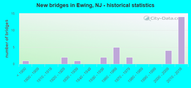
- New bridges - historical statistics
- 1Before 1900
- 21920-1929
- 11930-1939
- 21950-1959
- 51960-1969
- 21970-1979
- 42000-2009
- 142010-2019
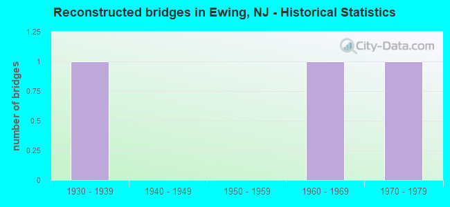
- Reconstructed bridges - Historical Statistics
- 11930-1939
- 01940-1949
- 01950-1959
- 11960-1969
- 11970-1979
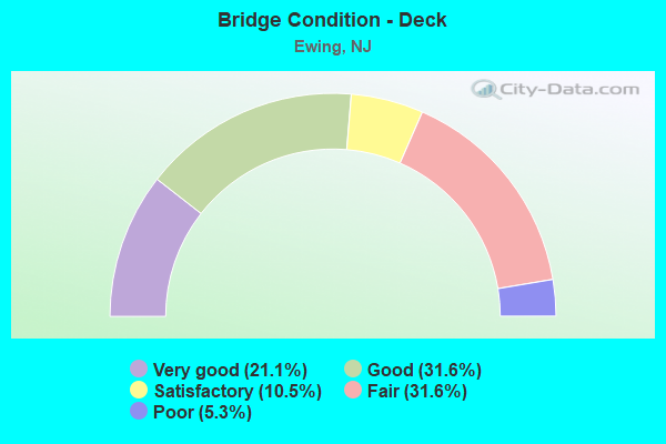
- Bridge Condition - Deck
- 21.1%Very good
- 31.6%Good
- 10.5%Satisfactory
- 31.6%Fair
- 5.3%Poor
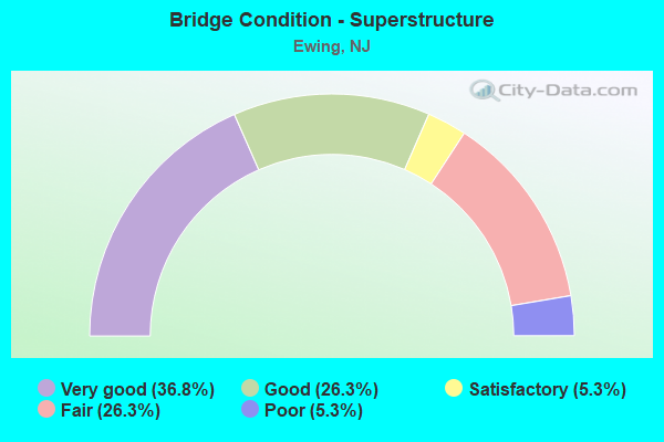
- Bridge Condition - Superstructure
- 36.8%Very good
- 26.3%Good
- 5.3%Satisfactory
- 26.3%Fair
- 5.3%Poor

- Bridge Condition - Substructure
- 42.1%Very good
- 26.3%Good
- 5.3%Satisfactory
- 21.1%Fair
- 5.3%Poor
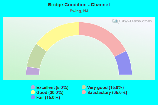
- Bridge Condition - Channel
- 5.0%Excellent
- 15.0%Very good
- 30.0%Good
- 35.0%Satisfactory
- 15.0%Fair
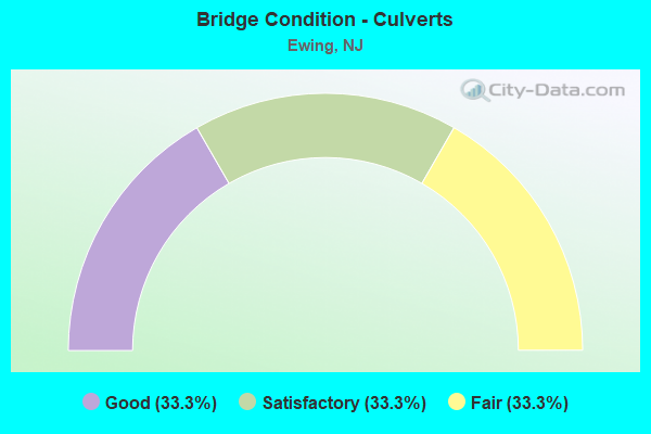
- Bridge Condition - Culverts
- 33.3%Good
- 33.3%Satisfactory
- 33.3%Fair
Find on map >> Show street view
Structure Number: 1100006, Location: 0.5 mile NW of US 206 (Lat: 40.248689, Lng: -74.756269), Route carried "on" structure: County highway 613, Year Built: 1950, Status: Open, Structure Length: 1.07m (3.51ft), Average Daily Traffic: 18,620 (year 2021), Truck Traffic: 4%, Average Future Daily Traffic: 22,720 (year 2041), Features Intersected: BRANCH SHABAKUNK CREEK
Minimum Vertical Clearance: 30+ m (98+ ft), Kilometerpoint: 0.885, Lanes on structure: 2, Owner: County Highway Agency, Approaching Roadway Width: 11.6m (38.1ft), Material/Design: Steel, Design/Construction: Stringer/Multi-beam, Number Of Spans In Main Unit: 1, Length of Maximum Span: 9.8m (32.2ft), Curb or Sidewalk Widths: Left: 3.0m (9.8ft), Right: 3.0m (9.8ft), Curb-To-Curb Width: 11.6m (38.1ft), Out-to-Out Width: 18.3m (60.0ft)
Condition: Deck: Fair, Superstructure: Fair, Substructure: Fair, Channel: Fair, Operating Rating: 39.9 metric tons, Method Used To Determine Operating Rating: Load Factor (LF), Inventory Rating: 23.6 metric tons, Method Used To Determine Inventory Rating: Load Factor (LF), Structural Evaluation: Somewhat better than minimum adequacy, Deck Geometry: Somewhat better than minimum adequacy, Waterway Adequacy: Equal to present desirable criteria, Approach Roadway Alignment: Equal to present desirable criteria, Length Of Structure Improvement: 1.07m (3.51ft), Designated Inspection Frequency: Every 24 months, Inspection Date: January 2021, Bridge Improvement Cost: $78,000, Total Project Cost: $247,000 ( Estimate for 2021), Deck Structure Type: Concrete Cast-file-Place, Wearing Surface/Protective System: Wearing Surface: Monolithic Concrete
Find on map >> Show street view
Structure Number: 1100009, Location: 0.23 mile S. of Olden Ave (Lat: 40.243369, Lng: -74.767150), Route carried "on" structure: County highway 627, Year Built: 1930, Status: Open, Structure Length: 0.73m (2.40ft), Average Daily Traffic: 14,190 (year 2021), Truck Traffic: 4%, Average Future Daily Traffic: 17,315 (year 2041), Features Intersected: SHABAKUNK CREEK, Facility Carried by Structure: PROSPECT STREET
Minimum Vertical Clearance: 30+ m (98+ ft), Kilometerpoint: 0.724, Lanes on structure: 2, Owner: County Highway Agency, Approaching Roadway Width: 11.6m (38.1ft), Material/Design: Steel, Design/Construction: Stringer/Multi-beam, Number Of Spans In Main Unit: 1, Length of Maximum Span: 6.7m (22.0ft), Curb or Sidewalk Widths: Left: 2.7m (8.9ft), Right: 2.7m (8.9ft), Curb-To-Curb Width: 11.6m (38.1ft), Out-to-Out Width: 17.7m (58.1ft)
Condition: Deck: Fair, Superstructure: Fair, Substructure: Poor, Channel: Satisfactory, Operating Rating: 69.9 metric tons, Method Used To Determine Operating Rating: Load Factor (LF), Inventory Rating: 41.7 metric tons, Method Used To Determine Inventory Rating: Load Factor (LF), Structural Evaluation: Meets minimum limits, Deck Geometry: Somewhat better than minimum adequacy, Waterway Adequacy: Equal to present minimum criteria, Approach Roadway Alignment: Equal to present desirable criteria, Length Of Structure Improvement: 1.34m (4.40ft), Designated Inspection Frequency: Every 24 months, Inspection Date: January 2021, Bridge Improvement Cost: $893,000, Roadway Improvement Cost: $114,000, Total Project Cost: $1,353,000 ( Estimate for 2021), Deck Structure Type: Concrete Cast-file-Place, Wearing Surface/Protective System: Wearing Surface: Bituminous
Find on map >> Show street view
Structure Number: 110001, Location: 1 Mi. North of US Route 1 (Lat: 40.245081, Lng: -74.761261), Route carried "on" structure: County highway 622, Year Built: 2014, Status: Open, Structure Length: 0.70m (2.30ft), Average Daily Traffic: 25,990 (year 2021), Truck Traffic: 4%, Average Future Daily Traffic: 31,715 (year 2041), Design Load: HL 93, Features Intersected: SHABAKUNK CREEK
Minimum Vertical Clearance: 30+ m (98+ ft), Kilometerpoint: 7.580, Lanes on structure: 5, Owner: County Highway Agency, Approaching Roadway Width: 18.6m (61.0ft), Material/Design: Prestressed concrete, Design/Construction: Stringer/Multi-beam, Number Of Spans In Main Unit: 1, Length of Maximum Span: 6.7m (22.0ft), Curb or Sidewalk Widths: Left: 1.8m (5.9ft), Right: 3.4m (11.2ft), Curb-To-Curb Width: 18.6m (61.0ft), Out-to-Out Width: 24.4m (80.1ft)
Condition: Deck: Very good, Superstructure: Very good, Substructure: Very good, Channel: Good, Operating Rating: 64.2 metric tons, Method Used To Determine Operating Rating: Load and Resistance Factor Rating (LRFR) rating reported by rating factor(RF) method using HL-93 loadings, Inventory Rating: 49.6 metric tons, Method Used To Determine Inventory Rating: Load and Resistance Factor Rating (LRFR) rating reported by rating factor(RF) method using HL-93 loadings, Structural Evaluation: Equal to present desirable criteria, Deck Geometry: High priority of corrective action, Waterway Adequacy: Equal to present minimum criteria, Approach Roadway Alignment: Equal to present desirable criteria, Designated Inspection Frequency: Every 24 months, Inspection Date: January 2021, Deck Structure Type: Concrete Cast-file-Place, Wearing Surface/Protective System: Wearing Surface: Integral Concrete, Deck Protection: Epoxy Coated Reinforcing
Find on map >> Show street view
Structure Number: 1100011, Location: 100' N. of CR 648 (Lat: 40.263211, Lng: -74.759831), Route carried "on" structure: County highway 636, Year Built: 2009, Status: Open, Structure Length: 0.94m (3.08ft), Average Daily Traffic: 15,510 (year 2021), Truck Traffic: 4%, Average Future Daily Traffic: 18,920 (year 2041), Design Load: HL 93, Features Intersected: E.BRANCH SHABAKUNK CREEK
Minimum Vertical Clearance: 30+ m (98+ ft), Kilometerpoint: 4.458, Lanes on structure: 2, Owner: County Highway Agency, Approaching Roadway Width: 13.4m (44.0ft), Material/Design: Prestressed concrete, Design/Construction: Stringer/Multi-beam, Number Of Spans In Main Unit: 1, Length of Maximum Span: 7.9m (25.9ft), Curb or Sidewalk Widths: Left: 1.8m (5.9ft), Right: 1.8m (5.9ft), Curb-To-Curb Width: 13.4m (44.0ft), Out-to-Out Width: 17.7m (58.1ft)
Condition: Deck: Satisfactory, Superstructure: Good, Substructure: Good, Channel: Fair, Operating Rating: 85.5 metric tons, Method Used To Determine Operating Rating: Load and Resistance Factor Rating (LRFR) rating reported by rating factor(RF) method using HL-93 loadings, Inventory Rating: 65.8 metric tons, Method Used To Determine Inventory Rating: Load and Resistance Factor Rating (LRFR) rating reported by rating factor(RF) method using HL-93 loadings, Structural Evaluation: Better than present minimum criteria, Deck Geometry: Equal to present minimum criteria, Waterway Adequacy: Meets minimum limits, Approach Roadway Alignment: Equal to present desirable criteria, Designated Inspection Frequency: Every 24 months, Inspection Date: Febuary 2021, Deck Structure Type: Concrete Cast-file-Place, Wearing Surface/Protective System: Deck Protection: Epoxy Coated Reinforcing
Find on map >> Show street view
Structure Number: 1100012, Location: 0.35M South of NJ RT.31 (Lat: 40.275689, Lng: -74.774311), Route carried "on" structure: County highway 636, Year Built: 2000, Status: Open, Structure Length: 0.94m (3.08ft), Average Daily Traffic: 13,610 (year 2021), Truck Traffic: 4%, Average Future Daily Traffic: 16,332 (year 2041), Design Load: HS 25 or greater, Features Intersected: Shabakunk Creek, Facility Carried by Structure: Ewingville Road
Minimum Vertical Clearance: 30+ m (98+ ft), Kilometerpoint: 6.534, Lanes on structure: 2, Owner: County Highway Agency, Approaching Roadway Width: 15.2m (49.9ft), Material/Design: Prestressed concrete, Design/Construction: Box Beam or Girders - Single/Spread, Number Of Spans In Main Unit: 1, Length of Maximum Span: 9.1m (29.9ft), Curb or Sidewalk Widths: Left: 3.0m (9.8ft), Right: 0.0m, Curb-To-Curb Width: 15.2m (49.9ft), Out-to-Out Width: 18.9m (62.0ft)
Condition: Deck: Good, Superstructure: Very good, Substructure: Good, Channel: Satisfactory, Operating Rating: 59.0 metric tons, Method Used To Determine Operating Rating: Load Factor (LF), Inventory Rating: 35.4 metric tons, Method Used To Determine Inventory Rating: Load Factor (LF), Structural Evaluation: Better than present minimum criteria, Deck Geometry: Superior to present desirable criteria, Waterway Adequacy: Equal to present minimum criteria, Approach Roadway Alignment: Better than present minimum criteria, Designated Inspection Frequency: Every 24 months, Inspection Date: Febuary 2021, Deck Structure Type: Concrete Cast-file-Place, Wearing Surface/Protective System: Wearing Surface: Monolithic Concrete, Deck Protection: Epoxy Coated Reinforcing
Find on map >> Show street view
Structure Number: 1104416, Location: 0.6 mile West of Rt. 31 (Lat: 40.269031, Lng: -74.793950), Route carried "on" structure: Other road , Year Built: 2013, Status: Open, Structure Length: 0.70m (2.30ft), Average Daily Traffic: 1,000 (year 2021), Truck Traffic: 3%, Average Future Daily Traffic: 1,220 (year 2041), Design Load: HL 93, Features Intersected: WEST BR. SHABAKUNK CRK, Facility Carried by Structure: CARLTON AVENUE
Minimum Vertical Clearance: 30+ m (98+ ft), Kilometerpoint: 0.982, Lanes on structure: 2, Owner: County Highway Agency, Approaching Roadway Width: 7.9m (25.9ft), Material/Design: Concrete, Design/Construction: Frame, Number Of Spans In Main Unit: 1, Length of Maximum Span: 6.7m (22.0ft), Curb or Sidewalk Widths: Left: 0.0m, Right: 1.5m (4.9ft), Curb-To-Curb Width: 7.9m (25.9ft), Out-to-Out Width: 10.5m (34.4ft)
Condition: Deck: Good, Superstructure: Good, Substructure: Very good, Channel: Satisfactory, Operating Rating: 63.5 metric tons, Method Used To Determine Operating Rating: Load and Resistance Factor Rating (LRFR) rating reported by rating factor(RF) method using HL-93 loadings, Inventory Rating: 38.6 metric tons, Method Used To Determine Inventory Rating: Load and Resistance Factor Rating (LRFR) rating reported by rating factor(RF) method using HL-93 loadings, Structural Evaluation: Better than present minimum criteria, Deck Geometry: Somewhat better than minimum adequacy, Waterway Adequacy: Better than present minimum criteria, Approach Roadway Alignment: Equal to present desirable criteria, Designated Inspection Frequency: Every 24 months, Inspection Date: March 2021, Deck Structure Type: Concrete Cast-file-Place, Wearing Surface/Protective System: Wearing Surface: Monolithic Concrete, Deck Protection: Epoxy Coated Reinforcing
Find on map >> Show street view
Structure Number: 1104422, Location: 0.6 MI EAST OF RTE 31 (Lat: 40.266331, Lng: -74.771061), Route carried "on" structure: Other road , Year Built: 2009, Status: Open, Structure Length: 0.88m (2.89ft), Average Daily Traffic: 3,120 (year 2021), Truck Traffic: 3%, Average Future Daily Traffic: 3,810 (year 2041), Design Load: HL 93, Features Intersected: SHABAKUNK CREEK, Facility Carried by Structure: GREEN LANE
Minimum Vertical Clearance: 30+ m (98+ ft), Kilometerpoint: 0.982, Lanes on structure: 2, Owner: County Highway Agency, Approaching Roadway Width: 11.0m (36.1ft), Skew: 1 degrees, Material/Design: Concrete, Design/Construction: Frame, Number Of Spans In Main Unit: 1, Length of Maximum Span: 7.9m (25.9ft), Curb or Sidewalk Widths: Left: 1.7m (5.6ft), Right: 1.6m (5.2ft), Curb-To-Curb Width: 11.0m (36.1ft), Out-to-Out Width: 15.2m (49.9ft)
Condition: Deck: Satisfactory, Superstructure: Good, Substructure: Good, Channel: Good, Operating Rating: 57.2 metric tons, Method Used To Determine Operating Rating: Load Factor (LF), Inventory Rating: 43.5 metric tons, Method Used To Determine Inventory Rating: Load Factor (LF), Structural Evaluation: Better than present minimum criteria, Deck Geometry: Somewhat better than minimum adequacy, Waterway Adequacy: Better than present minimum criteria, Approach Roadway Alignment: Equal to present desirable criteria, Designated Inspection Frequency: Every 24 months, Inspection Date: March 2021, Deck Structure Type: Concrete Cast-file-Place, Wearing Surface/Protective System: Wearing Surface: Monolithic Concrete, Membrane: Epoxy, Deck Protection: Epoxy Coated Reinforcing
Find on map >> Show street view
Structure Number: 1109151, Location: 0.27 MI NORTH OF I-95 JCT (Lat: 40.263261, Lng: -74.846631), Route carried "on" structure: State highway 29, Year Built: 1960, Year Reconstructed: 1984, Status: Open, Structure Length: 12.56m (41.21ft), Average Daily Traffic: 8,649 (year 2020), Truck Traffic: 5%, Average Future Daily Traffic: 10,379 (year 2040), Design Load: HS 20+Mod, Features Intersected: NJ 175&D&R CANAL FEEDER
Minimum Vertical Clearance: 30+ m (98+ ft), Kilometerpoint: 15.128, Lanes on structure: 2, Lanes under structure: 2, Base Highway Network: Yes, Owner: State Highway Agency, Approaching Roadway Width: 10.1m (33.1ft), Skew: 5 degrees, Material/Design: Steel, Design/Construction: Stringer/Multi-beam, Number Of Spans In Main Unit: 3, Number Of Approach Spans: 2, Length of Maximum Span: 31.4m (103.0ft), Curb-To-Curb Width: 10.2m (33.5ft), Out-to-Out Width: 11.7m (38.4ft)
Condition: Deck: Poor, Superstructure: Poor, Substructure: Fair, Channel: Very good, Operating Rating: 82.6 metric tons, Method Used To Determine Operating Rating: Load Factor (LF), Inventory Rating: 49.0 metric tons, Method Used To Determine Inventory Rating: Load Factor (LF), Structural Evaluation: Meets minimum limits, Deck Geometry: Meets minimum limits, Underclear: Equal to present minimum criteria, Waterway Adequacy: Superior to present desirable criteria, Approach Roadway Alignment: Equal to present minimum criteria, Length Of Structure Improvement: 12.56m (41.21ft), Designated Inspection Frequency: Every 24 months, Underwater Inspection Frequency: Every 48 months, Inspection Date: August 2020, Underwater Inspection Date: April 2020, Bridge Improvement Cost: $2,934,000, Roadway Improvement Cost: $280,000, Total Project Cost: $4,795,000 ( Estimate for 2018), Deck Structure Type: Concrete Cast-file-Place, Wearing Surface/Protective System: Wearing Surface: Monolithic Concrete
Find on map >> Show street view
Structure Number: 1110152, Location: 1.40 MI N OF I-95 JCT (Lat: 40.278300, Lng: -74.853381), Route carried "on" structure: State highway 29, Year Built: 1832, Year Reconstructed: 1941, Status: Open, Structure Length: 0.76m (2.49ft), Average Daily Traffic: 14,561 (year 2020), Truck Traffic: 4%, Average Future Daily Traffic: 19,598 (year 2040), Features Intersected: JACOBS CREEK
Minimum Vertical Clearance: 30+ m (98+ ft), Kilometerpoint: 16.882, Lanes on structure: 2, Base Highway Network: Yes, Owner: State Highway Agency, Approaching Roadway Width: 8.2m (26.9ft), Material/Design: Masonry, Design/Construction: Culvert, Number Of Spans In Main Unit: 1, Length of Maximum Span: 7.6m (24.9ft)
Condition: Channel: Satisfactory, Culverts: Fair, Operating Rating: 41.7 metric tons, Method Used To Determine Operating Rating: Field evaluation and documented engineering judgment, Inventory Rating: 25.4 metric tons, Method Used To Determine Inventory Rating: Field evaluation and documented engineering judgment, Structural Evaluation: Somewhat better than minimum adequacy, Waterway Adequacy: Superior to present desirable criteria, Approach Roadway Alignment: Equal to present minimum criteria, Designated Inspection Frequency: Every 24 months, Inspection Date: July 2020
Find on map >> Show street view
Structure Number: 111815, Location: 160 FT S OF OLDEN AVE EXT (Lat: 40.249411, Lng: -74.775481), Route carried "on" structure: State highway 31, Year Built: 1926, Year Reconstructed: 1967, Status: Open, Structure Length: 0.73m (2.40ft), Average Daily Traffic: 8,586 (year 2020), Truck Traffic: 4%, Average Future Daily Traffic: 10,476 (year 2040), Features Intersected: WEST BR SHABAKUNK CREEK
Minimum Vertical Clearance: 30+ m (98+ ft), Kilometerpoint: 2.881, Lanes on structure: 4, Base Highway Network: Yes, Owner: State Highway Agency, Approaching Roadway Width: 14.0m (45.9ft), Material/Design: Concrete, Design/Construction: Slab, Number Of Spans In Main Unit: 1, Length of Maximum Span: 5.5m (18.0ft), Curb or Sidewalk Widths: Left: 3.0m (9.8ft), Right: 8.3m (27.2ft), Curb-To-Curb Width: 14.0m (45.9ft), Out-to-Out Width: 26.0m (85.3ft)
Condition: Deck: Fair, Superstructure: Fair, Substructure: Satisfactory, Channel: Satisfactory, Operating Rating: 45.4 metric tons, Method Used To Determine Operating Rating: Field evaluation and documented engineering judgment, Inventory Rating: 32.7 metric tons, Method Used To Determine Inventory Rating: Field evaluation and documented engineering judgment, Structural Evaluation: Somewhat better than minimum adequacy, Deck Geometry: High priority of replacement, Waterway Adequacy: Equal to present desirable criteria, Approach Roadway Alignment: Equal to present desirable criteria, Length Of Structure Improvement: 0.70m (2.30ft), Designated Inspection Frequency: Every 24 months, Inspection Date: June 2020, Bridge Improvement Cost: $57,000, Roadway Improvement Cost: $16,000, Total Project Cost: $95,000 ( Estimate for 2020), Deck Structure Type: Concrete Cast-file-Place, Wearing Surface/Protective System: Wearing Surface: Bituminous
Find on map >> Show street view
Structure Number: 112015, Location: 0.2 MI N OF DELAWARE RIV. (Lat: 40.260711, Lng: -74.843811), Route carried "on" structure: Interstate 295, Year Built: 2019, Status: Open, Structure Length: 6.98m (22.90ft), Average Daily Traffic: 58,738 (year 2021), Truck Traffic: 9%, Average Future Daily Traffic: 70,486 (year 2041), Design Load: HL 93, Features Intersected: NJ 29NB,NJ 175, D&RCanal
Minimum Vertical Clearance: 30+ m (98+ ft), Kilometerpoint: 122.841, Lanes on structure: 7, Lanes under structure: 4, Base Highway Network: Yes, Owner: State Highway Agency, Approaching Roadway Width: 41.3m (135.5ft), Skew: 30 degrees, Material/Design: Steel, Design/Construction: Stringer/Multi-beam, Number Of Spans In Main Unit: 2, Length of Maximum Span: 50.3m (165.0ft), Curb-To-Curb Width: 41.3m (135.5ft), Out-to-Out Width: 43.1m (141.4ft)
Condition: Deck: Very good, Superstructure: Very good, Substructure: Very good, Channel: Excellent, Operating Rating: 42.1 metric tons, Method Used To Determine Operating Rating: Assigned ratings based on Load and Resistance Factor Design (LRFD) reported by rating factor (RF) using HL93 loadings, Inventory Rating: 32.4 metric tons, Method Used To Determine Inventory Rating: Assigned ratings based on Load and Resistance Factor Design (LRFD) reported by rating factor (RF) using HL93 loadings, Structural Evaluation: Equal to present desirable criteria, Deck Geometry: Superior to present desirable criteria, Underclear: Equal to present minimum criteria, Waterway Adequacy: Superior to present desirable criteria, Approach Roadway Alignment: Better than present minimum criteria, Designated Inspection Frequency: Every 24 months, Inspection Date: July 2021, Deck Structure Type: Concrete Cast-file-Place, Wearing Surface/Protective System: Wearing Surface: Latex Concrete, Membrane: Epoxy, Deck Protection: Epoxy Coated Reinforcing
Find on map >> Show street view
Structure Number: 1120151, Location: 1.5MI NORTH OF DELAWARE R (Lat: 40.276850, Lng: -74.828231), Route carried "on" structure: County highway 579, Year Built: 1960, Status: Open, Structure Length: 4.63m (15.19ft), Average Daily Traffic: 21,165 (year 2021), Truck Traffic: 4%, Average Future Daily Traffic: 25,398 (year 2041), Design Load: HS 20+Mod, Features Intersected: I-295
Minimum Vertical Clearance: 30+ m (98+ ft), Kilometerpoint: 5.021, Lanes on structure: 2, Lanes under structure: 7, Owner: State Highway Agency, Approaching Roadway Width: 14.0m (45.9ft), Material/Design: Steel, Design/Construction: Stringer/Multi-beam, Number Of Spans In Main Unit: 2, Length of Maximum Span: 22.6m (74.1ft), Curb or Sidewalk Widths: Left: 1.8m (5.9ft), Right: 1.8m (5.9ft), Curb-To-Curb Width: 14.0m (45.9ft), Out-to-Out Width: 18.4m (60.4ft)
Condition: Deck: Fair, Superstructure: Satisfactory, Substructure: Good, Operating Rating: 74.4 metric tons, Method Used To Determine Operating Rating: Load Factor (LF), Inventory Rating: 44.5 metric tons, Method Used To Determine Inventory Rating: Load Factor (LF), Structural Evaluation: Equal to present minimum criteria, Deck Geometry: Superior to present desirable criteria, Underclear: High priority of corrective action, Approach Roadway Alignment: Better than present minimum criteria, Length Of Structure Improvement: 4.63m (15.19ft), Designated Inspection Frequency: Every 24 months, Inspection Date: March 2021, Bridge Improvement Cost: $629,000, Roadway Improvement Cost: $204,000, Total Project Cost: $1,530,000 ( Estimate for 2019), Deck Structure Type: Concrete Cast-file-Place, Wearing Surface/Protective System: Wearing Surface: Latex Concrete
Find on map >> Show street view
Structure Number: 1120152, Location: 0.81 MI N OF I-295 EXT 75 (Lat: 40.285000, Lng: -74.818331), Route carried "on" structure: Interstate 295, Year Built: 1960, Status: Open, Structure Length: 1.22m (4.00ft), Average Daily Traffic: 88,161 (year 2019), Truck Traffic: 9%, Average Future Daily Traffic: 105,793 (year 2039), Design Load: HS 20, Features Intersected: EWING CREEK
Minimum Vertical Clearance: 30+ m (98+ ft), Kilometerpoint: 119.397, Lanes on structure: 6, Base Highway Network: Yes, Owner: State Highway Agency, Approaching Roadway Width: 33.5m (109.9ft), Skew: 24 degrees, Material/Design: Concrete, Design/Construction: Culvert, Number Of Spans In Main Unit: 1, Length of Maximum Span: 10.4m (34.1ft), Out-to-Out Width: 96.9m (317.9ft)
Condition: Channel: Good, Culverts: Satisfactory, Structural Evaluation: Equal to present minimum criteria, Waterway Adequacy: Superior to present desirable criteria, Approach Roadway Alignment: Equal to present desirable criteria, Designated Inspection Frequency: Every 24 months, Inspection Date: September 2021
Find on map >> Show street view
Structure Number: 1120154, Location: 0.12 MI S OF I-295 (Lat: 40.286669, Lng: -74.811669), Route carried "on" structure: County highway 611, Year Built: 2003, Status: Open, Structure Length: 0.70m (2.30ft), Average Daily Traffic: 9,685 (year 2021), Truck Traffic: 4%, Average Future Daily Traffic: 11,622 (year 2041), Features Intersected: EWING CREEK
Minimum Vertical Clearance: 30+ m (98+ ft), Kilometerpoint: 3.331, Lanes on structure: 5, Owner: State Highway Agency, Approaching Roadway Width: 14.6m (47.9ft), Skew: 2 degrees, Material/Design: Concrete, Design/Construction: Culvert, Number Of Spans In Main Unit: 1, Length of Maximum Span: 7.0m (23.0ft)
Condition: Channel: Good, Culverts: Good, Operating Rating: 89.8 metric tons, Method Used To Determine Operating Rating: Field evaluation and documented engineering judgment, Inventory Rating: 89.8 metric tons, Method Used To Determine Inventory Rating: Field evaluation and documented engineering judgment, Structural Evaluation: Better than present minimum criteria, Waterway Adequacy: Superior to present desirable criteria, Approach Roadway Alignment: Equal to present desirable criteria, Designated Inspection Frequency: Every 24 months, Inspection Date: September 2021
Find on map >> Show street view
Structure Number: 1120157, Location: 0.73 MI N OF RT 31 JCT (Lat: 40.289361, Lng: -74.798211), Route carried "on" structure: County highway 643, Year Built: 1973, Status: Open, Structure Length: 5.43m (17.81ft), Average Daily Traffic: 7,219 (year 2021), Truck Traffic: 3%, Average Future Daily Traffic: 8,662 (year 2041), Design Load: HS 20+Mod, Features Intersected: I-295, Facility Carried by Structure: LOWER FERRY ROAD
Minimum Vertical Clearance: 30+ m (98+ ft), Kilometerpoint: 6.518, Lanes on structure: 2, Lanes under structure: 6, Owner: State Highway Agency, Approaching Roadway Width: 12.2m (40.0ft), Material/Design: Steel, Design/Construction: Stringer/Multi-beam, Number Of Spans In Main Unit: 2, Length of Maximum Span: 26.2m (86.0ft), Curb or Sidewalk Widths: Left: 1.8m (5.9ft), Right: 1.8m (5.9ft), Curb-To-Curb Width: 12.2m (40.0ft), Out-to-Out Width: 16.5m (54.1ft)
Condition: Deck: Good, Superstructure: Good, Substructure: Good, Inventory Rating: 55.3 metric tons, Method Used To Determine Inventory Rating: Load Factor (LF), Structural Evaluation: Better than present minimum criteria, Deck Geometry: Somewhat better than minimum adequacy, Underclear: Meets minimum limits, Approach Roadway Alignment: Equal to present desirable criteria, Designated Inspection Frequency: Every 24 months, Inspection Date: September 2021, Deck Structure Type: Concrete Cast-file-Place, Wearing Surface/Protective System: Wearing Surface: Monolithic Concrete
Find on map >> Show street view
Structure Number: 1120172, Location: 0.2 MI N of Delaware Riv. (Lat: 40.261439, Lng: -74.843650), Route carried "on" structure: Ramp Interstate 295, Year Built: 2019, Status: Open, Structure Length: 7.44m (24.41ft), Average Daily Traffic: 4,400 (year 2021), Truck Traffic: 4%, Average Future Daily Traffic: 5,280 (year 2041), Design Load: HL 93, Features Intersected: NJ29 NB, D&RCanal
Minimum Vertical Clearance: 30+ m (98+ ft), Kilometerpoint: 0.000, Lanes on structure: 1, Lanes under structure: 3, Base Highway Network: Yes, Owner: State Highway Agency, Approaching Roadway Width: 9.8m (32.2ft), Material/Design: Steel, Design/Construction: Stringer/Multi-beam, Number Of Spans In Main Unit: 3, Length of Maximum Span: 39.0m (128.0ft), Curb-To-Curb Width: 9.4m (30.8ft), Out-to-Out Width: 10.6m (34.8ft)
Condition: Deck: Very good, Superstructure: Very good, Substructure: Very good, Channel: Very good, Operating Rating: 42.1 metric tons, Method Used To Determine Operating Rating: Assigned ratings based on Load and Resistance Factor Design (LRFD) reported by rating factor (RF) using HL93 loadings, Inventory Rating: 32.4 metric tons, Method Used To Determine Inventory Rating: Assigned ratings based on Load and Resistance Factor Design (LRFD) reported by rating factor (RF) using HL93 loadings, Structural Evaluation: Equal to present desirable criteria, Deck Geometry: Superior to present desirable criteria, Underclear: Equal to present minimum criteria, Waterway Adequacy: Superior to present desirable criteria, Approach Roadway Alignment: Equal to present desirable criteria, Designated Inspection Frequency: Every 24 months, Inspection Date: July 2021, Deck Structure Type: Concrete Cast-file-Place, Wearing Surface/Protective System: Wearing Surface: Latex Concrete, Membrane: Epoxy, Deck Protection: Epoxy Coated Reinforcing
Find on map >> Show street view
Structure Number: 1120173, Location: 0.2 MI N of DELAWARE RIV. (Lat: 40.260131, Lng: -74.843361), Route carried "on" structure: Ramp Interstate 295, Year Built: 2019, Status: Open, Structure Length: 11.13m (36.52ft), Average Daily Traffic: 1,800 (year 2021), Truck Traffic: 4%, Average Future Daily Traffic: 2,160 (year 2041), Design Load: HL 93, Features Intersected: NJ29 NB,NJ 175, D&RCanal
Minimum Vertical Clearance: 30+ m (98+ ft), Kilometerpoint: 0.000, Lanes on structure: 1, Lanes under structure: 3, Base Highway Network: Yes, Owner: State Highway Agency, Approaching Roadway Width: 8.8m (28.9ft), Skew: 30 degrees, Material/Design: Steel, Design/Construction: Stringer/Multi-beam, Number Of Spans In Main Unit: 2, Length of Maximum Span: 55.8m (183.1ft), Curb-To-Curb Width: 8.9m (29.2ft), Out-to-Out Width: 10.1m (33.1ft)
Condition: Deck: Very good, Superstructure: Very good, Substructure: Very good, Channel: Very good, Operating Rating: 42.1 metric tons, Method Used To Determine Operating Rating: Assigned ratings based on Load and Resistance Factor Design (LRFD) reported by rating factor (RF) using HL93 loadings, Inventory Rating: 32.4 metric tons, Method Used To Determine Inventory Rating: Assigned ratings based on Load and Resistance Factor Design (LRFD) reported by rating factor (RF) using HL93 loadings, Structural Evaluation: Equal to present desirable criteria, Deck Geometry: Superior to present desirable criteria, Underclear: Meets minimum limits, Waterway Adequacy: Superior to present desirable criteria, Approach Roadway Alignment: Equal to present desirable criteria, Designated Inspection Frequency: Every 24 months, Inspection Date: July 2021, Deck Structure Type: Concrete Cast-file-Place, Wearing Surface/Protective System: Wearing Surface: Latex Concrete, Membrane: Epoxy, Deck Protection: Epoxy Coated Reinforcing
Find on map >> Show street view
Structure Number: 1124425, Location: 1.0 MI EAST OF RT 31 (Lat: 40.285081, Lng: -74.766539), Route carried "on" structure: City street , Year Built: 1959, Status: Open, Structure Length: 1.13m (3.71ft), Average Daily Traffic: 2,635 (year 2021), Truck Traffic: 3%, Average Future Daily Traffic: 3,162 (year 2041), Design Load: HS 20, Features Intersected: SHABAKUNK CREEK, Facility Carried by Structure: BULL RUN ROAD
Minimum Vertical Clearance: 30+ m (98+ ft), Kilometerpoint: 0.306, Lanes on structure: 2, Owner: County Highway Agency, Approaching Roadway Width: 10.1m (33.1ft), Skew: 2 degrees, Material/Design: Prestressed concrete, Design/Construction: Slab, Number Of Spans In Main Unit: 1, Length of Maximum Span: 10.1m (33.1ft), Curb or Sidewalk Widths: Left: 2.0m (6.6ft), Right: 2.0m (6.6ft), Curb-To-Curb Width: 13.4m (44.0ft), Out-to-Out Width: 17.4m (57.1ft)
Condition: Deck: Fair, Superstructure: Fair, Substructure: Fair, Channel: Fair, Operating Rating: 51.7 metric tons, Method Used To Determine Operating Rating: Field evaluation and documented engineering judgment, Inventory Rating: 30.8 metric tons, Method Used To Determine Inventory Rating: Field evaluation and documented engineering judgment, Structural Evaluation: Somewhat better than minimum adequacy, Deck Geometry: Better than present minimum criteria, Waterway Adequacy: Equal to present minimum criteria, Approach Roadway Alignment: Equal to present desirable criteria, Designated Inspection Frequency: Every 24 months, Inspection Date: Febuary 2021, Deck Structure Type: Concrete Precast Panels, Wearing Surface/Protective System: Wearing Surface: Bituminous
Find on map >> Show street view
Structure Number: 3001162, Location: 1000 FEET EAST OF NJ 29 (Lat: 40.244769, Lng: -74.819069), Route carried "on" structure: County highway 643, Year Built: 2013, Status: Open, Structure Length: 1.13m (3.71ft), Average Daily Traffic: 8,991 (year 2020), Truck Traffic: 4%, Average Future Daily Traffic: 10,971 (year 2040), Design Load: HL 93, Features Intersected: D&R CANAL FEEDER
Minimum Vertical Clearance: 30+ m (98+ ft), Kilometerpoint: 0.370, Lanes on structure: 2, Owner: State Agenciy, Maintenance Responsibility: State Highway Agency, Approaching Roadway Width: 8.2m (26.9ft), Skew: 2 degrees, Material/Design: Steel, Design/Construction: Stringer/Multi-beam, Number Of Spans In Main Unit: 1, Length of Maximum Span: 11.3m (37.1ft), Curb or Sidewalk Widths: Left: 1.8m (5.9ft), Right: 1.8m (5.9ft), Curb-To-Curb Width: 8.0m (26.2ft), Out-to-Out Width: 12.3m (40.4ft)
Condition: Deck: Good, Superstructure: Good, Substructure: Very good, Channel: Good, Operating Rating: 93.3 metric tons, Method Used To Determine Operating Rating: Load and Resistance Factor Rating (LRFR) rating reported by rating factor(RF) method using HL-93 loadings, Inventory Rating: 71.9 metric tons, Method Used To Determine Inventory Rating: Load and Resistance Factor Rating (LRFR) rating reported by rating factor(RF) method using HL-93 loadings, Structural Evaluation: Better than present minimum criteria, Deck Geometry: High priority of replacement, Waterway Adequacy: Equal to present desirable criteria, Approach Roadway Alignment: Equal to present minimum criteria, Designated Inspection Frequency: Every 24 months, Inspection Date: October 2020, Deck Structure Type: Wood or Timber, Wearing Surface/Protective System: Wearing Surface: Wood or Timber
Find on map >> Show street view
Structure Number: 3001164, Location: 1/2 MI EAST OF NJ 29 (Lat: 40.251789, Lng: -74.832569), Route carried "on" structure: City street , Year Built: 2012, Status: Open, Structure Length: 1.16m (3.81ft), Average Daily Traffic: 962 (year 2020), Truck Traffic: 3%, Average Future Daily Traffic: 1,155 (year 2040), Design Load: HL 93, Features Intersected: D&R CANAL FEEDER, Facility Carried by Structure: WILBURTHA ROAD
Minimum Vertical Clearance: 30+ m (98+ ft), Kilometerpoint: 1.336, Lanes on structure: 2, Owner: State Agenciy, Maintenance Responsibility: State Highway Agency, Approaching Roadway Width: 9.0m (29.5ft), Skew: 2 degrees, Material/Design: Steel, Design/Construction: Stringer/Multi-beam, Number Of Spans In Main Unit: 1, Length of Maximum Span: 11.6m (38.1ft), Curb or Sidewalk Widths: Left: 1.7m (5.6ft), Right: 1.7m (5.6ft), Curb-To-Curb Width: 9.0m (29.5ft), Out-to-Out Width: 13.0m (42.7ft)
Condition: Deck: Good, Superstructure: Very good, Substructure: Very good, Channel: Satisfactory, Operating Rating: 71.6 metric tons, Method Used To Determine Operating Rating: Load and Resistance Factor Rating (LRFR) rating reported by rating factor(RF) method using HL-93 loadings, Inventory Rating: 55.1 metric tons, Method Used To Determine Inventory Rating: Load and Resistance Factor Rating (LRFR) rating reported by rating factor(RF) method using HL-93 loadings, Structural Evaluation: Equal to present desirable criteria, Deck Geometry: Somewhat better than minimum adequacy, Waterway Adequacy: Equal to present desirable criteria, Approach Roadway Alignment: Equal to present minimum criteria, Designated Inspection Frequency: Every 24 months, Underwater Inspection Frequency: Every 48 months, Inspection Date: September 2020, Underwater Inspection Date: April 2020, Deck Structure Type: Wood or Timber
Find on map >> Show street view
Structure Number: 3001165, Location: 0.37 Mile N. of NJ 29 Jct (Lat: 40.256850, Lng: -74.837911), Route carried "on" structure: State highway 175, Year Built: 1920, Status: Open, Structure Length: 1.07m (3.51ft), Average Daily Traffic: 5,450 (year 2020), Truck Traffic: 4%, Average Future Daily Traffic: 6,650 (year 2040), Features Intersected: D&R Feeder Canal
Minimum Vertical Clearance: 30+ m (98+ ft), Kilometerpoint: 3.444, Lanes on structure: 2, Owner: State Agenciy, Maintenance Responsibility: State Highway Agency, Approaching Roadway Width: 9.1m (29.9ft), Material/Design: Concrete, Design/Construction: Tee Beam, Number Of Spans In Main Unit: 1, Length of Maximum Span: 10.1m (33.1ft), Curb or Sidewalk Widths: Left: 1.7m (5.6ft), Right: 1.7m (5.6ft), Curb-To-Curb Width: 9.1m (29.9ft), Out-to-Out Width: 13.0m (42.7ft)
Condition: Deck: Fair, Superstructure: Fair, Substructure: Fair, Channel: Satisfactory, Operating Rating: 43.5 metric tons, Method Used To Determine Operating Rating: Field evaluation and documented engineering judgment, Inventory Rating: 32.7 metric tons, Method Used To Determine Inventory Rating: Field evaluation and documented engineering judgment, Structural Evaluation: Somewhat better than minimum adequacy, Deck Geometry: High priority of corrective action, Waterway Adequacy: Equal to present desirable criteria, Approach Roadway Alignment: Better than present minimum criteria, Designated Inspection Frequency: Every 24 months, Underwater Inspection Frequency: Every 24 months, Inspection Date: May 2020, Underwater Inspection Date: April 2020, Deck Structure Type: Concrete Cast-file-Place, Wearing Surface/Protective System: Wearing Surface: Bituminous, Membrane: Epoxy
Find on map >> Show street view
Structure Number: 3001166, Location: .38MI NW OF RT29&I95 JCT (Lat: 40.265289, Lng: -74.847800), Route carried "on" structure: City street , Year Built: 2012, Status: Open, Structure Length: 1.28m (4.20ft), Average Daily Traffic: 144 (year 2021), Truck Traffic: 1%, Average Future Daily Traffic: 175 (year 2041), Design Load: HL 93, Features Intersected: D&R FEEDER CANAL, Facility Carried by Structure: BERNARD DRIVE
Minimum Vertical Clearance: 30+ m (98+ ft), Kilometerpoint: 0.000, Lanes on structure: 2, Owner: State Agenciy, Maintenance Responsibility: State Highway Agency, Approaching Roadway Width: 7.3m (24.0ft), Skew: 1 degrees, Material/Design: Steel, Design/Construction: Stringer/Multi-beam, Number Of Spans In Main Unit: 1, Length of Maximum Span: 11.9m (39.0ft), Curb or Sidewalk Widths: Left: 0.0m, Right: 1.2m (3.9ft), Curb-To-Curb Width: 7.5m (24.6ft), Out-to-Out Width: 9.4m (30.8ft)
Condition: Deck: Good, Superstructure: Very good, Substructure: Very good, Channel: Good, Operating Rating: 77.8 metric tons, Method Used To Determine Operating Rating: Load and Resistance Factor Rating (LRFR) rating reported by rating factor(RF) method using HL-93 loadings, Inventory Rating: 59.9 metric tons, Method Used To Determine Inventory Rating: Load and Resistance Factor Rating (LRFR) rating reported by rating factor(RF) method using HL-93 loadings, Structural Evaluation: Equal to present desirable criteria, Deck Geometry: Somewhat better than minimum adequacy, Waterway Adequacy: Equal to present desirable criteria, Approach Roadway Alignment: Equal to present desirable criteria, Designated Inspection Frequency: Every 24 months, Inspection Date: Febuary 2021, Deck Structure Type: Wood or Timber, Wearing Surface/Protective System: Wearing Surface: Wood or Timber
Find on map >> Show street view
Structure Number: 1109151, Location: 0.27 MI NORTH OF I-95 JCT (Lat: 40.263261, Lng: -74.846631), Route carried "under" structure: State highway 175, Year Built: 1960, Structure Length: 0. m, Average Daily Traffic: 2,610 (year 2020), Truck Traffic: 4%, Features Intersected: NJ 175&D&R CANAL FEEDER, Facility Carried by Structure: NJ 29
Minimum Vertical Clearance: 5.51m (18.08ft), Kilometerpoint: 4.748, Lanes on structure: 2, Lanes under structure: 2, Material/Design: Steel, Design/Construction: Stringer/Multi-beam, Length of Maximum Span: 31.4m (103.0ft)
Find on map >> Show street view
Structure Number: 112015, Location: 0.2 MI N OF DELAWARE RIV. (Lat: 40.260711, Lng: -74.843811), Route carried "under" structure: State highway 29, Year Built: 2019, Structure Length: 0. m, Average Daily Traffic: 13,063 (year 2021), Truck Traffic: 5%, Features Intersected: NJ 29NB,NJ 175, D&RCanal
Minimum Vertical Clearance: 4.22m (13.85ft), Kilometerpoint: 14.693, Lanes on structure: 7, Lanes under structure: 2, Material/Design: Steel, Design/Construction: Stringer/Multi-beam, Length of Maximum Span: 50.3m (165.0ft)
Find on map >> Show street view
Structure Number: 112015, Location: 0.2 MI N OF DELAWARE RIV. (Lat: 40.260711, Lng: -74.843811), Route carried "under" structure: State highway 175, Year Built: 2019, Structure Length: 0. m, Average Daily Traffic: 2,688 (year 2021), Truck Traffic: 4%, Features Intersected: NJ 29NB,NJ 175, D&RCanal, Facility Carried by Structure: ROUTE I-295
Minimum Vertical Clearance: 5.61m (18.41ft), Kilometerpoint: 4.136, Lanes on structure: 7, Lanes under structure: 2, Material/Design: Steel, Design/Construction: Stringer/Multi-beam, Length of Maximum Span: 50.3m (165.0ft)
Find on map >> Show street view
Structure Number: 1120151, Location: 1.5MI NORTH OF DELAWARE R (Lat: 40.276850, Lng: -74.828231), Route carried "under" structure: Interstate 295, Year Built: 1960, Structure Length: 0. m, Average Daily Traffic: 58,736 (year 2021), Truck Traffic: 9%, Features Intersected: I-295, Facility Carried by Structure: CR579(BEAR TAVERN)
Minimum Vertical Clearance: 5.21m (17.09ft), Kilometerpoint: 120.701, Lanes on structure: 2, Lanes under structure: 7, Material/Design: Steel, Design/Construction: Stringer/Multi-beam, Length of Maximum Span: 22.6m (74.1ft)
Find on map >> Show street view
Structure Number: 1120157, Location: 0.73 MI N OF RT 31 JCT (Lat: 40.289361, Lng: -74.798211), Route carried "under" structure: Interstate 295, Year Built: 1973, Structure Length: 0. m, Average Daily Traffic: 66,959 (year 2021), Truck Traffic: 9%, Features Intersected: I-295, Facility Carried by Structure: LOWER FERRY ROAD
Minimum Vertical Clearance: 5.21m (17.09ft), Kilometerpoint: 117.546, Lanes on structure: 2, Lanes under structure: 6, Material/Design: Steel, Design/Construction: Stringer/Multi-beam, Length of Maximum Span: 26.2m (86.0ft)
Find on map >> Show street view
Structure Number: 1120172, Location: 0.2 MI N of Delaware Riv. (Lat: 40.261439, Lng: -74.843650), Route carried "under" structure: State highway 29, Year Built: 2019, Structure Length: 0. m, Average Daily Traffic: 15,600 (year 2021), Truck Traffic: 4%, Features Intersected: NJ29 NB, D&RCanal
Minimum Vertical Clearance: 4.52m (14.83ft), Kilometerpoint: 14.693, Lanes on structure: 1, Lanes under structure: 1, Material/Design: Steel, Design/Construction: Stringer/Multi-beam, Length of Maximum Span: 39.0m (128.0ft)
Find on map >> Show street view
Structure Number: 1120172, Location: 0.2 MI N of Delaware Riv. (Lat: 40.261439, Lng: -74.843650), Route carried "under" structure: State highway 175, Year Built: 2019, Structure Length: 0. m, Average Daily Traffic: 4,900 (year 2021), Truck Traffic: 4%, Features Intersected: NJ29 NB, D&RCanal, Facility Carried by Structure: I-295 NB RAMP G
Minimum Vertical Clearance: 5.61m (18.41ft), Kilometerpoint: 4.136, Lanes on structure: 1, Lanes under structure: 2, Material/Design: Steel, Design/Construction: Stringer/Multi-beam, Length of Maximum Span: 39.0m (128.0ft)
Find on map >> Show street view
Structure Number: 1120173, Location: 0.2 MI N of DELAWARE RIV. (Lat: 40.260131, Lng: -74.843361), Route carried "under" structure: State highway 29, Year Built: 2019, Structure Length: 0. m, Average Daily Traffic: 15,600 (year 2021), Truck Traffic: 5%, Features Intersected: NJ29 NB,NJ 175, D&RCanal
Minimum Vertical Clearance: 5.99m (19.65ft), Kilometerpoint: 14.693, Lanes on structure: 1, Lanes under structure: 1, Material/Design: Steel, Design/Construction: Stringer/Multi-beam, Length of Maximum Span: 55.8m (183.1ft)
Find on map >> Show street view
Structure Number: 1120173, Location: 0.2 MI N of DELAWARE RIV. (Lat: 40.260131, Lng: -74.843361), Route carried "under" structure: State highway 175, Year Built: 2019, Structure Length: 0. m, Average Daily Traffic: 4,900 (year 2021), Truck Traffic: 4%, Features Intersected: NJ29 NB,NJ 175, D&RCanal, Facility Carried by Structure: I-295 SB RAMP C
Minimum Vertical Clearance: 6.02m (19.75ft), Kilometerpoint: 4.088, Lanes on structure: 1, Lanes under structure: 2, Material/Design: Steel, Design/Construction: Stringer/Multi-beam, Length of Maximum Span: 55.8m (183.1ft)