Bridge Statistics for Excelsior Springs, Missouri (MO)
Condition, Traffic, Stress, Structural Evaluation, Project Costs
- National Bridge Inventory (NBI) Statistics
- 34Number of bridges
- 344ft / 105mTotal length
- $2,832,000Total costs
- 91,705Total average daily traffic
- 5,874Total average daily truck traffic
- National Bridge Inventory (NBI) Registered Bridges for Excelsior Springs
- No street view available for this location
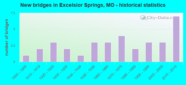
- New bridges - historical statistics
- 11900-1909
- 21910-1919
- 31920-1929
- 21930-1939
- 11940-1949
- 31950-1959
- 31960-1969
- 41970-1979
- 21980-1989
- 31990-1999
- 32000-2009
- 72010-2019
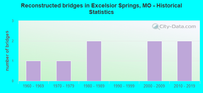
- Reconstructed bridges - Historical Statistics
- 11960-1969
- 11970-1979
- 21980-1989
- 01990-1999
- 22000-2009
- 22010-2019
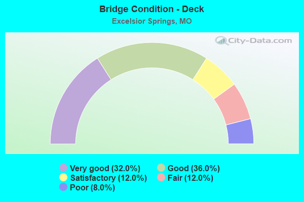
- Bridge Condition - Deck
- 32.0%Very good
- 36.0%Good
- 12.0%Satisfactory
- 12.0%Fair
- 8.0%Poor
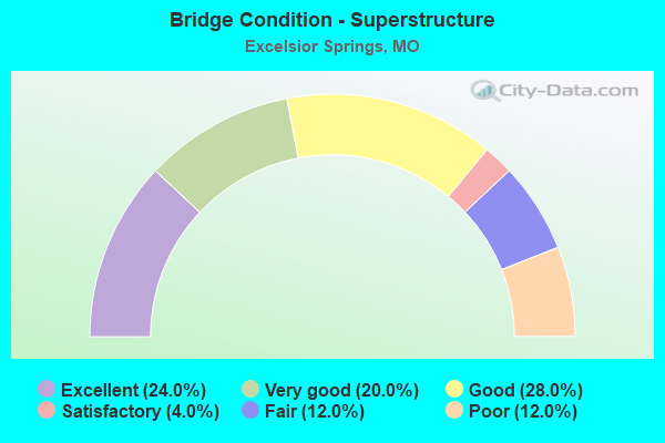
- Bridge Condition - Superstructure
- 24.0%Excellent
- 20.0%Very good
- 28.0%Good
- 4.0%Satisfactory
- 12.0%Fair
- 12.0%Poor
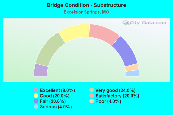
- Bridge Condition - Substructure
- 8.0%Excellent
- 24.0%Very good
- 20.0%Good
- 20.0%Satisfactory
- 20.0%Fair
- 4.0%Poor
- 4.0%Serious
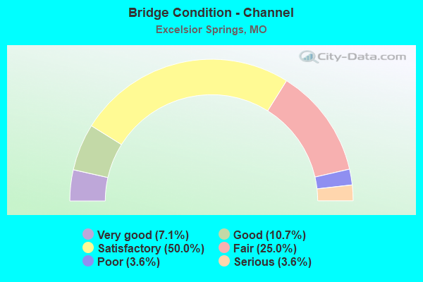
- Bridge Condition - Channel
- 7.1%Very good
- 10.7%Good
- 50.0%Satisfactory
- 25.0%Fair
- 3.6%Poor
- 3.6%Serious
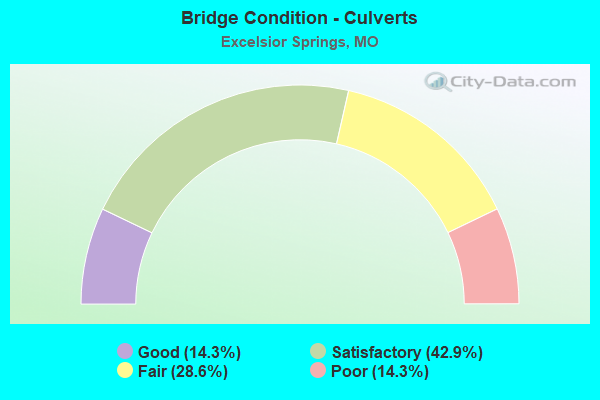
- Bridge Condition - Culverts
- 14.3%Good
- 42.9%Satisfactory
- 28.6%Fair
- 14.3%Poor
Find on map >> Show street view
Structure Number: 14433, Location: S 21 T 53 N R 30 W (Lat: 39.389211, Lng: -94.280725), Route carried "on" structure: County highway 67, Year Built: 1996, Status: Open, Structure Length: 4.72m (15.49ft), Average Daily Traffic: 270 (year 2020), Truck Traffic: 10%, Average Future Daily Traffic: 419 (year 2040), Features Intersected: C.R.I. & P. RR, Facility Carried by Structure: LAFOON RD
Minimum Vertical Clearance: 30+ m (98+ ft), Kilometerpoint: 3.058, Lanes on structure: 2, Owner: County Highway Agency, Approaching Roadway Width: 7.3m (24.0ft), Material/Design: Prestressed concrete continuous, Design/Construction: Stringer/Multi-beam, Number Of Spans In Main Unit: 3, Length of Maximum Span: 16.2m (53.1ft), Curb or Sidewalk Widths: Left: 0.4m (1.3ft), Right: 0.4m (1.3ft), Curb-To-Curb Width: 7.3m (24.0ft), Out-to-Out Width: 8.1m (26.6ft)
Condition: Deck: Good, Superstructure: Good, Substructure: Good, Operating Rating: 81.0 metric tons, Method Used To Determine Operating Rating: Load Factor (LF), Inventory Rating: 40.5 metric tons, Method Used To Determine Inventory Rating: Load Factor (LF), Structural Evaluation: Better than present minimum criteria, Deck Geometry: Somewhat better than minimum adequacy, Approach Roadway Alignment: Equal to present desirable criteria, Designated Inspection Frequency: Every 24 months, Inspection Date: December 2021, Deck Structure Type: Concrete Precast Panels, Wearing Surface/Protective System: Wearing Surface: Monolithic Concrete
Find on map >> Show street view
Structure Number: 14439, Location: S 21 T 53 N R 30 W (Lat: 39.384453, Lng: -94.269742), Route carried "on" structure: County highway 67, Year Built: 1971, Status: Posted for load, Structure Length: 1.40m (4.59ft), Average Daily Traffic: 270 (year 2020), Truck Traffic: 10%, Average Future Daily Traffic: 419 (year 2040), Features Intersected: WILLIAMS CR, Facility Carried by Structure: LAFOON RD
Minimum Vertical Clearance: 30+ m (98+ ft), Kilometerpoint: 4.184, Lanes on structure: 2, Owner: County Highway Agency, Approaching Roadway Width: 7.9m (25.9ft), Material/Design: Steel, Design/Construction: Stringer/Multi-beam, Number Of Spans In Main Unit: 1, Length of Maximum Span: 13.7m (44.9ft), Curb-To-Curb Width: 7.9m (25.9ft), Out-to-Out Width: 8.2m (26.9ft)
Condition: Deck: Fair, Superstructure: Fair, Substructure: Fair, Channel: Satisfactory, Operating Rating: 17.1 metric tons, Method Used To Determine Operating Rating: Allowable Stress (AS), Inventory Rating: 9.0 metric tons, Method Used To Determine Inventory Rating: Allowable Stress (AS), Structural Evaluation: High priority of replacement, Deck Geometry: Somewhat better than minimum adequacy, Waterway Adequacy: Better than present minimum criteria, Approach Roadway Alignment: Equal to present desirable criteria, Bridge Posting: Required (Relationship of Operating Rating to Maximum Legal Load: 30.0 - 39.9% below), Length Of Structure Improvement: 0.21m (0.69ft), Designated Inspection Frequency: Every 24 months, Inspection Date: December 2021, Bridge Improvement Cost: $190,000, Roadway Improvement Cost: $19,000, Total Project Cost: $286,000 ( Estimate for 2022), Deck Structure Type: Concrete Cast-file-Place, Wearing Surface/Protective System: Wearing Surface: Monolithic Concrete
Find on map >> Show street view
Structure Number: 1505, Location: S 14 T 53 N R 30 W (Lat: 39.397856, Lng: -94.236097), Route carried "on" structure: County highway 83, Year Built: 1991, Status: Open, Structure Length: 1.22m (4.00ft), Average Daily Traffic: 30 (year 2020), Truck Traffic: 10%, Average Future Daily Traffic: 47 (year 2040), Features Intersected: BR OF WILLIAMS CR, Facility Carried by Structure: BAXTER RD
Minimum Vertical Clearance: 30+ m (98+ ft), Kilometerpoint: 3.862, Lanes on structure: 2, Owner: County Highway Agency, Approaching Roadway Width: 7.3m (24.0ft), Material/Design: Steel, Design/Construction: Stringer/Multi-beam, Number Of Spans In Main Unit: 1, Length of Maximum Span: 11.9m (39.0ft), Curb-To-Curb Width: 8.1m (26.6ft), Out-to-Out Width: 8.5m (27.9ft)
Condition: Deck: Very good, Superstructure: Good, Substructure: Good, Channel: Satisfactory, Operating Rating: 54.9 metric tons, Method Used To Determine Operating Rating: Allowable Stress (AS), Inventory Rating: 36.0 metric tons, Method Used To Determine Inventory Rating: Allowable Stress (AS), Structural Evaluation: Better than present minimum criteria, Deck Geometry: Equal to present minimum criteria, Waterway Adequacy: Meets minimum limits, Approach Roadway Alignment: Equal to present minimum criteria, Designated Inspection Frequency: Every 24 months, Inspection Date: December 2021, Deck Structure Type: Concrete Cast-file-Place, Wearing Surface/Protective System: Wearing Surface: Monolithic Concrete
Find on map >> Show street view
Structure Number: 15385, Location: S 1 T 52 N R 30 W (Lat: 39.349422, Lng: -94.221600), Route carried "on" structure: County highway , Year Built: 1935, Year Reconstructed: 1987, Status: Posted for load, Structure Length: 1.40m (4.59ft), Average Daily Traffic: 1,000 (year 2020), Truck Traffic: 10%, Average Future Daily Traffic: 1,600 (year 2040), Features Intersected: BR OF FISHING RVR, Facility Carried by Structure: NE 143RD TERRACE
Minimum Vertical Clearance: 30+ m (98+ ft), Kilometerpoint: 4.184, Lanes on structure: 2, Owner: City or Municipal Highway Agency, Approaching Roadway Width: 6.7m (22.0ft), Material/Design: Steel, Design/Construction: Stringer/Multi-beam, Number Of Spans In Main Unit: 1, Length of Maximum Span: 13.4m (44.0ft), Curb-To-Curb Width: 6.7m (22.0ft), Out-to-Out Width: 6.9m (22.6ft)
Condition: Deck: Satisfactory, Superstructure: Poor, Substructure: Fair, Channel: Fair, Operating Rating: 16.2 metric tons, Method Used To Determine Operating Rating: Load Factor (LF), Inventory Rating: 9.9 metric tons, Method Used To Determine Inventory Rating: Load Factor (LF), Structural Evaluation: High priority of replacement, Deck Geometry: Meets minimum limits, Waterway Adequacy: Better than present minimum criteria, Approach Roadway Alignment: Equal to present minimum criteria, Bridge Posting: Required (Relationship of Operating Rating to Maximum Legal Load: 30.0 - 39.9% below), Length Of Structure Improvement: 0.21m (0.69ft), Designated Inspection Frequency: Every 24 months, Inspection Date: December 2021, Bridge Improvement Cost: $228,000, Roadway Improvement Cost: $23,000, Total Project Cost: $341,000 ( Estimate for 2022), Deck Structure Type: Concrete Cast-file-Place, Wearing Surface/Protective System: Wearing Surface: Monolithic Concrete
Find on map >> Show street view
Structure Number: 1551, Location: S 23 T 53 N R 30 W (Lat: 39.389478, Lng: -94.248617), Route carried "on" structure: County highway , Year Built: 1945, Year Reconstructed: 1966, Status: Posted for load, Structure Length: 0.88m (2.89ft), Average Daily Traffic: 314 (year 2020), Truck Traffic: 10%, Average Future Daily Traffic: 487 (year 2040), Features Intersected: BR OF WILLIAMS CR, Facility Carried by Structure: 164TH ST
Minimum Vertical Clearance: 30+ m (98+ ft), Kilometerpoint: 2.092, Lanes on structure: 2, Owner: County Highway Agency, Approaching Roadway Width: 8.5m (27.9ft), Material/Design: Steel, Design/Construction: Stringer/Multi-beam, Number Of Spans In Main Unit: 1, Length of Maximum Span: 8.2m (26.9ft), Curb-To-Curb Width: 7.7m (25.3ft), Out-to-Out Width: 8.3m (27.2ft)
Condition: Deck: Poor, Superstructure: Poor, Substructure: Fair, Channel: Fair, Operating Rating: 13.5 metric tons, Method Used To Determine Operating Rating: Allowable Stress (AS), Inventory Rating: 5.4 metric tons, Method Used To Determine Inventory Rating: Allowable Stress (AS), Structural Evaluation: High priority of replacement, Deck Geometry: Somewhat better than minimum adequacy, Waterway Adequacy: Better than present minimum criteria, Approach Roadway Alignment: High priority of corrective action, Bridge Posting: Required (Relationship of Operating Rating to Maximum Legal Load: > 39.9% below), Length Of Structure Improvement: 0.15m (0.49ft), Designated Inspection Frequency: Every 24 months, Inspection Date: December 2021, Bridge Improvement Cost: $135,000, Roadway Improvement Cost: $14,000, Total Project Cost: $203,000 ( Estimate for 2022), Deck Structure Type: Concrete Cast-file-Place, Wearing Surface/Protective System: Wearing Surface: Gravel
Find on map >> Show street view
Structure Number: 15739, Location: S 34 T 53 N R 30 W (Lat: 39.364156, Lng: -94.258336), Route carried "on" structure: County highway 98, Year Built: 1986, Status: Open, Structure Length: 0.79m (2.59ft), Average Daily Traffic: 105 (year 2020), Truck Traffic: 10%, Average Future Daily Traffic: 163 (year 2040), Features Intersected: BR OF WILLIAMS CR, Facility Carried by Structure: WATKINS RD
Minimum Vertical Clearance: 30+ m (98+ ft), Kilometerpoint: 0.805, Lanes on structure: 2, Owner: County Highway Agency, Approaching Roadway Width: 7.3m (24.0ft), Material/Design: Steel, Design/Construction: Culvert, Number Of Spans In Main Unit: 2, Length of Maximum Span: 3.4m (11.2ft), Curb-To-Curb Width: 7.8m (25.6ft), Out-to-Out Width: 7.8m (25.6ft)
Condition: Channel: Fair, Culverts: Poor, Operating Rating: 49.5 metric tons, Method Used To Determine Operating Rating: Allowable Stress (AS), Inventory Rating: 32.4 metric tons, Method Used To Determine Inventory Rating: Allowable Stress (AS), Structural Evaluation: Meets minimum limits, Deck Geometry: Somewhat better than minimum adequacy, Waterway Adequacy: Meets minimum limits, Approach Roadway Alignment: Equal to present minimum criteria, Length Of Structure Improvement: 0.14m (0.46ft), Designated Inspection Frequency: Every 24 months, Inspection Date: December 2021, Bridge Improvement Cost: $85,000, Roadway Improvement Cost: $9,000, Total Project Cost: $128,000 ( Estimate for 2022)
Find on map >> Show street view
Structure Number: 15797, Location: S 24 T 53 N R 30 W (Lat: 39.360481, Lng: -94.262411), Route carried "on" structure: County highway 100, Year Built: 1950, Status: Open, Structure Length: 0.70m (2.30ft), Average Daily Traffic: 1,055 (year 2020), Truck Traffic: 10%, Average Future Daily Traffic: 1,635 (year 2040), Features Intersected: BR OF WILLIAMS CR, Facility Carried by Structure: OLD QUARRY RD
Minimum Vertical Clearance: 30+ m (98+ ft), Kilometerpoint: 1.127, Lanes on structure: 2, Owner: County Highway Agency, Approaching Roadway Width: 7.3m (24.0ft), Material/Design: Concrete, Design/Construction: Culvert, Number Of Spans In Main Unit: 2, Length of Maximum Span: 3.4m (11.2ft)
Condition: Channel: Satisfactory, Culverts: Good, Operating Rating: 49.5 metric tons, Method Used To Determine Operating Rating: Allowable Stress (AS), Inventory Rating: 16.2 metric tons, Method Used To Determine Inventory Rating: Allowable Stress (AS), Structural Evaluation: Meets minimum limits, Waterway Adequacy: Meets minimum limits, Approach Roadway Alignment: Equal to present desirable criteria, Designated Inspection Frequency: Every 24 months, Inspection Date: December 2021
Find on map >> Show street view
Structure Number: 16918, Location: S 1 T 52 N R 30 W (Lat: 39.343825, Lng: -94.225161), Route carried "on" structure: City street , Year Built: 1990, Status: Posted for load, Structure Length: 1.25m (4.10ft), Average Daily Traffic: 90 (year 2020), Truck Traffic: 10%, Average Future Daily Traffic: 144 (year 2040), Design Load: HS 20, Features Intersected: FK OF FISHING RVR, Facility Carried by Structure: N THOMPSON AVE
Minimum Vertical Clearance: 30+ m (98+ ft), Kilometerpoint: 0.161, Lanes on structure: 2, Owner: City or Municipal Highway Agency, Approaching Roadway Width: 7.3m (24.0ft), Material/Design: Steel, Design/Construction: Stringer/Multi-beam, Number Of Spans In Main Unit: 1, Length of Maximum Span: 11.9m (39.0ft), Curb-To-Curb Width: 7.6m (24.9ft), Out-to-Out Width: 11.3m (37.1ft)
Condition: Deck: Very good, Superstructure: Very good, Substructure: Poor, Channel: Poor, Operating Rating: 49.5 metric tons, Method Used To Determine Operating Rating: Allowable Stress (AS), Inventory Rating: 32.4 metric tons, Method Used To Determine Inventory Rating: Allowable Stress (AS), Structural Evaluation: Meets minimum limits, Deck Geometry: Equal to present minimum criteria, Waterway Adequacy: Somewhat better than minimum adequacy, Approach Roadway Alignment: Equal to present minimum criteria, Length Of Structure Improvement: 0.19m (0.62ft), Designated Inspection Frequency: Every 24 months, Inspection Date: December 2021, Bridge Improvement Cost: $94,000, Roadway Improvement Cost: $9,000, Total Project Cost: $140,000 ( Estimate for 2022), Deck Structure Type: Concrete Cast-file-Place, Wearing Surface/Protective System: Wearing Surface: Monolithic Concrete
Find on map >> Show street view
Structure Number: 16926, Location: S 1 T 52 N R 30 W (Lat: 39.341281, Lng: -94.225469), Route carried "on" structure: City street , Year Built: 1986, Status: Open, Structure Length: 1.25m (4.10ft), Average Daily Traffic: 150 (year 2020), Truck Traffic: 10%, Average Future Daily Traffic: 240 (year 2040), Features Intersected: FK OF FISHING RVR, Facility Carried by Structure: SOUTH ST
Minimum Vertical Clearance: 30+ m (98+ ft), Kilometerpoint: 0.161, Lanes on structure: 2, Owner: City or Municipal Highway Agency, Approaching Roadway Width: 7.6m (24.9ft), Material/Design: Prestressed concrete, Design/Construction: Tee Beam, Number Of Spans In Main Unit: 1, Length of Maximum Span: 11.0m (36.1ft), Curb or Sidewalk Widths: Left: 1.5m (4.9ft), Right: 1.5m (4.9ft), Curb-To-Curb Width: 7.7m (25.3ft), Out-to-Out Width: 11.3m (37.1ft)
Condition: Deck: Good, Superstructure: Good, Substructure: Satisfactory, Channel: Fair, Operating Rating: 49.5 metric tons, Method Used To Determine Operating Rating: Allowable Stress (AS), Inventory Rating: 22.5 metric tons, Method Used To Determine Inventory Rating: Allowable Stress (AS), Structural Evaluation: Equal to present minimum criteria, Deck Geometry: Somewhat better than minimum adequacy, Waterway Adequacy: Better than present minimum criteria, Approach Roadway Alignment: Equal to present desirable criteria, Designated Inspection Frequency: Every 24 months, Inspection Date: December 2021, Deck Structure Type: Concrete Cast-file-Place, Wearing Surface/Protective System: Wearing Surface: Monolithic Concrete
Find on map >> Show street view
Structure Number: 16928, Location: S 12 T 52 N R 30 W (Lat: 39.339431, Lng: -94.224094), Route carried "on" structure: City street , Year Built: 1924, Year Reconstructed: 2008, Status: Open, Structure Length: 3.54m (11.61ft), Average Daily Traffic: 1,400 (year 2020), Truck Traffic: 10%, Average Future Daily Traffic: 2,240 (year 2040), Features Intersected: E FK FISHING RVR, Facility Carried by Structure: S MARIETTA ST
Minimum Vertical Clearance: 30+ m (98+ ft), Kilometerpoint: 0.161, Lanes on structure: 2, Owner: City or Municipal Highway Agency, Approaching Roadway Width: 8.5m (27.9ft), Material/Design: Concrete, Design/Construction: Arch - Deck, Number Of Spans In Main Unit: 1, Length of Maximum Span: 21.5m (70.5ft), Curb-To-Curb Width: 6.9m (22.6ft), Out-to-Out Width: 10.5m (34.4ft)
Condition: Deck: Good, Superstructure: Good, Substructure: Good, Channel: Satisfactory, Operating Rating: 43.2 metric tons, Method Used To Determine Operating Rating: Field evaluation and documented engineering judgment, Inventory Rating: 26.1 metric tons, Method Used To Determine Inventory Rating: Field evaluation and documented engineering judgment, Structural Evaluation: Equal to present minimum criteria, Deck Geometry: High priority of corrective action, Waterway Adequacy: High priority of corrective action, Approach Roadway Alignment: Equal to present desirable criteria, Length Of Structure Improvement: 0.44m (1.44ft), Designated Inspection Frequency: Every 24 months, Inspection Date: December 2021, Bridge Improvement Cost: $341,000, Roadway Improvement Cost: $34,000, Total Project Cost: $511,000 ( Estimate for 2022), Deck Structure Type: Concrete Cast-file-Place, Wearing Surface/Protective System: Wearing Surface: Monolithic Concrete
Find on map >> Show street view
Structure Number: 1693, Location: S 31 T 51 N R 32 W (Lat: 39.195022, Lng: -94.548306), Route carried "on" structure: City street , Year Built: 1967, Status: Open, Structure Length: 0.67m (2.20ft), Average Daily Traffic: 24,510 (year 2021), Truck Traffic: 5%, Average Future Daily Traffic: 37,991 (year 2041), Design Load: H 20, Features Intersected: BR, Facility Carried by Structure: NE 56TH ST E
Minimum Vertical Clearance: 30+ m (98+ ft), Kilometerpoint: 0.032, Lanes on structure: 2, Owner: State Highway Agency, Approaching Roadway Width: 9.1m (29.9ft), Skew: 2 degrees, Material/Design: Concrete continuous, Design/Construction: Culvert, Number Of Spans In Main Unit: 2, Length of Maximum Span: 3.0m (9.8ft)
Condition: Channel: Satisfactory, Culverts: Satisfactory, Operating Rating: 88.2 metric tons, Method Used To Determine Operating Rating: Load Factor (LF), Inventory Rating: 53.1 metric tons, Method Used To Determine Inventory Rating: Load Factor (LF), Structural Evaluation: Equal to present minimum criteria, Waterway Adequacy: Equal to present desirable criteria, Approach Roadway Alignment: Equal to present desirable criteria, Designated Inspection Frequency: Every 24 months, Inspection Date: November 2020
Find on map >> Show street view
Structure Number: 1693, Location: S 12 T 52 N R 30 W (Lat: 39.337594, Lng: -94.225006), Route carried "on" structure: City street , Year Built: 1917, Status: Posted for load, Structure Length: 3.02m (9.91ft), Average Daily Traffic: 450 (year 2020), Truck Traffic: 10%, Average Future Daily Traffic: 720 (year 2040), Features Intersected: DRY FK FISHING RVR, Facility Carried by Structure: GARLAND AVE
Minimum Vertical Clearance: 30+ m (98+ ft), Kilometerpoint: 0.161, Lanes on structure: 2, Owner: City or Municipal Highway Agency, Approaching Roadway Width: 6.4m (21.0ft), Material/Design: Concrete, Design/Construction: Arch - Deck, Number Of Spans In Main Unit: 1, Length of Maximum Span: 20.7m (67.9ft), Curb-To-Curb Width: 6.7m (22.0ft), Out-to-Out Width: 7.4m (24.3ft)
Condition: Deck: Poor, Superstructure: Poor, Substructure: Serious, Channel: Serious, Operating Rating: 15.3 metric tons, Method Used To Determine Operating Rating: Field evaluation and documented engineering judgment, Inventory Rating: 9.0 metric tons, Method Used To Determine Inventory Rating: Field evaluation and documented engineering judgment, Structural Evaluation: High priority of replacement, Deck Geometry: Meets minimum limits, Waterway Adequacy: Somewhat better than minimum adequacy, Approach Roadway Alignment: Equal to present minimum criteria, Bridge Posting: Required (Relationship of Operating Rating to Maximum Legal Load: 30.0 - 39.9% below), Length Of Structure Improvement: 0.39m (1.28ft), Designated Inspection Frequency: Every 24 months, Underwater Inspection Frequency: Every 60 months, Inspection Date: December 2021, Underwater Inspection Date: August 2021, Bridge Improvement Cost: $422,000, Roadway Improvement Cost: $42,000, Total Project Cost: $633,000 ( Estimate for 2022), Deck Structure Type: Concrete Cast-file-Place, Wearing Surface/Protective System: Wearing Surface: Bituminous
Find on map >> Show street view
Structure Number: 16936, Location: S 1 T 52 N R 30 W (Lat: 39.344767, Lng: -94.224258), Route carried "on" structure: City street , Year Built: 1920, Year Reconstructed: 1983, Status: Posted for load, Structure Length: 1.46m (4.79ft), Average Daily Traffic: 120 (year 2020), Truck Traffic: 10%, Average Future Daily Traffic: 192 (year 2040), Features Intersected: FK OF FISHING RVR, Facility Carried by Structure: N MARIETTA ST
Minimum Vertical Clearance: 30+ m (98+ ft), Kilometerpoint: 0.161, Lanes on structure: 2, Owner: City or Municipal Highway Agency, Approaching Roadway Width: 7.3m (24.0ft), Material/Design: Concrete, Design/Construction: Slab, Number Of Spans In Main Unit: 1, Length of Maximum Span: 14.6m (47.9ft), Curb-To-Curb Width: 9.0m (29.5ft), Out-to-Out Width: 10.8m (35.4ft)
Condition: Deck: Satisfactory, Superstructure: Satisfactory, Substructure: Satisfactory, Channel: Satisfactory, Operating Rating: 35.1 metric tons, Method Used To Determine Operating Rating: Allowable Stress (AS), Inventory Rating: 23.4 metric tons, Method Used To Determine Inventory Rating: Allowable Stress (AS), Structural Evaluation: Equal to present minimum criteria, Deck Geometry: Equal to present minimum criteria, Waterway Adequacy: Better than present minimum criteria, Approach Roadway Alignment: Equal to present minimum criteria, Designated Inspection Frequency: Every 24 months, Inspection Date: December 2021
Find on map >> Show street view
Structure Number: 16937, Location: S 14 T 52 N R 30 W (Lat: 39.320214, Lng: -94.239717), Route carried "on" structure: City street , Year Built: 1974, Year Reconstructed: 2011, Status: Open, Structure Length: 5.58m (18.31ft), Average Daily Traffic: 550 (year 2020), Truck Traffic: 10%, Average Future Daily Traffic: 880 (year 2040), Features Intersected: E FK FISHING RVR, Facility Carried by Structure: CRESCENT AVE
Minimum Vertical Clearance: 30+ m (98+ ft), Kilometerpoint: 0.161, Lanes on structure: 2, Owner: City or Municipal Highway Agency, Approaching Roadway Width: 7.3m (24.0ft), Material/Design: Steel, Design/Construction: Stringer/Multi-beam, Number Of Spans In Main Unit: 3, Length of Maximum Span: 22.6m (74.1ft), Curb-To-Curb Width: 7.9m (25.9ft), Out-to-Out Width: 8.5m (27.9ft)
Condition: Deck: Very good, Superstructure: Very good, Substructure: Good, Channel: Satisfactory, Operating Rating: 59.4 metric tons, Method Used To Determine Operating Rating: Load Factor (LF), Inventory Rating: 36.0 metric tons, Method Used To Determine Inventory Rating: Load Factor (LF), Structural Evaluation: Better than present minimum criteria, Deck Geometry: Somewhat better than minimum adequacy, Waterway Adequacy: Better than present minimum criteria, Approach Roadway Alignment: Equal to present desirable criteria, Designated Inspection Frequency: Every 24 months, Inspection Date: December 2021, Deck Structure Type: Concrete Cast-file-Place, Wearing Surface/Protective System: Wearing Surface: Monolithic Concrete
Find on map >> Show street view
Structure Number: 16952, Location: S 1 T 52 N R 30 W (Lat: 39.341956, Lng: -94.228167), Route carried "on" structure: City street , Year Built: 1907, Year Reconstructed: 1980, Status: Posted for load, Structure Length: 1.16m (3.81ft), Average Daily Traffic: 1,700 (year 2020), Truck Traffic: 10%, Average Future Daily Traffic: 2,720 (year 2040), Features Intersected: HENRIE AVE, Facility Carried by Structure: DUNBAR AVE
Minimum Vertical Clearance: 30+ m (98+ ft), Kilometerpoint: 4.989, Lanes on structure: 2, Lanes under structure: 2, Owner: City or Municipal Highway Agency, Approaching Roadway Width: 8.8m (28.9ft), Material/Design: Concrete, Design/Construction: Tee Beam, Number Of Spans In Main Unit: 1, Length of Maximum Span: 9.4m (30.8ft), Curb or Sidewalk Widths: Left: 1.1m (3.6ft), Right: 1.1m (3.6ft), Curb-To-Curb Width: 6.9m (22.6ft), Out-to-Out Width: 9.1m (29.9ft)
Condition: Deck: Fair, Superstructure: Fair, Substructure: Fair, Operating Rating: 14.4 metric tons, Method Used To Determine Operating Rating: Allowable Stress (AS), Inventory Rating: 9.0 metric tons, Method Used To Determine Inventory Rating: Allowable Stress (AS), Structural Evaluation: High priority of replacement, Deck Geometry: High priority of corrective action, Underclear: High priority of replacement, Approach Roadway Alignment: High priority of corrective action, Bridge Posting: Required (Relationship of Operating Rating to Maximum Legal Load: > 39.9% below), Length Of Structure Improvement: 0.18m (0.59ft), Designated Inspection Frequency: Every 24 months, Inspection Date: December 2021, Bridge Improvement Cost: $195,000, Roadway Improvement Cost: $19,000, Total Project Cost: $292,000 ( Estimate for 2022), Deck Structure Type: Concrete Cast-file-Place, Wearing Surface/Protective System: Wearing Surface: Monolithic Concrete
Find on map >> Show street view
Structure Number: 16953, Location: S 1 T 53 N R 30 W (Lat: 39.342114, Lng: -94.226739), Route carried "on" structure: City street , Year Built: 1933, Status: Open, Structure Length: 0.98m (3.22ft), Average Daily Traffic: 5,300 (year 2020), Truck Traffic: 10%, Average Future Daily Traffic: 8,480 (year 2040), Features Intersected: DRY FK OF FISHING, Facility Carried by Structure: BROADWAY AVE
Minimum Vertical Clearance: 30+ m (98+ ft), Kilometerpoint: 5.150, Lanes on structure: 2, Owner: City or Municipal Highway Agency, Approaching Roadway Width: 9.8m (32.2ft), Material/Design: Concrete, Design/Construction: Culvert, Number Of Spans In Main Unit: 2, Length of Maximum Span: 4.6m (15.1ft), Curb or Sidewalk Widths: Left: 0.0m, Right: 1.5m (4.9ft), Curb-To-Curb Width: 9.3m (30.5ft), Out-to-Out Width: 12.2m (40.0ft)
Condition: Channel: Satisfactory, Culverts: Fair, Operating Rating: 49.5 metric tons, Method Used To Determine Operating Rating: Allowable Stress (AS), Inventory Rating: 32.4 metric tons, Method Used To Determine Inventory Rating: Allowable Stress (AS), Structural Evaluation: Somewhat better than minimum adequacy, Deck Geometry: High priority of corrective action, Waterway Adequacy: Equal to present desirable criteria, Approach Roadway Alignment: Equal to present desirable criteria, Length Of Structure Improvement: 0.17m (0.56ft), Designated Inspection Frequency: Every 24 months, Inspection Date: December 2021, Bridge Improvement Cost: $85,000, Roadway Improvement Cost: $9,000, Total Project Cost: $128,000 ( Estimate for 2022)
Find on map >> Show street view
Structure Number: 16954, Location: S 10 T 52 N R 30 W (Lat: 39.334794, Lng: -94.249244), Route carried "on" structure: City street , Year Built: 1974, Status: Posted for load, Structure Length: 4.57m (14.99ft), Average Daily Traffic: 1,100 (year 2020), Truck Traffic: 10%, Average Future Daily Traffic: 1,760 (year 2040), Design Load: HS 20, Features Intersected: C.M. & ST. PAUL RR, Facility Carried by Structure: CORUM RD
Minimum Vertical Clearance: 30+ m (98+ ft), Kilometerpoint: 0.000, Lanes on structure: 2, Owner: City or Municipal Highway Agency, Approaching Roadway Width: 8.5m (27.9ft), Material/Design: Steel continuous, Design/Construction: Stringer/Multi-beam, Number Of Spans In Main Unit: 3, Length of Maximum Span: 17.1m (56.1ft), Curb or Sidewalk Widths: Left: 1.2m (3.9ft), Right: 1.2m (3.9ft), Curb-To-Curb Width: 8.5m (27.9ft), Out-to-Out Width: 9.3m (30.5ft)
Condition: Deck: Satisfactory, Superstructure: Very good, Substructure: Good, Operating Rating: 24.3 metric tons, Method Used To Determine Operating Rating: Allowable Stress (AS), Inventory Rating: 18.0 metric tons, Method Used To Determine Inventory Rating: Allowable Stress (AS), Structural Evaluation: Somewhat better than minimum adequacy, Deck Geometry: Somewhat better than minimum adequacy, Approach Roadway Alignment: Equal to present desirable criteria, Bridge Posting: Required (Relationship of Operating Rating to Maximum Legal Load: 0.1 - 9.9% below), Designated Inspection Frequency: Every 24 months, Inspection Date: December 2021, Deck Structure Type: Concrete Cast-file-Place, Wearing Surface/Protective System: Wearing Surface: Monolithic Concrete
Find on map >> Show street view
Structure Number: 16955, Location: S 12 T 52 N R 30 W (Lat: 39.338758, Lng: -94.213256), Route carried "on" structure: City street , Year Built: 1914, Status: Open, Structure Length: 1.74m (5.71ft), Average Daily Traffic: 250 (year 2020), Truck Traffic: 10%, Average Future Daily Traffic: 400 (year 2040), Features Intersected: BR OF FISHING RVR, Facility Carried by Structure: N GOLF HILL DR
Minimum Vertical Clearance: 30+ m (98+ ft), Kilometerpoint: 2.157, Lanes on structure: 2, Owner: City or Municipal Highway Agency, Approaching Roadway Width: 6.4m (21.0ft), Material/Design: Concrete, Design/Construction: Culvert, Number Of Spans In Main Unit: 1, Length of Maximum Span: 13.7m (44.9ft), Curb or Sidewalk Widths: Left: 0.0m, Right: 1.2m (3.9ft), Curb-To-Curb Width: 7.4m (24.3ft), Out-to-Out Width: 9.2m (30.2ft)
Condition: Channel: Fair, Culverts: Fair, Operating Rating: 49.5 metric tons, Method Used To Determine Operating Rating: Allowable Stress (AS), Inventory Rating: 16.2 metric tons, Method Used To Determine Inventory Rating: Allowable Stress (AS), Structural Evaluation: Somewhat better than minimum adequacy, Deck Geometry: Somewhat better than minimum adequacy, Waterway Adequacy: Meets minimum limits, Approach Roadway Alignment: Equal to present minimum criteria, Designated Inspection Frequency: Every 24 months, Underwater Inspection Frequency: Every 60 months, Inspection Date: December 2021, Underwater Inspection Date: June 2018, Wearing Surface/Protective System: Wearing Surface: Bituminous
Find on map >> Show street view
Structure Number: 18598, Location: S 31 T 52 N R 29 W (Lat: 39.276236, Lng: -94.208178), Route carried "on" structure: County highway 191, Year Built: 2000, Status: Open, Structure Length: 2.10m (6.89ft), Average Daily Traffic: 6 (year 2021), Truck Traffic: 10%, Average Future Daily Traffic: 8 (year 2041), Features Intersected: LICK CR, Facility Carried by Structure: W 102 ST
Minimum Vertical Clearance: 30+ m (98+ ft), Kilometerpoint: 5.311, Lanes on structure: 2, Owner: County Highway Agency, Approaching Roadway Width: 5.2m (17.1ft), Material/Design: Steel, Design/Construction: Stringer/Multi-beam, Number Of Spans In Main Unit: 1, Length of Maximum Span: 19.8m (65.0ft), Curb-To-Curb Width: 5.5m (18.0ft), Out-to-Out Width: 5.5m (18.0ft)
Condition: Deck: Very good, Superstructure: Good, Substructure: Very good, Channel: Satisfactory, Operating Rating: 43.2 metric tons, Method Used To Determine Operating Rating: Load Factor (LF), Inventory Rating: 26.1 metric tons, Method Used To Determine Inventory Rating: Load Factor (LF), Structural Evaluation: Equal to present minimum criteria, Deck Geometry: Meets minimum limits, Waterway Adequacy: Meets minimum limits, Approach Roadway Alignment: Equal to present minimum criteria, Designated Inspection Frequency: Every 24 months, Inspection Date: May 2021, Deck Structure Type: Concrete Cast-file-Place, Wearing Surface/Protective System: Wearing Surface: Monolithic Concrete
Find on map >> Show street view
Structure Number: 25295, Location: S 28 T 53 N R 30 W (Lat: 39.372806, Lng: -94.273833), Route carried "on" structure: County highway , Year Built: 1920, Status: Open, Structure Length: 1.58m (5.18ft), Average Daily Traffic: 15 (year 2020), Truck Traffic: 10%, Average Future Daily Traffic: 23 (year 2040), Features Intersected: WILLIAMS CR, Facility Carried by Structure: TRYST FALLS PARK
Minimum Vertical Clearance: 30+ m (98+ ft), Kilometerpoint: 0.322, Lanes on structure: 1, Owner: Local Park, Forest, or Reservation Agency, Approaching Roadway Width: 4.9m (16.1ft), Material/Design: Concrete continuous, Design/Construction: Arch - Deck, Number Of Spans In Main Unit: 2, Length of Maximum Span: 7.6m (24.9ft), Curb-To-Curb Width: 4.9m (16.1ft), Out-to-Out Width: 5.5m (18.0ft)
Condition: Deck: Fair, Superstructure: Fair, Substructure: Fair, Channel: Fair, Operating Rating: 49.5 metric tons, Method Used To Determine Operating Rating: Allowable Stress (AS), Inventory Rating: 22.5 metric tons, Method Used To Determine Inventory Rating: Allowable Stress (AS), Structural Evaluation: Somewhat better than minimum adequacy, Deck Geometry: High priority of corrective action, Waterway Adequacy: Better than present minimum criteria, Approach Roadway Alignment: Equal to present minimum criteria, Length Of Structure Improvement: 0.23m (0.75ft), Designated Inspection Frequency: Every 24 months, Inspection Date: December 2021, Bridge Improvement Cost: $113,000, Roadway Improvement Cost: $11,000, Total Project Cost: $170,000 ( Estimate for 2022)
Find on map >> Show street view
Structure Number: 2647, Location: S 27 T 53 N R 30 W (Lat: 39.378678, Lng: -94.262761), Route carried "on" structure: State highway RA, Year Built: 1974, Status: Open, Structure Length: 1.24m (4.07ft), Average Daily Traffic: 730 (year 2021), Truck Traffic: 3%, Average Future Daily Traffic: 1,132 (year 2041), Design Load: H 15, Features Intersected: WATKIN CR
Minimum Vertical Clearance: 30+ m (98+ ft), Kilometerpoint: 0.830, Lanes on structure: 2, Owner: State Highway Agency, Approaching Roadway Width: 6.1m (20.0ft), Skew: 2 degrees, Material/Design: Concrete continuous, Design/Construction: Culvert, Number Of Spans In Main Unit: 3, Length of Maximum Span: 3.7m (12.1ft)
Condition: Channel: Satisfactory, Culverts: Satisfactory, Operating Rating: 54.0 metric tons, Method Used To Determine Operating Rating: Field evaluation and documented engineering judgment, Inventory Rating: 32.4 metric tons, Method Used To Determine Inventory Rating: Field evaluation and documented engineering judgment, Structural Evaluation: Equal to present minimum criteria, Waterway Adequacy: Better than present minimum criteria, Approach Roadway Alignment: Equal to present minimum criteria, Designated Inspection Frequency: Every 24 months, Inspection Date: November 2020
Find on map >> Show street view
Structure Number: 31511, Location: S 4 T 52 N R 30 W (Lat: 39.339239, Lng: -94.282197), Route carried "on" structure: County highway 104, Year Built: 2006, Status: Open, Structure Length: 4.11m (13.48ft), Average Daily Traffic: 65 (year 2020), Truck Traffic: 10%, Average Future Daily Traffic: 101 (year 2040), Design Load: HS 20, Features Intersected: WILLIAMS CR, Facility Carried by Structure: NE 136TH TERRACE
Minimum Vertical Clearance: 30+ m (98+ ft), Kilometerpoint: 0.000, Lanes on structure: 2, Owner: County Highway Agency, Approaching Roadway Width: 7.3m (24.0ft), Material/Design: Prestressed concrete continuous, Design/Construction: Stringer/Multi-beam, Number Of Spans In Main Unit: 3, Length of Maximum Span: 13.7m (44.9ft), Curb-To-Curb Width: 7.3m (24.0ft), Out-to-Out Width: 8.2m (26.9ft)
Condition: Deck: Very good, Superstructure: Good, Substructure: Very good, Channel: Satisfactory, Operating Rating: 72.0 metric tons, Method Used To Determine Operating Rating: Load Factor (LF), Inventory Rating: 43.2 metric tons, Method Used To Determine Inventory Rating: Load Factor (LF), Structural Evaluation: Better than present minimum criteria, Deck Geometry: Equal to present minimum criteria, Waterway Adequacy: Better than present minimum criteria, Approach Roadway Alignment: Equal to present desirable criteria, Designated Inspection Frequency: Every 24 months, Inspection Date: December 2021, Deck Structure Type: Concrete Precast Panels
Find on map >> Show street view
Structure Number: 32895, Location: S 28 T 53 N R 30 W (Lat: 39.373044, Lng: -94.273283), Route carried "on" structure: State highway 92, Year Built: 2010, Status: Open, Structure Length: 4.24m (13.91ft), Average Daily Traffic: 8,281 (year 2021), Truck Traffic: 9%, Average Future Daily Traffic: 14,906 (year 2041), Design Load: HS 20+Mod, Features Intersected: WILLIAMS CR
Minimum Vertical Clearance: 30+ m (98+ ft), Kilometerpoint: 60.347, Lanes on structure: 2, Base Highway Network: Yes, Owner: State Highway Agency, Approaching Roadway Width: 9.8m (32.2ft), Skew: 2 degrees, Material/Design: Prestressed concrete, Design/Construction: Box Beam or Girders - Single/Spread, Number Of Spans In Main Unit: 1, Number Of Approach Spans: 1, Length of Maximum Span: 24.4m (80.1ft), Curb-To-Curb Width: 9.8m (32.2ft), Out-to-Out Width: 10.4m (34.1ft)
Condition: Deck: Very good, Superstructure: Very good, Substructure: Excellent, Channel: Satisfactory, Operating Rating: 90.9 metric tons, Method Used To Determine Operating Rating: Load Factor (LF), Inventory Rating: 46.8 metric tons, Method Used To Determine Inventory Rating: Load Factor (LF), Structural Evaluation: Equal to present desirable criteria, Deck Geometry: Meets minimum limits, Waterway Adequacy: Superior to present desirable criteria, Approach Roadway Alignment: Equal to present desirable criteria, Designated Inspection Frequency: Every 24 months, Inspection Date: September 2020, Deck Structure Type: Concrete Cast-file-Place, Wearing Surface/Protective System: Wearing Surface: Monolithic Concrete, Deck Protection: Epoxy Coated Reinforcing
Find on map >> Show street view
Structure Number: 33103, Location: S 36 T 52 N R 30 W (Lat: 39.279664, Lng: -94.226139), Route carried "on" structure: State highway N, Year Built: 2010, Status: Open, Structure Length: 3.12m (10.24ft), Average Daily Traffic: 952 (year 2021), Truck Traffic: 14%, Average Future Daily Traffic: 1,476 (year 2041), Design Load: HS 20, Features Intersected: FISHING RVR
Minimum Vertical Clearance: 30+ m (98+ ft), Kilometerpoint: 4.838, Lanes on structure: 2, Owner: State Highway Agency, Approaching Roadway Width: 7.3m (24.0ft), Material/Design: Prestressed concrete, Design/Construction: Box Beam or Girders - Multiple, Number Of Spans In Main Unit: 2, Length of Maximum Span: 15.2m (49.9ft), Curb-To-Curb Width: 7.3m (24.0ft), Out-to-Out Width: 7.9m (25.9ft)
Condition: Deck: Good, Superstructure: Excellent, Substructure: Very good, Channel: Good, Operating Rating: 88.2 metric tons, Method Used To Determine Operating Rating: Load Factor (LF), Inventory Rating: 53.1 metric tons, Method Used To Determine Inventory Rating: Load Factor (LF), Structural Evaluation: Equal to present desirable criteria, Deck Geometry: Meets minimum limits, Waterway Adequacy: Superior to present desirable criteria, Approach Roadway Alignment: Equal to present desirable criteria, Designated Inspection Frequency: Every 24 months, Inspection Date: September 2020, Deck Structure Type: Concrete Cast-file-Place, Wearing Surface/Protective System: Wearing Surface: Bituminous
Find on map >> Show street view
Structure Number: 33308, Location: S 4 T 52 N R 30 W (Lat: 39.353333, Lng: -94.276667), Route carried "on" structure: County highway 102, Year Built: 2009, Status: Open, Structure Length: 2.87m (9.42ft), Average Daily Traffic: 65 (year 2020), Truck Traffic: 10%, Average Future Daily Traffic: 101 (year 2040), Design Load: HS 20, Features Intersected: WILLIAMS CR, Facility Carried by Structure: NE 144TH ST
Minimum Vertical Clearance: 30+ m (98+ ft), Kilometerpoint: 0.000, Lanes on structure: 2, Owner: County Highway Agency, Approaching Roadway Width: 7.3m (24.0ft), Material/Design: Prestressed concrete continuous, Design/Construction: Stringer/Multi-beam, Number Of Spans In Main Unit: 3, Length of Maximum Span: 9.6m (31.5ft), Curb-To-Curb Width: 7.3m (24.0ft), Out-to-Out Width: 8.2m (26.9ft)
Condition: Deck: Very good, Superstructure: Excellent, Substructure: Very good, Channel: Satisfactory, Inventory Rating: 62.1 metric tons, Method Used To Determine Inventory Rating: Load Factor (LF), Structural Evaluation: Equal to present desirable criteria, Deck Geometry: Equal to present minimum criteria, Waterway Adequacy: Equal to present minimum criteria, Approach Roadway Alignment: Equal to present desirable criteria, Designated Inspection Frequency: Every 24 months, Inspection Date: December 2021, Deck Structure Type: Concrete Precast Panels, Wearing Surface/Protective System: Wearing Surface: Monolithic Concrete
Find on map >> Show street view
Structure Number: 34219, Location: S 33 T 53 N R 30 W (Lat: 39.357833, Lng: -94.283339), Route carried "on" structure: County highway 101, Year Built: 2013, Status: Open, Structure Length: 3.23m (10.60ft), Average Daily Traffic: 195 (year 2020), Truck Traffic: 10%, Average Future Daily Traffic: 302 (year 2040), Design Load: HS 20, Features Intersected: WILLIAMS CR, Facility Carried by Structure: SCHOOL FIELD RD
Minimum Vertical Clearance: 30+ m (98+ ft), Kilometerpoint: 1.127, Lanes on structure: 2, Owner: County Highway Agency, Approaching Roadway Width: 7.3m (24.0ft), Skew: 1 degrees, Material/Design: Prestressed concrete, Design/Construction: Stringer/Multi-beam, Number Of Spans In Main Unit: 3, Length of Maximum Span: 10.8m (35.4ft), Curb-To-Curb Width: 7.3m (24.0ft), Out-to-Out Width: 8.1m (26.6ft)
Condition: Deck: Very good, Superstructure: Excellent, Substructure: Excellent, Channel: Good, Operating Rating: 81.9 metric tons, Method Used To Determine Operating Rating: Load Factor (LF), Inventory Rating: 44.1 metric tons, Method Used To Determine Inventory Rating: Load Factor (LF), Structural Evaluation: Superior to present desirable criteria, Deck Geometry: Somewhat better than minimum adequacy, Waterway Adequacy: Equal to present minimum criteria, Approach Roadway Alignment: Equal to present desirable criteria, Designated Inspection Frequency: Every 24 months, Inspection Date: December 2021, Deck Structure Type: Concrete Cast-file-Place
Find on map >> Show street view
Structure Number: 3456, Location: S 36 T 52 N R 30 W (Lat: 39.266839, Lng: -94.222239), Route carried "on" structure: State highway N, Year Built: 2014, Status: Open, Structure Length: 13.18m (43.24ft), Average Daily Traffic: 952 (year 2021), Truck Traffic: 10%, Average Future Daily Traffic: 1,476 (year 2041), Features Intersected: FISHING RIVER
Minimum Vertical Clearance: 30+ m (98+ ft), Kilometerpoint: 8.847, Lanes on structure: 2, Owner: State Highway Agency, Approaching Roadway Width: 7.3m (24.0ft), Material/Design: Prestressed concrete continuous, Design/Construction: Tee Beam, Number Of Spans In Main Unit: 5, Length of Maximum Span: 30.5m (100.1ft), Curb-To-Curb Width: 7.3m (24.0ft), Out-to-Out Width: 8.1m (26.6ft)
Condition: Deck: Good, Superstructure: Excellent, Substructure: Satisfactory, Channel: Satisfactory, Operating Rating: 80.1 metric tons, Method Used To Determine Operating Rating: Load Factor (LF), Inventory Rating: 37.8 metric tons, Method Used To Determine Inventory Rating: Load Factor (LF), Structural Evaluation: Equal to present minimum criteria, Deck Geometry: Meets minimum limits, Waterway Adequacy: Superior to present desirable criteria, Approach Roadway Alignment: Equal to present desirable criteria, Designated Inspection Frequency: Every 24 months, Inspection Date: September 2020, Deck Structure Type: Concrete Cast-file-Place, Wearing Surface/Protective System: Wearing Surface: Monolithic Concrete, Deck Protection: Epoxy Coated Reinforcing
Find on map >> Show street view
Structure Number: 34904, Location: S 1 T 52 N R 30 W (Lat: 39.340339, Lng: -94.219928), Route carried "on" structure: State highway 10, Year Built: 2015, Status: Open, Structure Length: 10.69m (35.07ft), Average Daily Traffic: 9,348 (year 2021), Truck Traffic: 5%, Average Future Daily Traffic: 14,957 (year 2041), Features Intersected: FISHING CR, PEDESTRIAN /
Minimum Vertical Clearance: 30+ m (98+ ft), Kilometerpoint: 4.062, Lanes on structure: 2, Base Highway Network: Yes, Owner: State Highway Agency, Approaching Roadway Width: 9.1m (29.9ft), Skew: 6 degrees, Material/Design: Prestressed concrete, Design/Construction: Tee Beam, Number Of Spans In Main Unit: 3, Length of Maximum Span: 34.1m (111.9ft), Curb-To-Curb Width: 9.1m (29.9ft), Out-to-Out Width: 9.9m (32.5ft)
Condition: Deck: Good, Superstructure: Excellent, Substructure: Very good, Channel: Very good, Operating Rating: 78.3 metric tons, Method Used To Determine Operating Rating: Load Factor (LF), Inventory Rating: 30.6 metric tons, Method Used To Determine Inventory Rating: Load Factor (LF), Structural Evaluation: Better than present minimum criteria, Deck Geometry: Meets minimum limits, Waterway Adequacy: Superior to present desirable criteria, Approach Roadway Alignment: Equal to present desirable criteria, Designated Inspection Frequency: Every 24 months, Inspection Date: September 2020, Deck Structure Type: Concrete Cast-file-Place, Wearing Surface/Protective System: Wearing Surface: Monolithic Concrete, Deck Protection: Epoxy Coated Reinforcing
Find on map >> Show street view
Structure Number: 34905, Location: S 1 T 52 N R 30 W (Lat: 39.338858, Lng: -94.224672), Route carried "on" structure: State highway 10, Year Built: 2015, Status: Open, Structure Length: 9.87m (32.38ft), Average Daily Traffic: 9,111 (year 2021), Truck Traffic: 8%, Average Future Daily Traffic: 14,578 (year 2041), Features Intersected: CST MARIETTA ST, FISHING
Minimum Vertical Clearance: 30+ m (98+ ft), Kilometerpoint: 3.618, Lanes on structure: 2, Lanes under structure: 2, Base Highway Network: Yes, Owner: State Highway Agency, Approaching Roadway Width: 9.1m (29.9ft), Skew: 1 degrees, Material/Design: Prestressed concrete, Design/Construction: Stringer/Multi-beam, Number Of Spans In Main Unit: 6, Length of Maximum Span: 18.6m (61.0ft), Curb-To-Curb Width: 9.1m (29.9ft), Out-to-Out Width: 12.0m (39.4ft)
Condition: Deck: Good, Superstructure: Excellent, Substructure: Very good, Channel: Very good, Operating Rating: 79.2 metric tons, Method Used To Determine Operating Rating: Load Factor (LF), Inventory Rating: 34.2 metric tons, Method Used To Determine Inventory Rating: Load Factor (LF), Structural Evaluation: Equal to present desirable criteria, Deck Geometry: Meets minimum limits, Underclear: Equal to present minimum criteria, Waterway Adequacy: Superior to present desirable criteria, Approach Roadway Alignment: Equal to present desirable criteria, Designated Inspection Frequency: Every 24 months, Inspection Date: September 2020, Deck Structure Type: Concrete Cast-file-Place, Wearing Surface/Protective System: Wearing Surface: Monolithic Concrete, Deck Protection: Epoxy Coated Reinforcing
Find on map >> Show street view
Structure Number: 48, Location: S 6 T 52 N R 29 W (Lat: 39.340558, Lng: -94.209458), Route carried "on" structure: State highway 10, Year Built: 1964, Year Reconstructed: 2010, Status: Posted for load, Structure Length: 6.04m (19.82ft), Average Daily Traffic: 7,809 (year 2021), Truck Traffic: 3%, Average Future Daily Traffic: 12,104 (year 2041), Design Load: H 20, Features Intersected: FISHING RVR
Minimum Vertical Clearance: 30+ m (98+ ft), Kilometerpoint: 4.991, Lanes on structure: 2, Base Highway Network: Yes, Owner: State Highway Agency, Approaching Roadway Width: 12.2m (40.0ft), Skew: 1 degrees, Material/Design: Steel continuous, Design/Construction: Stringer/Multi-beam, Number Of Spans In Main Unit: 3, Length of Maximum Span: 22.9m (75.1ft), Curb-To-Curb Width: 9.1m (29.9ft), Out-to-Out Width: 10.0m (32.8ft)
Condition: Deck: Good, Superstructure: Very good, Substructure: Satisfactory, Channel: Good, Operating Rating: 38.7 metric tons, Method Used To Determine Operating Rating: Load Factor (LF), Inventory Rating: 23.4 metric tons, Method Used To Determine Inventory Rating: Load Factor (LF), Structural Evaluation: Somewhat better than minimum adequacy, Deck Geometry: Meets minimum limits, Waterway Adequacy: Equal to present desirable criteria, Approach Roadway Alignment: Equal to present desirable criteria, Designated Inspection Frequency: Every 24 months, Inspection Date: November 2020, Deck Structure Type: Concrete Cast-file-Place, Wearing Surface/Protective System: Wearing Surface: Monolithic Concrete, Deck Protection: Epoxy Coated Reinforcing
Find on map >> Show street view
Structure Number: 6666, Location: S 10 T 52 N R 30 W (Lat: 39.334767, Lng: -94.260233), Route carried "on" structure: State highway 10, Year Built: 1954, Year Reconstructed: 2010, Status: Open, Structure Length: 4.91m (16.11ft), Average Daily Traffic: 7,233 (year 2021), Truck Traffic: 3%, Average Future Daily Traffic: 11,573 (year 2041), Design Load: H 20, Features Intersected: US 69
Minimum Vertical Clearance: 30+ m (98+ ft), Kilometerpoint: 76.652, Lanes on structure: 1, Lanes under structure: 2, Base Highway Network: Yes, Owner: State Highway Agency, Approaching Roadway Width: 11.6m (38.1ft), Skew: 4 degrees, Material/Design: Steel, Design/Construction: Stringer/Multi-beam, Number Of Spans In Main Unit: 3, Length of Maximum Span: 16.8m (55.1ft), Curb-To-Curb Width: 7.9m (25.9ft), Out-to-Out Width: 8.7m (28.5ft)
Condition: Deck: Good, Superstructure: Good, Substructure: Satisfactory, Operating Rating: 58.5 metric tons, Method Used To Determine Operating Rating: Load Factor (LF), Inventory Rating: 35.1 metric tons, Method Used To Determine Inventory Rating: Load Factor (LF), Structural Evaluation: Equal to present minimum criteria, Deck Geometry: High priority of replacement, Underclear: Meets minimum limits, Approach Roadway Alignment: Equal to present minimum criteria, Designated Inspection Frequency: Every 24 months, Inspection Date: September 2020, Deck Structure Type: Concrete Cast-file-Place, Wearing Surface/Protective System: Wearing Surface: Monolithic Concrete, Deck Protection: Epoxy Coated Reinforcing
Find on map >> Show street view
Structure Number: 8089, Location: S 29 T 52 N R 29 W (Lat: 39.290117, Lng: -94.183461), Route carried "on" structure: State highway O, Year Built: 1962, Status: Open, Structure Length: 1.01m (3.31ft), Average Daily Traffic: 744 (year 2021), Truck Traffic: 17%, Average Future Daily Traffic: 1,079 (year 2041), Design Load: H 15, Features Intersected: SHACKELFORD BR
Minimum Vertical Clearance: 30+ m (98+ ft), Kilometerpoint: 6.386, Lanes on structure: 2, Owner: State Highway Agency, Approaching Roadway Width: 7.3m (24.0ft), Skew: 2 degrees, Material/Design: Concrete continuous, Design/Construction: Culvert, Number Of Spans In Main Unit: 2, Length of Maximum Span: 4.6m (15.1ft), Curb-To-Curb Width: 8.2m (26.9ft), Out-to-Out Width: 8.8m (28.9ft)
Condition: Channel: Fair, Culverts: Satisfactory, Operating Rating: 61.2 metric tons, Method Used To Determine Operating Rating: Load Factor (LF), Inventory Rating: 36.9 metric tons, Method Used To Determine Inventory Rating: Load Factor (LF), Structural Evaluation: Equal to present minimum criteria, Deck Geometry: Somewhat better than minimum adequacy, Waterway Adequacy: Equal to present desirable criteria, Approach Roadway Alignment: Equal to present desirable criteria, Designated Inspection Frequency: Every 24 months, Inspection Date: November 2020
Find on map >> Show street view
Structure Number: 34905, Location: S 1 T 52 N R 30 W (Lat: 39.338858, Lng: -94.224672), Route carried "under" structure: City street , Year Built: 2015, Structure Length: 0. m, Average Daily Traffic: 1,328 (year 2021), Truck Traffic: 5%, Features Intersected: CST MARIETTA ST, Facility Carried by Structure: MO 10 E
Minimum Vertical Clearance: 4.83m (15.85ft), Kilometerpoint: 0.649, Lanes on structure: 2, Lanes under structure: 2, Material/Design: Prestressed concrete, Design/Construction: Stringer/Multi-beam, Length of Maximum Span: 18.6m (61.0ft)
Find on map >> Show street view
Structure Number: 6666, Location: S 10 T 52 N R 30 W (Lat: 39.334767, Lng: -94.260233), Route carried "under" structure: US 69, Year Built: 1954, Structure Length: 0. m, Average Daily Traffic: 6,207 (year 2021), Truck Traffic: 6%, Features Intersected: US 69, Facility Carried by Structure: MO 10 W
Minimum Vertical Clearance: 5.08m (16.67ft), Kilometerpoint: 42.004, Lanes on structure: 1, Lanes under structure: 2, Material/Design: Steel, Design/Construction: Stringer/Multi-beam, Length of Maximum Span: 16.8m (55.1ft)