Bridge Statistics for Fair Plain, Michigan (MI)
Condition, Traffic, Stress, Structural Evaluation, Project Costs
- National Bridge Inventory (NBI) Statistics
- 26Number of bridges
- 581ft / 177mTotal length
- $3,576,000Total costs
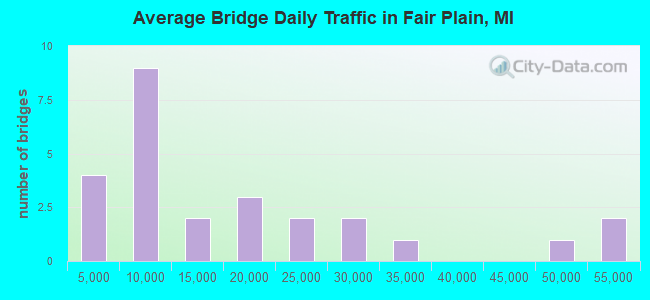
- 438,281Total average daily traffic
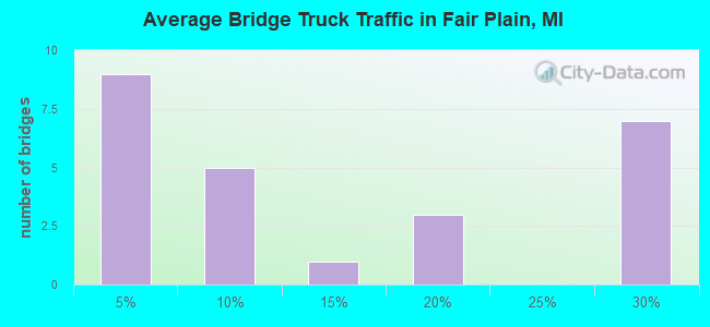
- 80,628Total average daily truck traffic
- National Bridge Inventory (NBI) Registered Bridges for Fair Plain
- No street view available for this location
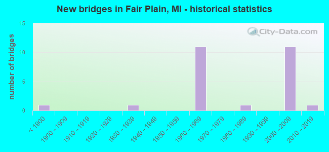
- New bridges - historical statistics
- 1Before 1900
- 11930-1939
- 111960-1969
- 11980-1989
- 112000-2009
- 12010-2019
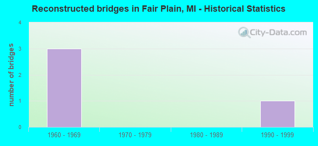
- Reconstructed bridges - Historical Statistics
- 31960-1969
- 01970-1979
- 01980-1989
- 11990-1999
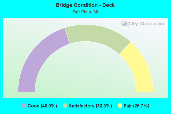
- Bridge Condition - Deck
- 40.0%Good
- 33.3%Satisfactory
- 26.7%Fair
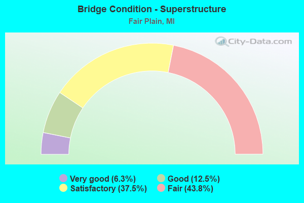
- Bridge Condition - Superstructure
- 6.3%Very good
- 12.5%Good
- 37.5%Satisfactory
- 43.8%Fair
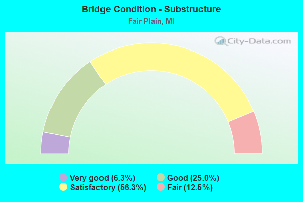
- Bridge Condition - Substructure
- 6.3%Very good
- 25.0%Good
- 56.3%Satisfactory
- 12.5%Fair
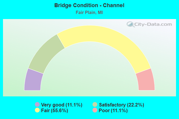
- Bridge Condition - Channel
- 11.1%Very good
- 22.2%Satisfactory
- 55.6%Fair
- 11.1%Poor
Find on map >> Show street view
Structure Number: 827, Location: 3.0 MI S OF BENTON HARBOR (Lat: 42.062272, Lng: -86.448244), Route carried "on" structure: Interstate 94, Year Built: 1960, Year Reconstructed: 1965, Status: Open, Structure Length: 19.63m (64.40ft), Average Daily Traffic: 34,063 (year 2014), Truck Traffic: 19%, Average Future Daily Traffic: 36,163 (year 2035), Design Load: HS 20, Features Intersected: ST JOSEPH RIVER
Minimum Vertical Clearance: 30.48m (100.00ft), Kilometerpoint: 44.294, Lanes on structure: 3, Base Highway Network: Yes (Inventory Route: 136, Subroute: 4), Owner: State Highway Agency, Approaching Roadway Width: 14.1m (46.3ft), Skew: 1 degrees, Navigation Control: Yes ( Vertical Clearance: 6.0m (19.7ft), Horizontal Clearance: 24.0m (78.7ft)), Material/Design: Steel, Design/Construction: Stringer/Multi-beam, Number Of Spans In Main Unit: 8, Length of Maximum Span: 25.6m (84.0ft), Curb-To-Curb Width: 14.3m (46.9ft), Out-to-Out Width: 15.2m (49.9ft)
Condition: Deck: Satisfactory, Superstructure: Fair, Substructure: Satisfactory, Channel: Fair, Operating Rating: 75.5 metric tons, Method Used To Determine Operating Rating: Load Factor (LF) rating reported by rating factor (RF) method using MS18 loading, Inventory Rating: 45.0 metric tons, Method Used To Determine Inventory Rating: Load Factor (LF) rating reported by rating factor (RF) method using MS18 loading, Structural Evaluation: Somewhat better than minimum adequacy, Deck Geometry: Meets minimum limits, Waterway Adequacy: Equal to present desirable criteria, Approach Roadway Alignment: Equal to present minimum criteria, Designated Inspection Frequency: Every 24 months, Underwater Inspection Frequency: Every 60 months, Inspection Date: July 2020, Underwater Inspection Date: June 2017, Deck Structure Type: Concrete Cast-file-Place, Wearing Surface/Protective System: Wearing Surface: Epoxy Overlay
Find on map >> Show street view
Structure Number: 832, Location: 2.9 MI S OF BENTON HARBOR (Lat: 42.068186, Lng: -86.436464), Route carried "on" structure: Interstate 94, Year Built: 2002, Status: Open, Structure Length: 6.98m (22.90ft), Average Daily Traffic: 26,303 (year 2007), Truck Traffic: 25%, Average Future Daily Traffic: 37,724 (year 2018), Design Load: HS 20+Mod, Features Intersected: M-139
Minimum Vertical Clearance: 30.48m (100.00ft), Kilometerpoint: 45.470, Lanes on structure: 4, Lanes under structure: 5, Base Highway Network: Yes (Inventory Route: 136, Subroute: 4), Owner: State Highway Agency, Approaching Roadway Width: 21.3m (69.9ft), Skew: 13 degrees, Material/Design: Prestressed concrete, Design/Construction: Box Beam or Girders - Multiple, Number Of Spans In Main Unit: 3, Length of Maximum Span: 30.4m (99.7ft), Curb-To-Curb Width: 22.2m (72.8ft), Out-to-Out Width: 23.0m (75.5ft)
Condition: Deck: Satisfactory, Superstructure: Fair, Substructure: Satisfactory, Operating Rating: 83.6 metric tons, Method Used To Determine Operating Rating: Load Factor (LF), Inventory Rating: 50.0 metric tons, Method Used To Determine Inventory Rating: Load Factor (LF), Structural Evaluation: Somewhat better than minimum adequacy, Deck Geometry: Superior to present desirable criteria, Underclear: Meets minimum limits, Approach Roadway Alignment: Better than present minimum criteria, Designated Inspection Frequency: Every 24 months, Inspection Date: October 2020, Deck Structure Type: Concrete Cast-file-Place, Wearing Surface/Protective System: Wearing Surface: Monolithic Concrete, Deck Protection: Epoxy Coated Reinforcing
Find on map >> Show street view
Structure Number: 833, Location: 2.9 MI S OF BENTON HARBOR (Lat: 42.068478, Lng: -86.436464), Route carried "on" structure: Interstate 94, Year Built: 2002, Status: Open, Structure Length: 6.98m (22.90ft), Average Daily Traffic: 26,303 (year 2007), Truck Traffic: 25%, Average Future Daily Traffic: 37,724 (year 2018), Design Load: HS 20+Mod, Features Intersected: M-139
Minimum Vertical Clearance: 30.48m (100.00ft), Kilometerpoint: 45.509, Lanes on structure: 4, Lanes under structure: 5, Base Highway Network: Yes (Inventory Route: 136, Subroute: 2), Owner: State Highway Agency, Approaching Roadway Width: 21.3m (69.9ft), Skew: 3 degrees, Material/Design: Prestressed concrete, Design/Construction: Box Beam or Girders - Multiple, Number Of Spans In Main Unit: 3, Length of Maximum Span: 30.4m (99.7ft), Curb-To-Curb Width: 22.3m (73.2ft), Out-to-Out Width: 23.0m (75.5ft)
Condition: Deck: Satisfactory, Superstructure: Fair, Substructure: Good, Operating Rating: 83.6 metric tons, Method Used To Determine Operating Rating: Load Factor (LF), Inventory Rating: 50.0 metric tons, Method Used To Determine Inventory Rating: Load Factor (LF), Structural Evaluation: Somewhat better than minimum adequacy, Deck Geometry: Superior to present desirable criteria, Underclear: Meets minimum limits, Approach Roadway Alignment: Better than present minimum criteria, Designated Inspection Frequency: Every 24 months, Inspection Date: October 2020, Deck Structure Type: Concrete Cast-file-Place, Wearing Surface/Protective System: Wearing Surface: Monolithic Concrete, Deck Protection: Epoxy Coated Reinforcing
Find on map >> Show street view
Structure Number: 834, Location: 1.6 MI S OF BENTON HARBOR (Lat: 42.071414, Lng: -86.430047), Route carried "on" structure: County highway 2013, Year Built: 1960, Status: Open, Structure Length: 8.06m (26.44ft), Average Daily Traffic: 5,381 (year 1984), Truck Traffic: 3%, Average Future Daily Traffic: 6,188 (year 2004), Design Load: H 20, Features Intersected: I-94, Facility Carried by Structure: NICKERSON AVE
Minimum Vertical Clearance: 30.48m (100.00ft), Kilometerpoint: 2.401, Lanes on structure: 2, Lanes under structure: 6, Owner: State Highway Agency, Approaching Roadway Width: 11.9m (39.0ft), Skew: 3 degrees, Material/Design: Concrete continuous, Design/Construction: Tee Beam, Number Of Spans In Main Unit: 4, Length of Maximum Span: 25.0m (82.0ft), Curb-To-Curb Width: 9.2m (30.2ft), Out-to-Out Width: 10.2m (33.5ft)
Condition: Deck: Satisfactory, Superstructure: Satisfactory, Substructure: Satisfactory, Operating Rating: 51.5 metric tons, Method Used To Determine Operating Rating: Load Factor (LF) rating reported by rating factor (RF) method using MS18 loading, Inventory Rating: 30.8 metric tons, Method Used To Determine Inventory Rating: Load Factor (LF) rating reported by rating factor (RF) method using MS18 loading, Structural Evaluation: Equal to present minimum criteria, Deck Geometry: Meets minimum limits, Underclear: Meets minimum limits, Approach Roadway Alignment: Equal to present minimum criteria, Designated Inspection Frequency: Every 24 months, Inspection Date: June 2020, Deck Structure Type: Concrete Cast-file-Place, Wearing Surface/Protective System: Wearing Surface: Latex Concrete
Find on map >> Show street view
Structure Number: 835, Location: 1.2 MI N OF M-139 (Lat: 42.078836, Lng: -86.417064), Route carried "on" structure: Interstate 94, Year Built: 1960, Year Reconstructed: 1965, Status: Open, Structure Length: 6.82m (22.38ft), Average Daily Traffic: 22,725 (year 2007), Truck Traffic: 28%, Average Future Daily Traffic: 33,991 (year 2018), Design Load: HS 20+Mod, Features Intersected: PIPESTONE ROAD
Minimum Vertical Clearance: 30.48m (100.00ft), Kilometerpoint: 47.471, Lanes on structure: 3, Lanes under structure: 4, Base Highway Network: Yes (Inventory Route: 136, Subroute: 4), Owner: State Highway Agency, Approaching Roadway Width: 15.0m (49.2ft), Skew: 5 degrees, Material/Design: Steel, Design/Construction: Stringer/Multi-beam, Number Of Spans In Main Unit: 3, Length of Maximum Span: 31.0m (101.7ft), Curb-To-Curb Width: 13.4m (44.0ft), Out-to-Out Width: 14.5m (47.6ft)
Condition: Deck: Fair, Superstructure: Fair, Substructure: Satisfactory, Operating Rating: 56.7 metric tons, Method Used To Determine Operating Rating: Load Factor (LF) rating reported by rating factor (RF) method using MS18 loading, Inventory Rating: 34.0 metric tons, Method Used To Determine Inventory Rating: Load Factor (LF) rating reported by rating factor (RF) method using MS18 loading, Structural Evaluation: Somewhat better than minimum adequacy, Deck Geometry: Meets minimum limits, Underclear: Meets minimum limits, Approach Roadway Alignment: Better than present minimum criteria, Designated Inspection Frequency: Every 24 months, Inspection Date: June 2020, Deck Structure Type: Concrete Cast-file-Place, Wearing Surface/Protective System: Wearing Surface: Latex Concrete
Find on map >> Show street view
Structure Number: 836, Location: 1.2 MI N OF M-139 (Lat: 42.079217, Lng: -86.417069), Route carried "on" structure: Interstate 94, Year Built: 1960, Year Reconstructed: 1965, Status: Open, Structure Length: 6.82m (22.38ft), Average Daily Traffic: 22,725 (year 2007), Truck Traffic: 28%, Average Future Daily Traffic: 33,991 (year 2018), Design Load: HS 20+Mod, Features Intersected: PIPESTONE ROAD
Minimum Vertical Clearance: 30.48m (100.00ft), Kilometerpoint: 47.516, Lanes on structure: 3, Lanes under structure: 4, Base Highway Network: Yes (Inventory Route: 136, Subroute: 2), Owner: State Highway Agency, Approaching Roadway Width: 15.0m (49.2ft), Skew: 15 degrees, Material/Design: Steel, Design/Construction: Stringer/Multi-beam, Number Of Spans In Main Unit: 3, Length of Maximum Span: 31.0m (101.7ft), Curb-To-Curb Width: 13.4m (44.0ft), Out-to-Out Width: 14.5m (47.6ft)
Condition: Deck: Fair, Superstructure: Fair, Substructure: Fair, Operating Rating: 67.7 metric tons, Method Used To Determine Operating Rating: Load Factor (LF) rating reported by rating factor (RF) method using MS18 loading, Inventory Rating: 40.5 metric tons, Method Used To Determine Inventory Rating: Load Factor (LF) rating reported by rating factor (RF) method using MS18 loading, Structural Evaluation: Somewhat better than minimum adequacy, Deck Geometry: Meets minimum limits, Underclear: Meets minimum limits, Approach Roadway Alignment: Better than present minimum criteria, Designated Inspection Frequency: Every 24 months, Inspection Date: June 2020, Bridge Improvement Cost: $249,000, Deck Structure Type: Concrete Cast-file-Place, Wearing Surface/Protective System: Wearing Surface: Latex Concrete
Find on map >> Show street view
Structure Number: 837, Location: 2.1 MI N OF M-139 (Lat: 42.090592, Lng: -86.409061), Route carried "on" structure: County highway 2013, Year Built: 2000, Status: Open, Structure Length: 6.38m (20.93ft), Average Daily Traffic: 16,549 (year 2007), Truck Traffic: 13%, Average Future Daily Traffic: 13,826 (year 2018), Design Load: HS 25 or greater, Features Intersected: I-94, Facility Carried by Structure: NAPIER ROAD
Minimum Vertical Clearance: 30.48m (100.00ft), Kilometerpoint: 6.478, Lanes on structure: 6, Lanes under structure: 6, Base Highway Network: Yes (Inventory Route: 136, Subroute: 2), Owner: State Highway Agency, Approaching Roadway Width: 20.2m (66.3ft), Skew: 2 degrees, Material/Design: Prestressed concrete, Design/Construction: Box Beam or Girders - Multiple, Number Of Spans In Main Unit: 2, Length of Maximum Span: 31.9m (104.7ft), Curb-To-Curb Width: 24.9m (81.7ft), Out-to-Out Width: 25.8m (84.6ft)
Condition: Deck: Satisfactory, Superstructure: Satisfactory, Substructure: Satisfactory, Operating Rating: 92.2 metric tons, Method Used To Determine Operating Rating: Load Factor (LF), Inventory Rating: 31.9 metric tons, Method Used To Determine Inventory Rating: Load Factor (LF), Structural Evaluation: Equal to present minimum criteria, Deck Geometry: Somewhat better than minimum adequacy, Underclear: High priority of corrective action, Approach Roadway Alignment: Equal to present desirable criteria, Designated Inspection Frequency: Every 24 months, Inspection Date: June 2020, Deck Structure Type: Concrete Cast-file-Place, Wearing Surface/Protective System: Wearing Surface: Monolithic Concrete, Deck Protection: Epoxy Coated Reinforcing
Find on map >> Show street view
Structure Number: 868, Location: 0.9 MI N OF SCOTTDALE (Lat: 42.053675, Lng: -86.436481), Route carried "on" structure: State highway 139, Year Built: 1899, Status: Open, Structure Length: 0.85m (2.79ft), Average Daily Traffic: 9,000 (year 2013), Truck Traffic: 3%, Average Future Daily Traffic: 11,402 (year 2018), Design Load: H 15, Features Intersected: BIG MEADOW DRAIN
Minimum Vertical Clearance: 30.48m (100.00ft), Kilometerpoint: 1.123, Lanes on structure: 2, Base Highway Network: Yes (Inventory Route: 136, Subroute: 8), Owner: State Highway Agency, Approaching Roadway Width: 13.4m (44.0ft), Material/Design: Concrete, Design/Construction: Arch - Deck, Number Of Spans In Main Unit: 1, Length of Maximum Span: 8.5m (27.9ft), Curb-To-Curb Width: 12.3m (40.4ft), Out-to-Out Width: 16.7m (54.8ft)
Condition: Superstructure: Satisfactory, Substructure: Satisfactory, Channel: Fair, Operating Rating: 87.5 metric tons, Method Used To Determine Operating Rating: Load Factor (LF) rating reported by rating factor (RF) method using MS18 loading, Inventory Rating: 52.5 metric tons, Method Used To Determine Inventory Rating: Load Factor (LF) rating reported by rating factor (RF) method using MS18 loading, Structural Evaluation: Equal to present minimum criteria, Deck Geometry: Somewhat better than minimum adequacy, Waterway Adequacy: Equal to present minimum criteria, Approach Roadway Alignment: Equal to present desirable criteria, Designated Inspection Frequency: Every 24 months, Inspection Date: April 2020, Bridge Improvement Cost: $48,000, Wearing Surface/Protective System: Wearing Surface: Bituminous
Find on map >> Show street view
Structure Number: 869, Location: 2.5 MI S OF BENTON HARBOR (Lat: 42.057606, Lng: -86.438336), Route carried "on" structure: State highway 139, Year Built: 1982, Status: Open, Structure Length: 12.37m (40.58ft), Average Daily Traffic: 9,250 (year 2007), Truck Traffic: 5%, Average Future Daily Traffic: 11,402 (year 2018), Design Load: HS 25 or greater, Features Intersected: ST JOSEPH RIVER
Minimum Vertical Clearance: 30.48m (100.00ft), Kilometerpoint: 1.696, Lanes on structure: 2, Base Highway Network: Yes (Inventory Route: 136, Subroute: 8), Owner: State Highway Agency, Approaching Roadway Width: 14.8m (48.6ft), Navigation Control: Yes ( Vertical Clearance: 5.7m (18.7ft), Horizontal Clearance: 25.1m (82.3ft)), Material/Design: Prestressed concrete, Design/Construction: Box Beam or Girders - Multiple, Number Of Spans In Main Unit: 5, Length of Maximum Span: 25.9m (85.0ft), Curb-To-Curb Width: 17.2m (56.4ft), Out-to-Out Width: 18.1m (59.4ft)
Condition: Deck: Fair, Superstructure: Fair, Substructure: Fair, Channel: Satisfactory, Operating Rating: 71.3 metric tons, Method Used To Determine Operating Rating: Load Factor (LF) rating reported by rating factor (RF) method using MS18 loading, Inventory Rating: 42.8 metric tons, Method Used To Determine Inventory Rating: Load Factor (LF) rating reported by rating factor (RF) method using MS18 loading, Structural Evaluation: Somewhat better than minimum adequacy, Deck Geometry: Superior to present desirable criteria, Waterway Adequacy: Equal to present desirable criteria, Approach Roadway Alignment: Equal to present desirable criteria, Designated Inspection Frequency: Every 24 months, Underwater Inspection Frequency: Every 60 months, Inspection Date: July 2020, Underwater Inspection Date: June 2017, Deck Structure Type: Concrete Cast-file-Place, Wearing Surface/Protective System: Wearing Surface: Epoxy Overlay, Deck Protection: Epoxy Coated Reinforcing
Find on map >> Show street view
Structure Number: 871, Location: SE LTS OF BENTON HARBOR (Lat: 42.099461, Lng: -86.434469), Route carried "on" structure: State highway 139, Year Built: 1936, Year Reconstructed: 1990, Status: Open, Structure Length: 20.48m (67.19ft), Average Daily Traffic: 10,503 (year 2007), Truck Traffic: 9%, Average Future Daily Traffic: 12,087 (year 2018), Design Load: HS 20, Features Intersected: CONRAIL (ABN) & OX CREEK
Minimum Vertical Clearance: 30+ m (98+ ft), Kilometerpoint: 6.317, Lanes on structure: 4, Base Highway Network: Yes (Inventory Route: 136, Subroute: 8), Owner: State Highway Agency, Approaching Roadway Width: 15.8m (51.8ft), Material/Design: Steel, Design/Construction: Stringer/Multi-beam, Number Of Spans In Main Unit: 9, Length of Maximum Span: 26.5m (86.9ft), Curb or Sidewalk Widths: Left: 0.0m, Right: 1.6m (5.2ft), Curb-To-Curb Width: 15.8m (51.8ft), Out-to-Out Width: 18.5m (60.7ft)
Condition: Deck: Good, Superstructure: Satisfactory, Substructure: Satisfactory, Channel: Satisfactory, Operating Rating: 58.0 metric tons, Method Used To Determine Operating Rating: Load Factor (LF) rating reported by rating factor (RF) method using MS18 loading, Inventory Rating: 34.7 metric tons, Method Used To Determine Inventory Rating: Load Factor (LF) rating reported by rating factor (RF) method using MS18 loading, Structural Evaluation: Equal to present minimum criteria, Deck Geometry: Meets minimum limits, Waterway Adequacy: Equal to present desirable criteria, Approach Roadway Alignment: Equal to present desirable criteria, Designated Inspection Frequency: Every 24 months, Inspection Date: June 2020, Deck Structure Type: Concrete Cast-file-Place, Wearing Surface/Protective System: Wearing Surface: Monolithic Concrete, Deck Protection: Epoxy Coated Reinforcing
Find on map >> Show street view
Structure Number: 975, Location: E CITY LIMIT ST JOSEPH (Lat: 42.088489, Lng: -86.474317), Route carried "on" structure: County highway 2013, Year Built: 1966, Status: Open, Structure Length: 18.29m (60.01ft), Average Daily Traffic: 16,463 (year 2007), Truck Traffic: 4%, Average Future Daily Traffic: 25,000 (year 2027), Design Load: HS 20, Features Intersected: ST JOSEPH RIVER, Facility Carried by Structure: NAPIER AVENUE
Minimum Vertical Clearance: 30.48m (100.00ft), Kilometerpoint: 0.827, Lanes on structure: 4, Owner: County Highway Agency, Approaching Roadway Width: 18.9m (62.0ft), Skew: 20 degrees, Navigation Control: Yes ( Vertical Clearance: 0.3m (1.0ft), Horizontal Clearance: 20.0m (65.6ft)), Material/Design: Steel continuous, Design/Construction: Stringer/Multi-beam, Number Of Spans In Main Unit: 4, Length of Maximum Span: 51.5m (169.0ft), Curb or Sidewalk Widths: Left: 1.5m (4.9ft), Right: 1.5m (4.9ft), Curb-To-Curb Width: 15.9m (52.2ft), Out-to-Out Width: 19.6m (64.3ft)
Condition: Deck: Fair, Superstructure: Fair, Substructure: Satisfactory, Channel: Poor, Operating Rating: 65.8 metric tons, Method Used To Determine Operating Rating: Load Factor (LF) rating reported by rating factor (RF) method using MS18 loading, Inventory Rating: 39.5 metric tons, Method Used To Determine Inventory Rating: Load Factor (LF) rating reported by rating factor (RF) method using MS18 loading, Structural Evaluation: Somewhat better than minimum adequacy, Deck Geometry: Meets minimum limits, Waterway Adequacy: Superior to present desirable criteria, Approach Roadway Alignment: Equal to present desirable criteria, Length Of Structure Improvement: 18.30m (60.04ft), Designated Inspection Frequency: Every 24 months, Underwater Inspection Frequency: Every 60 months, Inspection Date: July 2020, Underwater Inspection Date: June 2018, Bridge Improvement Cost: $3,080,000, Roadway Improvement Cost: $496,000, Total Project Cost: $3,576,000 ( Estimate for 2016), Deck Structure Type: Concrete Cast-file-Place, Wearing Surface/Protective System: Wearing Surface: Latex Concrete
Find on map >> Show street view
Structure Number: 992, Location: 3 MI NE OF SODUS (Lat: 42.060842, Lng: -86.401603), Route carried "on" structure: County highway , Year Built: 2017, Status: Open, Structure Length: 1.58m (5.18ft), Average Daily Traffic: 1,335 (year 2017), Truck Traffic: 6%, Average Future Daily Traffic: 1,984 (year 2037), Design Load: Greater than HL93, Features Intersected: PIPESTONE CREEK, Facility Carried by Structure: RIVER ROAD
Minimum Vertical Clearance: 30.48m (100.00ft), Kilometerpoint: 7.513, Lanes on structure: 2, Owner: County Highway Agency, Approaching Roadway Width: 9.6m (31.5ft), Material/Design: Prestressed concrete, Design/Construction: Box Beam or Girders - Multiple, Number Of Spans In Main Unit: 1, Length of Maximum Span: 15.5m (50.9ft), Curb-To-Curb Width: 9.8m (32.2ft), Out-to-Out Width: 10.6m (34.8ft)
Condition: Deck: Good, Superstructure: Very good, Substructure: Very good, Channel: Very good, Operating Rating: 68.4 metric tons, Method Used To Determine Operating Rating: Load and Resistance Factor Rating (LRFR) rating reported by rating factor(RF) method using HL-93 loadings, Inventory Rating: 52.8 metric tons, Method Used To Determine Inventory Rating: Load and Resistance Factor Rating (LRFR) rating reported by rating factor(RF) method using HL-93 loadings, Structural Evaluation: Equal to present desirable criteria, Deck Geometry: Somewhat better than minimum adequacy, Waterway Adequacy: Equal to present desirable criteria, Approach Roadway Alignment: Equal to present desirable criteria, Designated Inspection Frequency: Every 24 months, Inspection Date: June 2020, Deck Structure Type: Concrete Cast-file-Place, Wearing Surface/Protective System: Wearing Surface: Monolithic Concrete, Deck Protection: Epoxy Coated Reinforcing
Find on map >> Show street view
Structure Number: 12895, Location: 7.2 MI N OF OLD US-31 (Lat: 42.064275, Lng: -86.372964), Route carried "on" structure: US 31, Year Built: 2000, Status: Open, Structure Length: 19.96m (65.49ft), Average Daily Traffic: 3,701 (year 2007), Truck Traffic: 3%, Average Future Daily Traffic: 12,300 (year 2010), Design Load: HS 25 or greater, Features Intersected: PIPESTONE CREEK
Minimum Vertical Clearance: 30.48m (100.00ft), Kilometerpoint: 36.469, Lanes on structure: 2, Base Highway Network: Yes (Inventory Route: 177, Subroute: 5), Owner: State Highway Agency, Approaching Roadway Width: 12.4m (40.7ft), Material/Design: Prestressed concrete, Design/Construction: Stringer/Multi-beam, Number Of Spans In Main Unit: 6, Length of Maximum Span: 35.0m (114.8ft), Curb-To-Curb Width: 13.4m (44.0ft), Out-to-Out Width: 14.4m (47.2ft)
Condition: Deck: Good, Superstructure: Satisfactory, Substructure: Good, Channel: Fair, Operating Rating: 52.5 metric tons, Method Used To Determine Operating Rating: Load and Resistance Factor Rating (LRFR) rating reported by rating factor(RF) method using HL-93 loadings, Inventory Rating: 39.9 metric tons, Method Used To Determine Inventory Rating: Load and Resistance Factor Rating (LRFR) rating reported by rating factor(RF) method using HL-93 loadings, Structural Evaluation: Equal to present minimum criteria, Deck Geometry: Superior to present desirable criteria, Waterway Adequacy: Equal to present desirable criteria, Approach Roadway Alignment: Equal to present desirable criteria, Designated Inspection Frequency: Every 24 months, Inspection Date: July 2020, Deck Structure Type: Concrete Cast-file-Place, Wearing Surface/Protective System: Wearing Surface: Monolithic Concrete, Deck Protection: Epoxy Coated Reinforcing
Find on map >> Show street view
Structure Number: 12896, Location: 7.2 MI N OF OLD US-31 (Lat: 42.064253, Lng: -86.372681), Route carried "on" structure: US 31, Year Built: 2002, Status: Open, Structure Length: 18.44m (60.50ft), Average Daily Traffic: 3,701 (year 2007), Truck Traffic: 19%, Average Future Daily Traffic: 4,693 (year 2018), Design Load: HS 25 or greater, Features Intersected: PIPESTONE CREEK
Minimum Vertical Clearance: 30.48m (100.00ft), Kilometerpoint: 36.508, Lanes on structure: 2, Base Highway Network: Yes (Inventory Route: 177, Subroute: 3), Owner: State Highway Agency, Approaching Roadway Width: 12.4m (40.7ft), Material/Design: Prestressed concrete, Design/Construction: Stringer/Multi-beam, Number Of Spans In Main Unit: 6, Length of Maximum Span: 35.0m (114.8ft), Curb-To-Curb Width: 13.4m (44.0ft), Out-to-Out Width: 14.4m (47.2ft)
Condition: Deck: Good, Superstructure: Satisfactory, Substructure: Satisfactory, Channel: Fair, Operating Rating: 66.1 metric tons, Method Used To Determine Operating Rating: Load Factor (LF) rating reported by rating factor (RF) method using MS18 loading, Inventory Rating: 32.7 metric tons, Method Used To Determine Inventory Rating: Load Factor (LF) rating reported by rating factor (RF) method using MS18 loading, Structural Evaluation: Equal to present minimum criteria, Deck Geometry: Superior to present desirable criteria, Waterway Adequacy: Equal to present desirable criteria, Approach Roadway Alignment: Equal to present desirable criteria, Designated Inspection Frequency: Every 24 months, Inspection Date: July 2020, Deck Structure Type: Concrete Cast-file-Place, Wearing Surface/Protective System: Wearing Surface: Monolithic Concrete, Deck Protection: Epoxy Coated Reinforcing
Find on map >> Show street view
Structure Number: 12897, Location: 6.4 MI N OF OLD US-31 (Lat: 42.053867, Lng: -86.376278), Route carried "on" structure: County highway , Year Built: 2001, Status: Open, Structure Length: 9.72m (31.89ft), Average Daily Traffic: 8,380 (year 2003), Truck Traffic: 19%, Average Future Daily Traffic: 9,386 (year 2018), Design Load: HS 20, Features Intersected: US-31, Facility Carried by Structure: PIPESTONE ROAD
Minimum Vertical Clearance: 30.48m (100.00ft), Kilometerpoint: 3.975, Lanes on structure: 5, Lanes under structure: 4, Owner: State Highway Agency, Approaching Roadway Width: 23.1m (75.8ft), Material/Design: Prestressed concrete, Design/Construction: Stringer/Multi-beam, Number Of Spans In Main Unit: 4, Length of Maximum Span: 36.6m (120.1ft), Curb-To-Curb Width: 24.5m (80.4ft), Out-to-Out Width: 25.4m (83.3ft)
Condition: Deck: Good, Superstructure: Good, Substructure: Good, Operating Rating: 67.7 metric tons, Method Used To Determine Operating Rating: Load Factor (LF) rating reported by rating factor (RF) method using MS18 loading, Inventory Rating: 31.1 metric tons, Method Used To Determine Inventory Rating: Load Factor (LF) rating reported by rating factor (RF) method using MS18 loading, Structural Evaluation: Better than present minimum criteria, Deck Geometry: Superior to present desirable criteria, Underclear: Equal to present minimum criteria, Approach Roadway Alignment: Equal to present desirable criteria, Designated Inspection Frequency: Every 24 months, Inspection Date: August 2020, Deck Structure Type: Concrete Cast-file-Place, Wearing Surface/Protective System: Wearing Surface: Monolithic Concrete, Deck Protection: Epoxy Coated Reinforcing
Find on map >> Show street view
Structure Number: 13193, Location: SODUS TWP SEC 3 (Lat: 42.059939, Lng: -86.389867), Route carried "on" structure: County highway , Year Built: 2002, Status: Open, Structure Length: 13.94m (45.73ft), Average Daily Traffic: 8,632 (year 2007), Truck Traffic: 4%, Average Future Daily Traffic: 10,000 (year 2027), Design Load: HS 20, Features Intersected: PIPESTONE CREEK, Facility Carried by Structure: SODUS PARKWAY
Minimum Vertical Clearance: 30.48m (100.00ft), Kilometerpoint: 2.656, Lanes on structure: 4, Base Highway Network: Yes (Inventory Route: 311, Subroute: 52), Owner: County Highway Agency, Approaching Roadway Width: 20.7m (67.9ft), Skew: 3 degrees, Material/Design: Prestressed concrete, Design/Construction: Stringer/Multi-beam, Number Of Spans In Main Unit: 6, Length of Maximum Span: 22.7m (74.5ft), Curb-To-Curb Width: 20.7m (67.9ft), Out-to-Out Width: 21.7m (71.2ft)
Condition: Deck: Good, Superstructure: Good, Substructure: Good, Channel: Fair, Operating Rating: 79.7 metric tons, Method Used To Determine Operating Rating: Load Factor (LF) rating reported by rating factor (RF) method using MS18 loading, Inventory Rating: 47.6 metric tons, Method Used To Determine Inventory Rating: Load Factor (LF) rating reported by rating factor (RF) method using MS18 loading, Structural Evaluation: Better than present minimum criteria, Deck Geometry: Superior to present desirable criteria, Waterway Adequacy: Superior to present desirable criteria, Approach Roadway Alignment: Equal to present desirable criteria, Designated Inspection Frequency: Every 24 months, Inspection Date: June 2020, Deck Structure Type: Concrete Cast-file-Place, Wearing Surface/Protective System: Wearing Surface: Monolithic Concrete, Deck Protection: Epoxy Coated Reinforcing
Find on map >> Show street view
Structure Number: 823, Location: 2.2 MI S OF ST JOSEPH (Lat: 42.054800, Lng: -86.475283), Route carried "under" structure: County highway 2013, Year Built: 1960, Structure Length: 0. m, Average Daily Traffic: 6,030 (year 1992), Truck Traffic: 2%, Features Intersected: LINCOLN AVE, Facility Carried by Structure: I-94 EB
Minimum Vertical Clearance: 4.62m (15.16ft), Kilometerpoint: 9.534, Lanes on structure: 3, Lanes under structure: 2, Material/Design: Concrete continuous, Design/Construction: Tee Beam, Length of Maximum Span: 14.0m (45.9ft)
Find on map >> Show street view
Structure Number: 824, Location: 2.2 MI S OF ST JOSEPH (Lat: 42.055053, Lng: -86.475281), Route carried "under" structure: County highway 2013, Year Built: 1960, Structure Length: 0. m, Average Daily Traffic: 6,030 (year 1992), Truck Traffic: 3%, Features Intersected: LINCOLN AVE, Facility Carried by Structure: I-94 WB
Minimum Vertical Clearance: 4.57m (14.99ft), Kilometerpoint: 9.563, Lanes on structure: 3, Lanes under structure: 2, Material/Design: Concrete continuous, Design/Construction: Tee Beam, Length of Maximum Span: 14.0m (45.9ft)
Find on map >> Show street view
Structure Number: 825, Location: 3.2 MI S OF BENTON HARBOR (Lat: 42.058533, Lng: -86.457939), Route carried "under" structure: Interstate 94, Year Built: 1960, Structure Length: 0. m, Average Daily Traffic: 52,606 (year 2007), Truck Traffic: 25%, Features Intersected: I-94, Facility Carried by Structure: M-63
Minimum Vertical Clearance: 6.10m (20.01ft), Kilometerpoint: 43.385, Lanes on structure: 2, Lanes under structure: 8, Material/Design: Concrete continuous, Design/Construction: Tee Beam, Length of Maximum Span: 28.3m (92.8ft)
Find on map >> Show street view
Structure Number: 832, Location: 2.9 MI S OF BENTON HARBOR (Lat: 42.068186, Lng: -86.436464), Route carried "under" structure: State highway 139, Year Built: 2002, Structure Length: 0. m, Average Daily Traffic: 9,250 (year 2007), Truck Traffic: 5%, Features Intersected: M-139, Facility Carried by Structure: I-94 EB
Minimum Vertical Clearance: 5.89m (19.32ft), Kilometerpoint: 2.831, Lanes on structure: 4, Lanes under structure: 5, Material/Design: Prestressed concrete, Design/Construction: Box Beam or Girders - Multiple, Length of Maximum Span: 30.4m (99.7ft)
Find on map >> Show street view
Structure Number: 833, Location: 2.9 MI S OF BENTON HARBOR (Lat: 42.068478, Lng: -86.436464), Route carried "under" structure: State highway 139, Year Built: 2002, Structure Length: 0. m, Average Daily Traffic: 9,250 (year 2007), Truck Traffic: 5%, Features Intersected: M-139, Facility Carried by Structure: I-94 WB
Minimum Vertical Clearance: 4.70m (15.42ft), Kilometerpoint: 2.863, Lanes on structure: 4, Lanes under structure: 5, Material/Design: Prestressed concrete, Design/Construction: Box Beam or Girders - Multiple, Length of Maximum Span: 30.4m (99.7ft)
Find on map >> Show street view
Structure Number: 834, Location: 1.6 MI S OF BENTON HARBOR (Lat: 42.071414, Lng: -86.430047), Route carried "under" structure: Interstate 94, Year Built: 1960, Structure Length: 0. m, Average Daily Traffic: 45,450 (year 2007), Truck Traffic: 25%, Features Intersected: I-94, Facility Carried by Structure: NICKERSON AVE
Minimum Vertical Clearance: 5.48m (17.98ft), Kilometerpoint: 46.111, Lanes on structure: 2, Lanes under structure: 6, Material/Design: Concrete continuous, Design/Construction: Tee Beam, Length of Maximum Span: 25.0m (82.0ft)
Find on map >> Show street view
Structure Number: 835, Location: 1.2 MI N OF M-139 (Lat: 42.078836, Lng: -86.417064), Route carried "under" structure: County highway 2013, Year Built: 1960, Structure Length: 0. m, Average Daily Traffic: 4,700 (year 0000), Features Intersected: PIPESTONE ROAD, Facility Carried by Structure: I-94 EB
Minimum Vertical Clearance: 4.65m (15.26ft), Kilometerpoint: 5.330, Lanes on structure: 3, Lanes under structure: 4, Material/Design: Steel, Design/Construction: Stringer/Multi-beam, Length of Maximum Span: 31.0m (101.7ft)
Find on map >> Show street view
Structure Number: 836, Location: 1.2 MI N OF M-139 (Lat: 42.079217, Lng: -86.417069), Route carried "under" structure: County highway 2013, Year Built: 1960, Structure Length: 0. m, Average Daily Traffic: 19,177 (year 1990), Truck Traffic: 3%, Features Intersected: PIPESTONE ROAD, Facility Carried by Structure: I-94 WB
Minimum Vertical Clearance: 4.82m (15.81ft), Kilometerpoint: 5.288, Lanes on structure: 3, Lanes under structure: 4, Material/Design: Steel, Design/Construction: Stringer/Multi-beam, Length of Maximum Span: 31.0m (101.7ft)
Find on map >> Show street view
Structure Number: 837, Location: 2.1 MI N OF M-139 (Lat: 42.090592, Lng: -86.409061), Route carried "under" structure: Interstate 94, Year Built: 2000, Structure Length: 0. m, Average Daily Traffic: 50,672 (year 2007), Truck Traffic: 28%, Features Intersected: I-94, Facility Carried by Structure: NAPIER ROAD
Minimum Vertical Clearance: 4.93m (16.17ft), Kilometerpoint: 48.939, Lanes on structure: 6, Lanes under structure: 6, Material/Design: Prestressed concrete, Design/Construction: Box Beam or Girders - Multiple, Length of Maximum Span: 31.9m (104.7ft)
Find on map >> Show street view
Structure Number: 12897, Location: 6.4 MI N OF OLD US-31 (Lat: 42.053867, Lng: -86.376278), Route carried "under" structure: US 31, Year Built: 2001, Structure Length: 0. m, Average Daily Traffic: 10,102 (year 2007), Truck Traffic: 3%, Features Intersected: US-31, Facility Carried by Structure: PIPESTONE ROAD
Minimum Vertical Clearance: 5.31m (17.42ft), Kilometerpoint: 35.307, Lanes on structure: 5, Lanes under structure: 4, Material/Design: Prestressed concrete, Design/Construction: Stringer/Multi-beam, Length of Maximum Span: 36.6m (120.1ft)