Bridge Statistics for Fairfax Station, Virginia (VA)
Condition, Traffic, Stress, Structural Evaluation, Project Costs
- National Bridge Inventory (NBI) Statistics
- 30Number of bridges
- 203ft / 61.5mTotal length
- $3,205,000Total costs
- 410,928Total average daily traffic
- 8,500Total average daily truck traffic
- National Bridge Inventory (NBI) Registered Bridges for Fairfax Station
- No street view available for this location
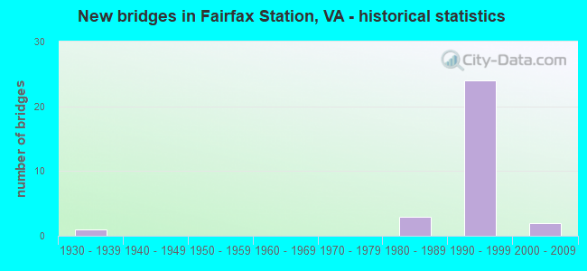
- New bridges - historical statistics
- 11930-1939
- 31980-1989
- 241990-1999
- 22000-2009
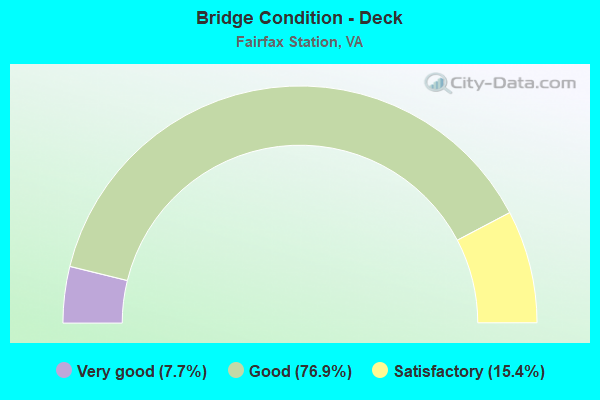
- Bridge Condition - Deck
- 7.7%Very good
- 76.9%Good
- 15.4%Satisfactory
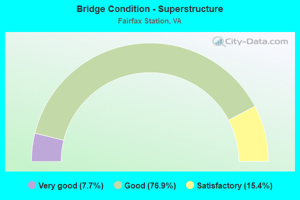
- Bridge Condition - Superstructure
- 7.7%Very good
- 76.9%Good
- 15.4%Satisfactory
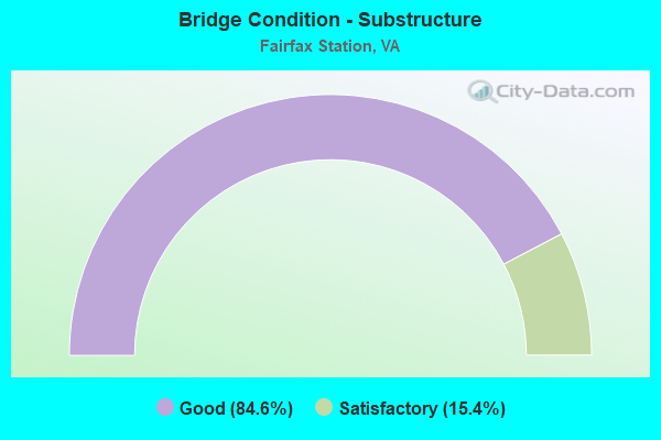
- Bridge Condition - Substructure
- 84.6%Good
- 15.4%Satisfactory
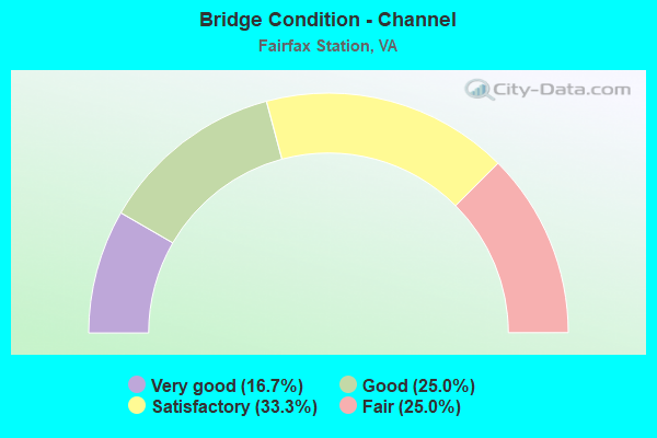
- Bridge Condition - Channel
- 16.7%Very good
- 25.0%Good
- 33.3%Satisfactory
- 25.0%Fair
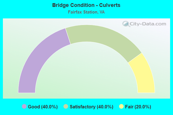
- Bridge Condition - Culverts
- 40.0%Good
- 40.0%Satisfactory
- 20.0%Fair
Find on map >> Show street view
Structure Number: 6767, Location: 0.55FR123 1.20TO610 (Lat: 38.764028, Lng: -77.322431), Route carried "on" structure: County highway 645, Year Built: 1986, Status: Open, Structure Length: 0.91m (2.99ft), Average Daily Traffic: 4,024 (year 2020), Average Future Daily Traffic: 5,240 (year 2040), Design Load: HS 20, Features Intersected: SANDY RUN, Facility Carried by Structure: CLIFTON RD.
Minimum Vertical Clearance: 30+ m (98+ ft), Kilometerpoint: 24.859, Lanes on structure: 2, Owner: State Highway Agency, Approaching Roadway Width: 7.9m (25.9ft), Material/Design: Steel, Design/Construction: Culvert, Number Of Spans In Main Unit: 3, Length of Maximum Span: 2.4m (7.9ft)
Condition: Channel: Good, Culverts: Fair, Operating Rating: 44.5 metric tons, Method Used To Determine Operating Rating: Load Factor (LF), Inventory Rating: 32.7 metric tons, Method Used To Determine Inventory Rating: Load Factor (LF), Structural Evaluation: Somewhat better than minimum adequacy, Waterway Adequacy: Equal to present minimum criteria, Approach Roadway Alignment: Equal to present minimum criteria, Length Of Structure Improvement: 2.74m (8.99ft), Designated Inspection Frequency: Every 24 months, Inspection Date: December 2021, Bridge Improvement Cost: $50,000, Roadway Improvement Cost: $100,000, Total Project Cost: $160,000
Find on map >> Show street view
Structure Number: 6792, Location: 00.65FR.5439/00.35TO5436 (Lat: 38.816144, Lng: -77.337531), Route carried "on" structure: County highway 654, Year Built: 1930, Status: Open, Structure Length: 0.82m (2.69ft), Average Daily Traffic: 2,828 (year 2020), Truck Traffic: 3%, Average Future Daily Traffic: 3,959 (year 2040), Design Load: HS 20, Features Intersected: POPES HEAD CREEK, Facility Carried by Structure: POPES HEAD ROAD
Minimum Vertical Clearance: 30+ m (98+ ft), Kilometerpoint: 6.018, Lanes on structure: 2, Owner: State Highway Agency, Approaching Roadway Width: 9.1m (29.9ft), Material/Design: Prestressed concrete, Design/Construction: Slab, Number Of Spans In Main Unit: 1, Length of Maximum Span: 8.2m (26.9ft), Curb-To-Curb Width: 7.2m (23.6ft), Out-to-Out Width: 8.5m (27.9ft)
Condition: Deck: Good, Superstructure: Good, Substructure: Satisfactory, Channel: Fair, Operating Rating: 89.8 metric tons, Method Used To Determine Operating Rating: Load and Resistance Factor (LRFR), Inventory Rating: 70.6 metric tons, Method Used To Determine Inventory Rating: Load and Resistance Factor (LRFR), Structural Evaluation: Equal to present minimum criteria, Deck Geometry: High priority of replacement, Waterway Adequacy: Somewhat better than minimum adequacy, Approach Roadway Alignment: Equal to present minimum criteria, Length Of Structure Improvement: 0.91m (2.99ft), Designated Inspection Frequency: Every 24 months, Inspection Date: September 2020, Bridge Improvement Cost: $162,000, Roadway Improvement Cost: $16,000, Total Project Cost: $188,000 ( Estimate for 2014), Deck Structure Type: Concrete Precast Panels, Wearing Surface/Protective System: Wearing Surface: Bituminous, Membrane: Epoxy, Deck Protection: Epoxy Coated Reinforcing
Find on map >> Show street view
Structure Number: 6793, Location: 01.30FR.5435/00.60TO612 (Lat: 38.814886, Lng: -77.365725), Route carried "on" structure: County highway 654, Year Built: 1984, Year Reconstructed: 2018, Status: Open, Structure Length: 1.52m (4.99ft), Average Daily Traffic: 1,370 (year 2020), Truck Traffic: 3%, Average Future Daily Traffic: 1,551 (year 2040), Design Load: HS 20, Features Intersected: PINEY BRANCH, Facility Carried by Structure: POPES HEAD ROAD
Minimum Vertical Clearance: 30+ m (98+ ft), Kilometerpoint: 3.089, Lanes on structure: 2, Owner: State Highway Agency, Approaching Roadway Width: 7.3m (24.0ft), Skew: 4 degrees, Material/Design: Prestressed concrete, Design/Construction: Slab, Number Of Spans In Main Unit: 1, Length of Maximum Span: 13.9m (45.6ft), Curb or Sidewalk Widths: Left: 0.2m (0.7ft), Right: 0.2m (0.7ft), Curb-To-Curb Width: 7.5m (24.6ft), Out-to-Out Width: 8.5m (27.9ft)
Condition: Deck: Very good, Superstructure: Very good, Substructure: Good, Channel: Satisfactory, Operating Rating: 36.1 metric tons, Method Used To Determine Operating Rating: Load Factor (LF), Inventory Rating: 22.1 metric tons, Method Used To Determine Inventory Rating: Load Factor (LF), Structural Evaluation: Somewhat better than minimum adequacy, Deck Geometry: Meets minimum limits, Waterway Adequacy: Equal to present minimum criteria, Approach Roadway Alignment: Equal to present minimum criteria, Length Of Structure Improvement: 1.52m (4.99ft), Designated Inspection Frequency: Every 24 months, Inspection Date: December 2020, Bridge Improvement Cost: $270,000, Roadway Improvement Cost: $30,000, Total Project Cost: $310,000 ( Estimate for 2014), Deck Structure Type: Concrete Precast Panels, Wearing Surface/Protective System: Wearing Surface: Bituminous, Membrane: Preformed Fabric
Find on map >> Show street view
Structure Number: 6811, Location: .35 TO 4538 & .08 TO 6048 (Lat: 38.798106, Lng: -77.351800), Route carried "on" structure: County highway 660, Year Built: 1995, Status: Open, Structure Length: 0.88m (2.89ft), Average Daily Traffic: 1,852 (year 2020), Truck Traffic: 2%, Average Future Daily Traffic: 2,593 (year 2040), Design Load: HS 20, Features Intersected: POPES HEAD CREEK, Facility Carried by Structure: FAIRFAX STATION RD
Minimum Vertical Clearance: 30+ m (98+ ft), Kilometerpoint: 2.928, Lanes on structure: 2, Owner: State Highway Agency, Approaching Roadway Width: 7.6m (24.9ft), Skew: 1 degrees, Material/Design: Concrete, Design/Construction: Slab, Number Of Spans In Main Unit: 1, Length of Maximum Span: 8.8m (28.9ft), Curb-To-Curb Width: 6.6m (21.7ft), Out-to-Out Width: 7.3m (24.0ft)
Condition: Deck: Satisfactory, Superstructure: Satisfactory, Substructure: Satisfactory, Channel: Satisfactory, Operating Rating: 61.0 metric tons, Method Used To Determine Operating Rating: Load and Resistance Factor (LRFR), Inventory Rating: 44.6 metric tons, Method Used To Determine Inventory Rating: Load and Resistance Factor (LRFR), Structural Evaluation: Equal to present minimum criteria, Deck Geometry: High priority of replacement, Waterway Adequacy: Equal to present minimum criteria, Approach Roadway Alignment: Equal to present minimum criteria, Length Of Structure Improvement: 0.85m (2.79ft), Designated Inspection Frequency: Every 24 months, Inspection Date: July 2021, Bridge Improvement Cost: $550,000, Roadway Improvement Cost: $55,000, Total Project Cost: $610,000 ( Estimate for 2015), Deck Structure Type: Concrete Precast Panels, Wearing Surface/Protective System: Wearing Surface: Bituminous
Find on map >> Show street view
Structure Number: 7102, Location: 0.05FR8166 0.10TO D.END (Lat: 38.780028, Lng: -77.318414), Route carried "on" structure: County highway 8168, Year Built: 1989, Status: Open, Structure Length: 0.98m (3.22ft), Average Daily Traffic: 95 (year 2014), Average Future Daily Traffic: 107 (year 2040), Design Load: HS 20+Mod, Features Intersected: TRIB.OF BURKE LAKE, Facility Carried by Structure: BARSKY COURT
Minimum Vertical Clearance: 30+ m (98+ ft), Kilometerpoint: 0.354, Lanes on structure: 2, Owner: State Highway Agency, Approaching Roadway Width: 6.4m (21.0ft), Material/Design: Concrete, Design/Construction: Culvert, Number Of Spans In Main Unit: 4, Length of Maximum Span: 1.5m (4.9ft)
Condition: Channel: Fair, Culverts: Good, Operating Rating: 44.5 metric tons, Method Used To Determine Operating Rating: Load Factor (LF), Inventory Rating: 32.7 metric tons, Method Used To Determine Inventory Rating: Load Factor (LF), Structural Evaluation: Better than present minimum criteria, Waterway Adequacy: Better than present minimum criteria, Approach Roadway Alignment: Equal to present desirable criteria, Designated Inspection Frequency: Every 24 months, Inspection Date: Febuary 2021
Find on map >> Show street view
Structure Number: 23858, Location: 00.10FR6506/00.10TO6504 (Lat: 38.792917, Lng: -77.334592), Route carried "on" structure: County highway 6500, Year Built: 1993, Status: Open, Structure Length: 5.82m (19.09ft), Average Daily Traffic: 2,325 (year 2019), Average Future Daily Traffic: 2,569 (year 2040), Design Load: HS 20, Features Intersected: FAIRFAX COUNTY PKWY., Facility Carried by Structure: CLARA BARTON DR.
Minimum Vertical Clearance: 30+ m (98+ ft), Kilometerpoint: 0.000, Lanes on structure: 2, Lanes under structure: 4, Owner: State Highway Agency, Approaching Roadway Width: 8.8m (28.9ft), Material/Design: Prestressed concrete, Design/Construction: Stringer/Multi-beam, Number Of Spans In Main Unit: 2, Length of Maximum Span: 28.7m (94.2ft), Curb or Sidewalk Widths: Left: 0.0m, Right: 2.0m (6.6ft), Curb-To-Curb Width: 8.2m (26.9ft), Out-to-Out Width: 11.9m (39.0ft)
Condition: Deck: Good, Superstructure: Satisfactory, Substructure: Good, Operating Rating: 79.7 metric tons, Method Used To Determine Operating Rating: Load and Resistance Factor (LRFR), Inventory Rating: 61.5 metric tons, Method Used To Determine Inventory Rating: Load and Resistance Factor (LRFR), Structural Evaluation: Equal to present minimum criteria, Deck Geometry: High priority of corrective action, Underclear: Equal to present minimum criteria, Approach Roadway Alignment: Equal to present desirable criteria, Length Of Structure Improvement: 5.82m (19.09ft), Designated Inspection Frequency: Every 24 months, Inspection Date: April 2020, Bridge Improvement Cost: $171,000, Roadway Improvement Cost: $100,000, Total Project Cost: $272,000 ( Estimate for 2014), Deck Structure Type: Concrete Cast-file-Place, Wearing Surface/Protective System: Deck Protection: Epoxy Coated Reinforcing
Find on map >> Show street view
Structure Number: 2424, Location: 3.68FR.123/02.30TO66 (Lat: 38.828522, Lng: -77.366508), Route carried "on" structure: County highway 286, Year Built: 1995, Status: Open, Structure Length: 4.63m (15.19ft), Average Daily Traffic: 27,846 (year 2020), Truck Traffic: 3%, Average Future Daily Traffic: 38,986 (year 2040), Design Load: HS 20, Features Intersected: BRADDOCK ROAD
Minimum Vertical Clearance: 30+ m (98+ ft), Kilometerpoint: 0.000, Lanes on structure: 3, Lanes under structure: 5, Base Highway Network: Yes, Owner: State Highway Agency, Approaching Roadway Width: 16.5m (54.1ft), Material/Design: Steel continuous, Design/Construction: Stringer/Multi-beam, Number Of Spans In Main Unit: 1, Number Of Approach Spans: 2, Length of Maximum Span: 45.7m (149.9ft), Curb-To-Curb Width: 16.5m (54.1ft), Out-to-Out Width: 17.4m (57.1ft)
Condition: Deck: Good, Superstructure: Good, Substructure: Good, Operating Rating: 89.8 metric tons, Method Used To Determine Operating Rating: Load and Resistance Factor (LRFR), Inventory Rating: 72.6 metric tons, Method Used To Determine Inventory Rating: Load and Resistance Factor (LRFR), Structural Evaluation: Better than present minimum criteria, Deck Geometry: Better than present minimum criteria, Underclear: Superior to present desirable criteria, Approach Roadway Alignment: Equal to present desirable criteria, Length Of Structure Improvement: 4.63m (15.19ft), Designated Inspection Frequency: Every 24 months, Inspection Date: July 2021, Bridge Improvement Cost: $55,000, Roadway Improvement Cost: $75,000, Total Project Cost: $160,000, Deck Structure Type: Concrete Cast-file-Place, Wearing Surface/Protective System: Wearing Surface: Monolithic Concrete, Deck Protection: Epoxy Coated Reinforcing
Find on map >> Show street view
Structure Number: 24241, Location: 2.30 Fr 66 / 3.68 To 123 (Lat: 38.828444, Lng: -77.366739), Route carried "on" structure: County highway 286, Year Built: 1995, Status: Open, Structure Length: 4.63m (15.19ft), Average Daily Traffic: 27,846 (year 2020), Truck Traffic: 3%, Average Future Daily Traffic: 38,986 (year 2040), Design Load: HS 20, Features Intersected: BRADDOCK ROAD, Facility Carried by Structure: FAIRFAX COUNTY PKY
Minimum Vertical Clearance: 30+ m (98+ ft), Kilometerpoint: 0.000, Lanes on structure: 2, Lanes under structure: 6, Base Highway Network: Yes, Owner: State Highway Agency, Approaching Roadway Width: 12.8m (42.0ft), Material/Design: Steel continuous, Design/Construction: Stringer/Multi-beam, Number Of Spans In Main Unit: 1, Number Of Approach Spans: 2, Length of Maximum Span: 45.7m (149.9ft), Curb-To-Curb Width: 12.8m (42.0ft), Out-to-Out Width: 13.8m (45.3ft)
Condition: Deck: Good, Superstructure: Good, Substructure: Good, Operating Rating: 89.8 metric tons, Method Used To Determine Operating Rating: Load and Resistance Factor (LRFR), Inventory Rating: 71.7 metric tons, Method Used To Determine Inventory Rating: Load and Resistance Factor (LRFR), Structural Evaluation: Better than present minimum criteria, Deck Geometry: Equal to present desirable criteria, Underclear: Superior to present desirable criteria, Approach Roadway Alignment: Equal to present desirable criteria, Length Of Structure Improvement: 4.63m (15.19ft), Designated Inspection Frequency: Every 24 months, Inspection Date: July 2021, Bridge Improvement Cost: $55,000, Roadway Improvement Cost: $75,000, Total Project Cost: $160,000 ( Estimate for 2015), Deck Structure Type: Concrete Cast-file-Place, Wearing Surface/Protective System: Wearing Surface: Monolithic Concrete, Deck Protection: Epoxy Coated Reinforcing
Find on map >> Show street view
Structure Number: 24242, Location: 1.40FR.123/02.35TO620 (Lat: 38.803531, Lng: -77.342656), Route carried "on" structure: County highway 286, Year Built: 1995, Status: Open, Structure Length: 3.93m (12.89ft), Average Daily Traffic: 26,441 (year 2020), Truck Traffic: 3%, Average Future Daily Traffic: 37,017 (year 2040), Design Load: HS 20, Features Intersected: POPES HEAD RUN, Facility Carried by Structure: FAIRFAX COUNTY PKY
Minimum Vertical Clearance: 30+ m (98+ ft), Kilometerpoint: 0.000, Lanes on structure: 2, Base Highway Network: Yes, Owner: State Highway Agency, Approaching Roadway Width: 18.6m (61.0ft), Skew: 1 degrees, Material/Design: Steel continuous, Design/Construction: Stringer/Multi-beam, Number Of Spans In Main Unit: 1, Number Of Approach Spans: 2, Length of Maximum Span: 38.4m (126.0ft), Curb-To-Curb Width: 12.5m (41.0ft), Out-to-Out Width: 13.5m (44.3ft)
Condition: Deck: Good, Superstructure: Good, Substructure: Good, Channel: Very good, Operating Rating: 75.3 metric tons, Method Used To Determine Operating Rating: Load and Resistance Factor (LRFR), Inventory Rating: 58.1 metric tons, Method Used To Determine Inventory Rating: Load and Resistance Factor (LRFR), Structural Evaluation: Better than present minimum criteria, Deck Geometry: Better than present minimum criteria, Waterway Adequacy: Equal to present desirable criteria, Approach Roadway Alignment: Equal to present desirable criteria, Length Of Structure Improvement: 3.93m (12.89ft), Designated Inspection Frequency: Every 24 months, Inspection Date: July 2021, Bridge Improvement Cost: $55,000, Roadway Improvement Cost: $75,000, Total Project Cost: $150,000, Deck Structure Type: Concrete Cast-file-Place, Wearing Surface/Protective System: Wearing Surface: Monolithic Concrete, Deck Protection: Epoxy Coated Reinforcing
Find on map >> Show street view
Structure Number: 24243, Location: 1.40FR.123/02.35TO620 (Lat: 38.803447, Lng: -77.342869), Route carried "on" structure: County highway 286, Year Built: 1995, Status: Open, Structure Length: 3.93m (12.89ft), Average Daily Traffic: 26,441 (year 2020), Truck Traffic: 3%, Average Future Daily Traffic: 37,017 (year 2040), Design Load: HS 20, Features Intersected: POPES HEAD RUN, Facility Carried by Structure: FAIRFAX COUNTY PKY
Minimum Vertical Clearance: 30+ m (98+ ft), Kilometerpoint: 0.000, Lanes on structure: 2, Base Highway Network: Yes, Owner: State Highway Agency, Approaching Roadway Width: 18.6m (61.0ft), Skew: 1 degrees, Material/Design: Steel continuous, Design/Construction: Stringer/Multi-beam, Number Of Spans In Main Unit: 1, Number Of Approach Spans: 2, Length of Maximum Span: 38.4m (126.0ft), Curb-To-Curb Width: 12.2m (40.0ft), Out-to-Out Width: 15.9m (52.2ft)
Condition: Deck: Good, Superstructure: Good, Substructure: Good, Channel: Very good, Operating Rating: 63.5 metric tons, Method Used To Determine Operating Rating: Load and Resistance Factor (LRFR), Inventory Rating: 49.0 metric tons, Method Used To Determine Inventory Rating: Load and Resistance Factor (LRFR), Structural Evaluation: Better than present minimum criteria, Deck Geometry: Better than present minimum criteria, Waterway Adequacy: Equal to present desirable criteria, Approach Roadway Alignment: Equal to present desirable criteria, Length Of Structure Improvement: 3.93m (12.89ft), Designated Inspection Frequency: Every 24 months, Inspection Date: July 2021, Bridge Improvement Cost: $33,000, Roadway Improvement Cost: $66,000, Total Project Cost: $125,000 ( Estimate for 2015), Deck Structure Type: Concrete Cast-file-Place, Wearing Surface/Protective System: Wearing Surface: Monolithic Concrete, Deck Protection: Epoxy Coated Reinforcing
Find on map >> Show street view
Structure Number: 24244, Location: 1.00FR.123/02.72TO620 (Lat: 38.798650, Lng: -77.339547), Route carried "on" structure: County highway 286, Year Built: 1995, Status: Open, Structure Length: 9.69m (31.79ft), Average Daily Traffic: 26,441 (year 2020), Truck Traffic: 1%, Average Future Daily Traffic: 37,017 (year 2040), Design Load: HS 20, Features Intersected: FAIRFAX STA.RD & NS RWY, Facility Carried by Structure: FAIRFAX COUNTY PKY
Minimum Vertical Clearance: 30+ m (98+ ft), Kilometerpoint: 0.000, Lanes on structure: 2, Lanes under structure: 4, Base Highway Network: Yes, Owner: State Highway Agency, Approaching Roadway Width: 12.2m (40.0ft), Skew: 2 degrees, Material/Design: Steel, Design/Construction: Stringer/Multi-beam, Number Of Spans In Main Unit: 5, Number Of Approach Spans: 2, Length of Maximum Span: 23.8m (78.1ft), Curb-To-Curb Width: 12.4m (40.7ft), Out-to-Out Width: 13.4m (44.0ft)
Condition: Deck: Good, Superstructure: Good, Substructure: Good, Operating Rating: 56.2 metric tons, Method Used To Determine Operating Rating: Load and Resistance Factor (LRFR), Inventory Rating: 43.5 metric tons, Method Used To Determine Inventory Rating: Load and Resistance Factor (LRFR), Structural Evaluation: Better than present minimum criteria, Deck Geometry: Better than present minimum criteria, Underclear: Superior to present desirable criteria, Approach Roadway Alignment: Equal to present desirable criteria, Length Of Structure Improvement: 9.69m (31.79ft), Designated Inspection Frequency: Every 24 months, Inspection Date: July 2021, Bridge Improvement Cost: $55,000, Roadway Improvement Cost: $99,000, Total Project Cost: $175,000, Deck Structure Type: Concrete Cast-file-Place, Wearing Surface/Protective System: Wearing Surface: Monolithic Concrete, Deck Protection: Epoxy Coated Reinforcing
Find on map >> Show street view
Structure Number: 24245, Location: 01.00FR.123/02.72TO620 (Lat: 38.798586, Lng: -77.339767), Route carried "on" structure: County highway 286, Year Built: 1995, Status: Open, Structure Length: 10.18m (33.40ft), Average Daily Traffic: 26,441 (year 2020), Truck Traffic: 3%, Average Future Daily Traffic: 37,017 (year 2040), Design Load: HS 20, Features Intersected: FAIRFAX STA. RD & NS RWY, Facility Carried by Structure: FAIRFAX COUNTY PKY
Minimum Vertical Clearance: 30+ m (98+ ft), Kilometerpoint: 0.000, Lanes on structure: 2, Lanes under structure: 2, Base Highway Network: Yes, Owner: State Highway Agency, Approaching Roadway Width: 12.2m (40.0ft), Skew: 2 degrees, Material/Design: Steel, Design/Construction: Stringer/Multi-beam, Number Of Spans In Main Unit: 6, Number Of Approach Spans: 2, Length of Maximum Span: 21.0m (68.9ft), Curb or Sidewalk Widths: Left: 0.0m, Right: 3.0m (9.8ft), Curb-To-Curb Width: 12.4m (40.7ft), Out-to-Out Width: 16.6m (54.5ft)
Condition: Deck: Good, Superstructure: Good, Substructure: Good, Operating Rating: 54.4 metric tons, Method Used To Determine Operating Rating: Load and Resistance Factor (LRFR), Inventory Rating: 41.7 metric tons, Method Used To Determine Inventory Rating: Load and Resistance Factor (LRFR), Structural Evaluation: Better than present minimum criteria, Deck Geometry: Better than present minimum criteria, Underclear: Superior to present desirable criteria, Approach Roadway Alignment: Equal to present desirable criteria, Length Of Structure Improvement: 10.18m (33.40ft), Designated Inspection Frequency: Every 24 months, Inspection Date: July 2021, Bridge Improvement Cost: $55,000, Roadway Improvement Cost: $99,000, Total Project Cost: $160,000 ( Estimate for 2015), Deck Structure Type: Concrete Cast-file-Place, Wearing Surface/Protective System: Wearing Surface: Monolithic Concrete, Deck Protection: Epoxy Coated Reinforcing
Find on map >> Show street view
Structure Number: 2449, Location: 0.48FR641/0.67TOBURKECPKY (Lat: 38.787994, Lng: -77.326722), Route carried "on" structure: State highway 123, Year Built: 1994, Status: Open, Structure Length: 7.96m (26.12ft), Average Daily Traffic: 15,134 (year 2020), Truck Traffic: 2%, Average Future Daily Traffic: 21,189 (year 2040), Design Load: HS 20+Mod, Features Intersected: RTE 286 FAIRFAX CO PKWY
Minimum Vertical Clearance: 30+ m (98+ ft), Kilometerpoint: 17.297, Lanes on structure: 3, Lanes under structure: 6, Base Highway Network: Yes, Owner: State Highway Agency, Approaching Roadway Width: 14.6m (47.9ft), Skew: 1 degrees, Material/Design: Steel, Design/Construction: Stringer/Multi-beam, Number Of Spans In Main Unit: 2, Length of Maximum Span: 38.7m (127.0ft), Curb or Sidewalk Widths: Left: 0.0m, Right: 3.0m (9.8ft), Curb-To-Curb Width: 16.0m (52.5ft), Out-to-Out Width: 20.2m (66.3ft)
Condition: Deck: Satisfactory, Superstructure: Good, Substructure: Good, Operating Rating: 62.6 metric tons, Method Used To Determine Operating Rating: Load and Resistance Factor (LRFR), Inventory Rating: 48.1 metric tons, Method Used To Determine Inventory Rating: Load and Resistance Factor (LRFR), Structural Evaluation: Better than present minimum criteria, Deck Geometry: Better than present minimum criteria, Underclear: Equal to present minimum criteria, Approach Roadway Alignment: Equal to present desirable criteria, Length Of Structure Improvement: 7.96m (26.12ft), Designated Inspection Frequency: Every 24 months, Inspection Date: March 2020, Bridge Improvement Cost: $59,000, Roadway Improvement Cost: $82,000, Total Project Cost: $150,000 ( Estimate for 2014), Deck Structure Type: Concrete Cast-file-Place, Wearing Surface/Protective System: Deck Protection: Epoxy Coated Reinforcing
Find on map >> Show street view
Structure Number: 24697, Location: 00.90FR654/00.40TO620 (Lat: 38.823836, Lng: -77.362953), Route carried "on" structure: County highway 286, Year Built: 1994, Status: Open, Structure Length: 1.31m (4.30ft), Average Daily Traffic: 55,693 (year 2020), Truck Traffic: 3%, Average Future Daily Traffic: 77,970 (year 2040), Design Load: HS 20+Mod, Features Intersected: PINEY BRANCH, Facility Carried by Structure: FAIRFAX CO. PKWY.
Minimum Vertical Clearance: 30+ m (98+ ft), Kilometerpoint: 14.948, Lanes on structure: 4, Base Highway Network: Yes, Owner: State Highway Agency, Approaching Roadway Width: 12.8m (42.0ft), Skew: 10 degrees, Material/Design: Concrete, Design/Construction: Culvert, Number Of Spans In Main Unit: 4, Length of Maximum Span: 3.0m (9.8ft)
Condition: Channel: Fair, Culverts: Good, Operating Rating: 89.8 metric tons, Method Used To Determine Operating Rating: Load Factor (LF), Inventory Rating: 65.3 metric tons, Method Used To Determine Inventory Rating: Load Factor (LF), Structural Evaluation: Better than present minimum criteria, Waterway Adequacy: Equal to present desirable criteria, Approach Roadway Alignment: Equal to present desirable criteria, Length Of Structure Improvement: 18.90m (62.01ft), Designated Inspection Frequency: Every 24 months, Inspection Date: Febuary 2021, Bridge Improvement Cost: $55,000, Roadway Improvement Cost: $78,000, Total Project Cost: $150,000
Find on map >> Show street view
Structure Number: 25197, Location: 00.10FR3564/00.25TO286 (Lat: 38.830389, Lng: -77.362278), Route carried "on" structure: County highway 620, Year Built: 1996, Status: Open, Structure Length: 1.52m (4.99ft), Average Daily Traffic: 30,849 (year 2020), Truck Traffic: 2%, Average Future Daily Traffic: 43,189 (year 2040), Design Load: HS 20, Features Intersected: PINEY BRANCH, Facility Carried by Structure: BRADDOCK ROAD
Minimum Vertical Clearance: 30+ m (98+ ft), Kilometerpoint: 15.269, Lanes on structure: 5, Owner: State Highway Agency, Approaching Roadway Width: 18.9m (62.0ft), Skew: 20 degrees, Material/Design: Concrete, Design/Construction: Culvert, Number Of Spans In Main Unit: 4, Length of Maximum Span: 3.7m (12.1ft), Curb or Sidewalk Widths: Left: 1.8m (5.9ft), Right: 0.0m
Condition: Channel: Satisfactory, Culverts: Satisfactory, Operating Rating: 73.5 metric tons, Method Used To Determine Operating Rating: Load Factor (LF), Inventory Rating: 43.5 metric tons, Method Used To Determine Inventory Rating: Load Factor (LF), Structural Evaluation: Equal to present minimum criteria, Waterway Adequacy: Better than present minimum criteria, Approach Roadway Alignment: Equal to present desirable criteria, Length Of Structure Improvement: 0.37m (1.21ft), Designated Inspection Frequency: Every 24 months, Inspection Date: April 2021, Bridge Improvement Cost: $30,000, Roadway Improvement Cost: $1,000, Total Project Cost: $32,000 ( Estimate for 2015)
Find on map >> Show street view
Structure Number: 252, Location: 0.80 fr 123 / 0.01 to 64 (Lat: 38.795908, Lng: -77.335900), Route carried "on" structure: County highway 286, Year Built: 1996, Status: Open, Structure Length: 0.98m (3.22ft), Average Daily Traffic: 47,924 (year 2020), Truck Traffic: 3%, Average Future Daily Traffic: 67,094 (year 2040), Design Load: HS 20, Features Intersected: TRIB. POPES HEAD CREEK, Facility Carried by Structure: FAIRFAX CO. PKWY.
Minimum Vertical Clearance: 30+ m (98+ ft), Kilometerpoint: 10.378, Lanes on structure: 5, Base Highway Network: Yes, Owner: State Highway Agency, Approaching Roadway Width: 27.4m (89.9ft), Skew: 3 degrees, Material/Design: Concrete, Design/Construction: Culvert, Number Of Spans In Main Unit: 2, Length of Maximum Span: 4.0m (13.1ft)
Condition: Channel: Satisfactory, Culverts: Satisfactory, Operating Rating: 89.8 metric tons, Method Used To Determine Operating Rating: Load Factor (LF), Inventory Rating: 57.2 metric tons, Method Used To Determine Inventory Rating: Load Factor (LF), Structural Evaluation: Equal to present minimum criteria, Waterway Adequacy: Better than present minimum criteria, Approach Roadway Alignment: Equal to present desirable criteria, Length Of Structure Improvement: 15.61m (51.21ft), Designated Inspection Frequency: Every 24 months, Inspection Date: July 2020, Bridge Improvement Cost: $55,000, Roadway Improvement Cost: $76,000, Total Project Cost: $150,000 ( Estimate for 2014)
Find on map >> Show street view
Structure Number: 27647, Location: 00.80FR646/00.35TO5529 (Lat: 38.760836, Lng: -77.355164), Route carried "on" structure: County highway 645, Year Built: 2003, Status: Open, Structure Length: 0.70m (2.30ft), Average Daily Traffic: 4,689 (year 2020), Average Future Daily Traffic: 6,565 (year 2040), Design Load: HS 20, Features Intersected: SWIFT RUN, Facility Carried by Structure: CLIFTON ROAD
Minimum Vertical Clearance: 30+ m (98+ ft), Kilometerpoint: 21.781, Lanes on structure: 2, Owner: State Highway Agency, Approaching Roadway Width: 6.1m (20.0ft), Skew: 1 degrees, Material/Design: Concrete, Design/Construction: Arch - Deck, Number Of Spans In Main Unit: 1, Length of Maximum Span: 6.4m (21.0ft), Curb-To-Curb Width: 7.3m (24.0ft), Out-to-Out Width: 7.6m (24.9ft)
Condition: Deck: Good, Superstructure: Good, Substructure: Good, Channel: Good, Operating Rating: 77.1 metric tons, Method Used To Determine Operating Rating: Load Factor (LF), Inventory Rating: 46.3 metric tons, Method Used To Determine Inventory Rating: Load Factor (LF), Structural Evaluation: Better than present minimum criteria, Deck Geometry: High priority of replacement, Waterway Adequacy: Meets minimum limits, Approach Roadway Alignment: Equal to present minimum criteria, Length Of Structure Improvement: 0.70m (2.30ft), Designated Inspection Frequency: Every 24 months, Inspection Date: August 2021, Bridge Improvement Cost: $100,000, Roadway Improvement Cost: $50,000, Total Project Cost: $250,000 ( Estimate for 2015)
Find on map >> Show street view
Structure Number: 28368, Location: 00.45FR5529/00.65TO646 (Lat: 38.761597, Lng: -77.357908), Route carried "on" structure: County highway 645, Year Built: 2006, Status: Open, Structure Length: 1.16m (3.81ft), Average Daily Traffic: 4,689 (year 2020), Average Future Daily Traffic: 6,565 (year 2040), Design Load: HS 20, Features Intersected: WOLF RUN, Facility Carried by Structure: CLIFTON ROAD
Minimum Vertical Clearance: 30.45m (99.90ft), Kilometerpoint: 21.536, Lanes on structure: 2, Owner: State Highway Agency, Approaching Roadway Width: 7.3m (24.0ft), Material/Design: Concrete, Design/Construction: Arch - Deck, Number Of Spans In Main Unit: 1, Length of Maximum Span: 11.0m (36.1ft), Curb-To-Curb Width: 7.9m (25.9ft), Out-to-Out Width: 8.7m (28.5ft)
Condition: Deck: Good, Superstructure: Good, Substructure: Good, Channel: Good, Operating Rating: 67.1 metric tons, Method Used To Determine Operating Rating: Load Factor (LF), Inventory Rating: 42.6 metric tons, Method Used To Determine Inventory Rating: Load Factor (LF), Structural Evaluation: Better than present minimum criteria, Deck Geometry: High priority of corrective action, Waterway Adequacy: Better than present minimum criteria, Approach Roadway Alignment: Better than present minimum criteria, Length Of Structure Improvement: 0.03m (0.10ft), Designated Inspection Frequency: Every 24 months, Inspection Date: November 2020, Bridge Improvement Cost: $1,000, Roadway Improvement Cost: $1,000, Total Project Cost: $3,000 ( Estimate for 2016)
Find on map >> Show street view
Structure Number: 23858, Location: 00.10FR6506/00.10TO6504 (Lat: 38.792917, Lng: -77.334592), Route carried "under" structure: County highway 286, Year Built: 1993, Structure Length: 0. m, Average Daily Traffic: 9,000 (year 1996), Features Intersected: FAIRFAX COUNTY PKWY., Facility Carried by Structure: CLARA BARTON DR.
Minimum Vertical Clearance: 5.00m (16.40ft), Kilometerpoint: 0.000, Lanes on structure: 2, Lanes under structure: 2, Material/Design: Prestressed concrete, Design/Construction: Stringer/Multi-beam, Length of Maximum Span: 28.7m (94.2ft)
Find on map >> Show street view
Structure Number: 23858, Location: 00.10FR6506/00.10TO6504 (Lat: 38.792917, Lng: -77.334592), Route carried "under" structure: County highway 286, Year Built: 1993, Structure Length: 0. m, Average Daily Traffic: 9,000 (year 1996), Features Intersected: FAIRFAX COUNTY PKWY., Facility Carried by Structure: CLARA BARTON DR.
Minimum Vertical Clearance: 5.36m (17.59ft), Kilometerpoint: 0.000, Lanes on structure: 2, Lanes under structure: 2, Material/Design: Prestressed concrete, Design/Construction: Stringer/Multi-beam, Length of Maximum Span: 28.7m (94.2ft)
Find on map >> Show street view
Structure Number: 2424, Location: 3.68FR.123/02.30TO66 (Lat: 38.828522, Lng: -77.366508), Route carried "under" structure: Alternate County highway 620, Year Built: 1995, Structure Length: 0. m, Average Daily Traffic: 25,000 (year 1994), Features Intersected: BRADDOCK ROAD, Facility Carried by Structure: Rte. 286 NB
Minimum Vertical Clearance: 5.51m (18.08ft), Kilometerpoint: 0.000, Lanes on structure: 3, Lanes under structure: 5, Material/Design: Steel continuous, Design/Construction: Stringer/Multi-beam, Length of Maximum Span: 45.7m (149.9ft)
Find on map >> Show street view
Structure Number: 24241, Location: 2.30 Fr 66 / 3.68 To 123 (Lat: 38.828444, Lng: -77.366739), Route carried "under" structure: Alternate County highway 620, Year Built: 1995, Structure Length: 0. m, Average Daily Traffic: 25,000 (year 1994), Features Intersected: BRADDOCK ROAD, Facility Carried by Structure: FAIRFAX COUNTY PKY
Minimum Vertical Clearance: 5.36m (17.59ft), Kilometerpoint: 0.000, Lanes on structure: 2, Lanes under structure: 6, Material/Design: Steel continuous, Design/Construction: Stringer/Multi-beam, Length of Maximum Span: 45.7m (149.9ft)
Find on map >> Show street view
Structure Number: 24244, Location: 1.00FR.123/02.72TO620 (Lat: 38.798650, Lng: -77.339547), Route carried "under" structure: State highway , Year Built: 1995, Structure Length: 0. m, Features Intersected: FAIRFAX STA.RD & NS RWY, Facility Carried by Structure: FAIRFAX COUNTY PKY
Minimum Vertical Clearance: 7.14m (23.43ft), Kilometerpoint: 0.000, Lanes on structure: 2, Lanes under structure: 2, Material/Design: Steel, Design/Construction: Stringer/Multi-beam, Length of Maximum Span: 23.8m (78.1ft)
Find on map >> Show street view
Structure Number: 24244, Location: 1.00FR.123/02.72TO620 (Lat: 38.798650, Lng: -77.339547), Route carried "under" structure: County highway 660, Year Built: 1995, Structure Length: 0. m, Average Daily Traffic: 1,000 (year 1994), Features Intersected: FAIRFAX STA.RD & NS RWY, Facility Carried by Structure: FAIRFAX COUNTY PKY
Minimum Vertical Clearance: 7.32m (24.02ft), Kilometerpoint: 0.000, Lanes on structure: 2, Lanes under structure: 2, Material/Design: Steel, Design/Construction: Stringer/Multi-beam, Length of Maximum Span: 23.8m (78.1ft)
Find on map >> Show street view
Structure Number: 24245, Location: 01.00FR.123/02.72TO620 (Lat: 38.798586, Lng: -77.339767), Route carried "under" structure: , Year Built: 1995, Structure Length: 0. m, Features Intersected: FAIRFAX STA. RD & NS RWY, Facility Carried by Structure: FAIRFAX COUNTY PKY
Minimum Vertical Clearance: 7.54m (24.74ft), Kilometerpoint: 0.000, Lanes on structure: 2, Material/Design: Steel, Design/Construction: Stringer/Multi-beam, Length of Maximum Span: 21.0m (68.9ft)
Find on map >> Show street view
Structure Number: 24245, Location: 01.00FR.123/02.72TO620 (Lat: 38.798586, Lng: -77.339767), Route carried "under" structure: County highway 660, Year Built: 1995, Structure Length: 0. m, Average Daily Traffic: 1,000 (year 1994), Features Intersected: FAIRFAX STA. RD & NS RWY, Facility Carried by Structure: FAIRFAX COUNTY PKY
Minimum Vertical Clearance: 7.49m (24.57ft), Kilometerpoint: 0.000, Lanes on structure: 2, Lanes under structure: 2, Material/Design: Steel, Design/Construction: Stringer/Multi-beam, Length of Maximum Span: 21.0m (68.9ft)
Find on map >> Show street view
Structure Number: 2449, Location: 0.48FR641/0.67TOBURKECPKY (Lat: 38.787994, Lng: -77.326722), Route carried "under" structure: County highway 286, Year Built: 1994, Structure Length: 0. m, Average Daily Traffic: 2,000 (year 1994), Features Intersected: RTE 286 FAIRFAX CO PKWY, Facility Carried by Structure: RTE 123 OX RD NB
Minimum Vertical Clearance: 6.58m (21.59ft), Kilometerpoint: 0.000, Lanes on structure: 3, Lanes under structure: 3, Material/Design: Steel, Design/Construction: Stringer/Multi-beam, Length of Maximum Span: 38.7m (127.0ft)
Find on map >> Show street view
Structure Number: 2449, Location: 0.48FR641/0.67TOBURKECPKY (Lat: 38.787994, Lng: -77.326722), Route carried "under" structure: County highway 286, Year Built: 1994, Structure Length: 0. m, Average Daily Traffic: 2,000 (year 1994), Features Intersected: RTE 286 FAIRFAX CO PKWY, Facility Carried by Structure: RTE 123 OX RD NB
Minimum Vertical Clearance: 5.97m (19.59ft), Kilometerpoint: 0.000, Lanes on structure: 3, Lanes under structure: 3, Material/Design: Steel, Design/Construction: Stringer/Multi-beam, Length of Maximum Span: 38.7m (127.0ft)
Find on map >> Show street view
Structure Number: 24492, Location: 00.48 FR RTE.641 CHPL.RD. (Lat: 38.788075, Lng: -77.326958), Route carried "under" structure: County highway 286, Year Built: 1994, Structure Length: 0. m, Average Daily Traffic: 2,000 (year 1994), Features Intersected: RTE 286 FAIRFAX CO PKWY, Facility Carried by Structure: RTE 123 OX RD.
Minimum Vertical Clearance: 6.30m (20.67ft), Kilometerpoint: 0.000, Lanes on structure: 2, Lanes under structure: 3, Material/Design: Steel, Design/Construction: Stringer/Multi-beam, Length of Maximum Span: 37.2m (122.0ft)
Find on map >> Show street view
Structure Number: 24492, Location: 00.48 FR RTE.641 CHPL.RD. (Lat: 38.788075, Lng: -77.326958), Route carried "under" structure: County highway 286, Year Built: 1994, Structure Length: 0. m, Average Daily Traffic: 2,000 (year 1994), Features Intersected: RTE 286 FAIRFAX CO PKWY, Facility Carried by Structure: RTE 123 OX RD.
Minimum Vertical Clearance: 5.49m (18.01ft), Kilometerpoint: 0.000, Lanes on structure: 2, Lanes under structure: 3, Material/Design: Steel, Design/Construction: Stringer/Multi-beam, Length of Maximum Span: 37.2m (122.0ft)