Bridge Statistics for Fairfield, Maine (ME)
Condition, Traffic, Stress, Structural Evaluation, Project Costs
- National Bridge Inventory (NBI) Statistics
- 12Number of bridges
- 272ft / 83.2mTotal length
- 73,133Total average daily traffic
- 4,339Total average daily truck traffic
- National Bridge Inventory (NBI) Registered Bridges for Fairfield
- No street view available for this location
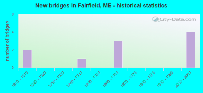
- New bridges - historical statistics
- 21910-1919
- 11940-1949
- 31960-1969
- 42000-2009

- Reconstructed bridges - Historical Statistics
- 11980-1989
- 01990-1999
- 12000-2009
- 12010-2019


- Bridge Condition - Deck
- 42.9%Very good
- 57.1%Good

- Bridge Condition - Superstructure
- 28.6%Very good
- 42.9%Good
- 14.3%Satisfactory
- 14.3%Fair

- Bridge Condition - Substructure
- 50.0%Good
- 40.0%Satisfactory
- 10.0%Poor

- Bridge Condition - Channel
- 80.0%Good
- 20.0%Satisfactory
Find on map >> Show street view
Structure Number: 1087, Location: RT-201 FST LEFT OVER BRG (Lat: 44.590011, Lng: -69.593481), Year Built: 1916, Status: Open, Structure Length: 3.20m (10.50ft), Average Future Daily Traffic: 53 (year 2034), Design Load: Railroad, Features Intersected: ISLAND AVENUE
Lanes under structure: 2, Owner: Railroad, Material/Design: Steel, Design/Construction: Girder and Floorbeam System, Number Of Spans In Main Unit: 1, Length of Maximum Span: 30.5m (100.1ft), Out-to-Out Width: 7.2m (23.6ft)
Condition: Substructure: Satisfactory, Structural Evaluation: Equal to present minimum criteria, Underclear: Superior to present desirable criteria, Designated Inspection Frequency: Every 24 months, Inspection Date: March 2021
Find on map >> Show street view
Structure Number: 1092, Location: RT-201AT BRIDGE FAIRFIELD (Lat: 44.589250, Lng: -69.594731), Year Built: 1917, Status: Open, Structure Length: 3.35m (10.99ft), Average Future Daily Traffic: 17,640 (year 2034), Design Load: Railroad, Features Intersected: MAIN STREET
Lanes under structure: 2, Owner: Railroad, Material/Design: Steel, Design/Construction: Girder and Floorbeam System, Number Of Spans In Main Unit: 1, Length of Maximum Span: 32.3m (106.0ft), Out-to-Out Width: 7.3m (24.0ft)
Condition: Substructure: Satisfactory, Underclear: Equal to present minimum criteria, Designated Inspection Frequency: Every 24 months, Inspection Date: March 2021
Find on map >> Show street view
Structure Number: 1522, Location: 0.1 MI E OF JCT RTE 201 (Lat: 44.587431, Lng: -69.591881), Route carried "on" structure: State highway 11, Year Built: 2003, Status: Open, Structure Length: 11.88m (38.98ft), Average Daily Traffic: 13,237 (year 2016), Truck Traffic: 5%, Average Future Daily Traffic: 18,532 (year 2036), Design Load: HS 25 or greater, Features Intersected: C CHANNEL KENNEBEC RIVER
Minimum Vertical Clearance: 30+ m (98+ ft), Kilometerpoint: 242.367, Lanes on structure: 2, Owner: State Highway Agency, Approaching Roadway Width: 12.8m (42.0ft), Skew: 1 degrees, Material/Design: Steel continuous, Design/Construction: Stringer/Multi-beam, Number Of Spans In Main Unit: 3, Length of Maximum Span: 45.1m (148.0ft), Curb or Sidewalk Widths: Left: 1.8m (5.9ft), Right: 0.0m, Curb-To-Curb Width: 12.0m (39.4ft), Out-to-Out Width: 14.8m (48.6ft)
Condition: Deck: Good, Superstructure: Very good, Substructure: Good, Channel: Good, Operating Rating: 54.4 metric tons, Method Used To Determine Operating Rating: Load and Resistance Factor Rating (LRFR) rating reported by rating factor(RF) method using HL-93 loadings, Inventory Rating: 41.8 metric tons, Method Used To Determine Inventory Rating: Load and Resistance Factor Rating (LRFR) rating reported by rating factor(RF) method using HL-93 loadings, Structural Evaluation: Better than present minimum criteria, Deck Geometry: Somewhat better than minimum adequacy, Waterway Adequacy: Equal to present desirable criteria, Approach Roadway Alignment: Equal to present desirable criteria, Designated Inspection Frequency: Every 24 months, Underwater Inspection Frequency: Every 60 months, Inspection Date: August 2020, Underwater Inspection Date: September 2020, Deck Structure Type: Concrete Precast Panels, Wearing Surface/Protective System: Wearing Surface: Bituminous, Membrane: Preformed Fabric
Find on map >> Show street view
Structure Number: 1523, Location: 150 FT E OF JCT US 201 (Lat: 44.587711, Lng: -69.593681), Route carried "on" structure: State highway 11, Year Built: 2003, Status: Open, Structure Length: 4.82m (15.81ft), Average Daily Traffic: 13,343 (year 2016), Truck Traffic: 5%, Average Future Daily Traffic: 18,680 (year 2036), Design Load: HS 25 or greater, Features Intersected: W CHANNEL KENNEBEC RIVER
Minimum Vertical Clearance: 30+ m (98+ ft), Kilometerpoint: 242.256, Lanes on structure: 3, Owner: State Highway Agency, Approaching Roadway Width: 12.8m (42.0ft), Skew: 1 degrees, Material/Design: Steel continuous, Design/Construction: Stringer/Multi-beam, Number Of Spans In Main Unit: 2, Length of Maximum Span: 22.9m (75.1ft), Curb or Sidewalk Widths: Left: 1.8m (5.9ft), Right: 0.0m, Curb-To-Curb Width: 13.8m (45.3ft), Out-to-Out Width: 16.6m (54.5ft)
Condition: Deck: Good, Superstructure: Very good, Substructure: Good, Channel: Good, Operating Rating: 51.8 metric tons, Method Used To Determine Operating Rating: Load and Resistance Factor Rating (LRFR) rating reported by rating factor(RF) method using HL-93 loadings, Inventory Rating: 40.2 metric tons, Method Used To Determine Inventory Rating: Load and Resistance Factor Rating (LRFR) rating reported by rating factor(RF) method using HL-93 loadings, Structural Evaluation: Better than present minimum criteria, Deck Geometry: Somewhat better than minimum adequacy, Waterway Adequacy: Equal to present desirable criteria, Approach Roadway Alignment: Equal to present desirable criteria, Designated Inspection Frequency: Every 24 months, Underwater Inspection Frequency: Every 60 months, Inspection Date: August 2020, Underwater Inspection Date: September 2020, Deck Structure Type: Concrete Precast Panels, Wearing Surface/Protective System: Wearing Surface: Bituminous, Membrane: Preformed Fabric
Find on map >> Show street view
Structure Number: 3106, Location: 0.2 MI E OF JCT RTE 201 (Lat: 44.587050, Lng: -69.589619), Route carried "on" structure: State highway 11, Year Built: 2003, Status: Open, Structure Length: 11.00m (36.09ft), Average Daily Traffic: 13,058 (year 2016), Truck Traffic: 5%, Average Future Daily Traffic: 18,281 (year 2036), Design Load: HS 25 or greater, Features Intersected: E CHANNEL KENNEBEC RIVER
Minimum Vertical Clearance: 30+ m (98+ ft), Kilometerpoint: 242.594, Lanes on structure: 2, Owner: State Highway Agency, Approaching Roadway Width: 12.8m (42.0ft), Material/Design: Steel continuous, Design/Construction: Stringer/Multi-beam, Number Of Spans In Main Unit: 3, Length of Maximum Span: 42.1m (138.1ft), Curb or Sidewalk Widths: Left: 1.8m (5.9ft), Right: 0.0m, Curb-To-Curb Width: 12.0m (39.4ft), Out-to-Out Width: 14.8m (48.6ft)
Condition: Deck: Good, Superstructure: Good, Substructure: Good, Channel: Good, Operating Rating: 59.3 metric tons, Method Used To Determine Operating Rating: Load and Resistance Factor Rating (LRFR) rating reported by rating factor(RF) method using HL-93 loadings, Inventory Rating: 46.0 metric tons, Method Used To Determine Inventory Rating: Load and Resistance Factor Rating (LRFR) rating reported by rating factor(RF) method using HL-93 loadings, Structural Evaluation: Better than present minimum criteria, Deck Geometry: Somewhat better than minimum adequacy, Waterway Adequacy: Equal to present desirable criteria, Approach Roadway Alignment: Equal to present desirable criteria, Designated Inspection Frequency: Every 24 months, Underwater Inspection Frequency: Every 60 months, Inspection Date: August 2020, Underwater Inspection Date: September 2020, Deck Structure Type: Concrete Precast Panels, Wearing Surface/Protective System: Wearing Surface: Bituminous, Membrane: Preformed Fabric
Find on map >> Show street view
Structure Number: 3707, Location: RT-201 5MI JUNE I95 (Lat: 44.582289, Lng: -69.602961), Year Built: 1948, Status: Open, Structure Length: 5.46m (17.91ft), Average Future Daily Traffic: 6,982 (year 2034), Features Intersected: STATE ROUTE 201
Lanes under structure: 2, Owner: Railroad, Material/Design: Steel, Design/Construction: Girder and Floorbeam System, Number Of Spans In Main Unit: 2, Length of Maximum Span: 24.4m (80.1ft), Out-to-Out Width: 9.4m (30.8ft)
Condition: Substructure: Poor, Underclear: High priority of corrective action, Designated Inspection Frequency: Every 24 months, Inspection Date: March 2021
Find on map >> Show street view
Structure Number: 5819, Location: 1 MI W OF JCT RTE US 201 (Lat: 44.594069, Lng: -69.615889), Route carried "on" structure: State highway 139, Year Built: 1960, Year Reconstructed: 2016, Status: Open, Structure Length: 8.58m (28.15ft), Average Daily Traffic: 8,723 (year 2016), Truck Traffic: 5%, Average Future Daily Traffic: 12,212 (year 2036), Design Load: H 20, Features Intersected: INTERSTATE 95
Minimum Vertical Clearance: 30+ m (98+ ft), Kilometerpoint: 74.545, Lanes on structure: 2, Lanes under structure: 4, Base Highway Network: Yes, Owner: State Highway Agency, Approaching Roadway Width: 10.4m (34.1ft), Skew: 1 degrees, Material/Design: Steel, Design/Construction: Stringer/Multi-beam, Number Of Spans In Main Unit: 5, Length of Maximum Span: 17.8m (58.4ft), Curb-To-Curb Width: 10.4m (34.1ft), Out-to-Out Width: 11.2m (36.7ft)
Condition: Deck: Very good, Superstructure: Satisfactory, Substructure: Satisfactory, Operating Rating: 69.0 metric tons, Method Used To Determine Operating Rating: Load and Resistance Factor Rating (LRFR) rating reported by rating factor(RF) method using HL-93 loadings, Inventory Rating: 53.5 metric tons, Method Used To Determine Inventory Rating: Load and Resistance Factor Rating (LRFR) rating reported by rating factor(RF) method using HL-93 loadings, Structural Evaluation: Equal to present minimum criteria, Deck Geometry: Meets minimum limits, Underclear: High priority of corrective action, Approach Roadway Alignment: Equal to present desirable criteria, Designated Inspection Frequency: Every 24 months, Inspection Date: May 2021, Deck Structure Type: Concrete Precast Panels, Wearing Surface/Protective System: Wearing Surface: Bituminous, Membrane: Preformed Fabric
Find on map >> Show street view
Structure Number: 5999, Location: 0.1 MI E OF 95 / US201 (Lat: 44.601811, Lng: -69.596161), Route carried "on" structure: State highway 95, Year Built: 1964, Year Reconstructed: 2013, Status: Open, Structure Length: 3.93m (12.89ft), Average Daily Traffic: 9,750 (year 2016), Truck Traffic: 10%, Average Future Daily Traffic: 13,650 (year 2036), Design Load: HS 20+Mod, Features Intersected: M C RR
Minimum Vertical Clearance: 30+ m (98+ ft), Kilometerpoint: 212.483, Lanes on structure: 4, Base Highway Network: Yes, Owner: State Highway Agency, Approaching Roadway Width: 12.8m (42.0ft), Skew: 31 degrees, Material/Design: Steel continuous, Design/Construction: Stringer/Multi-beam, Number Of Spans In Main Unit: 3, Length of Maximum Span: 14.6m (47.9ft), Curb or Sidewalk Widths: Left: 0.2m (0.7ft), Right: 0.2m (0.7ft), Curb-To-Curb Width: 20.1m (65.9ft), Out-to-Out Width: 26.5m (86.9ft)
Condition: Deck: Good, Superstructure: Fair, Substructure: Satisfactory, Operating Rating: 65.1 metric tons, Method Used To Determine Operating Rating: Load and Resistance Factor Rating (LRFR) rating reported by rating factor(RF) method using HL-93 loadings, Inventory Rating: 50.2 metric tons, Method Used To Determine Inventory Rating: Load and Resistance Factor Rating (LRFR) rating reported by rating factor(RF) method using HL-93 loadings, Structural Evaluation: Somewhat better than minimum adequacy, Deck Geometry: Equal to present minimum criteria, Underclear: Somewhat better than minimum adequacy, Approach Roadway Alignment: Equal to present desirable criteria, Designated Inspection Frequency: Every 24 months, Inspection Date: September 2021, Deck Structure Type: Concrete Cast-file-Place, Wearing Surface/Protective System: Wearing Surface: Bituminous, Membrane: Preformed Fabric
Find on map >> Show street view
Structure Number: 6, Location: 0.2 MI NE 95 / US201 (Lat: 44.601689, Lng: -69.592589), Route carried "on" structure: State highway 95, Year Built: 1964, Year Reconstructed: 1987, Status: Open, Structure Length: 28.79m (94.46ft), Average Daily Traffic: 9,750 (year 2016), Truck Traffic: 5%, Average Future Daily Traffic: 13,650 (year 2036), Design Load: HS 20+Mod, Features Intersected: KENNEBEC RIVER
Minimum Vertical Clearance: 30+ m (98+ ft), Kilometerpoint: 212.707, Lanes on structure: 2, Base Highway Network: Yes, Owner: State Highway Agency, Approaching Roadway Width: 10.7m (35.1ft), Skew: 2 degrees, Material/Design: Steel continuous, Design/Construction: Stringer/Multi-beam, Number Of Spans In Main Unit: 5, Number Of Approach Spans: 2, Length of Maximum Span: 47.9m (157.2ft), Curb or Sidewalk Widths: Left: 0.1m (0.3ft), Right: 0.1m (0.3ft), Curb-To-Curb Width: 9.1m (29.9ft), Out-to-Out Width: 10.7m (35.1ft)
Condition: Deck: Very good, Superstructure: Good, Substructure: Good, Channel: Satisfactory, Operating Rating: 43.1 metric tons, Method Used To Determine Operating Rating: Load and Resistance Factor Rating (LRFR) rating reported by rating factor(RF) method using HL-93 loadings, Inventory Rating: 33.0 metric tons, Method Used To Determine Inventory Rating: Load and Resistance Factor Rating (LRFR) rating reported by rating factor(RF) method using HL-93 loadings, Structural Evaluation: Better than present minimum criteria, Deck Geometry: Meets minimum limits, Waterway Adequacy: Superior to present desirable criteria, Approach Roadway Alignment: Equal to present desirable criteria, Designated Inspection Frequency: Every 24 months, Underwater Inspection Frequency: Every 60 months, Inspection Date: December 2021, Underwater Inspection Date: October 2020, Deck Structure Type: Concrete Cast-file-Place, Wearing Surface/Protective System: Wearing Surface: Bituminous, Membrane: Preformed Fabric
Find on map >> Show street view
Structure Number: 6427, Location: .1 m So of int. w/ Rt 201 (Lat: 44.599369, Lng: -69.602081), Route carried "on" structure: City street , Year Built: 2005, Status: Open, Structure Length: 2.20m (7.22ft), Average Daily Traffic: 250 (year 2016), Truck Traffic: 5%, Average Future Daily Traffic: 400 (year 2036), Design Load: HS 25 or greater, Features Intersected: Emery Brook, Facility Carried by Structure: Eskelund Drive
Minimum Vertical Clearance: 30+ m (98+ ft), Kilometerpoint: 0.241, Lanes on structure: 2, Owner: Town or Township Highway Agency, Approaching Roadway Width: 10.4m (34.1ft), Material/Design: Wood or Timber, Design/Construction: Stringer/Multi-beam, Number Of Spans In Main Unit: 1, Length of Maximum Span: 21.4m (70.2ft), Curb-To-Curb Width: 9.1m (29.9ft), Out-to-Out Width: 10.6m (34.8ft)
Condition: Deck: Very good, Superstructure: Good, Substructure: Good, Channel: Good, Operating Rating: 49.9 metric tons, Method Used To Determine Operating Rating: Load and Resistance Factor Rating (LRFR) rating reported by rating factor(RF) method using HL-93 loadings, Inventory Rating: 38.6 metric tons, Method Used To Determine Inventory Rating: Load and Resistance Factor Rating (LRFR) rating reported by rating factor(RF) method using HL-93 loadings, Structural Evaluation: Better than present minimum criteria, Deck Geometry: Equal to present minimum criteria, Waterway Adequacy: Superior to present desirable criteria, Approach Roadway Alignment: Equal to present desirable criteria, Designated Inspection Frequency: Every 24 months, Inspection Date: September 2021, Deck Structure Type: Concrete Cast-file-Place, Wearing Surface/Protective System: Wearing Surface: Integral Concrete
Find on map >> Show street view
Location: RT-201 FST LEFT OVER BRG (Lat: 44.589989, Lng: -69.593589), Route carried "on" structure: Service 72500, Structure Length: 0. m, Average Daily Traffic: 35 (year 2014), Truck Traffic: 5%, Features Intersected: MAINE CENTRAL RAIL, Facility Carried by Structure: ISLAND AVENUE
Minimum Vertical Clearance: 6.12m (20.08ft), Kilometerpoint: 0.257, Lanes on structure: 2, Length of Maximum Span: 0.0m
Find on map >> Show street view
Location: RT-201 5MI JUNE I95 (Lat: 44.582197, Lng: -69.603097), Route carried "under" structure: State lands road 72310, Structure Length: 0. m, Average Daily Traffic: 4,987 (year 2014), Truck Traffic: 9%, Features Intersected: MAINE CENTRAL RAIL, Facility Carried by Structure: STATE ROUTE 201
Minimum Vertical Clearance: 4.19m (13.75ft), Kilometerpoint: 85.215, Lanes on structure: 4, Length of Maximum Span: 0.0m