Bridge Statistics for Fairless Hills, Pennsylvania (PA)
Condition, Traffic, Stress, Structural Evaluation, Project Costs
- National Bridge Inventory (NBI) Statistics
- 11Number of bridges
- 85ft / 26.3mTotal length
- $3,895,000Total costs
- 182,256Total average daily traffic
- 10,744Total average daily truck traffic
- National Bridge Inventory (NBI) Registered Bridges for Fairless Hills
- No street view available for this location
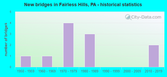
- New bridges - historical statistics
- 11950-1959
- 11960-1969
- 41970-1979
- 31980-1989
- 22010-2019
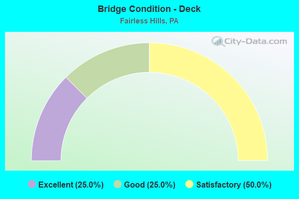
- Bridge Condition - Deck
- 25.0%Excellent
- 25.0%Good
- 50.0%Satisfactory
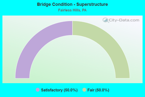
- Bridge Condition - Superstructure
- 50.0%Satisfactory
- 50.0%Fair
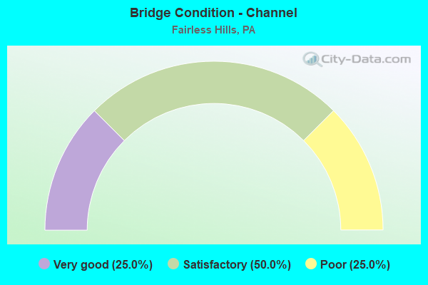
- Bridge Condition - Channel
- 25.0%Very good
- 50.0%Satisfactory
- 25.0%Poor
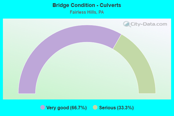
- Bridge Condition - Culverts
- 66.7%Very good
- 33.3%Serious
Find on map >> Show street view
Structure Number: 7228, Location: 2MI.N.LANGHORNE 37K08 (Lat: 40.189239, Lng: -74.866697), Route carried "on" structure: State highway , Year Built: 1969, Status: Open, Structure Length: 7.77m (25.49ft), Average Daily Traffic: 31,165 (year 2022), Truck Traffic: 2%, Average Future Daily Traffic: 39,986 (year 2032), Design Load: HS 20, Features Intersected: CSX & NSRC, Facility Carried by Structure: OXFORD VALLEY ROAD
Minimum Vertical Clearance: 30+ m (98+ ft), Kilometerpoint: 10.638, Lanes on structure: 4, Base Highway Network: Yes, Owner: State Highway Agency, Approaching Roadway Width: 26.2m (86.0ft), Skew: 33 degrees, Material/Design: Prestressed concrete, Design/Construction: Box Beam or Girders - Single/Spread, Number Of Spans In Main Unit: 4, Length of Maximum Span: 22.9m (75.1ft), Curb or Sidewalk Widths: Left: 0.2m (0.7ft), Right: 0.2m (0.7ft), Curb-To-Curb Width: 26.2m (86.0ft), Out-to-Out Width: 26.8m (87.9ft)
Condition: Deck: Satisfactory, Superstructure: Fair, Substructure: Satisfactory, Operating Rating: 86.2 metric tons, Method Used To Determine Operating Rating: Load Factor (LF), Inventory Rating: 44.5 metric tons, Method Used To Determine Inventory Rating: Load Factor (LF), Structural Evaluation: Somewhat better than minimum adequacy, Deck Geometry: Superior to present desirable criteria, Underclear: High priority of corrective action, Approach Roadway Alignment: Equal to present desirable criteria, Length Of Structure Improvement: 8.70m (28.54ft), Designated Inspection Frequency: Every 24 months, Inspection Date: June 2020, Bridge Improvement Cost: $94,000, Roadway Improvement Cost: $276,000, Total Project Cost: $1,266,000, Deck Structure Type: Concrete Cast-file-Place, Wearing Surface/Protective System: Wearing Surface: Monolithic Concrete
Find on map >> Show street view
Structure Number: 7229, Location: 2MI.N.LANGHORNE 37K07 (Lat: 40.193361, Lng: -74.864894), Route carried "on" structure: State highway , Year Built: 1972, Year Reconstructed: 2017, Status: Open, Structure Length: 5.09m (16.70ft), Average Daily Traffic: 31,165 (year 2022), Truck Traffic: 2%, Average Future Daily Traffic: 39,487 (year 2032), Design Load: HS 20, Features Intersected: US 1 BYPASS (LR 281), Facility Carried by Structure: OXFORD VALLEY ROAD
Minimum Vertical Clearance: 30+ m (98+ ft), Kilometerpoint: 10.638, Lanes on structure: 4, Lanes under structure: 4, Base Highway Network: Yes, Owner: State Highway Agency, Approaching Roadway Width: 28.3m (92.8ft), Skew: 20 degrees, Material/Design: Steel, Design/Construction: Stringer/Multi-beam, Number Of Spans In Main Unit: 1, Number Of Approach Spans: 2, Length of Maximum Span: 30.5m (100.1ft), Curb or Sidewalk Widths: Left: 0.2m (0.7ft), Right: 0.2m (0.7ft), Curb-To-Curb Width: 26.9m (88.3ft), Out-to-Out Width: 27.4m (89.9ft)
Condition: Deck: Good, Superstructure: Satisfactory, Substructure: Satisfactory, Operating Rating: 57.2 metric tons, Method Used To Determine Operating Rating: Load Factor (LF), Inventory Rating: 33.6 metric tons, Method Used To Determine Inventory Rating: Load Factor (LF), Structural Evaluation: Equal to present minimum criteria, Deck Geometry: Superior to present desirable criteria, Underclear: High priority of corrective action, Approach Roadway Alignment: Equal to present desirable criteria, Length Of Structure Improvement: 6.10m (20.01ft), Designated Inspection Frequency: Every 24 months, Inspection Date: September 2021, Bridge Improvement Cost: $160,000, Roadway Improvement Cost: $471,000, Total Project Cost: $2,160,000, Deck Structure Type: Concrete Cast-file-Place, Wearing Surface/Protective System: Wearing Surface: Latex Concrete
Find on map >> Show street view
Structure Number: 7304, Location: WEST WOOLSTON DR. 38E07 (Lat: 40.195433, Lng: -74.831744), Route carried "on" structure: State highway , Year Built: 1985, Status: Open, Structure Length: 6.83m (22.41ft), Average Daily Traffic: 7,243 (year 2022), Truck Traffic: 4%, Average Future Daily Traffic: 8,743 (year 2032), Design Load: HS 25 or greater, Features Intersected: US-1, Facility Carried by Structure: STONEY HILL ROAD
Minimum Vertical Clearance: 30+ m (98+ ft), Kilometerpoint: 0.758, Lanes on structure: 2, Lanes under structure: 5, Owner: State Highway Agency, Approaching Roadway Width: 14.9m (48.9ft), Skew: 1 degrees, Material/Design: Prestressed concrete, Design/Construction: Box Beam or Girders - Multiple, Number Of Spans In Main Unit: 1, Number Of Approach Spans: 2, Length of Maximum Span: 39.3m (128.9ft), Curb or Sidewalk Widths: Left: 0.2m (0.7ft), Right: 0.2m (0.7ft), Curb-To-Curb Width: 14.9m (48.9ft), Out-to-Out Width: 15.8m (51.8ft)
Condition: Deck: Satisfactory, Superstructure: Fair, Substructure: Satisfactory, Operating Rating: 39.0 metric tons, Method Used To Determine Operating Rating: Load Factor (LF), Inventory Rating: 23.6 metric tons, Method Used To Determine Inventory Rating: Load Factor (LF), Structural Evaluation: Somewhat better than minimum adequacy, Deck Geometry: Superior to present desirable criteria, Underclear: High priority of corrective action, Approach Roadway Alignment: Better than present minimum criteria, Length Of Structure Improvement: 7.90m (25.92ft), Designated Inspection Frequency: Every 24 months, Inspection Date: Febuary 2020, Bridge Improvement Cost: $35,000, Roadway Improvement Cost: $102,000, Total Project Cost: $469,000, Deck Structure Type: Concrete Cast-file-Place, Wearing Surface/Protective System: Wearing Surface: Monolithic Concrete, Deck Protection: Epoxy Coated Reinforcing
Find on map >> Show street view
Structure Number: 7588, Location: 1.8 MI SE OF US 1 3263-C4 (Lat: 40.164075, Lng: -74.859956), Route carried "on" structure: City street , Year Built: 1978, Year Reconstructed: 2019, Status: Open, Structure Length: 4.15m (13.62ft), Average Daily Traffic: 1,000 (year 2012), Average Future Daily Traffic: 1,400 (year 2032), Design Load: HS 20, Features Intersected: QUEEN ANNE CREEK, Facility Carried by Structure: WISTAR ROAD(T331)
Minimum Vertical Clearance: 30+ m (98+ ft), Kilometerpoint: 0.000, Lanes on structure: 2, Owner: Town or Township Highway Agency, Approaching Roadway Width: 11.0m (36.1ft), Material/Design: Prestressed concrete, Design/Construction: Stringer/Multi-beam, Number Of Spans In Main Unit: 2, Length of Maximum Span: 20.4m (66.9ft), Curb or Sidewalk Widths: Left: 1.6m (5.2ft), Right: 0.2m (0.7ft), Curb-To-Curb Width: 10.9m (35.8ft), Out-to-Out Width: 13.2m (43.3ft)
Condition: Deck: Excellent, Superstructure: Satisfactory, Substructure: Satisfactory, Channel: Satisfactory, Operating Rating: 61.7 metric tons, Method Used To Determine Operating Rating: Field evaluation and documented engineering judgment, Inventory Rating: 37.2 metric tons, Method Used To Determine Inventory Rating: Field evaluation and documented engineering judgment, Structural Evaluation: Equal to present minimum criteria, Deck Geometry: Equal to present minimum criteria, Waterway Adequacy: Better than present minimum criteria, Approach Roadway Alignment: Better than present minimum criteria, Length Of Structure Improvement: 5.00m (16.40ft), Designated Inspection Frequency: Every 24 months, Inspection Date: April 2020, Deck Structure Type: Concrete Cast-file-Place, Wearing Surface/Protective System: Wearing Surface: Monolithic Concrete, Deck Protection: Epoxy Coated Reinforcing
Find on map >> Show street view
Structure Number: 7607, Location: 900' SE OF SR2018 3263-B3 (Lat: 40.171536, Lng: -74.864333), Route carried "on" structure: City street , Year Built: 1953, Status: Posted for load, Structure Length: 0.91m (2.99ft), Average Daily Traffic: 5,000 (year 2012), Average Future Daily Traffic: 7,000 (year 2032), Features Intersected: TRIB TO QUEEN ANNE CREEK, Facility Carried by Structure: S OLDS BOULEVARD
Minimum Vertical Clearance: 30+ m (98+ ft), Kilometerpoint: 0.000, Lanes on structure: 2, Owner: Town or Township Highway Agency, Approaching Roadway Width: 11.3m (37.1ft), Material/Design: Steel, Design/Construction: Culvert, Number Of Spans In Main Unit: 4, Length of Maximum Span: 1.8m (5.9ft), Curb or Sidewalk Widths: Left: 1.1m (3.6ft), Right: 0.6m (2.0ft), Curb-To-Curb Width: 11.0m (36.1ft), Out-to-Out Width: 13.4m (44.0ft)
Condition: Channel: Poor, Culverts: Serious, Operating Rating: 21.8 metric tons, Method Used To Determine Operating Rating: Field evaluation and documented engineering judgment, Inventory Rating: 12.7 metric tons, Method Used To Determine Inventory Rating: Field evaluation and documented engineering judgment, Structural Evaluation: High priority of corrective action, Deck Geometry: Somewhat better than minimum adequacy, Waterway Adequacy: Better than present minimum criteria, Approach Roadway Alignment: Equal to present desirable criteria, Bridge Posting: Required (Relationship of Operating Rating to Maximum Legal Load: 30.0 - 39.9% below), Length Of Structure Improvement: 1.80m (5.91ft), Designated Inspection Frequency: Every 24 months, Other Special Inspection Frequency: Every 12 months, Inspection Date: June 2020, Other Special Inspection Date: June 2021
Find on map >> Show street view
Structure Number: 48679, Location: 0.4MI W OF SR2051 3263-C3 (Lat: 40.169736, Lng: -74.858064), Route carried "on" structure: City street , Year Built: 2013, Status: Open, Structure Length: 0.85m (2.79ft), Average Daily Traffic: 5,200 (year 2014), Average Future Daily Traffic: 7,200 (year 2034), Design Load: HS 25 or greater, Features Intersected: QUEEN ANNE CREEK, Facility Carried by Structure: S OLDS BOULEVARD
Minimum Vertical Clearance: 30+ m (98+ ft), Kilometerpoint: 0.000, Lanes on structure: 2, Owner: Town or Township Highway Agency, Approaching Roadway Width: 11.0m (36.1ft), Material/Design: Concrete, Design/Construction: Culvert, Number Of Spans In Main Unit: 1, Length of Maximum Span: 8.5m (27.9ft), Curb or Sidewalk Widths: Left: 1.0m (3.3ft), Right: 1.7m (5.6ft), Curb-To-Curb Width: 11.0m (36.1ft), Out-to-Out Width: 14.6m (47.9ft)
Condition: Channel: Satisfactory, Culverts: Very good, Operating Rating: 68.9 metric tons, Method Used To Determine Operating Rating: Assigned rating based on Load Factor Design (LFD) reported in metric tons, Inventory Rating: 46.3 metric tons, Method Used To Determine Inventory Rating: Assigned rating based on Load Factor Design (LFD) reported in metric tons, Structural Evaluation: Equal to present desirable criteria, Deck Geometry: Meets minimum limits, Waterway Adequacy: Better than present minimum criteria, Approach Roadway Alignment: Equal to present desirable criteria, Designated Inspection Frequency: Every 24 months, Inspection Date: June 2020
Find on map >> Show street view
Structure Number: 54107, Location: BILLBOARD 38C08/3151E10 (Lat: 40.188331, Lng: -74.845817), Route carried "on" structure: US 1B, Year Built: 2018, Status: Open, Structure Length: 0.67m (2.20ft), Average Daily Traffic: 15,637 (year 2022), Truck Traffic: 4%, Average Future Daily Traffic: 18,340 (year 2032), Design Load: HL 93, Features Intersected: QUEEN ANNE CREEK, Facility Carried by Structure: LINCOLN HIGHWAY
Minimum Vertical Clearance: 30+ m (98+ ft), Kilometerpoint: 11.549, Lanes on structure: 2, Base Highway Network: Yes, Owner: State Highway Agency, Maintenance Responsibility: Private, Approaching Roadway Width: 16.8m (55.1ft), Material/Design: Concrete, Design/Construction: Culvert, Number Of Spans In Main Unit: 1, Length of Maximum Span: 6.1m (20.0ft), Curb-To-Curb Width: 19.5m (64.0ft), Out-to-Out Width: 20.4m (66.9ft)
Condition: Channel: Very good, Culverts: Very good, Operating Rating: 60.3 metric tons, Method Used To Determine Operating Rating: Assigned ratings based on Load and Resistance Factor Design (LRFD) reported by rating factor (RF) using HL93 loadings, Inventory Rating: 37.9 metric tons, Method Used To Determine Inventory Rating: Assigned ratings based on Load and Resistance Factor Design (LRFD) reported by rating factor (RF) using HL93 loadings, Structural Evaluation: Equal to present desirable criteria, Deck Geometry: Superior to present desirable criteria, Waterway Adequacy: Superior to present desirable criteria, Approach Roadway Alignment: Equal to present desirable criteria, Designated Inspection Frequency: Every 24 months, Inspection Date: November 2021, Wearing Surface/Protective System: Wearing Surface: Bituminous, Membrane: Preformed Fabric
Find on map >> Show street view
Structure Number: 7229, Location: 2MI.N.LANGHORNE 37K07 (Lat: 40.193361, Lng: -74.864894), Route carried "under" structure: US 1, Year Built: 1972, Structure Length: 0. m, Average Daily Traffic: 22,170 (year 2020), Truck Traffic: 10%, Features Intersected: US 1 BYPASS (LR 281), Facility Carried by Structure: OXFORD VALLEY ROAD
Minimum Vertical Clearance: 4.36m (14.30ft), Kilometerpoint: 13.391, Lanes on structure: 4, Lanes under structure: 2, Material/Design: Steel, Design/Construction: Stringer/Multi-beam, Length of Maximum Span: 30.5m (100.1ft)
Find on map >> Show street view
Structure Number: 7229, Location: 2MI.N.LANGHORNE 37K07 (Lat: 40.193361, Lng: -74.864894), Route carried "under" structure: US 1, Year Built: 1972, Structure Length: 0. m, Average Daily Traffic: 20,753 (year 2020), Truck Traffic: 10%, Features Intersected: US 1 BYPASS (LR 281), Facility Carried by Structure: OXFORD VALLEY ROAD
Minimum Vertical Clearance: 4.42m (14.50ft), Kilometerpoint: 13.366, Lanes on structure: 4, Lanes under structure: 2, Material/Design: Steel, Design/Construction: Stringer/Multi-beam, Length of Maximum Span: 30.5m (100.1ft)
Find on map >> Show street view
Structure Number: 7304, Location: WEST WOOLSTON DR. 38E07 (Lat: 40.195433, Lng: -74.831744), Route carried "under" structure: US 1, Year Built: 1985, Structure Length: 0. m, Average Daily Traffic: 20,753 (year 2020), Truck Traffic: 10%, Features Intersected: US-1, Facility Carried by Structure: STONEY HILL ROAD
Minimum Vertical Clearance: 5.46m (17.91ft), Kilometerpoint: 16.206, Lanes on structure: 2, Lanes under structure: 3, Material/Design: Prestressed concrete, Design/Construction: Box Beam or Girders - Multiple, Length of Maximum Span: 39.3m (128.9ft)
Find on map >> Show street view
Structure Number: 7304, Location: WEST WOOLSTON DR. 38E07 (Lat: 40.195433, Lng: -74.831744), Route carried "under" structure: US 1, Year Built: 1985, Structure Length: 0. m, Average Daily Traffic: 22,170 (year 2020), Truck Traffic: 10%, Features Intersected: US-1, Facility Carried by Structure: STONEY HILL ROAD
Minimum Vertical Clearance: 4.60m (15.09ft), Kilometerpoint: 16.227, Lanes on structure: 2, Lanes under structure: 2, Material/Design: Prestressed concrete, Design/Construction: Box Beam or Girders - Multiple, Length of Maximum Span: 39.3m (128.9ft)