Bridge Statistics for Fairmount, Colorado (CO)
Condition, Traffic, Stress, Structural Evaluation, Project Costs
- National Bridge Inventory (NBI) Statistics
- 18Number of bridges
- 75ft / 23.5mTotal length
- 150,209Total average daily traffic
- 7,057Total average daily truck traffic
- National Bridge Inventory (NBI) Registered Bridges for Fairmount
- No street view available for this location
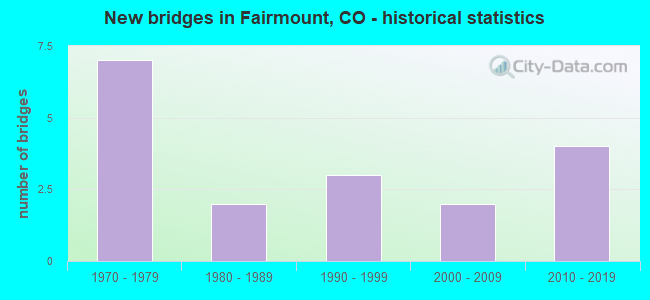
- New bridges - historical statistics
- 71970-1979
- 21980-1989
- 31990-1999
- 22000-2009
- 42010-2019
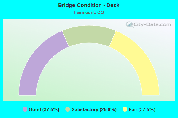
- Bridge Condition - Deck
- 37.5%Good
- 25.0%Satisfactory
- 37.5%Fair
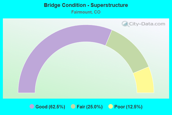
- Bridge Condition - Superstructure
- 62.5%Good
- 25.0%Fair
- 12.5%Poor
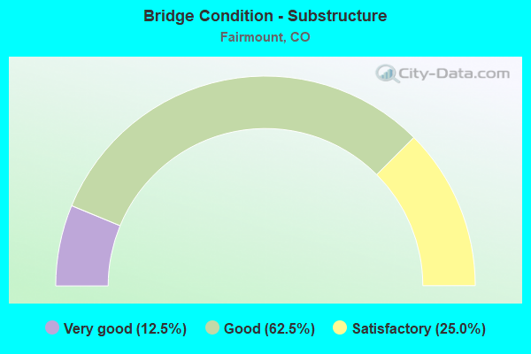
- Bridge Condition - Substructure
- 12.5%Very good
- 62.5%Good
- 25.0%Satisfactory
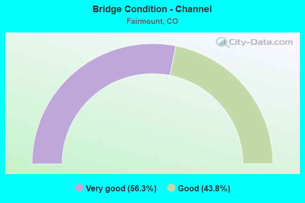
- Bridge Condition - Channel
- 56.3%Very good
- 43.8%Good
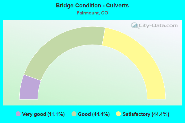
- Bridge Condition - Culverts
- 11.1%Very good
- 44.4%Good
- 44.4%Satisfactory
Find on map >> Show street view
Structure Number: E-16-HQ, Location: 2.9 MI E OF JCT SH 93 (Lat: 39.772667, Lng: -105.174586), Route carried "on" structure: City street , Year Built: 1973, Status: Open, Structure Length: 6.25m (20.51ft), Average Daily Traffic: 18,523 (year 2021), Truck Traffic: 9%, Average Future Daily Traffic: 21,302 (year 2041), Design Load: HS 20, Features Intersected: SH 58 ML, Facility Carried by Structure: MCINTYRE STREET
Minimum Vertical Clearance: 30+ m (98+ ft), Kilometerpoint: 1.087, Lanes on structure: 6, Lanes under structure: 4, Base Highway Network: Yes, Owner: State Highway Agency, Approaching Roadway Width: 25.3m (83.0ft), Skew: 1 degrees, Material/Design: Concrete continuous, Design/Construction: Box Beam or Girders - Multiple, Number Of Spans In Main Unit: 2, Length of Maximum Span: 30.8m (101.0ft), Curb-To-Curb Width: 25.0m (82.0ft), Out-to-Out Width: 25.7m (84.3ft)
Condition: Deck: Satisfactory, Superstructure: Poor, Substructure: Good, Operating Rating: 52.8 metric tons, Method Used To Determine Operating Rating: Load Factor (LF), Inventory Rating: 31.7 metric tons, Method Used To Determine Inventory Rating: Load Factor (LF), Structural Evaluation: Meets minimum limits, Deck Geometry: Somewhat better than minimum adequacy, Underclear: Better than present minimum criteria, Approach Roadway Alignment: Equal to present desirable criteria, Designated Inspection Frequency: Every 24 months, Inspection Date: June 2021, Deck Structure Type: Concrete Cast-file-Place, Wearing Surface/Protective System: Wearing Surface: Bituminous, Membrane: Built-up
Find on map >> Show street view
Structure Number: E-16-LG, Location: AT W. 58TH AVE (Lat: 39.802117, Lng: -105.224328), Route carried "on" structure: State highway 93A, Year Built: 1984, Status: Open, Structure Length: 0.88m (2.89ft), Average Daily Traffic: 24,000 (year 2020), Truck Traffic: 6%, Average Future Daily Traffic: 29,520 (year 2040), Design Load: HS 20, Features Intersected: VAN BIBBER CREEK, Facility Carried by Structure: SH 93 ML
Minimum Vertical Clearance: 30+ m (98+ ft), Kilometerpoint: 5.607, Lanes on structure: 4, Base Highway Network: Yes, Owner: State Highway Agency, Approaching Roadway Width: 20.1m (65.9ft), Material/Design: Concrete, Design/Construction: Culvert, Number Of Spans In Main Unit: 2, Length of Maximum Span: 4.3m (14.1ft), Out-to-Out Width: 58.2m (190.9ft)
Condition: Channel: Good, Culverts: Satisfactory, Operating Rating: 36.3 metric tons, Method Used To Determine Operating Rating: Field evaluation and documented engineering judgment, Inventory Rating: 32.7 metric tons, Method Used To Determine Inventory Rating: Field evaluation and documented engineering judgment, Structural Evaluation: Equal to present minimum criteria, Waterway Adequacy: Better than present minimum criteria, Approach Roadway Alignment: Equal to present desirable criteria, Designated Inspection Frequency: Every 48 months, Inspection Date: July 2020
Find on map >> Show street view
Structure Number: E-24-103, Location: JUST NORTH OF 60TH PLACE (Lat: 39.805036, Lng: -105.216392), Route carried "on" structure: County highway , Year Built: 1972, Status: Open, Structure Length: 1.65m (5.41ft), Average Daily Traffic: 160 (year 2021), Truck Traffic: 2%, Average Future Daily Traffic: 184 (year 2041), Design Load: HS 20, Features Intersected: VAN BIBBER CREEK, Facility Carried by Structure: DUNRAVEN STREET
Minimum Vertical Clearance: 30+ m (98+ ft), Kilometerpoint: 0.297, Lanes on structure: 2, Owner: County Highway Agency, Approaching Roadway Width: 10.4m (34.1ft), Skew: 4 degrees, Material/Design: Prestressed concrete, Design/Construction: Tee Beam, Number Of Spans In Main Unit: 1, Length of Maximum Span: 15.1m (49.5ft), Curb or Sidewalk Widths: Left: 1.2m (3.9ft), Right: 1.2m (3.9ft), Curb-To-Curb Width: 10.4m (34.1ft), Out-to-Out Width: 13.4m (44.0ft)
Condition: Deck: Fair, Superstructure: Fair, Substructure: Satisfactory, Channel: Very good, Operating Rating: 36.3 metric tons, Method Used To Determine Operating Rating: Field evaluation and documented engineering judgment, Inventory Rating: 14.8 metric tons, Method Used To Determine Inventory Rating: Load Factor (LF), Structural Evaluation: Meets minimum limits, Deck Geometry: Better than present minimum criteria, Waterway Adequacy: Equal to present desirable criteria, Approach Roadway Alignment: Equal to present desirable criteria, Designated Inspection Frequency: Every 24 months, Inspection Date: March 2021, Deck Structure Type: Concrete Cast-file-Place, Wearing Surface/Protective System: Wearing Surface: Monolithic Concrete
Find on map >> Show street view
Structure Number: E-24-104, Location: JUST SOUTH OF 61ST AVENUE (Lat: 39.806428, Lng: -105.212797), Route carried "on" structure: County highway , Year Built: 1972, Status: Open, Structure Length: 1.16m (3.81ft), Average Daily Traffic: 639 (year 2021), Truck Traffic: 4%, Average Future Daily Traffic: 734 (year 2041), Design Load: HS 20, Features Intersected: VAN BIBBER CREEK, Facility Carried by Structure: CRESTONE STREET
Minimum Vertical Clearance: 30+ m (98+ ft), Kilometerpoint: 0.503, Lanes on structure: 2, Owner: County Highway Agency, Approaching Roadway Width: 13.4m (44.0ft), Material/Design: Prestressed concrete, Design/Construction: Tee Beam, Number Of Spans In Main Unit: 1, Length of Maximum Span: 10.7m (35.1ft), Curb or Sidewalk Widths: Left: 1.2m (3.9ft), Right: 1.2m (3.9ft), Curb-To-Curb Width: 13.4m (44.0ft), Out-to-Out Width: 16.5m (54.1ft)
Condition: Deck: Fair, Superstructure: Good, Substructure: Good, Channel: Very good, Operating Rating: 36.3 metric tons, Method Used To Determine Operating Rating: Field evaluation and documented engineering judgment, Inventory Rating: 30.5 metric tons, Method Used To Determine Inventory Rating: Load Factor (LF), Structural Evaluation: Better than present minimum criteria, Deck Geometry: Superior to present desirable criteria, Waterway Adequacy: Equal to present desirable criteria, Approach Roadway Alignment: Equal to present desirable criteria, Designated Inspection Frequency: Every 24 months, Inspection Date: Febuary 2021, Deck Structure Type: Concrete Cast-file-Place, Wearing Surface/Protective System: Wearing Surface: Monolithic Concrete
Find on map >> Show street view
Structure Number: E-24-105, Location: 0.1 M N OF 58TH AVENUE (Lat: 39.804000, Lng: -105.218392), Route carried "on" structure: County highway , Year Built: 1999, Status: Open, Structure Length: 0.82m (2.69ft), Average Daily Traffic: 908 (year 2021), Average Future Daily Traffic: 1,045 (year 2041), Features Intersected: VAN BIBBER CREEK, Facility Carried by Structure: EL DIENTE ST
Minimum Vertical Clearance: 30+ m (98+ ft), Kilometerpoint: 0.077, Lanes on structure: 2, Owner: County Highway Agency, Approaching Roadway Width: 10.8m (35.4ft), Material/Design: Concrete, Design/Construction: Culvert, Number Of Spans In Main Unit: 2, Length of Maximum Span: 4.3m (14.1ft), Curb or Sidewalk Widths: Left: 1.4m (4.6ft), Right: 1.4m (4.6ft), Curb-To-Curb Width: 10.8m (35.4ft), Out-to-Out Width: 18.3m (60.0ft)
Condition: Channel: Good, Culverts: Satisfactory, Inventory Rating: 94.9 metric tons, Method Used To Determine Inventory Rating: Load Factor (LF), Structural Evaluation: Equal to present minimum criteria, Deck Geometry: Equal to present minimum criteria, Waterway Adequacy: Equal to present desirable criteria, Approach Roadway Alignment: Equal to present desirable criteria, Designated Inspection Frequency: Every 24 months, Inspection Date: March 2021
Find on map >> Show street view
Structure Number: E-24-106, Location: JUST NORTH OF 58TH AVE. (Lat: 39.802333, Lng: -105.221667), Route carried "on" structure: County highway , Year Built: 2013, Status: Open, Structure Length: 1.15m (3.77ft), Average Daily Traffic: 1,254 (year 2021), Truck Traffic: 1%, Average Future Daily Traffic: 1,442 (year 2041), Features Intersected: VAN BIBBER CREEK, Facility Carried by Structure: GILBERT STREET
Minimum Vertical Clearance: 30+ m (98+ ft), Kilometerpoint: 0.248, Lanes on structure: 2, Owner: County Highway Agency, Approaching Roadway Width: 11.0m (36.1ft), Material/Design: Concrete, Design/Construction: Culvert, Number Of Spans In Main Unit: 3, Length of Maximum Span: 3.7m (12.1ft), Curb or Sidewalk Widths: Left: 2.6m (8.5ft), Right: 2.6m (8.5ft), Out-to-Out Width: 30.5m (100.1ft)
Condition: Channel: Very good, Culverts: Satisfactory, Operating Rating: 36.3 metric tons, Method Used To Determine Operating Rating: Field evaluation and documented engineering judgment, Inventory Rating: 32.7 metric tons, Method Used To Determine Inventory Rating: Field evaluation and documented engineering judgment, Structural Evaluation: Equal to present minimum criteria, Waterway Adequacy: Equal to present desirable criteria, Approach Roadway Alignment: Equal to present desirable criteria, Designated Inspection Frequency: Every 24 months, Inspection Date: March 2021
Find on map >> Show street view
Structure Number: E-24-93, Location: 1.1 MI E OF HWY 93 (Lat: 39.804664, Lng: -105.204319), Route carried "on" structure: County highway , Year Built: 1976, Status: Open, Structure Length: 0.80m (2.62ft), Average Daily Traffic: 5,380 (year 2021), Truck Traffic: 9%, Average Future Daily Traffic: 6,187 (year 2041), Design Load: HS 20, Features Intersected: BOULDER DIVERSION CANAL, Facility Carried by Structure: 60TH AVENUE
Minimum Vertical Clearance: 30+ m (98+ ft), Kilometerpoint: 1.860, Lanes on structure: 2, Owner: County Highway Agency, Approaching Roadway Width: 7.9m (25.9ft), Skew: 1 degrees, Material/Design: Steel, Design/Construction: Stringer/Multi-beam, Number Of Spans In Main Unit: 1, Length of Maximum Span: 6.9m (22.6ft), Curb or Sidewalk Widths: Left: 1.2m (3.9ft), Right: 1.2m (3.9ft), Curb-To-Curb Width: 13.4m (44.0ft), Out-to-Out Width: 16.6m (54.5ft)
Condition: Deck: Satisfactory, Superstructure: Good, Substructure: Good, Channel: Good, Operating Rating: 56.6 metric tons, Method Used To Determine Operating Rating: Load Factor (LF), Inventory Rating: 33.9 metric tons, Method Used To Determine Inventory Rating: Load Factor (LF), Structural Evaluation: Better than present minimum criteria, Deck Geometry: Equal to present minimum criteria, Waterway Adequacy: Equal to present desirable criteria, Approach Roadway Alignment: Equal to present desirable criteria, Designated Inspection Frequency: Every 48 months, Inspection Date: Febuary 2019, Deck Structure Type: Concrete Cast-file-Place, Wearing Surface/Protective System: Wearing Surface: Bituminous, Membrane: Built-up
Find on map >> Show street view
Structure Number: F-23-39A, Location: WEST OF INDIANA STREET (Lat: 39.783394, Lng: -105.167828), Route carried "on" structure: County highway , Year Built: 1984, Status: Open, Structure Length: 1.71m (5.61ft), Average Daily Traffic: 370 (year 2021), Truck Traffic: 4%, Average Future Daily Traffic: 426 (year 2041), Design Load: HS 20, Features Intersected: CROKE CANAL, Facility Carried by Structure: 48TH AVENUE
Minimum Vertical Clearance: 30+ m (98+ ft), Kilometerpoint: 0.578, Lanes on structure: 2, Owner: County Highway Agency, Approaching Roadway Width: 7.6m (24.9ft), Material/Design: Prestressed concrete, Design/Construction: Tee Beam, Number Of Spans In Main Unit: 1, Length of Maximum Span: 16.5m (54.1ft), Curb or Sidewalk Widths: Left: 0.6m (2.0ft), Right: 0.6m (2.0ft), Curb-To-Curb Width: 8.5m (27.9ft), Out-to-Out Width: 9.8m (32.2ft)
Condition: Deck: Fair, Superstructure: Fair, Substructure: Satisfactory, Channel: Good, Operating Rating: 42.9 metric tons, Method Used To Determine Operating Rating: Load Factor (LF), Inventory Rating: 25.3 metric tons, Method Used To Determine Inventory Rating: Load Factor (LF), Structural Evaluation: Somewhat better than minimum adequacy, Deck Geometry: Equal to present minimum criteria, Waterway Adequacy: Equal to present minimum criteria, Approach Roadway Alignment: Equal to present desirable criteria, Designated Inspection Frequency: Every 24 months, Inspection Date: March 2021, Deck Structure Type: Other, Wearing Surface/Protective System: Wearing Surface: Bituminous
Find on map >> Show street view
Structure Number: F-23-4, Location: 52ND AVE AND INDIANA ST (Lat: 39.790678, Lng: -105.165342), Route carried "on" structure: County highway , Year Built: 1971, Status: Open, Structure Length: 1.36m (4.46ft), Average Daily Traffic: 3,490 (year 2021), Truck Traffic: 2%, Average Future Daily Traffic: 4,014 (year 2041), Features Intersected: CROKE CANAL, Facility Carried by Structure: INDIANA STREET
Minimum Vertical Clearance: 30+ m (98+ ft), Kilometerpoint: 1.592, Lanes on structure: 2, Owner: County Highway Agency, Approaching Roadway Width: 11.0m (36.1ft), Skew: 4 degrees, Material/Design: Concrete, Design/Construction: Culvert, Number Of Spans In Main Unit: 3, Length of Maximum Span: 5.2m (17.1ft), Curb-To-Curb Width: 24.7m (81.0ft), Out-to-Out Width: 31.6m (103.7ft)
Condition: Channel: Good, Culverts: Satisfactory, Operating Rating: 36.3 metric tons, Method Used To Determine Operating Rating: Field evaluation and documented engineering judgment, Inventory Rating: 32.7 metric tons, Method Used To Determine Inventory Rating: Field evaluation and documented engineering judgment, Structural Evaluation: Equal to present minimum criteria, Deck Geometry: Superior to present desirable criteria, Waterway Adequacy: Equal to present desirable criteria, Approach Roadway Alignment: Equal to present desirable criteria, Designated Inspection Frequency: Every 24 months, Inspection Date: March 2021
Find on map >> Show street view
Structure Number: F-23-41A, Location: JUST S OF 52ND DRIVE (Lat: 39.791889, Lng: -105.174669), Route carried "on" structure: County highway , Year Built: 2001, Year Reconstructed: 2019, Status: Open, Structure Length: 1.15m (3.77ft), Average Daily Traffic: 22,206 (year 2021), Truck Traffic: 2%, Average Future Daily Traffic: 25,537 (year 2041), Design Load: HS 20, Features Intersected: FARMERS HIGHLINE CANAL, Facility Carried by Structure: MCINTYRE STREET
Minimum Vertical Clearance: 30+ m (98+ ft), Kilometerpoint: 3.176, Lanes on structure: 4, Owner: County Highway Agency, Approaching Roadway Width: 17.8m (58.4ft), Skew: 39 degrees, Material/Design: Concrete, Design/Construction: Culvert, Number Of Spans In Main Unit: 1, Length of Maximum Span: 11.5m (37.7ft), Curb or Sidewalk Widths: Left: 0.0m, Right: 2.6m (8.5ft), Curb-To-Curb Width: 22.4m (73.5ft), Out-to-Out Width: 29.1m (95.5ft)
Condition: Channel: Very good, Culverts: Good, Operating Rating: 53.0 metric tons, Method Used To Determine Operating Rating: Load Factor (LF), Inventory Rating: 31.8 metric tons, Method Used To Determine Inventory Rating: Load Factor (LF), Structural Evaluation: Better than present minimum criteria, Deck Geometry: Superior to present desirable criteria, Waterway Adequacy: Equal to present desirable criteria, Approach Roadway Alignment: Equal to present desirable criteria, Designated Inspection Frequency: Every 24 months, Inspection Date: March 2021
Find on map >> Show street view
Structure Number: F-23-76, Location: .5 MI W OF MCINTYRE (Lat: 39.787214, Lng: -105.182006), Route carried "on" structure: County highway , Year Built: 1972, Status: Open, Structure Length: 0.76m (2.49ft), Average Daily Traffic: 3,277 (year 2021), Truck Traffic: 4%, Average Future Daily Traffic: 3,769 (year 2041), Features Intersected: FARMERS HIGHLINE CANAL, Facility Carried by Structure: 50TH AVENUE
Minimum Vertical Clearance: 30+ m (98+ ft), Kilometerpoint: 0.586, Lanes on structure: 2, Owner: County Highway Agency, Approaching Roadway Width: 7.9m (25.9ft), Material/Design: Concrete, Design/Construction: Culvert, Number Of Spans In Main Unit: 2, Length of Maximum Span: 3.7m (12.1ft), Out-to-Out Width: 14.4m (47.2ft)
Condition: Channel: Very good, Culverts: Good, Operating Rating: 36.3 metric tons, Method Used To Determine Operating Rating: Field evaluation and documented engineering judgment, Inventory Rating: 32.7 metric tons, Method Used To Determine Inventory Rating: Field evaluation and documented engineering judgment, Structural Evaluation: Better than present minimum criteria, Waterway Adequacy: Equal to present desirable criteria, Approach Roadway Alignment: Equal to present desirable criteria, Designated Inspection Frequency: Every 24 months, Inspection Date: March 2021
Find on map >> Show street view
Structure Number: F-23-80A, Location: .4 MI N OF 52ND AVE (Lat: 39.795819, Lng: -105.165319), Route carried "on" structure: County highway , Year Built: 2008, Status: Open, Structure Length: 0.61m (2.00ft), Average Daily Traffic: 3,405 (year 2021), Truck Traffic: 2%, Average Future Daily Traffic: 3,915 (year 2041), Design Load: HS 20, Features Intersected: CROKE CANAL, Facility Carried by Structure: INDIANA ST
Minimum Vertical Clearance: 30+ m (98+ ft), Kilometerpoint: 2.181, Lanes on structure: 2, Owner: County Highway Agency, Approaching Roadway Width: 7.6m (24.9ft), Material/Design: Concrete, Design/Construction: Culvert, Number Of Spans In Main Unit: 1, Length of Maximum Span: 6.1m (20.0ft), Curb or Sidewalk Widths: Left: 1.4m (4.6ft), Right: 1.4m (4.6ft), Curb-To-Curb Width: 11.0m (36.1ft), Out-to-Out Width: 14.6m (47.9ft)
Condition: Channel: Very good, Culverts: Good, Operating Rating: 36.3 metric tons, Method Used To Determine Operating Rating: Field evaluation and documented engineering judgment, Inventory Rating: 32.7 metric tons, Method Used To Determine Inventory Rating: Field evaluation and documented engineering judgment, Structural Evaluation: Better than present minimum criteria, Deck Geometry: Somewhat better than minimum adequacy, Waterway Adequacy: Equal to present desirable criteria, Approach Roadway Alignment: Equal to present desirable criteria, Designated Inspection Frequency: Every 24 months, Inspection Date: March 2021
Find on map >> Show street view
Structure Number: F-24-42A, Location: 1.6 MI N OF 44TH AVE (Lat: 39.798931, Lng: -105.174900), Route carried "on" structure: County highway , Year Built: 2019, Status: Open, Structure Length: 0.77m (2.53ft), Average Daily Traffic: 17,056 (year 2017), Truck Traffic: 2%, Average Future Daily Traffic: 24,390 (year 2037), Design Load: HL 93, Features Intersected: FARMERS HIGHLINE CANAL, Facility Carried by Structure: MCINTYRE STREET
Minimum Vertical Clearance: 30+ m (98+ ft), Kilometerpoint: 0.000, Lanes on structure: 5, Owner: County Highway Agency, Approaching Roadway Width: 17.1m (56.1ft), Skew: 3 degrees, Material/Design: Concrete, Design/Construction: Culvert, Number Of Spans In Main Unit: 1, Length of Maximum Span: 7.7m (25.3ft), Curb or Sidewalk Widths: Left: 2.6m (8.5ft), Right: 2.6m (8.5ft), Out-to-Out Width: 36.5m (119.8ft)
Condition: Channel: Good, Culverts: Good, Operating Rating: 68.7 metric tons, Method Used To Determine Operating Rating: Load and Resistance Factor Rating (LRFR) rating reported by rating factor(RF) method using HL-93 loadings, Inventory Rating: 53.1 metric tons, Method Used To Determine Inventory Rating: Load and Resistance Factor Rating (LRFR) rating reported by rating factor(RF) method using HL-93 loadings, Structural Evaluation: Better than present minimum criteria, Waterway Adequacy: Equal to present desirable criteria, Approach Roadway Alignment: Equal to present desirable criteria, Designated Inspection Frequency: Every 24 months, Inspection Date: March 2021
Find on map >> Show street view
Structure Number: F-24-43, Location: 1.65 MI N OF 44TH AVE (Lat: 39.799969, Lng: -105.174847), Route carried "on" structure: County highway , Year Built: 2019, Status: Open, Structure Length: 2.32m (7.61ft), Average Daily Traffic: 17,056 (year 2017), Truck Traffic: 2%, Average Future Daily Traffic: 24,390 (year 2037), Design Load: HL 93, Features Intersected: VAN BIBBER CREEK, Facility Carried by Structure: MCINTYRE STREET
Minimum Vertical Clearance: 30+ m (98+ ft), Kilometerpoint: 0.000, Lanes on structure: 5, Owner: County Highway Agency, Approaching Roadway Width: 17.1m (56.1ft), Skew: 1 degrees, Material/Design: Prestressed concrete continuous, Design/Construction: Box Beam or Girders - Single/Spread, Number Of Spans In Main Unit: 2, Length of Maximum Span: 11.2m (36.7ft), Curb or Sidewalk Widths: Left: 2.6m (8.5ft), Right: 2.6m (8.5ft), Curb-To-Curb Width: 21.9m (71.9ft), Out-to-Out Width: 28.0m (91.9ft)
Condition: Deck: Good, Superstructure: Good, Substructure: Good, Channel: Good, Operating Rating: 53.1 metric tons, Method Used To Determine Operating Rating: Load and Resistance Factor Rating (LRFR) rating reported by rating factor(RF) method using HL-93 loadings, Inventory Rating: 41.1 metric tons, Method Used To Determine Inventory Rating: Load and Resistance Factor Rating (LRFR) rating reported by rating factor(RF) method using HL-93 loadings, Structural Evaluation: Better than present minimum criteria, Deck Geometry: Somewhat better than minimum adequacy, Waterway Adequacy: Equal to present desirable criteria, Approach Roadway Alignment: Equal to present desirable criteria, Designated Inspection Frequency: Every 24 months, Inspection Date: March 2021, Deck Structure Type: Concrete Cast-file-Place, Wearing Surface/Protective System: Wearing Surface: Bituminous, Membrane: Built-up, Deck Protection: Epoxy Coated Reinforcing
Find on map >> Show street view
Structure Number: F-24-51, Location: 0.2 MI S OF 60TH AVE (Lat: 39.803242, Lng: -105.197053), Route carried "on" structure: County highway , Year Built: 1994, Status: Open, Structure Length: 0.80m (2.62ft), Average Daily Traffic: 207 (year 2021), Truck Traffic: 2%, Average Future Daily Traffic: 239 (year 2041), Features Intersected: LOCAL DRAINAGE, Facility Carried by Structure: VIRGIL COURT
Minimum Vertical Clearance: 30+ m (98+ ft), Kilometerpoint: 0.064, Lanes on structure: 2, Owner: County Highway Agency, Approaching Roadway Width: 8.3m (27.2ft), Skew: 1 degrees, Material/Design: Concrete, Design/Construction: Frame, Number Of Spans In Main Unit: 1, Length of Maximum Span: 7.5m (24.6ft), Curb-To-Curb Width: 9.1m (29.9ft), Out-to-Out Width: 10.1m (33.1ft)
Condition: Deck: Good, Superstructure: Good, Substructure: Very good, Channel: Very good, Operating Rating: 36.3 metric tons, Method Used To Determine Operating Rating: Field evaluation and documented engineering judgment, Inventory Rating: 32.7 metric tons, Method Used To Determine Inventory Rating: Field evaluation and documented engineering judgment, Structural Evaluation: Better than present minimum criteria, Deck Geometry: Equal to present minimum criteria, Waterway Adequacy: Equal to present desirable criteria, Approach Roadway Alignment: Equal to present desirable criteria, Designated Inspection Frequency: Every 24 months, Inspection Date: March 2021, Deck Structure Type: Other, Wearing Surface/Protective System: Wearing Surface: Bituminous
Find on map >> Show street view
Structure Number: F-24-52, Location: JUST SOUTH OF 59TH AVENUE (Lat: 39.803789, Lng: -105.200778), Route carried "on" structure: County highway , Year Built: 1995, Status: Open, Structure Length: 0.66m (2.17ft), Average Daily Traffic: 9 (year 2021), Truck Traffic: 2%, Average Future Daily Traffic: 10 (year 2041), Features Intersected: LOCAL DRAINAGE, Facility Carried by Structure: WINDY STREET
Minimum Vertical Clearance: 30+ m (98+ ft), Kilometerpoint: 0.050, Lanes on structure: 2, Owner: County Highway Agency, Approaching Roadway Width: 7.3m (24.0ft), Material/Design: Concrete, Design/Construction: Frame, Number Of Spans In Main Unit: 1, Length of Maximum Span: 6.1m (20.0ft), Curb-To-Curb Width: 9.1m (29.9ft), Out-to-Out Width: 9.8m (32.2ft)
Condition: Deck: Good, Superstructure: Good, Substructure: Good, Channel: Very good, Operating Rating: 36.3 metric tons, Method Used To Determine Operating Rating: Field evaluation and documented engineering judgment, Inventory Rating: 32.7 metric tons, Method Used To Determine Inventory Rating: Field evaluation and documented engineering judgment, Structural Evaluation: Better than present minimum criteria, Deck Geometry: Better than present minimum criteria, Waterway Adequacy: Equal to present desirable criteria, Approach Roadway Alignment: Equal to present desirable criteria, Designated Inspection Frequency: Every 24 months, Inspection Date: March 2021, Deck Structure Type: Other, Wearing Surface/Protective System: Wearing Surface: Bituminous
Find on map >> Show street view
Structure Number: F-24-84A, Location: 1.7 MI N OF 44TH AVE (Lat: 39.800528, Lng: -105.174853), Route carried "on" structure: County highway , Year Built: 2019, Status: Open, Structure Length: 0.62m (2.03ft), Average Daily Traffic: 17,056 (year 2017), Truck Traffic: 2%, Average Future Daily Traffic: 24,390 (year 2037), Design Load: HL 93, Features Intersected: FARMERS HIGHLINE CANAL, Facility Carried by Structure: MCINTYRE STREET
Minimum Vertical Clearance: 30+ m (98+ ft), Kilometerpoint: 0.000, Lanes on structure: 5, Owner: County Highway Agency, Approaching Roadway Width: 21.9m (71.9ft), Material/Design: Concrete, Design/Construction: Culvert, Number Of Spans In Main Unit: 1, Length of Maximum Span: 6.2m (20.3ft), Curb or Sidewalk Widths: Left: 2.6m (8.5ft), Right: 2.6m (8.5ft), Out-to-Out Width: 35.7m (117.1ft)
Condition: Channel: Very good, Culverts: Very good, Operating Rating: 59.9 metric tons, Method Used To Determine Operating Rating: Load and Resistance Factor Rating (LRFR) rating reported by rating factor(RF) method using HL-93 loadings, Inventory Rating: 46.3 metric tons, Method Used To Determine Inventory Rating: Load and Resistance Factor Rating (LRFR) rating reported by rating factor(RF) method using HL-93 loadings, Structural Evaluation: Equal to present desirable criteria, Waterway Adequacy: Equal to present desirable criteria, Approach Roadway Alignment: Equal to present desirable criteria, Designated Inspection Frequency: Every 24 months, Inspection Date: March 2021
Find on map >> Show street view
Structure Number: E-16-HQ, Location: 2.9 MI E OF JCT SH 93 (Lat: 39.772667, Lng: -105.174586), Route carried "under" structure: State highway 58A, Year Built: 1973, Structure Length: 0. m, Average Daily Traffic: 15,213 (year 2016), Truck Traffic: 11%, Features Intersected: SH 58 ML, Facility Carried by Structure: MCINTYRE STREET
Minimum Vertical Clearance: 5.08m (16.67ft), Kilometerpoint: 1.086, Lanes on structure: 6, Lanes under structure: 4, Material/Design: Concrete continuous, Design/Construction: Box Beam or Girders - Multiple, Length of Maximum Span: 30.8m (101.0ft)