Bridge Statistics for Fairview, Georgia (GA)
Condition, Traffic, Stress, Structural Evaluation, Project Costs
- National Bridge Inventory (NBI) Statistics
- 20Number of bridges
- 246ft / 74.9mTotal length
- $14,521,000Total costs
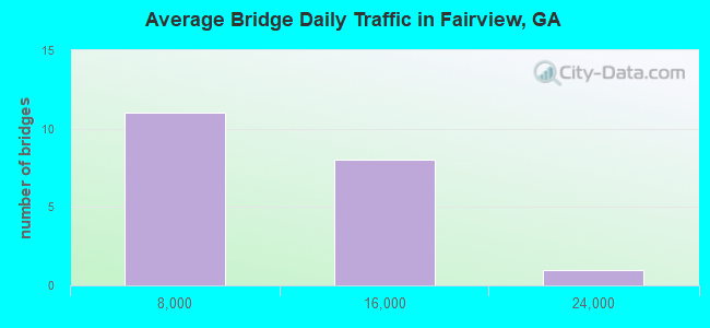
- 143,280Total average daily traffic
- 6,506Total average daily truck traffic
- National Bridge Inventory (NBI) Registered Bridges for Fairview
- No street view available for this location
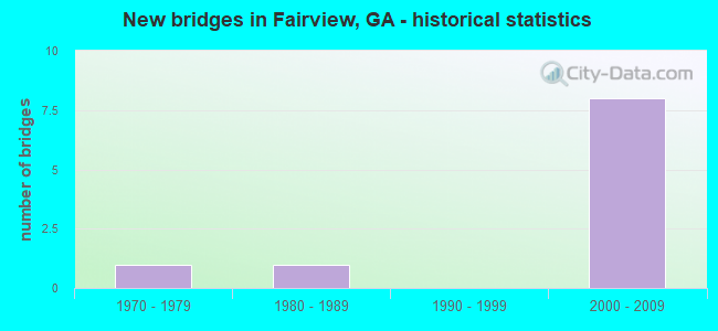
- New bridges - historical statistics
- 11970-1979
- 11980-1989
- 82000-2009
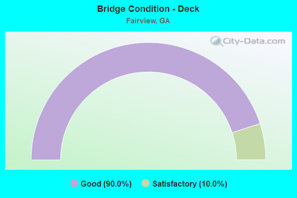
- Bridge Condition - Deck
- 90.0%Good
- 10.0%Satisfactory
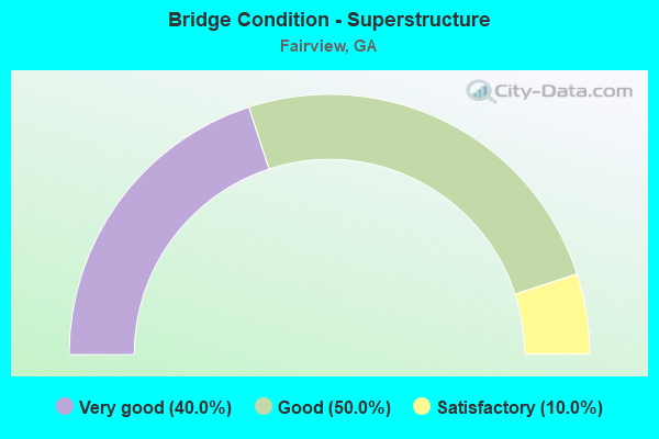
- Bridge Condition - Superstructure
- 40.0%Very good
- 50.0%Good
- 10.0%Satisfactory
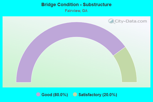
- Bridge Condition - Substructure
- 80.0%Good
- 20.0%Satisfactory
Find on map >> Show street view
Structure Number: 2950051, Location: 1.7 MI W OF FT OGLETHORPE (Lat: 34.950928, Lng: -85.297739), Route carried "on" structure: State highway 2, Year Built: 1985, Status: Open, Structure Length: 4.51m (14.80ft), Average Daily Traffic: 12,660 (year 2011), Truck Traffic: 1%, Average Future Daily Traffic: 18,990 (year 2031), Design Load: HS 20+Mod, Features Intersected: NS RAILROAD
Minimum Vertical Clearance: 30+ m (98+ ft), Kilometerpoint: 3.219, Lanes on structure: 4, Base Highway Network: Yes, Owner: State Highway Agency, Approaching Roadway Width: 18.9m (62.0ft), Skew: 3 degrees, Material/Design: Steel, Design/Construction: Stringer/Multi-beam, Number Of Spans In Main Unit: 1, Length of Maximum Span: 45.1m (148.0ft), Curb-To-Curb Width: 25.0m (82.0ft), Out-to-Out Width: 26.0m (85.3ft)
Condition: Deck: Good, Superstructure: Good, Substructure: Satisfactory, Operating Rating: 89.8 metric tons, Method Used To Determine Operating Rating: Load Factor (LF), Inventory Rating: 56.2 metric tons, Method Used To Determine Inventory Rating: Load Factor (LF), Structural Evaluation: Equal to present minimum criteria, Deck Geometry: Superior to present desirable criteria, Underclear: Superior to present desirable criteria, Approach Roadway Alignment: Equal to present desirable criteria, Designated Inspection Frequency: Every 24 months, Inspection Date: Febuary 2021, Bridge Improvement Cost: $894,000, Roadway Improvement Cost: $89,000, Total Project Cost: $1,341,000, Deck Structure Type: Concrete Cast-file-Place
Find on map >> Show street view
Structure Number: 2955071, Location: 2.3 MI S OF ROSSVILLE (Lat: 34.941139, Lng: -85.312369), Route carried "on" structure: County highway 750, Year Built: 1975, Status: Posted for load, Structure Length: 0.88m (2.89ft), Average Daily Traffic: 1,220 (year 2011), Truck Traffic: 1%, Average Future Daily Traffic: 1,830 (year 2031), Features Intersected: DRY CREEK, Facility Carried by Structure: TURNER RIDGE ROAD
Minimum Vertical Clearance: 30+ m (98+ ft), Kilometerpoint: 0.000, Lanes on structure: 2, Base Highway Network: Yes, Owner: County Highway Agency, Approaching Roadway Width: 7.0m (23.0ft), Skew: 5 degrees, Material/Design: Steel, Design/Construction: Stringer/Multi-beam, Number Of Spans In Main Unit: 1, Length of Maximum Span: 8.8m (28.9ft), Curb or Sidewalk Widths: Left: 0.3m (1.0ft), Right: 0.3m (1.0ft), Curb-To-Curb Width: 7.3m (24.0ft), Out-to-Out Width: 8.5m (27.9ft)
Condition: Deck: Satisfactory, Superstructure: Satisfactory, Substructure: Satisfactory, Channel: Very good, Operating Rating: 32.6 metric tons, Method Used To Determine Operating Rating: Load Factor (LF), Inventory Rating: 19.0 metric tons, Method Used To Determine Inventory Rating: Load Factor (LF), Structural Evaluation: Somewhat better than minimum adequacy, Deck Geometry: Meets minimum limits, Waterway Adequacy: Superior to present desirable criteria, Approach Roadway Alignment: Somewhat better than minimum adequacy, Bridge Posting: Required (Relationship of Operating Rating to Maximum Legal Load: 10.0 - 19.9% below), Designated Inspection Frequency: Every 24 months, Inspection Date: Febuary 2021, Bridge Improvement Cost: $113,000, Roadway Improvement Cost: $11,000, Total Project Cost: $170,000, Deck Structure Type: Concrete Cast-file-Place, Wearing Surface/Protective System: Wearing Surface: Bituminous
Find on map >> Show street view
Structure Number: 2955097, Location: 3 MI N OF CHICKAMAUGA (Lat: 34.924950, Lng: -85.282139), Route carried "on" structure: US 27, Year Built: 2001, Status: Open, Structure Length: 15.30m (50.20ft), Average Daily Traffic: 13,530 (year 2011), Truck Traffic: 5%, Average Future Daily Traffic: 20,295 (year 2031), Design Load: HS 20+Mod, Features Intersected: WILDER RD & NOR SOU RR
Minimum Vertical Clearance: 30+ m (98+ ft), Kilometerpoint: 40.234, Lanes on structure: 2, Lanes under structure: 2, Base Highway Network: Yes, Owner: State Highway Agency, Approaching Roadway Width: 9.1m (29.9ft), Skew: 11 degrees, Material/Design: Prestressed concrete, Design/Construction: Stringer/Multi-beam, Number Of Spans In Main Unit: 6, Length of Maximum Span: 27.4m (89.9ft), Curb-To-Curb Width: 12.1m (39.7ft), Out-to-Out Width: 13.1m (43.0ft)
Condition: Deck: Good, Superstructure: Good, Substructure: Good, Operating Rating: 50.8 metric tons, Method Used To Determine Operating Rating: Allowable Stress (AS), Inventory Rating: 29.9 metric tons, Method Used To Determine Inventory Rating: Allowable Stress (AS), Structural Evaluation: Better than present minimum criteria, Deck Geometry: Better than present minimum criteria, Underclear: Equal to present minimum criteria, Approach Roadway Alignment: Equal to present desirable criteria, Designated Inspection Frequency: Every 24 months, Inspection Date: Febuary 2021, Bridge Improvement Cost: $1,961,000, Roadway Improvement Cost: $196,000, Total Project Cost: $2,942,000, Deck Structure Type: Concrete Cast-file-Place
Find on map >> Show street view
Structure Number: 2955098, Location: 3 MI N OF CHICKAMAUGA (Lat: 34.925078, Lng: -85.282378), Route carried "on" structure: US 27, Year Built: 2001, Status: Open, Structure Length: 15.30m (50.20ft), Average Daily Traffic: 13,530 (year 2011), Truck Traffic: 5%, Average Future Daily Traffic: 20,295 (year 2031), Design Load: HS 20+Mod, Features Intersected: WILDER RD & NOR SOU RR
Minimum Vertical Clearance: 30+ m (98+ ft), Kilometerpoint: 40.234, Lanes on structure: 2, Lanes under structure: 2, Base Highway Network: Yes, Owner: State Highway Agency, Approaching Roadway Width: 9.1m (29.9ft), Skew: 12 degrees, Material/Design: Prestressed concrete, Design/Construction: Stringer/Multi-beam, Number Of Spans In Main Unit: 6, Length of Maximum Span: 27.4m (89.9ft), Curb-To-Curb Width: 12.1m (39.7ft), Out-to-Out Width: 13.1m (43.0ft)
Condition: Deck: Good, Superstructure: Good, Substructure: Good, Operating Rating: 50.8 metric tons, Method Used To Determine Operating Rating: Allowable Stress (AS), Inventory Rating: 29.9 metric tons, Method Used To Determine Inventory Rating: Allowable Stress (AS), Structural Evaluation: Better than present minimum criteria, Deck Geometry: Better than present minimum criteria, Underclear: Superior to present desirable criteria, Approach Roadway Alignment: Equal to present desirable criteria, Designated Inspection Frequency: Every 24 months, Inspection Date: Febuary 2021, Bridge Improvement Cost: $1,961,000, Roadway Improvement Cost: $196,000, Total Project Cost: $2,942,000, Deck Structure Type: Concrete Cast-file-Place
Find on map >> Show street view
Structure Number: 2955099, Location: 5 MI N OF CHICKAMAUGA (Lat: 34.943208, Lng: -85.277797), Route carried "on" structure: US 27, Year Built: 2001, Status: Open, Structure Length: 4.91m (16.11ft), Average Daily Traffic: 13,530 (year 2011), Truck Traffic: 5%, Average Future Daily Traffic: 20,295 (year 2031), Design Load: HS 20+Mod, Features Intersected: McFARLAND GAP ROAD
Minimum Vertical Clearance: 30+ m (98+ ft), Kilometerpoint: 41.843, Lanes on structure: 2, Lanes under structure: 2, Base Highway Network: Yes, Owner: State Highway Agency, Approaching Roadway Width: 11.6m (38.1ft), Skew: 10 degrees, Material/Design: Prestressed concrete, Design/Construction: Box Beam or Girders - Single/Spread, Number Of Spans In Main Unit: 1, Length of Maximum Span: 49.1m (161.1ft), Curb-To-Curb Width: 12.2m (40.0ft), Out-to-Out Width: 13.2m (43.3ft)
Condition: Deck: Good, Superstructure: Good, Substructure: Good, Operating Rating: 46.2 metric tons, Method Used To Determine Operating Rating: Allowable Stress (AS), Inventory Rating: 32.6 metric tons, Method Used To Determine Inventory Rating: Allowable Stress (AS), Structural Evaluation: Better than present minimum criteria, Deck Geometry: Better than present minimum criteria, Underclear: Superior to present desirable criteria, Approach Roadway Alignment: Equal to present desirable criteria, Designated Inspection Frequency: Every 24 months, Inspection Date: Febuary 2021, Bridge Improvement Cost: $629,000, Roadway Improvement Cost: $63,000, Total Project Cost: $944,000, Deck Structure Type: Concrete Cast-file-Place
Find on map >> Show street view
Structure Number: 29551, Location: 5 MI N C HICKAMAUGA (Lat: 34.943308, Lng: -85.278000), Route carried "on" structure: US 27, Year Built: 2001, Status: Open, Structure Length: 4.82m (15.81ft), Average Daily Traffic: 13,530 (year 2011), Truck Traffic: 5%, Average Future Daily Traffic: 20,295 (year 2031), Design Load: HS 20+Mod, Features Intersected: McFARLAND GAP ROAD
Minimum Vertical Clearance: 30+ m (98+ ft), Kilometerpoint: 41.843, Lanes on structure: 3, Lanes under structure: 2, Base Highway Network: Yes, Owner: State Highway Agency, Approaching Roadway Width: 9.4m (30.8ft), Skew: 10 degrees, Material/Design: Prestressed concrete, Design/Construction: Box Beam or Girders - Single/Spread, Number Of Spans In Main Unit: 1, Length of Maximum Span: 48.2m (158.1ft), Curb-To-Curb Width: 16.2m (53.1ft), Out-to-Out Width: 17.1m (56.1ft)
Condition: Deck: Good, Superstructure: Good, Substructure: Good, Operating Rating: 46.2 metric tons, Method Used To Determine Operating Rating: Allowable Stress (AS), Inventory Rating: 32.6 metric tons, Method Used To Determine Inventory Rating: Allowable Stress (AS), Structural Evaluation: Better than present minimum criteria, Deck Geometry: Better than present minimum criteria, Underclear: Superior to present desirable criteria, Approach Roadway Alignment: Equal to present desirable criteria, Designated Inspection Frequency: Every 24 months, Inspection Date: Febuary 2021, Bridge Improvement Cost: $786,000, Roadway Improvement Cost: $79,000, Total Project Cost: $1,179,000, Deck Structure Type: Concrete Cast-file-Place
Find on map >> Show street view
Structure Number: 2955102, Location: 5.5 MI N OF CHICKAMUAGA (Lat: 34.947458, Lng: -85.275589), Route carried "on" structure: US 27, Year Built: 2001, Status: Open, Structure Length: 3.75m (12.30ft), Average Daily Traffic: 13,530 (year 2011), Truck Traffic: 5%, Average Future Daily Traffic: 20,295 (year 2031), Design Load: HS 20+Mod, Features Intersected: LITTLE STREET (CR 297)
Minimum Vertical Clearance: 30+ m (98+ ft), Kilometerpoint: 41.843, Lanes on structure: 3, Lanes under structure: 2, Base Highway Network: Yes, Owner: State Highway Agency, Approaching Roadway Width: 12.8m (42.0ft), Skew: 11 degrees, Material/Design: Prestressed concrete, Design/Construction: Stringer/Multi-beam, Number Of Spans In Main Unit: 1, Length of Maximum Span: 37.5m (123.0ft), Curb-To-Curb Width: 18.7m (61.4ft), Out-to-Out Width: 19.8m (65.0ft)
Condition: Deck: Good, Superstructure: Very good, Substructure: Good, Operating Rating: 82.5 metric tons, Method Used To Determine Operating Rating: Load Factor (LF), Inventory Rating: 33.5 metric tons, Method Used To Determine Inventory Rating: Load Factor (LF), Structural Evaluation: Better than present minimum criteria, Deck Geometry: Superior to present desirable criteria, Underclear: Better than present minimum criteria, Approach Roadway Alignment: Equal to present desirable criteria, Designated Inspection Frequency: Every 24 months, Inspection Date: Febuary 2021, Bridge Improvement Cost: $612,000, Roadway Improvement Cost: $61,000, Total Project Cost: $917,000, Deck Structure Type: Concrete Cast-file-Place
Find on map >> Show street view
Structure Number: 2955103, Location: SR 2 RAMP TO US 27 SBL (Lat: 34.950469, Lng: -85.276061), Route carried "on" structure: Ramp State highway 2, Year Built: 2001, Status: Open, Structure Length: 5.00m (16.40ft), Average Daily Traffic: 1,520 (year 2011), Truck Traffic: 1%, Average Future Daily Traffic: 2,280 (year 2031), Design Load: HS 20+Mod, Features Intersected: DEWBERRY ROAD
Minimum Vertical Clearance: 30+ m (98+ ft), Kilometerpoint: 6.437, Lanes on structure: 1, Lanes under structure: 2, Base Highway Network: Yes, Owner: State Highway Agency, Approaching Roadway Width: 6.7m (22.0ft), Skew: 2 degrees, Material/Design: Prestressed concrete, Design/Construction: Stringer/Multi-beam, Number Of Spans In Main Unit: 3, Length of Maximum Span: 19.8m (65.0ft), Curb-To-Curb Width: 9.1m (29.9ft), Out-to-Out Width: 10.2m (33.5ft)
Condition: Deck: Good, Superstructure: Very good, Substructure: Good, Operating Rating: 35.3 metric tons, Method Used To Determine Operating Rating: Load Factor (LF), Inventory Rating: 20.8 metric tons, Method Used To Determine Inventory Rating: Load Factor (LF), Structural Evaluation: Somewhat better than minimum adequacy, Deck Geometry: Superior to present desirable criteria, Underclear: Superior to present desirable criteria, Approach Roadway Alignment: Equal to present minimum criteria, Designated Inspection Frequency: Every 24 months, Inspection Date: Febuary 2021, Bridge Improvement Cost: $466,000, Roadway Improvement Cost: $47,000, Total Project Cost: $699,000, Deck Structure Type: Concrete Cast-file-Place
Find on map >> Show street view
Structure Number: 2955104, Location: 6.5 MI N OF CHICKAMAUGA (Lat: 34.951439, Lng: -85.273439), Route carried "on" structure: US 27, Year Built: 2001, Status: Open, Structure Length: 10.18m (33.40ft), Average Daily Traffic: 1,430 (year 2011), Truck Traffic: 1%, Average Future Daily Traffic: 2,145 (year 2031), Design Load: HS 20+Mod, Features Intersected: SR 2
Minimum Vertical Clearance: 30+ m (98+ ft), Kilometerpoint: 43.452, Lanes on structure: 1, Lanes under structure: 4, Base Highway Network: Yes, Owner: State Highway Agency, Approaching Roadway Width: 6.7m (22.0ft), Skew: 13 degrees, Material/Design: Prestressed concrete, Design/Construction: Stringer/Multi-beam, Number Of Spans In Main Unit: 4, Length of Maximum Span: 29.0m (95.1ft), Curb-To-Curb Width: 9.1m (29.9ft), Out-to-Out Width: 9.8m (32.2ft)
Condition: Deck: Good, Superstructure: Very good, Substructure: Good, Operating Rating: 48.0 metric tons, Method Used To Determine Operating Rating: Load Factor (LF), Inventory Rating: 25.4 metric tons, Method Used To Determine Inventory Rating: Load Factor (LF), Structural Evaluation: Equal to present minimum criteria, Deck Geometry: Somewhat better than minimum adequacy, Underclear: Better than present minimum criteria, Approach Roadway Alignment: Equal to present desirable criteria, Designated Inspection Frequency: Every 24 months, Inspection Date: Febuary 2021, Bridge Improvement Cost: $949,000, Roadway Improvement Cost: $95,000, Total Project Cost: $1,424,000, Deck Structure Type: Concrete Cast-file-Place
Find on map >> Show street view
Structure Number: 2955105, Location: 6.5 MI N OF CHICKAMAUGA (Lat: 34.951378, Lng: -85.273700), Route carried "on" structure: US 27, Year Built: 2001, Status: Open, Structure Length: 10.21m (33.50ft), Average Daily Traffic: 23,340 (year 2011), Truck Traffic: 1%, Average Future Daily Traffic: 35,010 (year 2031), Design Load: HS 20+Mod, Features Intersected: SR 2
Minimum Vertical Clearance: 30+ m (98+ ft), Kilometerpoint: 43.452, Lanes on structure: 2, Lanes under structure: 4, Base Highway Network: Yes, Owner: State Highway Agency, Approaching Roadway Width: 8.8m (28.9ft), Skew: 14 degrees, Material/Design: Prestressed concrete, Design/Construction: Stringer/Multi-beam, Number Of Spans In Main Unit: 4, Length of Maximum Span: 29.3m (96.1ft), Curb-To-Curb Width: 12.2m (40.0ft), Out-to-Out Width: 13.1m (43.0ft)
Condition: Deck: Good, Superstructure: Very good, Substructure: Good, Operating Rating: 56.2 metric tons, Method Used To Determine Operating Rating: Load Factor (LF), Inventory Rating: 29.0 metric tons, Method Used To Determine Inventory Rating: Load Factor (LF), Structural Evaluation: Better than present minimum criteria, Deck Geometry: Better than present minimum criteria, Underclear: Better than present minimum criteria, Approach Roadway Alignment: Equal to present desirable criteria, Designated Inspection Frequency: Every 24 months, Inspection Date: Febuary 2021, Bridge Improvement Cost: $1,309,000, Roadway Improvement Cost: $131,000, Total Project Cost: $1,963,000, Deck Structure Type: Concrete Cast-file-Place
Find on map >> Show street view
Structure Number: 2950049, Location: 1.7 MI W OF FT OGLETHORPE (Lat: 34.948278, Lng: -85.294369), Route carried "under" structure: County highway 834, Structure Length: 0. m, Average Daily Traffic: 1,560 (year 2011), Truck Traffic: 1%, Features Intersected: CR 834 McFARLAND AVE., Facility Carried by Structure: CHATT & CHICK SL (
Minimum Vertical Clearance: 5.89m (19.32ft), Kilometerpoint: 0.000, Length of Maximum Span: 0.0m
Find on map >> Show street view
Structure Number: 2955097, Location: 3 MI N OF CHICKAMAUGA (Lat: 34.924950, Lng: -85.282139), Route carried "under" structure: County highway 1106, Structure Length: 0. m, Average Daily Traffic: 300 (year 2001), Features Intersected: SR 1 NBL (US 27), Facility Carried by Structure: SR 1 - US 27 (NBL)
Minimum Vertical Clearance: 12.34m (40.49ft), Kilometerpoint: 6.437, Lanes on structure: 2, Length of Maximum Span: 0.0m
Find on map >> Show street view
Structure Number: 2955098, Location: 3 MI N OF CHICKAMAUGA (Lat: 34.925078, Lng: -85.282378), Route carried "under" structure: County highway 1106, Structure Length: 0. m, Average Daily Traffic: 300 (year 2001), Features Intersected: SR 1 SBL (US 27), Facility Carried by Structure: SR 1 - US 27 (SBL)
Minimum Vertical Clearance: 12.39m (40.65ft), Kilometerpoint: 6.437, Lanes on structure: 2, Length of Maximum Span: 0.0m
Find on map >> Show street view
Structure Number: 2955099, Location: 5 MI N OF CHICKAMAUGA (Lat: 34.943208, Lng: -85.277797), Route carried "under" structure: County highway 1106, Structure Length: 0. m, Average Daily Traffic: 1,200 (year 2001), Truck Traffic: 1%, Features Intersected: SR 1 NBL (US27), Facility Carried by Structure: SR 1 - US 27 (NBL)
Minimum Vertical Clearance: 8.30m (27.23ft), Kilometerpoint: 1.609, Lanes on structure: 2, Length of Maximum Span: 0.0m
Find on map >> Show street view
Structure Number: 29551, Location: 5 MI N C HICKAMAUGA (Lat: 34.943308, Lng: -85.278000), Route carried "under" structure: County highway 1106, Structure Length: 0. m, Average Daily Traffic: 1,200 (year 2001), Truck Traffic: 1%, Features Intersected: SR 1 SBL (US 27), Facility Carried by Structure: SR 1 - US 27 (SBL)
Minimum Vertical Clearance: 8.07m (26.48ft), Kilometerpoint: 1.609, Lanes on structure: 3, Length of Maximum Span: 0.0m
Find on map >> Show street view
Structure Number: 2955101, Location: 5.5 MI N OF CHICKAMAUGA (Lat: 34.947239, Lng: -85.275389), Route carried "under" structure: County highway 297, Structure Length: 0. m, Average Daily Traffic: 300 (year 2002), Features Intersected: SR1 NBL (US 27), Facility Carried by Structure: SR 1 - US 27 (NBL)
Minimum Vertical Clearance: 4.57m (14.99ft), Kilometerpoint: 0.000, Lanes on structure: 3, Length of Maximum Span: 0.0m
Find on map >> Show street view
Structure Number: 2955102, Location: 5.5 MI N OF CHICKAMUAGA (Lat: 34.947458, Lng: -85.275589), Route carried "under" structure: County highway 297, Structure Length: 0. m, Average Daily Traffic: 300 (year 2001), Features Intersected: SR1 SBL (US 27), Facility Carried by Structure: SR 1 - US 27 (SBL)
Minimum Vertical Clearance: 5.43m (17.81ft), Kilometerpoint: 0.000, Lanes on structure: 3, Length of Maximum Span: 0.0m
Find on map >> Show street view
Structure Number: 2955103, Location: SR 2 RAMP TO US 27 SBL (Lat: 34.950469, Lng: -85.276061), Route carried "under" structure: County highway 1102, Structure Length: 0. m, Average Daily Traffic: 500 (year 2001), Truck Traffic: 1%, Features Intersected: SR 2 RMP TO US 27 SBL, Facility Carried by Structure: SR 2 OFF RAMP
Minimum Vertical Clearance: 6.19m (20.31ft), Kilometerpoint: 0.000, Lanes on structure: 1, Length of Maximum Span: 0.0m
Find on map >> Show street view
Structure Number: 2955104, Location: 6.5 MI N OF CHICKAMAUGA (Lat: 34.951439, Lng: -85.273439), Route carried "under" structure: State highway 2, Structure Length: 0. m, Average Daily Traffic: 14,900 (year 2010), Truck Traffic: 9%, Features Intersected: SR 1R T0 SR 2 WEST
Minimum Vertical Clearance: 6.19m (20.31ft), Kilometerpoint: 6.437, Lanes on structure: 1, Length of Maximum Span: 0.0m
Find on map >> Show street view
Structure Number: 2955105, Location: 6.5 MI N OF CHICKAMAUGA (Lat: 34.951378, Lng: -85.273700), Route carried "under" structure: State highway 2, Structure Length: 0. m, Average Daily Traffic: 14,900 (year 2010), Truck Traffic: 9%, Features Intersected: SR 1 SBL
Minimum Vertical Clearance: 7.06m (23.16ft), Kilometerpoint: 6.437, Lanes on structure: 2, Length of Maximum Span: 0.0m