Bridge Statistics for Fairview, Missouri (MO)
Condition, Traffic, Stress, Structural Evaluation, Project Costs
- National Bridge Inventory (NBI) Statistics
- 13Number of bridges
- 79ft / 23.6mTotal length
- $2,181,000Total costs
- 4,172Total average daily traffic
- 637Total average daily truck traffic
- 7,397Total future (year 2039) average daily traffic
- National Bridge Inventory (NBI) Registered Bridges for Fairview
- No street view available for this location
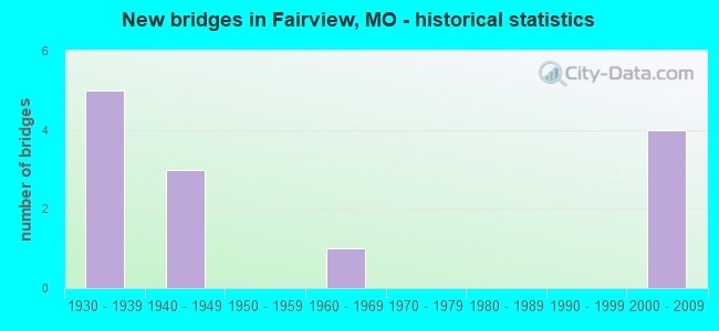
- New bridges - historical statistics
- 51930-1939
- 31940-1949
- 11960-1969
- 42000-2009


- Bridge Condition - Deck
- 30.0%Very good
- 30.0%Good
- 30.0%Satisfactory
- 10.0%Fair

- Bridge Condition - Superstructure
- 20.0%Very good
- 40.0%Good
- 30.0%Satisfactory
- 10.0%Fair

- Bridge Condition - Substructure
- 30.0%Very good
- 30.0%Good
- 20.0%Satisfactory
- 20.0%Fair

- Bridge Condition - Channel
- 7.7%Good
- 61.5%Satisfactory
- 30.8%Fair

- Bridge Condition - Culverts
- 66.7%Satisfactory
- 33.3%Fair
Find on map >> Show street view
Structure Number: 1833, Location: S 36 T 25 N R 29 W (Lat: 36.836239, Lng: -94.053867), Route carried "on" structure: County highway 182, Year Built: 1965, Year Reconstructed: 2000, Status: Open, Structure Length: 1.13m (3.71ft), Average Daily Traffic: 150 (year 2019), Truck Traffic: 10%, Average Future Daily Traffic: 255 (year 2039), Features Intersected: SHOAL CR, Facility Carried by Structure: FARM RD 2065
Minimum Vertical Clearance: 30+ m (98+ ft), Kilometerpoint: 0.161, Lanes on structure: 2, Owner: County Highway Agency, Approaching Roadway Width: 5.8m (19.0ft), Material/Design: Concrete continuous, Design/Construction: Slab, Number Of Spans In Main Unit: 2, Length of Maximum Span: 5.1m (16.7ft), Curb-To-Curb Width: 7.0m (23.0ft), Out-to-Out Width: 7.4m (24.3ft)
Condition: Deck: Satisfactory, Superstructure: Satisfactory, Substructure: Satisfactory, Channel: Fair, Operating Rating: 26.1 metric tons, Method Used To Determine Operating Rating: Load Factor (LF), Inventory Rating: 15.3 metric tons, Method Used To Determine Inventory Rating: Load Factor (LF), Structural Evaluation: Meets minimum limits, Deck Geometry: Meets minimum limits, Waterway Adequacy: Equal to present minimum criteria, Approach Roadway Alignment: Equal to present desirable criteria, Designated Inspection Frequency: Every 24 months, Inspection Date: Febuary 2022, Deck Structure Type: Concrete Cast-file-Place, Wearing Surface/Protective System: Wearing Surface: Monolithic Concrete
Find on map >> Show street view
Structure Number: 25063, Location: S 10 T 24 N R 30 W (Lat: 36.811458, Lng: -94.145475), Route carried "on" structure: County highway 611, Year Built: 1930, Status: Posted for load, Structure Length: 2.44m (8.01ft), Average Daily Traffic: 60 (year 2021), Truck Traffic: 10%, Average Future Daily Traffic: 93 (year 2041), Design Load: H 15, Features Intersected: MID INDIAN CR, Facility Carried by Structure: UNICORN RD
Minimum Vertical Clearance: 30+ m (98+ ft), Kilometerpoint: 1.287, Lanes on structure: 2, Owner: County Highway Agency, Approaching Roadway Width: 5.5m (18.0ft), Material/Design: Concrete, Design/Construction: Slab, Number Of Spans In Main Unit: 4, Length of Maximum Span: 6.1m (20.0ft), Curb-To-Curb Width: 6.1m (20.0ft), Out-to-Out Width: 6.7m (22.0ft)
Condition: Deck: Satisfactory, Superstructure: Satisfactory, Substructure: Fair, Channel: Fair, Operating Rating: 10.8 metric tons, Method Used To Determine Operating Rating: Field evaluation and documented engineering judgment, Inventory Rating: 6.3 metric tons, Method Used To Determine Inventory Rating: Field evaluation and documented engineering judgment, Structural Evaluation: High priority of replacement, Deck Geometry: Somewhat better than minimum adequacy, Waterway Adequacy: Better than present minimum criteria, Approach Roadway Alignment: Equal to present desirable criteria, Bridge Posting: Required (Relationship of Operating Rating to Maximum Legal Load: > 39.9% below), Length Of Structure Improvement: 0.33m (1.08ft), Designated Inspection Frequency: Every 24 months, Inspection Date: January 2020, Bridge Improvement Cost: $240,000, Roadway Improvement Cost: $24,000, Total Project Cost: $360,000 ( Estimate for 2022), Deck Structure Type: Concrete Cast-file-Place, Wearing Surface/Protective System: Wearing Surface: Bituminous
Find on map >> Show street view
Structure Number: 25064, Location: S 14 T 24 N R 30 W (Lat: 36.803208, Lng: -94.145808), Route carried "on" structure: County highway 611, Year Built: 1940, Status: Posted for load, Structure Length: 1.28m (4.20ft), Average Daily Traffic: 100 (year 2021), Truck Traffic: 10%, Average Future Daily Traffic: 155 (year 2041), Design Load: H 15, Features Intersected: STEDMAN BR, Facility Carried by Structure: UNICORN RD
Minimum Vertical Clearance: 30+ m (98+ ft), Kilometerpoint: 2.092, Lanes on structure: 2, Owner: County Highway Agency, Approaching Roadway Width: 5.5m (18.0ft), Material/Design: Concrete continuous, Design/Construction: Culvert, Number Of Spans In Main Unit: 3, Length of Maximum Span: 4.3m (14.1ft), Curb-To-Curb Width: 7.3m (24.0ft), Out-to-Out Width: 7.9m (25.9ft)
Condition: Channel: Satisfactory, Culverts: Satisfactory, Operating Rating: 31.5 metric tons, Method Used To Determine Operating Rating: Allowable Stress (AS), Inventory Rating: 17.1 metric tons, Method Used To Determine Inventory Rating: Allowable Stress (AS), Structural Evaluation: Somewhat better than minimum adequacy, Deck Geometry: Equal to present minimum criteria, Waterway Adequacy: Better than present minimum criteria, Approach Roadway Alignment: Equal to present desirable criteria, Designated Inspection Frequency: Every 24 months, Inspection Date: January 2020
Find on map >> Show street view
Structure Number: 25099, Location: S 7 T 24 N R 29 W (Lat: 36.807231, Lng: -94.093275), Route carried "on" structure: County highway 625, Year Built: 1940, Status: Posted for load, Structure Length: 0.85m (2.79ft), Average Daily Traffic: 100 (year 2021), Truck Traffic: 10%, Average Future Daily Traffic: 155 (year 2041), Design Load: H 10, Features Intersected: TRIB MID INDIAN CR, Facility Carried by Structure: S LINEBARGER RD
Minimum Vertical Clearance: 30+ m (98+ ft), Kilometerpoint: 1.448, Lanes on structure: 2, Owner: County Highway Agency, Approaching Roadway Width: 6.1m (20.0ft), Material/Design: Concrete continuous, Design/Construction: Slab, Number Of Spans In Main Unit: 2, Length of Maximum Span: 4.0m (13.1ft), Curb-To-Curb Width: 5.6m (18.4ft), Out-to-Out Width: 6.1m (20.0ft)
Condition: Deck: Good, Superstructure: Good, Substructure: Good, Channel: Satisfactory, Operating Rating: 31.5 metric tons, Method Used To Determine Operating Rating: Allowable Stress (AS), Inventory Rating: 17.1 metric tons, Method Used To Determine Inventory Rating: Allowable Stress (AS), Structural Evaluation: Somewhat better than minimum adequacy, Deck Geometry: Meets minimum limits, Waterway Adequacy: Better than present minimum criteria, Approach Roadway Alignment: Somewhat better than minimum adequacy, Designated Inspection Frequency: Every 24 months, Inspection Date: January 2020, Deck Structure Type: Concrete Cast-file-Place, Wearing Surface/Protective System: Wearing Surface: Bituminous
Find on map >> Show street view
Structure Number: 25166, Location: S 7 T 24 N R 29 W (Lat: 36.807006, Lng: -94.101817), Route carried "on" structure: County highway 650, Year Built: 1935, Status: Posted for load, Structure Length: 0.67m (2.20ft), Average Daily Traffic: 60 (year 2021), Truck Traffic: 10%, Average Future Daily Traffic: 93 (year 2041), Design Load: H 10, Features Intersected: MID INDIAN CR, Facility Carried by Structure: PALM RD
Minimum Vertical Clearance: 30+ m (98+ ft), Kilometerpoint: 4.023, Lanes on structure: 2, Owner: County Highway Agency, Approaching Roadway Width: 6.1m (20.0ft), Material/Design: Concrete continuous, Design/Construction: Slab, Number Of Spans In Main Unit: 2, Length of Maximum Span: 3.4m (11.2ft), Curb-To-Curb Width: 7.3m (24.0ft), Out-to-Out Width: 7.9m (25.9ft)
Condition: Deck: Good, Superstructure: Good, Substructure: Good, Channel: Satisfactory, Operating Rating: 31.5 metric tons, Method Used To Determine Operating Rating: Allowable Stress (AS), Inventory Rating: 17.1 metric tons, Method Used To Determine Inventory Rating: Allowable Stress (AS), Structural Evaluation: Somewhat better than minimum adequacy, Deck Geometry: Equal to present minimum criteria, Waterway Adequacy: Better than present minimum criteria, Approach Roadway Alignment: Equal to present desirable criteria, Designated Inspection Frequency: Every 24 months, Inspection Date: January 2020, Deck Structure Type: Concrete Cast-file-Place, Wearing Surface/Protective System: Wearing Surface: Gravel
Find on map >> Show street view
Structure Number: 25167, Location: S 8 T 24 N R 29 W (Lat: 36.806756, Lng: -94.093131), Route carried "on" structure: County highway 650, Year Built: 1940, Status: Posted for load, Structure Length: 0.67m (2.20ft), Average Daily Traffic: 50 (year 2021), Truck Traffic: 10%, Average Future Daily Traffic: 78 (year 2041), Design Load: H 10, Features Intersected: TRIB MID INDIAN CR, Facility Carried by Structure: PALM RD
Minimum Vertical Clearance: 30+ m (98+ ft), Kilometerpoint: 4.989, Lanes on structure: 2, Owner: County Highway Agency, Approaching Roadway Width: 5.8m (19.0ft), Material/Design: Concrete continuous, Design/Construction: Culvert, Number Of Spans In Main Unit: 2, Length of Maximum Span: 3.4m (11.2ft), Curb-To-Curb Width: 5.6m (18.4ft), Out-to-Out Width: 6.1m (20.0ft)
Condition: Channel: Satisfactory, Culverts: Fair, Operating Rating: 31.5 metric tons, Method Used To Determine Operating Rating: Allowable Stress (AS), Inventory Rating: 17.1 metric tons, Method Used To Determine Inventory Rating: Allowable Stress (AS), Structural Evaluation: Somewhat better than minimum adequacy, Deck Geometry: Meets minimum limits, Waterway Adequacy: Better than present minimum criteria, Approach Roadway Alignment: Equal to present desirable criteria, Designated Inspection Frequency: Every 24 months, Inspection Date: January 2020, Deck Structure Type: Concrete Cast-file-Place, Wearing Surface/Protective System: Wearing Surface: Monolithic Concrete
Find on map >> Show street view
Structure Number: 25172, Location: S 14 T 24 N R 30 W (Lat: 36.793531, Lng: -94.129944), Route carried "on" structure: County highway 654, Year Built: 1935, Status: Posted for load, Structure Length: 0.79m (2.59ft), Average Daily Traffic: 40 (year 2021), Truck Traffic: 10%, Average Future Daily Traffic: 62 (year 2041), Design Load: H 10, Features Intersected: STEDMAN BR, Facility Carried by Structure: QUINCE RD
Minimum Vertical Clearance: 30+ m (98+ ft), Kilometerpoint: 1.448, Lanes on structure: 2, Owner: County Highway Agency, Approaching Roadway Width: 5.5m (18.0ft), Material/Design: Concrete, Design/Construction: Slab, Number Of Spans In Main Unit: 2, Length of Maximum Span: 3.7m (12.1ft), Curb-To-Curb Width: 6.1m (20.0ft), Out-to-Out Width: 6.6m (21.7ft)
Condition: Deck: Satisfactory, Superstructure: Satisfactory, Substructure: Satisfactory, Channel: Satisfactory, Operating Rating: 27.0 metric tons, Method Used To Determine Operating Rating: Allowable Stress (AS), Inventory Rating: 16.2 metric tons, Method Used To Determine Inventory Rating: Allowable Stress (AS), Structural Evaluation: Somewhat better than minimum adequacy, Deck Geometry: Somewhat better than minimum adequacy, Waterway Adequacy: Better than present minimum criteria, Approach Roadway Alignment: Equal to present desirable criteria, Designated Inspection Frequency: Every 24 months, Inspection Date: January 2020, Deck Structure Type: Concrete Cast-file-Place, Wearing Surface/Protective System: Wearing Surface: Gravel
Find on map >> Show street view
Structure Number: 30226, Location: S 31 T 25 N R 30 W (Lat: 36.839194, Lng: -94.138703), Route carried "on" structure: County highway , Year Built: 2003, Status: Open, Structure Length: 1.86m (6.10ft), Average Daily Traffic: 40 (year 2021), Truck Traffic: 5%, Average Future Daily Traffic: 62 (year 2041), Features Intersected: HUFFMAN BR, Facility Carried by Structure: UNICORN RD
Minimum Vertical Clearance: 30+ m (98+ ft), Kilometerpoint: 0.000, Lanes on structure: 2, Owner: County Highway Agency, Approaching Roadway Width: 7.0m (23.0ft), Material/Design: Steel, Design/Construction: Stringer/Multi-beam, Number Of Spans In Main Unit: 1, Length of Maximum Span: 18.0m (59.1ft), Curb-To-Curb Width: 7.3m (24.0ft), Out-to-Out Width: 7.5m (24.6ft)
Condition: Deck: Very good, Superstructure: Very good, Substructure: Good, Channel: Fair, Operating Rating: 29.7 metric tons, Method Used To Determine Operating Rating: Load Factor (LF), Inventory Rating: 18.0 metric tons, Method Used To Determine Inventory Rating: Load Factor (LF), Structural Evaluation: Somewhat better than minimum adequacy, Deck Geometry: Equal to present minimum criteria, Waterway Adequacy: Equal to present minimum criteria, Approach Roadway Alignment: Equal to present desirable criteria, Designated Inspection Frequency: Every 24 months, Inspection Date: January 2020, Deck Structure Type: Concrete Cast-file-Place, Wearing Surface/Protective System: Wearing Surface: Monolithic Concrete
Find on map >> Show street view
Structure Number: 3025, Location: S 20 T 24 N R 29 W (Lat: 36.787050, Lng: -94.094036), Route carried "on" structure: County highway , Year Built: 2001, Status: Open, Structure Length: 1.58m (5.18ft), Average Daily Traffic: 100 (year 2021), Truck Traffic: 5%, Average Future Daily Traffic: 155 (year 2041), Features Intersected: TRIB MID INDIAN CR, Facility Carried by Structure: WALLABY RD
Minimum Vertical Clearance: 30+ m (98+ ft), Kilometerpoint: 0.000, Lanes on structure: 2, Owner: County Highway Agency, Approaching Roadway Width: 5.8m (19.0ft), Skew: 4 degrees, Material/Design: Steel, Design/Construction: Stringer/Multi-beam, Number Of Spans In Main Unit: 1, Length of Maximum Span: 15.2m (49.9ft), Curb-To-Curb Width: 6.1m (20.0ft), Out-to-Out Width: 6.2m (20.3ft)
Condition: Deck: Very good, Superstructure: Good, Substructure: Very good, Channel: Good, Operating Rating: 76.5 metric tons, Method Used To Determine Operating Rating: Load Factor (LF), Inventory Rating: 45.9 metric tons, Method Used To Determine Inventory Rating: Load Factor (LF), Structural Evaluation: Better than present minimum criteria, Deck Geometry: Somewhat better than minimum adequacy, Waterway Adequacy: Better than present minimum criteria, Approach Roadway Alignment: Equal to present desirable criteria, Designated Inspection Frequency: Every 24 months, Inspection Date: January 2020, Deck Structure Type: Concrete Cast-file-Place, Wearing Surface/Protective System: Wearing Surface: Bituminous
Find on map >> Show street view
Structure Number: 31499, Location: S 10 T 24 N R 30 W (Lat: 36.808072, Lng: -94.150872), Route carried "on" structure: County highway 649, Year Built: 2005, Status: Open, Structure Length: 2.50m (8.20ft), Average Daily Traffic: 15 (year 2021), Truck Traffic: 10%, Average Future Daily Traffic: 23 (year 2041), Features Intersected: MID INDIAN CR, Facility Carried by Structure: PALM RD
Minimum Vertical Clearance: 30+ m (98+ ft), Kilometerpoint: 1.287, Lanes on structure: 2, Owner: County Highway Agency, Approaching Roadway Width: 3.7m (12.1ft), Skew: 4 degrees, Material/Design: Steel, Design/Construction: Stringer/Multi-beam, Number Of Spans In Main Unit: 1, Length of Maximum Span: 24.1m (79.1ft), Curb-To-Curb Width: 6.1m (20.0ft), Out-to-Out Width: 6.2m (20.3ft)
Condition: Deck: Very good, Superstructure: Good, Substructure: Very good, Channel: Satisfactory, Operating Rating: 51.3 metric tons, Method Used To Determine Operating Rating: Load Factor (LF), Inventory Rating: 30.6 metric tons, Method Used To Determine Inventory Rating: Load Factor (LF), Structural Evaluation: Better than present minimum criteria, Deck Geometry: Somewhat better than minimum adequacy, Waterway Adequacy: Better than present minimum criteria, Approach Roadway Alignment: Equal to present desirable criteria, Designated Inspection Frequency: Every 24 months, Inspection Date: January 2020, Deck Structure Type: Concrete Cast-file-Place, Wearing Surface/Protective System: Wearing Surface: Monolithic Concrete
Find on map >> Show street view
Structure Number: 3246, Location: S 12 T 24 N R 30 W (Lat: 36.817778, Lng: -94.109000), Route carried "on" structure: County highway 620, Year Built: 2004, Status: Open, Structure Length: 1.78m (5.84ft), Average Daily Traffic: 40 (year 2021), Truck Traffic: 10%, Average Future Daily Traffic: 62 (year 2041), Design Load: HS 20, Features Intersected: MID INDIAN CR, Facility Carried by Structure: WALLEYE RD
Minimum Vertical Clearance: 30+ m (98+ ft), Kilometerpoint: 0.483, Lanes on structure: 2, Owner: County Highway Agency, Approaching Roadway Width: 7.3m (24.0ft), Skew: 2 degrees, Material/Design: Steel, Design/Construction: Stringer/Multi-beam, Number Of Spans In Main Unit: 1, Length of Maximum Span: 16.8m (55.1ft), Curb-To-Curb Width: 7.3m (24.0ft), Out-to-Out Width: 8.1m (26.6ft)
Condition: Deck: Good, Superstructure: Very good, Substructure: Very good, Channel: Satisfactory, Operating Rating: 69.3 metric tons, Method Used To Determine Operating Rating: Load Factor (LF), Inventory Rating: 41.4 metric tons, Method Used To Determine Inventory Rating: Load Factor (LF), Structural Evaluation: Equal to present desirable criteria, Deck Geometry: Equal to present minimum criteria, Waterway Adequacy: Better than present minimum criteria, Approach Roadway Alignment: Equal to present desirable criteria, Designated Inspection Frequency: Every 24 months, Inspection Date: January 2020, Deck Structure Type: Concrete Cast-file-Place, Wearing Surface/Protective System: Wearing Surface: Monolithic Concrete, Deck Protection: Epoxy Coated Reinforcing
Find on map >> Show street view
Structure Number: 8581, Location: S 6 T 24 N R 29 W (Lat: 36.828975, Lng: -94.098183), Route carried "on" structure: State highway 86, Year Built: 1930, Status: Open, Structure Length: 0.82m (2.69ft), Average Daily Traffic: 1,618 (year 2021), Truck Traffic: 23%, Average Future Daily Traffic: 3,236 (year 2041), Design Load: H 10, Features Intersected: DRY BR
Minimum Vertical Clearance: 30+ m (98+ ft), Kilometerpoint: 61.463, Lanes on structure: 2, Base Highway Network: Yes, Owner: State Highway Agency, Approaching Roadway Width: 7.3m (24.0ft), Skew: 2 degrees, Material/Design: Concrete continuous, Design/Construction: Culvert, Number Of Spans In Main Unit: 3, Length of Maximum Span: 2.4m (7.9ft), Curb-To-Curb Width: 6.1m (20.0ft), Out-to-Out Width: 6.7m (22.0ft)
Condition: Channel: Satisfactory, Culverts: Satisfactory, Operating Rating: 43.2 metric tons, Method Used To Determine Operating Rating: Load Factor (LF), Inventory Rating: 26.1 metric tons, Method Used To Determine Inventory Rating: Load Factor (LF), Structural Evaluation: Equal to present minimum criteria, Deck Geometry: High priority of replacement, Waterway Adequacy: Equal to present desirable criteria, Approach Roadway Alignment: Equal to present minimum criteria, Length Of Structure Improvement: 0.15m (0.49ft), Designated Inspection Frequency: Every 24 months, Inspection Date: Febuary 2022, Bridge Improvement Cost: $170,000, Roadway Improvement Cost: $17,000, Total Project Cost: $255,000 ( Estimate for 2022)
Find on map >> Show street view
Structure Number: 9493, Location: S 10 T 24 N R 29 W (Lat: 36.819433, Lng: -94.049519), Route carried "on" structure: State highway 97, Year Built: 1936, Status: Open, Structure Length: 7.25m (23.79ft), Average Daily Traffic: 1,799 (year 2021), Truck Traffic: 11%, Average Future Daily Traffic: 2,968 (year 2041), Design Load: H 10, Features Intersected: SHOAL CR
Minimum Vertical Clearance: 30+ m (98+ ft), Kilometerpoint: 122.967, Lanes on structure: 2, Owner: State Highway Agency, Approaching Roadway Width: 6.4m (21.0ft), Skew: 2 degrees, Material/Design: Concrete, Design/Construction: Tee Beam, Number Of Spans In Main Unit: 5, Length of Maximum Span: 14.5m (47.6ft), Curb-To-Curb Width: 6.1m (20.0ft), Out-to-Out Width: 7.0m (23.0ft)
Condition: Deck: Fair, Superstructure: Fair, Substructure: Fair, Channel: Fair, Operating Rating: 28.8 metric tons, Method Used To Determine Operating Rating: Load Factor (LF), Inventory Rating: 17.1 metric tons, Method Used To Determine Inventory Rating: Load Factor (LF), Structural Evaluation: Meets minimum limits, Deck Geometry: High priority of replacement, Waterway Adequacy: Equal to present minimum criteria, Approach Roadway Alignment: Equal to present minimum criteria, Length Of Structure Improvement: 0.83m (2.72ft), Designated Inspection Frequency: Every 24 months, Inspection Date: September 2021, Bridge Improvement Cost: $1,044,000, Roadway Improvement Cost: $104,000, Total Project Cost: $1,566,000 ( Estimate for 2022), Deck Structure Type: Concrete Cast-file-Place, Wearing Surface/Protective System: Wearing Surface: Bituminous