Bridge Statistics for Fairview, Oregon (OR)
Condition, Traffic, Stress, Structural Evaluation, Project Costs
- National Bridge Inventory (NBI) Statistics
- 10Number of bridges
- 72ft / 22.2mTotal length
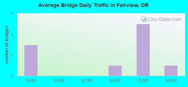
- 458,375Total average daily traffic
- 72,210Total average daily truck traffic
- National Bridge Inventory (NBI) Registered Bridges for Fairview
- No street view available for this location
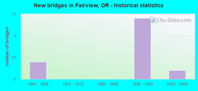
- New bridges - historical statistics
- 21960-1969
- 71990-1999
- 12000-2009
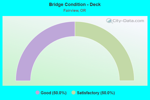
- Bridge Condition - Deck
- 50.0%Good
- 50.0%Satisfactory

- Bridge Condition - Superstructure
- 66.7%Good
- 33.3%Satisfactory
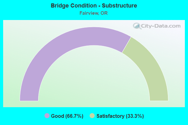
- Bridge Condition - Substructure
- 66.7%Good
- 33.3%Satisfactory
Find on map >> Show street view
Structure Number: 9321 000 01271, Location: 025 MI N FAIRVIEW (Lat: 45.557389, Lng: -122.435700), Route carried "on" structure: Bypass County highway A662, Year Built: 1964, Status: Open, Structure Length: 3.66m (12.01ft), Average Daily Traffic: 10,242 (year 2020), Truck Traffic: 10%, Average Future Daily Traffic: 10,992 (year 2025), Design Load: H 20, Features Intersected: NE 223RD AVE
Minimum Vertical Clearance: 30+ m (98+ ft), Kilometerpoint: 20.455, Lanes on structure: 2, Lanes under structure: 2, Owner: County Highway Agency, Approaching Roadway Width: 11.9m (39.0ft), Material/Design: Prestressed concrete, Design/Construction: Stringer/Multi-beam, Number Of Spans In Main Unit: 3, Length of Maximum Span: 12.2m (40.0ft), Curb or Sidewalk Widths: Left: 1.2m (3.9ft), Right: 1.2m (3.9ft), Curb-To-Curb Width: 18.3m (60.0ft), Out-to-Out Width: 21.3m (69.9ft)
Condition: Deck: Satisfactory, Superstructure: Good, Substructure: Good, Operating Rating: 32.7 metric tons, Method Used To Determine Operating Rating: Load Factor (LF), Inventory Rating: 20.0 metric tons, Method Used To Determine Inventory Rating: Load Factor (LF), Structural Evaluation: Somewhat better than minimum adequacy, Deck Geometry: Superior to present desirable criteria, Underclear: Meets minimum limits, Approach Roadway Alignment: Equal to present desirable criteria, Designated Inspection Frequency: Every 24 months, Inspection Date: July 2020, Deck Structure Type: Concrete Cast-file-Place, Wearing Surface/Protective System: Wearing Surface: Monolithic Concrete
Find on map >> Show street view
Structure Number: 17208 002 01443, Location: 3.25 M. W. OF SANDY RIVER (Lat: 45.539339, Lng: -122.449111), Route carried "on" structure: City street , Year Built: 1996, Status: Open, Structure Length: 7.01m (23.00ft), Average Daily Traffic: 62,086 (year 2020), Truck Traffic: 18%, Average Future Daily Traffic: 86,100 (year 2040), Design Load: HS 25 or greater, Features Intersected: Hwy 002, Facility Carried by Structure: 207th Ave
Minimum Vertical Clearance: 30+ m (98+ ft), Kilometerpoint: 23.223, Lanes on structure: 4, Lanes under structure: 7, Base Highway Network: Yes, Owner: State Highway Agency, Approaching Roadway Width: 22.6m (74.1ft), Skew: 1 degrees, Material/Design: Prestressed concrete continuous, Design/Construction: Box Beam or Girders - Multiple, Number Of Spans In Main Unit: 2, Length of Maximum Span: 38.1m (125.0ft), Curb or Sidewalk Widths: Left: 1.8m (5.9ft), Right: 1.8m (5.9ft), Curb-To-Curb Width: 22.6m (74.1ft), Out-to-Out Width: 27.2m (89.2ft)
Condition: Deck: Good, Superstructure: Good, Substructure: Good, Operating Rating: 31.8 metric tons, Method Used To Determine Operating Rating: Load and Resistance Factor Rating (LRFR) rating reported by rating factor(RF) method using HL-93 loadings, Inventory Rating: 24.6 metric tons, Method Used To Determine Inventory Rating: Load and Resistance Factor Rating (LRFR) rating reported by rating factor(RF) method using HL-93 loadings, Structural Evaluation: Equal to present minimum criteria, Deck Geometry: Superior to present desirable criteria, Underclear: Equal to present minimum criteria, Approach Roadway Alignment: Equal to present desirable criteria, Designated Inspection Frequency: Every 24 months, Inspection Date: April 2021, Deck Structure Type: Concrete Cast-file-Place, Wearing Surface/Protective System: Wearing Surface: Monolithic Concrete, Deck Protection: Epoxy Coated Reinforcing
Find on map >> Show street view
Structure Number: 17211, Location: 207TH INTCH,I-84 MP 14.4 (Lat: 45.538539, Lng: -122.448789), Route carried "on" structure: City street , Year Built: 1996, Status: Open, Structure Length: 2.13m (6.99ft), Average Daily Traffic: 62,086 (year 2020), Truck Traffic: 18%, Average Future Daily Traffic: 86,100 (year 2040), Design Load: HS 25 or greater, Features Intersected: RAILROAD, Facility Carried by Structure: NE 207TH AVE
Minimum Vertical Clearance: 30+ m (98+ ft), Kilometerpoint: 23.126, Lanes on structure: 4, Base Highway Network: Yes, Owner: County Highway Agency, Approaching Roadway Width: 22.6m (74.1ft), Skew: 1 degrees, Material/Design: Prestressed concrete, Design/Construction: Stringer/Multi-beam, Number Of Spans In Main Unit: 1, Length of Maximum Span: 21.3m (69.9ft), Curb or Sidewalk Widths: Left: 1.8m (5.9ft), Right: 1.8m (5.9ft), Curb-To-Curb Width: 22.6m (74.1ft), Out-to-Out Width: 27.2m (89.2ft)
Condition: Deck: Satisfactory, Superstructure: Good, Substructure: Good, Operating Rating: 59.9 metric tons, Method Used To Determine Operating Rating: Load and Resistance Factor Rating (LRFR) rating reported by rating factor(RF) method using HL-93 loadings, Inventory Rating: 46.3 metric tons, Method Used To Determine Inventory Rating: Load and Resistance Factor Rating (LRFR) rating reported by rating factor(RF) method using HL-93 loadings, Structural Evaluation: Better than present minimum criteria, Deck Geometry: Superior to present desirable criteria, Underclear: Equal to present desirable criteria, Approach Roadway Alignment: Equal to present desirable criteria, Designated Inspection Frequency: Every 24 months, Inspection Date: July 2020, Deck Structure Type: Concrete Cast-file-Place, Wearing Surface/Protective System: Wearing Surface: Monolithic Concrete, Deck Protection: Epoxy Coated Reinforcing
Find on map >> Show street view
Structure Number: 17212 002 01405, Location: 3.6 M.WEST OF SANDY RIVER (Lat: 45.539819, Lng: -122.456661), Route carried "on" structure: Interstate 84, Year Built: 1996, Status: Open, Structure Length: 3.29m (10.79ft), Average Daily Traffic: 62,086 (year 2020), Truck Traffic: 18%, Average Future Daily Traffic: 86,100 (year 2040), Design Load: HS 25 or greater, Features Intersected: 201st (Birdsdale Rd), Facility Carried by Structure: Hwy 002
Minimum Vertical Clearance: 30+ m (98+ ft), Kilometerpoint: 22.611, Lanes on structure: 6, Lanes under structure: 2, Base Highway Network: Yes, Owner: State Highway Agency, Approaching Roadway Width: 36.6m (120.1ft), Skew: 31 degrees, Material/Design: Prestressed concrete, Design/Construction: Box Beam or Girders - Multiple, Number Of Spans In Main Unit: 1, Length of Maximum Span: 32.9m (107.9ft), Curb or Sidewalk Widths: Left: 4.3m (14.1ft), Right: 0.0m, Curb-To-Curb Width: 36.6m (120.1ft), Out-to-Out Width: 42.7m (140.1ft)
Condition: Deck: Satisfactory, Superstructure: Satisfactory, Substructure: Satisfactory, Operating Rating: 62.9 metric tons, Method Used To Determine Operating Rating: Load and Resistance Factor Rating (LRFR) rating reported by rating factor(RF) method using HL-93 loadings, Inventory Rating: 48.6 metric tons, Method Used To Determine Inventory Rating: Load and Resistance Factor Rating (LRFR) rating reported by rating factor(RF) method using HL-93 loadings, Structural Evaluation: Equal to present minimum criteria, Deck Geometry: Superior to present desirable criteria, Underclear: Better than present minimum criteria, Approach Roadway Alignment: Equal to present desirable criteria, Designated Inspection Frequency: Every 24 months, Inspection Date: April 2021, Deck Structure Type: Concrete Cast-file-Place, Wearing Surface/Protective System: Wearing Surface: Monolithic Concrete, Deck Protection: Epoxy Coated Reinforcing
Find on map >> Show street view
Structure Number: 17213 002 01522, Location: 2.5 MI W SANDY RIVER (Lat: 45.541928, Lng: -122.433397), Route carried "on" structure: Interstate 84, Year Built: 1996, Status: Open, Structure Length: 3.86m (12.66ft), Average Daily Traffic: 46,292 (year 2020), Truck Traffic: 18%, Average Future Daily Traffic: 70,600 (year 2040), Design Load: HS 25 or greater, Features Intersected: NE 223rd (Fairview Ave), Facility Carried by Structure: Hwy 002
Minimum Vertical Clearance: 30+ m (98+ ft), Kilometerpoint: 24.494, Lanes on structure: 6, Lanes under structure: 2, Base Highway Network: Yes, Owner: State Highway Agency, Approaching Roadway Width: 36.6m (120.1ft), Skew: 39 degrees, Material/Design: Prestressed concrete, Design/Construction: Box Beam or Girders - Multiple, Number Of Spans In Main Unit: 1, Length of Maximum Span: 38.6m (126.6ft), Curb or Sidewalk Widths: Left: 4.3m (14.1ft), Right: 0.0m, Curb-To-Curb Width: 36.6m (120.1ft), Out-to-Out Width: 42.7m (140.1ft)
Condition: Deck: Good, Superstructure: Satisfactory, Substructure: Satisfactory, Operating Rating: 71.0 metric tons, Method Used To Determine Operating Rating: Load and Resistance Factor Rating (LRFR) rating reported by rating factor(RF) method using HL-93 loadings, Inventory Rating: 54.8 metric tons, Method Used To Determine Inventory Rating: Load and Resistance Factor Rating (LRFR) rating reported by rating factor(RF) method using HL-93 loadings, Structural Evaluation: Equal to present minimum criteria, Deck Geometry: Superior to present desirable criteria, Underclear: Equal to present minimum criteria, Approach Roadway Alignment: Equal to present desirable criteria, Designated Inspection Frequency: Every 24 months, Inspection Date: April 2021, Deck Structure Type: Concrete Cast-file-Place, Wearing Surface/Protective System: Wearing Surface: Monolithic Concrete, Deck Protection: Epoxy Coated Reinforcing
Find on map >> Show street view
Structure Number: 18206, Location: .5 mi N of Glisan St (Lat: 45.532194, Lng: -122.445194), Route carried "on" structure: City street , Year Built: 2000, Status: Open, Structure Length: 2.26m (7.41ft), Average Daily Traffic: 10,797 (year 2020), Truck Traffic: 10%, Average Future Daily Traffic: 11,908 (year 2025), Design Load: HS 25 or greater, Features Intersected: FAIRVIEW CREEK, Facility Carried by Structure: NE 207TH AVE
Minimum Vertical Clearance: 30+ m (98+ ft), Kilometerpoint: 0.805, Lanes on structure: 4, Owner: County Highway Agency, Approaching Roadway Width: 21.3m (69.9ft), Skew: 3 degrees, Material/Design: Prestressed concrete, Design/Construction: Slab, Number Of Spans In Main Unit: 1, Length of Maximum Span: 21.9m (71.9ft), Curb or Sidewalk Widths: Left: 1.8m (5.9ft), Right: 1.8m (5.9ft), Curb-To-Curb Width: 21.3m (69.9ft), Out-to-Out Width: 25.6m (84.0ft)
Condition: Deck: Good, Superstructure: Good, Substructure: Good, Channel: Satisfactory, Operating Rating: 89.8 metric tons, Method Used To Determine Operating Rating: Load Factor (LF), Inventory Rating: 56.2 metric tons, Method Used To Determine Inventory Rating: Load Factor (LF), Structural Evaluation: Better than present minimum criteria, Deck Geometry: Superior to present desirable criteria, Waterway Adequacy: Equal to present desirable criteria, Approach Roadway Alignment: Equal to present desirable criteria, Designated Inspection Frequency: Every 24 months, Inspection Date: July 2020, Deck Structure Type: Concrete Cast-file-Place, Wearing Surface/Protective System: Wearing Surface: Monolithic Concrete, Deck Protection: Epoxy Coated Reinforcing
Find on map >> Show street view
Structure Number: 9321 000 01271, Location: 025 MI N FAIRVIEW (Lat: 45.557389, Lng: -122.435700), Route carried "under" structure: City street , Year Built: 1964, Structure Length: 0. m, Average Daily Traffic: 5,100 (year 2010), Truck Traffic: 5%, Features Intersected: NE 223RD AVE, Facility Carried by Structure: FAS A662
Minimum Vertical Clearance: 5.49m (18.01ft), Kilometerpoint: 20.455, Lanes on structure: 2, Lanes under structure: 2, Material/Design: Prestressed concrete, Design/Construction: Stringer/Multi-beam, Length of Maximum Span: 12.2m (40.0ft)
Find on map >> Show street view
Structure Number: 17208 002 01443, Location: 3.25 M. W. OF SANDY RIVER (Lat: 45.539339, Lng: -122.449111), Route carried "under" structure: Interstate 84, Year Built: 1996, Structure Length: 0. m, Average Daily Traffic: 62,086 (year 2020), Truck Traffic: 18%, Features Intersected: Hwy 002, Facility Carried by Structure: 207th Ave
Minimum Vertical Clearance: 7.44m (24.41ft), Kilometerpoint: 23.223, Lanes on structure: 4, Lanes under structure: 7, Material/Design: Prestressed concrete continuous, Design/Construction: Box Beam or Girders - Multiple, Length of Maximum Span: 38.1m (125.0ft)
Find on map >> Show street view
Structure Number: 17212 002 01405, Location: 3.6 M.WEST OF SANDY RIVER (Lat: 45.539819, Lng: -122.456661), Route carried "under" structure: City street , Year Built: 1996, Structure Length: 0. m, Average Daily Traffic: 76,400 (year 2010), Truck Traffic: 10%, Features Intersected: 201st (Birdsdale Rd), Facility Carried by Structure: Hwy 002
Minimum Vertical Clearance: 4.88m (16.01ft), Kilometerpoint: 0.000, Lanes on structure: 6, Lanes under structure: 2, Material/Design: Prestressed concrete, Design/Construction: Box Beam or Girders - Multiple, Length of Maximum Span: 32.9m (107.9ft)
Find on map >> Show street view
Structure Number: 17213 002 01522, Location: 2.5 MI W SANDY RIVER (Lat: 45.541928, Lng: -122.433397), Route carried "under" structure: City street , Year Built: 1996, Structure Length: 0. m, Average Daily Traffic: 61,200 (year 2010), Truck Traffic: 15%, Features Intersected: NE 223rd (Fairview Ave), Facility Carried by Structure: Hwy 002
Minimum Vertical Clearance: 5.03m (16.50ft), Kilometerpoint: 0.000, Lanes on structure: 6, Lanes under structure: 2, Material/Design: Prestressed concrete, Design/Construction: Box Beam or Girders - Multiple, Length of Maximum Span: 38.6m (126.6ft)