Bridge Statistics for Fairview Park, Ohio (OH)
Condition, Traffic, Stress, Structural Evaluation, Project Costs
- National Bridge Inventory (NBI) Statistics
- 15Number of bridges
- 630ft / 192mTotal length
- 514,634Total average daily traffic
- 26,338Total average daily truck traffic
- National Bridge Inventory (NBI) Registered Bridges for Fairview Park
- No street view available for this location
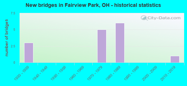
- New bridges - historical statistics
- 31930-1939
- 51970-1979
- 61980-1989
- 12010-2019

- Reconstructed bridges - Historical Statistics
- 11980-1989
- 11990-1999
- 02000-2009
- 02010-2019
- 12020-2022


- Bridge Condition - Deck
- 12.5%Very good
- 25.0%Good
- 37.5%Satisfactory
- 25.0%Poor

- Bridge Condition - Superstructure
- 12.5%Very good
- 50.0%Good
- 25.0%Satisfactory
- 12.5%Poor

- Bridge Condition - Substructure
- 12.5%Very good
- 12.5%Good
- 37.5%Satisfactory
- 25.0%Fair
- 12.5%Poor

- Bridge Condition - Channel
- 16.7%Excellent
- 16.7%Very good
- 33.3%Good
- 16.7%Satisfactory
- 16.7%Poor

- Bridge Condition - Culverts
- 50.0%Excellent
- 50.0%Serious
Find on map >> Show street view
Structure Number: 1801325, Location: APPROX 200FT W STORYRD (Lat: 41.451281, Lng: -81.824211), Route carried "on" structure: State highway 10, Year Built: 1935, Year Reconstructed: 1990, Status: Open, Structure Length: 37.49m (123.00ft), Average Daily Traffic: 11,449 (year 2015), Truck Traffic: 7%, Average Future Daily Traffic: 15,891 (year 2035), Design Load: HS 20, Features Intersected: VALLEY PKWY/ROCKY RIVER
Minimum Vertical Clearance: 30+ m (98+ ft), Kilometerpoint: 13.985, Lanes on structure: 4, Lanes under structure: 2, Base Highway Network: Yes, Owner: State Highway Agency, Approaching Roadway Width: 15.9m (52.2ft), Material/Design: Steel, Design/Construction: Arch - Deck, Number Of Spans In Main Unit: 4, Number Of Approach Spans: 5, Length of Maximum Span: 78.0m (255.9ft), Curb or Sidewalk Widths: Left: 1.5m (4.9ft), Right: 1.5m (4.9ft), Curb-To-Curb Width: 15.9m (52.2ft), Out-to-Out Width: 19.7m (64.6ft)
Condition: Deck: Satisfactory, Superstructure: Satisfactory, Substructure: Satisfactory, Channel: Good, Operating Rating: 40.8 metric tons, Method Used To Determine Operating Rating: Field evaluation and documented engineering judgment, Inventory Rating: 32.7 metric tons, Method Used To Determine Inventory Rating: Field evaluation and documented engineering judgment, Structural Evaluation: Equal to present minimum criteria, Deck Geometry: Meets minimum limits, Underclear: Equal to present minimum criteria, Waterway Adequacy: Equal to present desirable criteria, Approach Roadway Alignment: Equal to present desirable criteria, Designated Inspection Frequency: Every 12 months, Critical Feature Inspection Frequency: Every 24 months, Inspection Date: September 2021, Critical Feature Inspection Date: September 2021, Deck Structure Type: Concrete Cast-file-Place, Wearing Surface/Protective System: Wearing Surface: Latex Concrete, Deck Protection: Epoxy Coated Reinforcing
Find on map >> Show street view
Structure Number: 1802046, Location: APPROX 900FT E W220 ST (Lat: 41.420481, Lng: -81.861811), Route carried "on" structure: State highway 17, Year Built: 1933, Year Reconstructed: 1989, Status: Open, Structure Length: 58.49m (191.90ft), Average Daily Traffic: 14,415 (year 2015), Truck Traffic: 6%, Average Future Daily Traffic: 20,008 (year 2035), Design Load: H 20, Features Intersected: ROCKY RIVER
Minimum Vertical Clearance: 30+ m (98+ ft), Kilometerpoint: 4.554, Lanes on structure: 4, Owner: State Highway Agency, Approaching Roadway Width: 15.9m (52.2ft), Material/Design: Concrete, Design/Construction: Arch - Deck, Number Of Spans In Main Unit: 8, Number Of Approach Spans: 9, Length of Maximum Span: 58.5m (191.9ft), Curb or Sidewalk Widths: Left: 1.5m (4.9ft), Right: 1.5m (4.9ft), Curb-To-Curb Width: 15.9m (52.2ft), Out-to-Out Width: 19.7m (64.6ft)
Condition: Deck: Poor, Superstructure: Poor, Substructure: Poor, Channel: Poor, Operating Rating: 42.1 metric tons, Method Used To Determine Operating Rating: Load Factor (LF) rating reported by rating factor (RF) method using MS18 loading, Inventory Rating: 25.9 metric tons, Method Used To Determine Inventory Rating: Load Factor (LF) rating reported by rating factor (RF) method using MS18 loading, Structural Evaluation: Meets minimum limits, Deck Geometry: Meets minimum limits, Waterway Adequacy: Equal to present desirable criteria, Approach Roadway Alignment: Equal to present minimum criteria, Designated Inspection Frequency: Every 12 months, Inspection Date: September 2021, Deck Structure Type: Concrete Cast-file-Place, Wearing Surface/Protective System: Wearing Surface: Latex Concrete, Membrane: Built-up, Deck Protection: Epoxy Coated Reinforcing
Find on map >> Show street view
Structure Number: 1812831, Location: 2.07 MI. W. OF JCT. I-71 (Lat: 41.424461, Lng: -81.857789), Route carried "on" structure: Interstate 480, Year Built: 1970, Status: Open, Structure Length: 47.88m (157.09ft), Average Daily Traffic: 109,150 (year 2015), Truck Traffic: 5%, Average Future Daily Traffic: 151,500 (year 2035), Design Load: HS 20, Features Intersected: ROCKY RIVER
Minimum Vertical Clearance: 30+ m (98+ ft), Kilometerpoint: 10.412, Lanes on structure: 8, Lanes under structure: 2, Base Highway Network: Yes, Owner: State Highway Agency, Approaching Roadway Width: 31.4m (103.0ft), Material/Design: Steel, Design/Construction: Girder and Floorbeam System, Number Of Spans In Main Unit: 9, Length of Maximum Span: 61.0m (200.1ft), Curb-To-Curb Width: 43.3m (142.1ft), Out-to-Out Width: 43.9m (144.0ft)
Condition: Deck: Satisfactory, Superstructure: Satisfactory, Substructure: Satisfactory, Channel: Good, Operating Rating: 45.4 metric tons, Method Used To Determine Operating Rating: Load Factor (LF) rating reported by rating factor (RF) method using MS18 loading, Inventory Rating: 16.2 metric tons, Method Used To Determine Inventory Rating: Load Factor (LF) rating reported by rating factor (RF) method using MS18 loading, Structural Evaluation: Meets minimum limits, Deck Geometry: Superior to present desirable criteria, Underclear: Better than present minimum criteria, Waterway Adequacy: Equal to present desirable criteria, Approach Roadway Alignment: Equal to present desirable criteria, Designated Inspection Frequency: Every 12 months, Critical Feature Inspection Frequency: Every 24 months, Inspection Date: September 2021, Critical Feature Inspection Date: September 2020, Deck Structure Type: Concrete Cast-file-Place, Wearing Surface/Protective System: Wearing Surface: Latex Concrete
Find on map >> Show street view
Structure Number: 1814141, Location: 1.8 MI. E. OF JCT. SR-252 (Lat: 41.423969, Lng: -81.871950), Route carried "on" structure: City street 227, Year Built: 1980, Status: Open, Structure Length: 8.60m (28.22ft), Average Daily Traffic: 1,000 (year 2002), Average Future Daily Traffic: 151,500 (year 2022), Design Load: HS 20+Mod, Features Intersected: IR-480-0573
Minimum Vertical Clearance: 30+ m (98+ ft), Kilometerpoint: 77.265, Lanes on structure: 2, Lanes under structure: 8, Owner: State Highway Agency, Approaching Roadway Width: 7.3m (24.0ft), Skew: 1 degrees, Material/Design: Steel continuous, Design/Construction: Stringer/Multi-beam, Number Of Spans In Main Unit: 4, Length of Maximum Span: 25.0m (82.0ft), Curb or Sidewalk Widths: Left: 1.5m (4.9ft), Right: 1.5m (4.9ft), Curb-To-Curb Width: 7.3m (24.0ft), Out-to-Out Width: 11.1m (36.4ft)
Condition: Deck: Good, Superstructure: Good, Substructure: Good, Operating Rating: 58.3 metric tons, Method Used To Determine Operating Rating: Load Factor (LF) rating reported by rating factor (RF) method using MS18 loading, Inventory Rating: 35.6 metric tons, Method Used To Determine Inventory Rating: Load Factor (LF) rating reported by rating factor (RF) method using MS18 loading, Structural Evaluation: Better than present minimum criteria, Deck Geometry: Meets minimum limits, Underclear: Somewhat better than minimum adequacy, Approach Roadway Alignment: Equal to present desirable criteria, Designated Inspection Frequency: Every 24 months, Inspection Date: May 2021, Deck Structure Type: Concrete Cast-file-Place, Wearing Surface/Protective System: Wearing Surface: Monolithic Concrete, Deck Protection: Epoxy Coated Reinforcing
Find on map >> Show street view
Structure Number: 1814168, Location: 2.1 MI. E. OF JCT. SR-252 (Lat: 41.424439, Lng: -81.864650), Route carried "on" structure: County highway C0100, Year Built: 1980, Status: Open, Structure Length: 7.89m (25.89ft), Average Daily Traffic: 7,104 (year 2015), Truck Traffic: 5%, Average Future Daily Traffic: 9,860 (year 2035), Design Load: HS 20+Mod, Features Intersected: IR-480 (W220TH), Facility Carried by Structure: W. 220TH ST.
Minimum Vertical Clearance: 30+ m (98+ ft), Kilometerpoint: 0.346, Lanes on structure: 4, Lanes under structure: 8, Owner: State Highway Agency, Approaching Roadway Width: 15.9m (52.2ft), Material/Design: Steel continuous, Design/Construction: Stringer/Multi-beam, Number Of Spans In Main Unit: 4, Length of Maximum Span: 23.5m (77.1ft), Curb or Sidewalk Widths: Left: 1.5m (4.9ft), Right: 1.5m (4.9ft), Curb-To-Curb Width: 15.9m (52.2ft), Out-to-Out Width: 19.6m (64.3ft)
Condition: Deck: Poor, Superstructure: Good, Substructure: Satisfactory, Operating Rating: 42.1 metric tons, Method Used To Determine Operating Rating: Load Factor (LF) rating reported by rating factor (RF) method using MS18 loading, Inventory Rating: 32.4 metric tons, Method Used To Determine Inventory Rating: Load Factor (LF) rating reported by rating factor (RF) method using MS18 loading, Structural Evaluation: Equal to present minimum criteria, Deck Geometry: Meets minimum limits, Underclear: Somewhat better than minimum adequacy, Approach Roadway Alignment: Equal to present desirable criteria, Designated Inspection Frequency: Every 12 months, Inspection Date: May 2021, Deck Structure Type: Concrete Cast-file-Place, Wearing Surface/Protective System: Wearing Surface: Monolithic Concrete, Deck Protection: Epoxy Coated Reinforcing
Find on map >> Show street view
Structure Number: 1814176, Location: 2.2 MI. E. OF JCT SR-252 (Lat: 41.424450, Lng: -81.864289), Route carried "on" structure: County highway C0101, Year Built: 1980, Status: Open, Structure Length: 12.13m (39.80ft), Average Daily Traffic: 9,201 (year 2015), Truck Traffic: 7%, Average Future Daily Traffic: 12,771 (year 2035), Design Load: HS 20+Mod, Features Intersected: IR-480 (MASTICK), Facility Carried by Structure: MASTICK RD
Minimum Vertical Clearance: 30+ m (98+ ft), Kilometerpoint: 2.808, Lanes on structure: 2, Lanes under structure: 8, Owner: State Highway Agency, Approaching Roadway Width: 8.5m (27.9ft), Skew: 4 degrees, Material/Design: Steel continuous, Design/Construction: Stringer/Multi-beam, Number Of Spans In Main Unit: 4, Length of Maximum Span: 36.3m (119.1ft), Curb or Sidewalk Widths: Left: 1.5m (4.9ft), Right: 1.5m (4.9ft), Curb-To-Curb Width: 8.5m (27.9ft), Out-to-Out Width: 12.3m (40.4ft)
Condition: Deck: Satisfactory, Superstructure: Good, Substructure: Fair, Operating Rating: 42.1 metric tons, Method Used To Determine Operating Rating: Load Factor (LF) rating reported by rating factor (RF) method using MS18 loading, Inventory Rating: 32.4 metric tons, Method Used To Determine Inventory Rating: Load Factor (LF) rating reported by rating factor (RF) method using MS18 loading, Structural Evaluation: Somewhat better than minimum adequacy, Deck Geometry: Meets minimum limits, Underclear: Equal to present minimum criteria, Approach Roadway Alignment: Equal to present desirable criteria, Designated Inspection Frequency: Every 12 months, Inspection Date: May 2021, Deck Structure Type: Concrete Cast-file-Place, Wearing Surface/Protective System: Wearing Surface: Monolithic Concrete, Deck Protection: Epoxy Coated Reinforcing
Find on map >> Show street view
Structure Number: 183124, Location: 2980' N OF EATON ROAD (Lat: 41.435650, Lng: -81.846119), Route carried "on" structure: County highway C0101, Year Built: 1975, Year Reconstructed: 2020, Status: Open, Structure Length: 11.69m (38.35ft), Average Daily Traffic: 8,040 (year 2019), Truck Traffic: 4%, Average Future Daily Traffic: 8,360 (year 2039), Design Load: HS 20+Mod, Features Intersected: METROPARKS HILLSIDE, Facility Carried by Structure: MASTICK RD CR 101
Minimum Vertical Clearance: 30+ m (98+ ft), Kilometerpoint: 5.037, Lanes on structure: 2, Owner: County Highway Agency, Approaching Roadway Width: 9.1m (29.9ft), Skew: 9 degrees, Material/Design: Concrete continuous, Design/Construction: Slab, Number Of Spans In Main Unit: 13, Length of Maximum Span: 9.2m (30.2ft), Curb or Sidewalk Widths: Left: 0.0m, Right: 3.0m (9.8ft), Curb-To-Curb Width: 9.1m (29.9ft), Out-to-Out Width: 13.5m (44.3ft)
Condition: Deck: Very good, Superstructure: Very good, Substructure: Very good, Operating Rating: 52.8 metric tons, Method Used To Determine Operating Rating: Load and Resistance Factor Rating (LRFR) rating reported by rating factor(RF) method using HL-93 loadings, Inventory Rating: 40.8 metric tons, Method Used To Determine Inventory Rating: Load and Resistance Factor Rating (LRFR) rating reported by rating factor(RF) method using HL-93 loadings, Structural Evaluation: Equal to present desirable criteria, Deck Geometry: Meets minimum limits, Approach Roadway Alignment: Equal to present minimum criteria, Designated Inspection Frequency: Every 12 months, Inspection Date: May 2021, Deck Structure Type: Concrete Cast-file-Place, Wearing Surface/Protective System: Wearing Surface: Integral Concrete
Find on map >> Show street view
Structure Number: 1831623, Location: 58' E. OF VALLEY PARKWAY (Lat: 41.437739, Lng: -81.845161), Route carried "on" structure: County highway 189, Year Built: 1977, Status: Open, Structure Length: 6.07m (19.91ft), Average Daily Traffic: 10,355 (year 2015), Truck Traffic: 7%, Average Future Daily Traffic: 14,373 (year 2035), Design Load: HS 20+Mod, Features Intersected: ROCKY RIVER
Minimum Vertical Clearance: 30+ m (98+ ft), Kilometerpoint: 0.032, Lanes on structure: 2, Owner: County Highway Agency, Approaching Roadway Width: 8.5m (27.9ft), Material/Design: Concrete continuous, Design/Construction: Frame, Number Of Spans In Main Unit: 2, Length of Maximum Span: 29.7m (97.4ft), Curb or Sidewalk Widths: Left: 2.4m (7.9ft), Right: 1.8m (5.9ft), Curb-To-Curb Width: 8.5m (27.9ft), Out-to-Out Width: 13.4m (44.0ft)
Condition: Deck: Good, Superstructure: Good, Substructure: Fair, Channel: Very good, Operating Rating: 88.1 metric tons, Method Used To Determine Operating Rating: Load Factor (LF) rating reported by rating factor (RF) method using MS18 loading, Inventory Rating: 52.8 metric tons, Method Used To Determine Inventory Rating: Load Factor (LF) rating reported by rating factor (RF) method using MS18 loading, Structural Evaluation: Somewhat better than minimum adequacy, Deck Geometry: Meets minimum limits, Waterway Adequacy: Superior to present desirable criteria, Approach Roadway Alignment: Superior to present desirable criteria, Designated Inspection Frequency: Every 12 months, Inspection Date: May 2021, Deck Structure Type: Concrete Cast-file-Place, Wearing Surface/Protective System: Wearing Surface: Bituminous
Find on map >> Show street view
Structure Number: 1860011, Location: 1137' SE OF LAKE ROAD (Lat: 41.480119, Lng: -81.878831), Route carried "on" structure: City street QUEEN, Year Built: 2019, Status: Open, Structure Length: 1.01m (3.31ft), Average Daily Traffic: 550 (year 2018), Truck Traffic: 2%, Average Future Daily Traffic: 763 (year 2038), Design Load: HL 93, Features Intersected: SPERRY CREEK
Minimum Vertical Clearance: 30+ m (98+ ft), Kilometerpoint: 0.338, Lanes on structure: 2, Owner: City or Municipal Highway Agency, Approaching Roadway Width: 6.7m (22.0ft), Material/Design: Steel, Design/Construction: Culvert, Number Of Spans In Main Unit: 1, Length of Maximum Span: 9.8m (32.2ft), Curb or Sidewalk Widths: Left: 1.5m (4.9ft), Right: 1.5m (4.9ft)
Condition: Channel: Excellent, Culverts: Excellent, Operating Rating: 97.2 metric tons, Method Used To Determine Operating Rating: Load and Resistance Factor Rating (LRFR) rating reported by rating factor(RF) method using HL-93 loadings, Inventory Rating: 74.5 metric tons, Method Used To Determine Inventory Rating: Load and Resistance Factor Rating (LRFR) rating reported by rating factor(RF) method using HL-93 loadings, Structural Evaluation: Superior to present desirable criteria, Waterway Adequacy: Superior to present desirable criteria, Approach Roadway Alignment: Equal to present desirable criteria, Designated Inspection Frequency: Every 12 months, Inspection Date: October 2021
Find on map >> Show street view
Structure Number: 1860015, Location: 0.5 MI N OF S.R. 17 (Lat: 41.428361, Lng: -81.871789), Route carried "on" structure: City street 227TH, Year Built: 1973, Status: Posted for load, Structure Length: 0.76m (2.49ft), Average Daily Traffic: 300 (year 2019), Truck Traffic: 3%, Average Future Daily Traffic: 416 (year 2039), Design Load: HS 20, Features Intersected: Coe Creek, Facility Carried by Structure: West 227th St.
Minimum Vertical Clearance: 30+ m (98+ ft), Kilometerpoint: 0.716, Lanes on structure: 2, Owner: City or Municipal Highway Agency, Approaching Roadway Width: 8.1m (26.6ft), Skew: 3 degrees, Material/Design: Steel, Design/Construction: Culvert, Number Of Spans In Main Unit: 1, Length of Maximum Span: 7.0m (23.0ft), Curb or Sidewalk Widths: Left: 1.5m (4.9ft), Right: 1.5m (4.9ft)
Condition: Channel: Satisfactory, Culverts: Serious, Operating Rating: 13.0 metric tons, Method Used To Determine Operating Rating: Load and Resistance Factor Rating (LRFR) rating reported by rating factor(RF) method using HL-93 loadings, Inventory Rating: 9.7 metric tons, Method Used To Determine Inventory Rating: Load and Resistance Factor Rating (LRFR) rating reported by rating factor(RF) method using HL-93 loadings, Structural Evaluation: High priority of corrective action, Waterway Adequacy: Superior to present desirable criteria, Approach Roadway Alignment: Equal to present minimum criteria, Bridge Posting: Required (Relationship of Operating Rating to Maximum Legal Load: > 39.9% below), Designated Inspection Frequency: Every 12 months, Inspection Date: September 2021
Find on map >> Show street view
Structure Number: 1801325, Location: APPROX 200FT W STORYRD (Lat: 41.451281, Lng: -81.824211), Route carried "under" structure: City street Vally, Year Built: 1935, Structure Length: 0. m, Average Daily Traffic: 100 (year 2015), Truck Traffic: 5%, Features Intersected: SR10 Lorain Rd, Facility Carried by Structure: SR 10
Minimum Vertical Clearance: 28.96m (95.01ft), Kilometerpoint: 0.016, Lanes on structure: 4, Lanes under structure: 2, Material/Design: Steel, Design/Construction: Arch - Deck, Length of Maximum Span: 78.0m (255.9ft)
Find on map >> Show street view
Structure Number: 1812831, Location: 2.07 MI. W. OF JCT. I-71 (Lat: 41.424461, Lng: -81.857789), Route carried "under" structure: City street vally, Year Built: 1970, Structure Length: 0. m, Features Intersected: IR-480, Facility Carried by Structure: IR 480
Minimum Vertical Clearance: 30+ m (98+ ft), Lanes on structure: 8, Lanes under structure: 2, Material/Design: Steel, Design/Construction: Girder and Floorbeam System, Length of Maximum Span: 61.0m (200.1ft)
Find on map >> Show street view
Structure Number: 1814141, Location: 1.8 MI. E. OF JCT. SR-252 (Lat: 41.423969, Lng: -81.871950), Route carried "under" structure: Interstate 480, Year Built: 1980, Structure Length: 0. m, Average Daily Traffic: 109,150 (year 2015), Truck Traffic: 5%, Features Intersected: IR 480 (W. 227TH), Facility Carried by Structure: W. 227TH ST.
Minimum Vertical Clearance: 5.31m (17.42ft), Kilometerpoint: 9.222, Lanes on structure: 2, Lanes under structure: 8, Material/Design: Steel continuous, Design/Construction: Stringer/Multi-beam, Length of Maximum Span: 25.0m (82.0ft)
Find on map >> Show street view
Structure Number: 1814168, Location: 2.1 MI. E. OF JCT. SR-252 (Lat: 41.424439, Lng: -81.864650), Route carried "under" structure: Interstate 480, Year Built: 1980, Structure Length: 0. m, Average Daily Traffic: 116,910 (year 2016), Truck Traffic: 5%, Features Intersected: CR-100 (W 220TH ST), Facility Carried by Structure: W. 220TH ST.
Minimum Vertical Clearance: 5.48m (17.98ft), Kilometerpoint: 9.819, Lanes on structure: 4, Lanes under structure: 8, Material/Design: Steel continuous, Design/Construction: Stringer/Multi-beam, Length of Maximum Span: 23.5m (77.1ft)
Find on map >> Show street view
Structure Number: 1814176, Location: 2.2 MI. E. OF JCT SR-252 (Lat: 41.424450, Lng: -81.864289), Route carried "under" structure: Interstate 480, Year Built: 1980, Structure Length: 0. m, Average Daily Traffic: 116,910 (year 2016), Truck Traffic: 5%, Features Intersected: CR-101 (MASTICK RD), Facility Carried by Structure: MASTICK RD
Minimum Vertical Clearance: 5.49m (18.01ft), Kilometerpoint: 9.881, Lanes on structure: 2, Lanes under structure: 8, Material/Design: Steel continuous, Design/Construction: Stringer/Multi-beam, Length of Maximum Span: 36.3m (119.1ft)