Bridge Statistics for Fairview, Texas (TX)
Condition, Traffic, Stress, Structural Evaluation, Project Costs
- National Bridge Inventory (NBI) Statistics
- 20Number of bridges
- 653ft / 199mTotal length
- 692,502Total average daily traffic
- 43,629Total average daily truck traffic
- National Bridge Inventory (NBI) Registered Bridges for Fairview
- No street view available for this location
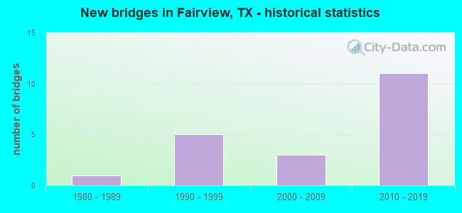
- New bridges - historical statistics
- 11980-1989
- 51990-1999
- 32000-2009
- 112010-2019
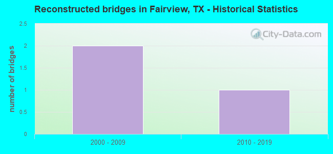
- Reconstructed bridges - Historical Statistics
- 22000-2009
- 12010-2019
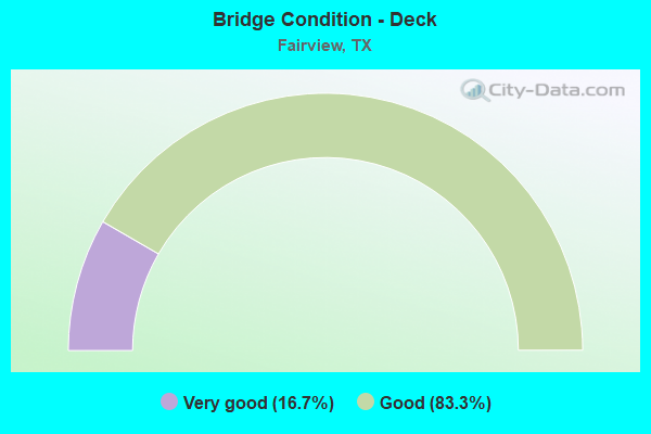
- Bridge Condition - Deck
- 16.7%Very good
- 83.3%Good
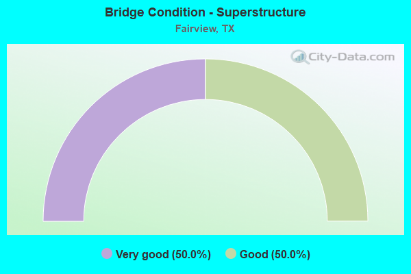
- Bridge Condition - Superstructure
- 50.0%Very good
- 50.0%Good
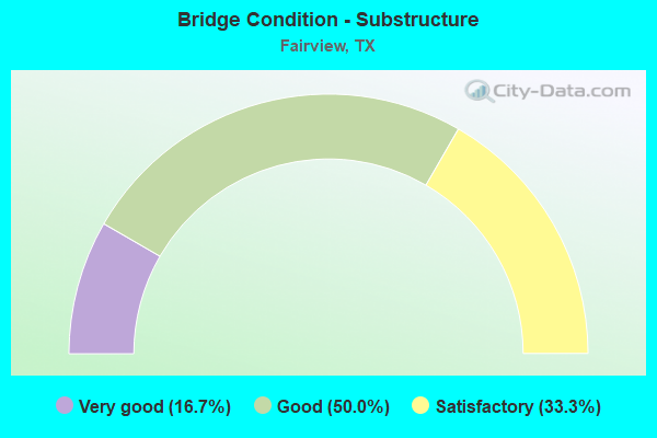
- Bridge Condition - Substructure
- 16.7%Very good
- 50.0%Good
- 33.3%Satisfactory
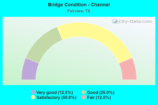
- Bridge Condition - Channel
- 12.5%Very good
- 25.0%Good
- 50.0%Satisfactory
- 12.5%Fair
Find on map >> Show street view
Structure Number: 18043000470641, Location: 2.2 MI N OF FM 2170 (Lat: 33.130217, Lng: -96.659222), Route carried "on" structure: US 75, Year Built: 1999, Year Reconstructed: 2015, Status: Open, Structure Length: 11.06m (36.29ft), Average Daily Traffic: 65,851 (year 2019), Truck Traffic: 7%, Average Future Daily Traffic: 178,297 (year 2038), Design Load: HS 20, Features Intersected: FM 2786/STACY RD
Minimum Vertical Clearance: 30+ m (98+ ft), Kilometerpoint: 6.457, Lanes on structure: 5, Lanes under structure: 8, Base Highway Network: Yes, Owner: State Highway Agency, Approaching Roadway Width: 23.2m (76.1ft), Skew: 3 degrees, Material/Design: Prestressed concrete, Design/Construction: Stringer/Multi-beam, Number Of Spans In Main Unit: 3, Length of Maximum Span: 39.0m (128.0ft), Curb-To-Curb Width: 23.3m (76.4ft), Out-to-Out Width: 24.1m (79.1ft)
Condition: Deck: Good, Superstructure: Good, Substructure: Good, Operating Rating: 54.4 metric tons, Method Used To Determine Operating Rating: Assigned rating based on Load Factor Design (LFD) reported in metric tons, Inventory Rating: 32.7 metric tons, Method Used To Determine Inventory Rating: Assigned rating based on Load Factor Design (LFD) reported in metric tons, Structural Evaluation: Better than present minimum criteria, Deck Geometry: Somewhat better than minimum adequacy, Underclear: High priority of corrective action, Approach Roadway Alignment: Equal to present desirable criteria, Designated Inspection Frequency: Every 24 months, Inspection Date: October 2021, Deck Structure Type: Concrete Cast-file-Place
Find on map >> Show street view
Structure Number: 180430004706455, Location: AT INT OF US 75 & SH 121 (Lat: 33.152967, Lng: -96.647019), Route carried "on" structure: US 121, Year Built: 2011, Status: Open, Structure Length: 90.56m (297.11ft), Average Daily Traffic: 953 (year 2018), Average Future Daily Traffic: 1,334 (year 2038), Design Load: HL 93, Features Intersected: SH 121 & US 75, Facility Carried by Structure: NW DIRECT CONNECT
Minimum Vertical Clearance: 5.51m (18.08ft), Kilometerpoint: 3.058, Lanes on structure: 1, Lanes under structure: 24, Owner: Local Toll Authority, Approaching Roadway Width: 12.2m (40.0ft), Skew: 9 degrees, Material/Design: Prestressed concrete, Design/Construction: Stringer/Multi-beam, Number Of Spans In Main Unit: 19, Number Of Approach Spans: 7, Length of Maximum Span: 38.1m (125.0ft), Curb-To-Curb Width: 7.9m (25.9ft), Out-to-Out Width: 8.5m (27.9ft)
Condition: Deck: Good, Superstructure: Very good, Substructure: Satisfactory, Operating Rating: 54.4 metric tons, Method Used To Determine Operating Rating: Assigned ratings based on Load and Resistance Factor Design (LRFD) reported in metric tons, Inventory Rating: 32.7 metric tons, Method Used To Determine Inventory Rating: Assigned ratings based on Load and Resistance Factor Design (LRFD) reported in metric tons, Structural Evaluation: Equal to present minimum criteria, Deck Geometry: Somewhat better than minimum adequacy, Underclear: High priority of corrective action, Approach Roadway Alignment: Equal to present desirable criteria, Designated Inspection Frequency: Every 24 months, Inspection Date: October 2021, Deck Structure Type: Concrete Cast-file-Place
Find on map >> Show street view
Structure Number: 180430004706619, Location: 0.7 MI S OF SH 121 (Lat: 33.148539, Lng: -96.648633), Route carried "on" structure: US 75, Year Built: 2000, Year Reconstructed: 2011, Status: Open, Structure Length: 1.52m (4.99ft), Average Daily Traffic: 121,625 (year 2020), Truck Traffic: 7%, Average Future Daily Traffic: 178,297 (year 2038), Design Load: HS 20, Features Intersected: DRAW
Minimum Vertical Clearance: 30+ m (98+ ft), Kilometerpoint: 4.233, Lanes on structure: 15, Base Highway Network: Yes, Owner: State Highway Agency, Approaching Roadway Width: 77.4m (253.9ft), Skew: 33 degrees, Material/Design: Concrete, Design/Construction: Culvert, Number Of Spans In Main Unit: 4, Length of Maximum Span: 3.0m (9.8ft)
Condition: Channel: Good, Culverts: Good, Operating Rating: 54.4 metric tons, Method Used To Determine Operating Rating: Assigned rating based on Load Factor Design (LFD) reported in metric tons, Inventory Rating: 32.7 metric tons, Method Used To Determine Inventory Rating: Assigned rating based on Load Factor Design (LFD) reported in metric tons, Structural Evaluation: Better than present minimum criteria, Waterway Adequacy: Superior to present desirable criteria, Approach Roadway Alignment: Equal to present desirable criteria, Designated Inspection Frequency: Every 24 months, Inspection Date: October 2021
Find on map >> Show street view
Structure Number: 18043000470662, Location: 0.45 MI S OF SH 121 (Lat: 33.152139, Lng: -96.647275), Route carried "on" structure: US 75, Year Built: 2000, Year Reconstructed: 2011, Status: Open, Structure Length: 1.28m (4.20ft), Average Daily Traffic: 121,625 (year 2020), Truck Traffic: 7%, Average Future Daily Traffic: 178,297 (year 2038), Design Load: HS 20, Features Intersected: SLOAN CREEK
Minimum Vertical Clearance: 5.11m (16.77ft), Kilometerpoint: 3.830, Lanes on structure: 12, Base Highway Network: Yes, Owner: State Highway Agency, Approaching Roadway Width: 69.5m (228.0ft), Skew: 30 degrees, Material/Design: Concrete, Design/Construction: Culvert, Number Of Spans In Main Unit: 4, Length of Maximum Span: 2.7m (8.9ft)
Condition: Channel: Satisfactory, Culverts: Good, Operating Rating: 54.4 metric tons, Method Used To Determine Operating Rating: Assigned rating based on Load Factor Design (LFD) reported in metric tons, Inventory Rating: 32.7 metric tons, Method Used To Determine Inventory Rating: Assigned rating based on Load Factor Design (LFD) reported in metric tons, Structural Evaluation: Better than present minimum criteria, Waterway Adequacy: Superior to present desirable criteria, Approach Roadway Alignment: Equal to present desirable criteria, Designated Inspection Frequency: Every 24 months, Inspection Date: October 2021
Find on map >> Show street view
Structure Number: 180430036404615, Location: AT INT US 75 & SH 121 (Lat: 33.154025, Lng: -96.646619), Route carried "on" structure: State highway 121, Year Built: 2011, Status: Open, Structure Length: 80.01m (262.50ft), Average Daily Traffic: 2,500 (year 2012), Truck Traffic: 6%, Average Future Daily Traffic: 7,116 (year 2030), Design Load: HL 93, Features Intersected: US75 & SH121 CONNECTORS, Facility Carried by Structure: NE DIRECT CONN
Minimum Vertical Clearance: 5.21m (17.09ft), Kilometerpoint: 0.000, Lanes on structure: 1, Lanes under structure: 7, Toll: On toll road, Owner: Local Toll Authority, Approaching Roadway Width: 7.9m (25.9ft), Material/Design: Prestressed concrete, Design/Construction: Stringer/Multi-beam, Number Of Spans In Main Unit: 21, Length of Maximum Span: 38.1m (125.0ft), Curb-To-Curb Width: 7.9m (25.9ft), Out-to-Out Width: 8.5m (27.9ft)
Condition: Deck: Good, Superstructure: Very good, Substructure: Good, Operating Rating: 54.4 metric tons, Method Used To Determine Operating Rating: Assigned ratings based on Load and Resistance Factor Design (LRFD) reported in metric tons, Inventory Rating: 32.7 metric tons, Method Used To Determine Inventory Rating: Assigned ratings based on Load and Resistance Factor Design (LRFD) reported in metric tons, Structural Evaluation: Better than present minimum criteria, Deck Geometry: High priority of corrective action, Underclear: High priority of corrective action, Approach Roadway Alignment: Equal to present desirable criteria, Designated Inspection Frequency: Every 24 months, Inspection Date: December 2019, Deck Structure Type: Concrete Precast Panels
Find on map >> Show street view
Structure Number: 180430139201006, Location: 0.95 MI N OF FM 2786 (Lat: 33.141419, Lng: -96.606775), Route carried "on" structure: State highway 1378, Year Built: 1981, Status: Open, Structure Length: 4.02m (13.19ft), Average Daily Traffic: 6,827 (year 2020), Truck Traffic: 5%, Average Future Daily Traffic: 11,367 (year 2038), Design Load: HS 20, Features Intersected: SLOAN CREEK
Minimum Vertical Clearance: 30+ m (98+ ft), Kilometerpoint: 5.306, Lanes on structure: 2, Owner: State Highway Agency, Approaching Roadway Width: 7.3m (24.0ft), Skew: 3 degrees, Material/Design: Concrete, Design/Construction: Stringer/Multi-beam, Number Of Spans In Main Unit: 4, Length of Maximum Span: 10.1m (33.1ft), Curb-To-Curb Width: 12.3m (40.4ft), Out-to-Out Width: 12.9m (42.3ft)
Condition: Deck: Good, Superstructure: Good, Substructure: Good, Channel: Satisfactory, Operating Rating: 54.4 metric tons, Method Used To Determine Operating Rating: Assigned rating based on Load Factor Design (LFD) reported in metric tons, Inventory Rating: 32.7 metric tons, Method Used To Determine Inventory Rating: Assigned rating based on Load Factor Design (LFD) reported in metric tons, Structural Evaluation: Better than present minimum criteria, Deck Geometry: Somewhat better than minimum adequacy, Waterway Adequacy: Equal to present minimum criteria, Approach Roadway Alignment: Equal to present minimum criteria, Designated Inspection Frequency: Every 24 months, Inspection Date: November 2019, Deck Structure Type: Concrete Cast-file-Place
Find on map >> Show street view
Structure Number: 180430AA0728001, Location: 0.10 MI NE OF CR 323 (Lat: 33.139992, Lng: -96.576528), Route carried "on" structure: County highway 317, Year Built: 2017, Status: Open, Structure Length: 1.98m (6.50ft), Average Daily Traffic: 1,269 (year 2014), Average Future Daily Traffic: 1,000 (year 2031), Design Load: HL 93, Features Intersected: WILSON CREEK
Minimum Vertical Clearance: 30+ m (98+ ft), Kilometerpoint: 0.483, Lanes on structure: 2, Owner: County Highway Agency, Approaching Roadway Width: 7.3m (24.0ft), Material/Design: Prestressed concrete, Design/Construction: Box Beam or Girders - Multiple, Number Of Spans In Main Unit: 1, Length of Maximum Span: 19.8m (65.0ft), Curb-To-Curb Width: 7.3m (24.0ft), Out-to-Out Width: 8.0m (26.2ft)
Condition: Deck: Very good, Superstructure: Very good, Substructure: Very good, Channel: Very good, Operating Rating: 54.4 metric tons, Method Used To Determine Operating Rating: Assigned ratings based on Load and Resistance Factor Design (LRFD) reported in metric tons, Inventory Rating: 32.7 metric tons, Method Used To Determine Inventory Rating: Assigned ratings based on Load and Resistance Factor Design (LRFD) reported in metric tons, Structural Evaluation: Equal to present desirable criteria, Deck Geometry: Meets minimum limits, Waterway Adequacy: Meets minimum limits, Approach Roadway Alignment: Equal to present desirable criteria, Designated Inspection Frequency: Every 24 months, Inspection Date: January 2021, Deck Structure Type: Concrete Cast-file-Place
Find on map >> Show street view
Structure Number: 180430P00020001, Location: 0.80 MI N OF STACY RD (Lat: 33.139294, Lng: -96.629961), Route carried "on" structure: City street , Year Built: 2009, Status: Open, Structure Length: 1.04m (3.41ft), Average Daily Traffic: 70 (year 2018), Truck Traffic: 3%, Average Future Daily Traffic: 108 (year 2038), Features Intersected: TRIB SLOAN CREEK, Facility Carried by Structure: N MEANDERING WAY
Minimum Vertical Clearance: 30+ m (98+ ft), Kilometerpoint: 1.287, Lanes on structure: 2, Owner: Town or Township Highway Agency, Approaching Roadway Width: 7.9m (25.9ft), Skew: 1 degrees, Material/Design: Concrete, Design/Construction: Culvert, Number Of Spans In Main Unit: 3, Length of Maximum Span: 3.0m (9.8ft), Curb or Sidewalk Widths: Left: 0.0m, Right: 1.8m (5.9ft), Curb-To-Curb Width: 9.5m (31.2ft), Out-to-Out Width: 19.5m (64.0ft)
Condition: Channel: Good, Culverts: Good, Operating Rating: 32.7 metric tons, Method Used To Determine Operating Rating: Field evaluation and documented engineering judgment, Inventory Rating: 24.5 metric tons, Method Used To Determine Inventory Rating: Field evaluation and documented engineering judgment, Structural Evaluation: Equal to present minimum criteria, Deck Geometry: Better than present minimum criteria, Waterway Adequacy: Equal to present minimum criteria, Approach Roadway Alignment: Equal to present desirable criteria, Designated Inspection Frequency: Every 24 months, Inspection Date: August 2020, Deck Structure Type: Concrete Cast-file-Place, Wearing Surface/Protective System: Wearing Surface: Bituminous
Find on map >> Show street view
Structure Number: 180430P00136001, Location: 0.2 MI N OF FM 2786 (Lat: 33.133136, Lng: -96.621656), Route carried "on" structure: City street , Year Built: 1997, Status: Open, Structure Length: 0.88m (2.89ft), Average Daily Traffic: 981 (year 2014), Average Future Daily Traffic: 640 (year 2031), Design Load: HS 20, Features Intersected: DRAW, Facility Carried by Structure: OAKWOOD TRAIL
Minimum Vertical Clearance: 30+ m (98+ ft), Kilometerpoint: 0.002, Lanes on structure: 2, Owner: City or Municipal Highway Agency, Approaching Roadway Width: 7.9m (25.9ft), Material/Design: Concrete, Design/Construction: Culvert, Number Of Spans In Main Unit: 3, Length of Maximum Span: 2.4m (7.9ft), Out-to-Out Width: 14.9m (48.9ft)
Condition: Channel: Satisfactory, Culverts: Good, Operating Rating: 39.9 metric tons, Method Used To Determine Operating Rating: Load Factor (LF), Inventory Rating: 23.6 metric tons, Method Used To Determine Inventory Rating: Load Factor (LF), Structural Evaluation: Equal to present minimum criteria, Waterway Adequacy: Better than present minimum criteria, Approach Roadway Alignment: Equal to present desirable criteria, Designated Inspection Frequency: Every 24 months, Inspection Date: January 2021
Find on map >> Show street view
Structure Number: 180430P00136002, Location: 0.50 MI N OF FM 2786 (Lat: 33.136019, Lng: -96.621694), Route carried "on" structure: City street , Year Built: 1997, Status: Open, Structure Length: 0.64m (2.10ft), Average Daily Traffic: 981 (year 2014), Average Future Daily Traffic: 640 (year 2031), Features Intersected: DRAW, Facility Carried by Structure: OAKWOOD TR
Minimum Vertical Clearance: 30+ m (98+ ft), Kilometerpoint: 0.002, Lanes on structure: 2, Owner: City or Municipal Highway Agency, Approaching Roadway Width: 7.9m (25.9ft), Skew: 3 degrees, Material/Design: Concrete, Design/Construction: Culvert, Number Of Spans In Main Unit: 2, Length of Maximum Span: 2.4m (7.9ft)
Condition: Channel: Satisfactory, Culverts: Good, Operating Rating: 32.7 metric tons, Method Used To Determine Operating Rating: Field evaluation and documented engineering judgment, Inventory Rating: 24.5 metric tons, Method Used To Determine Inventory Rating: Field evaluation and documented engineering judgment, Structural Evaluation: Equal to present minimum criteria, Waterway Adequacy: Better than present minimum criteria, Approach Roadway Alignment: Equal to present desirable criteria, Designated Inspection Frequency: Every 24 months, Inspection Date: April 2021
Find on map >> Show street view
Structure Number: 180430P00195001, Location: 0.15 MI S OF PATRICIAN CT (Lat: 33.144508, Lng: -96.617531), Route carried "on" structure: City street , Year Built: 1997, Status: Open, Structure Length: 6.19m (20.31ft), Average Daily Traffic: 499 (year 2019), Truck Traffic: 2%, Average Future Daily Traffic: 480 (year 2031), Features Intersected: SLOAN CREEK, Facility Carried by Structure: PARKDALE
Minimum Vertical Clearance: 30+ m (98+ ft), Kilometerpoint: 0.002, Lanes on structure: 2, Owner: City or Municipal Highway Agency, Approaching Roadway Width: 7.9m (25.9ft), Material/Design: Concrete, Design/Construction: Stringer/Multi-beam, Number Of Spans In Main Unit: 5, Length of Maximum Span: 12.5m (41.0ft), Curb-To-Curb Width: 7.9m (25.9ft), Out-to-Out Width: 8.5m (27.9ft)
Condition: Deck: Good, Superstructure: Good, Substructure: Satisfactory, Channel: Fair, Operating Rating: 32.7 metric tons, Method Used To Determine Operating Rating: Field evaluation and documented engineering judgment, Inventory Rating: 24.5 metric tons, Method Used To Determine Inventory Rating: Field evaluation and documented engineering judgment, Structural Evaluation: Equal to present minimum criteria, Deck Geometry: Somewhat better than minimum adequacy, Waterway Adequacy: Superior to present desirable criteria, Approach Roadway Alignment: Equal to present minimum criteria, Designated Inspection Frequency: Every 24 months, Inspection Date: January 2021, Deck Structure Type: Concrete Cast-file-Place
Find on map >> Show street view
Structure Number: 18043000470641, Location: 2.2 MI N OF FM 2170 (Lat: 33.130217, Lng: -96.659222), Route carried "under" structure: State highway 2786, Year Built: 1999, Structure Length: 0. m, Average Daily Traffic: 33,987 (year 2018), Truck Traffic: 5%, Features Intersected: FM 2786/STACY RD, Facility Carried by Structure: US 75 NB
Minimum Vertical Clearance: 5.08m (16.67ft), Kilometerpoint: 0.000, Lanes on structure: 5, Lanes under structure: 8, Material/Design: Prestressed concrete, Design/Construction: Stringer/Multi-beam, Length of Maximum Span: 39.0m (128.0ft)
Find on map >> Show street view
Structure Number: 180430004706455, Location: AT INT OF US 75 & SH 121 (Lat: 33.155231, Lng: -96.647194), Route carried "under" structure: ServiceUS 75, Year Built: 2011, Structure Length: 0. m, Average Daily Traffic: 21,827 (year 2018), Truck Traffic: 3%, Features Intersected: US 75 SBFR, Facility Carried by Structure: NW DIRECT CONNECT
Minimum Vertical Clearance: 6.65m (21.82ft), Kilometerpoint: 0.000, Lanes on structure: 1, Lanes under structure: 24, Material/Design: Prestressed concrete, Design/Construction: Stringer/Multi-beam, Length of Maximum Span: 38.1m (125.0ft)
Find on map >> Show street view
Structure Number: 180430004706455, Location: AT INT OF US 75 & SH 121 (Lat: 33.156317, Lng: -96.649661), Route carried "under" structure: Other road 121, Year Built: 2011, Structure Length: 0. m, Average Daily Traffic: 45,592 (year 2018), Truck Traffic: 6%, Features Intersected: SH 121 SBML, Facility Carried by Structure: NW DIRECT CONNECT
Minimum Vertical Clearance: 6.40m (21.00ft), Kilometerpoint: 0.000, Lanes on structure: 1, Lanes under structure: 24, Toll: On toll road, Material/Design: Prestressed concrete, Design/Construction: Stringer/Multi-beam, Length of Maximum Span: 38.1m (125.0ft)
Find on map >> Show street view
Structure Number: 180430004706455, Location: AT INT OF US 75 & SH 121 (Lat: 33.156222, Lng: -96.649192), Route carried "under" structure: Other road 121, Year Built: 2011, Structure Length: 0. m, Average Daily Traffic: 45,592 (year 2018), Truck Traffic: 6%, Features Intersected: SH 121 NBML, Facility Carried by Structure: NW DIRECT CONNECT
Minimum Vertical Clearance: 5.49m (18.01ft), Kilometerpoint: 0.000, Lanes on structure: 1, Lanes under structure: 24, Toll: On toll road, Material/Design: Prestressed concrete, Design/Construction: Stringer/Multi-beam, Length of Maximum Span: 38.1m (125.0ft)
Find on map >> Show street view
Structure Number: 180430004706455, Location: AT INT OF US 75 & SH 121 (Lat: 33.156158, Lng: -96.648847), Route carried "under" structure: ServiceOther road 121, Year Built: 2011, Structure Length: 0. m, Average Daily Traffic: 45,592 (year 2018), Truck Traffic: 6%, Features Intersected: SH 121 NBFR, Facility Carried by Structure: NW DIRECT CONNECT
Minimum Vertical Clearance: 6.25m (20.51ft), Kilometerpoint: 0.000, Lanes on structure: 1, Lanes under structure: 24, Material/Design: Prestressed concrete, Design/Construction: Stringer/Multi-beam, Length of Maximum Span: 38.1m (125.0ft)
Find on map >> Show street view
Structure Number: 180430004706455, Location: AT INT OF US 75 & SH 121 (Lat: 33.153722, Lng: -96.646756), Route carried "under" structure: ServiceUS 75, Year Built: 2011, Structure Length: 0. m, Average Daily Traffic: 18,549 (year 2018), Truck Traffic: 3%, Features Intersected: US 75 NBFR RAMP, Facility Carried by Structure: NW DIRECT CONNECT
Minimum Vertical Clearance: 5.66m (18.57ft), Kilometerpoint: 0.000, Lanes on structure: 1, Lanes under structure: 24, Material/Design: Prestressed concrete, Design/Construction: Stringer/Multi-beam, Length of Maximum Span: 38.1m (125.0ft)
Find on map >> Show street view
Structure Number: 180430004706455, Location: AT INT OF US 75 & SH 121 (Lat: 33.155114, Lng: -96.647114), Route carried "under" structure: ServiceUS 75, Year Built: 2011, Structure Length: 0. m, Average Daily Traffic: 21,827 (year 2018), Truck Traffic: 3%, Features Intersected: US 75 SBML EXIT, Facility Carried by Structure: NW DIRECT CONNECT
Minimum Vertical Clearance: 7.80m (25.59ft), Kilometerpoint: 0.000, Lanes on structure: 1, Lanes under structure: 24, Material/Design: Prestressed concrete, Design/Construction: Stringer/Multi-beam, Length of Maximum Span: 38.1m (125.0ft)
Find on map >> Show street view
Structure Number: 180430004706455, Location: AT INT OF US 75 & SH 121 (Lat: 33.154858, Lng: -96.646972), Route carried "under" structure: US 75, Year Built: 2011, Structure Length: 0. m, Average Daily Traffic: 127,355 (year 2018), Truck Traffic: 7%, Features Intersected: US 75 SBML, Facility Carried by Structure: NW DIRECT CONNECT
Minimum Vertical Clearance: 6.10m (20.01ft), Kilometerpoint: 0.000, Lanes on structure: 1, Lanes under structure: 24, Material/Design: Prestressed concrete, Design/Construction: Stringer/Multi-beam, Length of Maximum Span: 38.1m (125.0ft)
Structure Number: 180430036404615, Location: AT INT US 75 & SH 121, Route carried "under" structure: Ramp State highway 75, Year Built: 2011, Structure Length: 0. m, Average Daily Traffic: 9,000 (year 2012), Truck Traffic: 9%, Features Intersected: US75 & SH121 CONNECTORS, Facility Carried by Structure: NE DIRECT CONN
Minimum Vertical Clearance: 8.76m (28.74ft), Kilometerpoint: 0.000, Material/Design: Prestressed concrete, Design/Construction: Stringer/Multi-beam, Length of Maximum Span: 38.1m (125.0ft)
Minimum Vertical Clearance: 8.76m (28.74ft), Kilometerpoint: 0.000, Material/Design: Prestressed concrete, Design/Construction: Stringer/Multi-beam, Length of Maximum Span: 38.1m (125.0ft)