Bridge Statistics for Fairwood, Washington (WA)
Condition, Traffic, Stress, Structural Evaluation, Project Costs
- National Bridge Inventory (NBI) Statistics
- 19Number of bridges
- 531ft / 162mTotal length
- $113,748,000Total costs
- 142,698Total average daily traffic
- 6,715Total average daily truck traffic
- National Bridge Inventory (NBI) Registered Bridges for Fairwood
- No street view available for this location
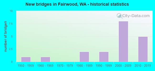
- New bridges - historical statistics
- 11950-1959
- 11960-1969
- 21980-1989
- 21990-1999
- 82000-2009
- 52010-2019

- Bridge Condition - Deck
- 28.6%Very good
- 50.0%Good
- 14.3%Satisfactory
- 7.1%Poor
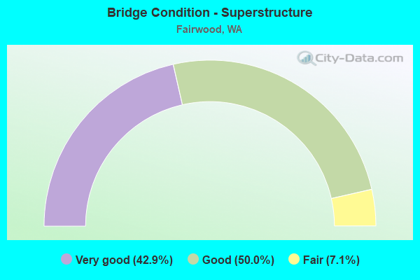
- Bridge Condition - Superstructure
- 42.9%Very good
- 50.0%Good
- 7.1%Fair
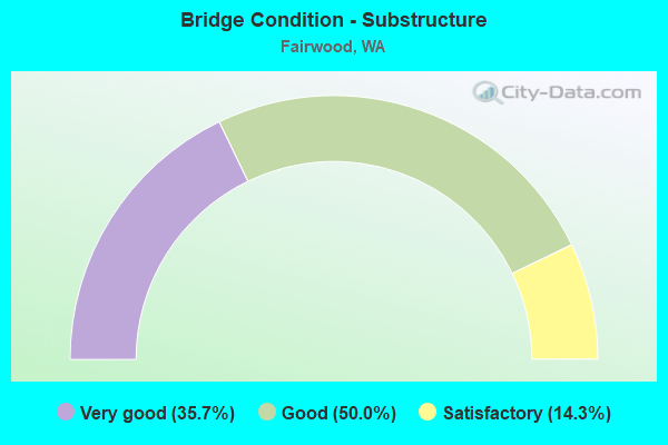
- Bridge Condition - Substructure
- 35.7%Very good
- 50.0%Good
- 14.3%Satisfactory
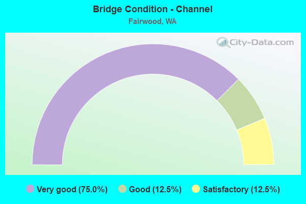
- Bridge Condition - Channel
- 75.0%Very good
- 12.5%Good
- 12.5%Satisfactory
Find on map >> Show street view
Structure Number: 4332A, Location: 3.2 N JCT US 2 (Lat: 47.784472, Lng: -117.404117), Route carried "on" structure: County highway 5199, Year Built: 1953, Status: Open, Structure Length: 14.60m (47.90ft), Average Daily Traffic: 5,394 (year 2019), Truck Traffic: 6%, Average Future Daily Traffic: 7,767 (year 2041), Design Load: HS 15, Features Intersected: LITTLE SPOKANE R, Facility Carried by Structure: WANDERMERE RD.
Minimum Vertical Clearance: 30+ m (98+ ft), Kilometerpoint: 0.001, Lanes on structure: 2, Lanes under structure: 2, Owner: County Highway Agency, Approaching Roadway Width: 12.8m (42.0ft), Material/Design: Concrete continuous, Design/Construction: Tee Beam, Number Of Spans In Main Unit: 8, Length of Maximum Span: 21.3m (69.9ft), Curb-To-Curb Width: 10.4m (34.1ft), Out-to-Out Width: 11.3m (37.1ft)
Condition: Deck: Satisfactory, Superstructure: Fair, Substructure: Satisfactory, Channel: Very good, Operating Rating: 42.6 metric tons, Method Used To Determine Operating Rating: Load and Resistance Factor (LRFR), Inventory Rating: 25.4 metric tons, Method Used To Determine Inventory Rating: Load and Resistance Factor (LRFR), Structural Evaluation: Somewhat better than minimum adequacy, Deck Geometry: Meets minimum limits, Underclear: Somewhat better than minimum adequacy, Waterway Adequacy: Equal to present desirable criteria, Approach Roadway Alignment: Equal to present desirable criteria, Length Of Structure Improvement: 14.60m (47.90ft), Designated Inspection Frequency: Every 24 months, Inspection Date: September 2021, Bridge Improvement Cost: $4,215,000, Roadway Improvement Cost: $843,000, Total Project Cost: $8,430,000 ( Estimate for 2014), Deck Structure Type: Concrete Cast-file-Place, Wearing Surface/Protective System: Wearing Surface: Latex Concrete
Find on map >> Show street view
Structure Number: 12781A, Location: 1.3 N JCT US 2 (Lat: 47.758000, Lng: -117.408528), Route carried "on" structure: US 395, Year Built: 1985, Status: Open, Structure Length: 4.48m (14.70ft), Average Daily Traffic: 28,722 (year 2019), Truck Traffic: 2%, Average Future Daily Traffic: 36,993 (year 2039), Design Load: HS 20+Mod, Features Intersected: WHITWORTH DRIVE
Minimum Vertical Clearance: 30+ m (98+ ft), Kilometerpoint: 266.829, Lanes on structure: 5, Lanes under structure: 2, Base Highway Network: Yes, Owner: State Highway Agency, Approaching Roadway Width: 23.8m (78.1ft), Skew: 22 degrees, Material/Design: Prestressed concrete, Design/Construction: Stringer/Multi-beam, Number Of Spans In Main Unit: 1, Length of Maximum Span: 43.6m (143.0ft), Curb or Sidewalk Widths: Left: 1.5m (4.9ft), Right: 0.0m, Curb-To-Curb Width: 23.8m (78.1ft), Out-to-Out Width: 26.7m (87.6ft)
Condition: Deck: Good, Superstructure: Good, Substructure: Good, Operating Rating: 89.8 metric tons, Method Used To Determine Operating Rating: Load Factor (LF), Inventory Rating: 39.9 metric tons, Method Used To Determine Inventory Rating: Load Factor (LF), Structural Evaluation: Better than present minimum criteria, Deck Geometry: Better than present minimum criteria, Underclear: Meets minimum limits, Approach Roadway Alignment: Equal to present desirable criteria, Length Of Structure Improvement: 4.48m (14.70ft), Designated Inspection Frequency: Every 48 months, Inspection Date: August 2018, Bridge Improvement Cost: $2,352,000, Roadway Improvement Cost: $470,000, Total Project Cost: $4,704,000 ( Estimate for 2014), Deck Structure Type: Concrete Cast-file-Place, Wearing Surface/Protective System: Wearing Surface: Monolithic Concrete, Deck Protection: Epoxy Coated Reinforcing
Find on map >> Show street view
Structure Number: 14237A, Location: 3.1 N JCT US 2 (Lat: 47.783639, Lng: -117.404694), Route carried "on" structure: US 395, Year Built: 1994, Status: Open, Structure Length: 25.66m (84.19ft), Average Daily Traffic: 10,030 (year 2019), Truck Traffic: 7%, Average Future Daily Traffic: 12,918 (year 2039), Design Load: HS 25 or greater, Features Intersected: LITTLE SPOKANE R
Minimum Vertical Clearance: 30+ m (98+ ft), Kilometerpoint: 269.774, Lanes on structure: 5, Lanes under structure: 2, Base Highway Network: Yes, Owner: State Highway Agency, Approaching Roadway Width: 25.0m (82.0ft), Skew: 30 degrees, Material/Design: Steel continuous, Design/Construction: Stringer/Multi-beam, Number Of Spans In Main Unit: 5, Length of Maximum Span: 62.5m (205.1ft), Curb-To-Curb Width: 24.4m (80.1ft), Out-to-Out Width: 25.9m (85.0ft)
Condition: Deck: Satisfactory, Superstructure: Very good, Substructure: Very good, Channel: Very good, Operating Rating: 70.7 metric tons, Method Used To Determine Operating Rating: Load Factor (LF), Inventory Rating: 42.6 metric tons, Method Used To Determine Inventory Rating: Load Factor (LF), Structural Evaluation: Equal to present desirable criteria, Deck Geometry: Equal to present minimum criteria, Underclear: Superior to present desirable criteria, Waterway Adequacy: Equal to present desirable criteria, Approach Roadway Alignment: Equal to present desirable criteria, Length Of Structure Improvement: 25.66m (84.19ft), Designated Inspection Frequency: Every 24 months, Inspection Date: August 2021, Bridge Improvement Cost: $14,146,000, Roadway Improvement Cost: $2,829,000, Total Project Cost: $28,291,000 ( Estimate for 2014), Deck Structure Type: Concrete Cast-file-Place, Wearing Surface/Protective System: Wearing Surface: Monolithic Concrete, Deck Protection: Epoxy Coated Reinforcing
Find on map >> Show street view
Structure Number: 15711A, Location: 4.6 N JCT US 2 (Lat: 47.804389, Lng: -117.405611), Route carried "on" structure: US 395, Year Built: 2001, Status: Open, Structure Length: 6.64m (21.78ft), Average Daily Traffic: 8,798 (year 2019), Truck Traffic: 4%, Average Future Daily Traffic: 11,331 (year 2039), Design Load: HS 25 or greater, Features Intersected: HATCH ROAD
Minimum Vertical Clearance: 30+ m (98+ ft), Kilometerpoint: 272.172, Lanes on structure: 2, Lanes under structure: 2, Base Highway Network: Yes, Owner: State Highway Agency, Approaching Roadway Width: 11.6m (38.1ft), Skew: 3 degrees, Material/Design: Prestressed concrete continuous, Design/Construction: Stringer/Multi-beam, Number Of Spans In Main Unit: 3, Length of Maximum Span: 29.6m (97.1ft), Curb-To-Curb Width: 11.6m (38.1ft), Out-to-Out Width: 12.1m (39.7ft)
Condition: Deck: Good, Superstructure: Good, Substructure: Good, Operating Rating: 89.8 metric tons, Method Used To Determine Operating Rating: Load Factor (LF), Inventory Rating: 60.8 metric tons, Method Used To Determine Inventory Rating: Load Factor (LF), Structural Evaluation: Better than present minimum criteria, Deck Geometry: Equal to present minimum criteria, Underclear: Superior to present desirable criteria, Approach Roadway Alignment: Equal to present desirable criteria, Length Of Structure Improvement: 6.64m (21.78ft), Designated Inspection Frequency: Every 48 months, Inspection Date: April 2019, Bridge Improvement Cost: $1,744,000, Roadway Improvement Cost: $349,000, Total Project Cost: $3,488,000 ( Estimate for 2014), Deck Structure Type: Concrete Cast-file-Place, Wearing Surface/Protective System: Wearing Surface: Monolithic Concrete, Deck Protection: Epoxy Coated Reinforcing
Find on map >> Show street view
Structure Number: 15711B, Location: 4.6 N JCT US 2 (Lat: 47.804194, Lng: -117.405917), Route carried "on" structure: US 395, Year Built: 2001, Status: Open, Structure Length: 7.80m (25.59ft), Average Daily Traffic: 8,798 (year 2019), Truck Traffic: 4%, Average Future Daily Traffic: 11,331 (year 2039), Design Load: HS 25 or greater, Features Intersected: HATCH ROAD
Minimum Vertical Clearance: 30+ m (98+ ft), Kilometerpoint: 272.140, Lanes on structure: 2, Lanes under structure: 2, Base Highway Network: Yes, Owner: State Highway Agency, Approaching Roadway Width: 11.6m (38.1ft), Skew: 3 degrees, Material/Design: Prestressed concrete continuous, Design/Construction: Stringer/Multi-beam, Number Of Spans In Main Unit: 3, Length of Maximum Span: 31.7m (104.0ft), Curb-To-Curb Width: 11.6m (38.1ft), Out-to-Out Width: 12.4m (40.7ft)
Condition: Deck: Good, Superstructure: Good, Substructure: Good, Operating Rating: 89.8 metric tons, Method Used To Determine Operating Rating: Load Factor (LF), Inventory Rating: 60.8 metric tons, Method Used To Determine Inventory Rating: Load Factor (LF), Structural Evaluation: Better than present minimum criteria, Deck Geometry: Equal to present minimum criteria, Underclear: Superior to present desirable criteria, Approach Roadway Alignment: Equal to present desirable criteria, Length Of Structure Improvement: 7.80m (25.59ft), Designated Inspection Frequency: Every 24 months, Inspection Date: April 2021, Bridge Improvement Cost: $2,048,000, Roadway Improvement Cost: $410,000, Total Project Cost: $4,096,000 ( Estimate for 2014), Deck Structure Type: Concrete Cast-file-Place, Wearing Surface/Protective System: Wearing Surface: Monolithic Concrete, Deck Protection: Epoxy Coated Reinforcing
Find on map >> Show street view
Structure Number: 17177F, Location: 8.6 N JCT I-90 (Lat: 47.778417, Lng: -117.389667), Route carried "on" structure: County highway , Year Built: 2007, Status: Open, Structure Length: 8.84m (29.00ft), Average Daily Traffic: 5,700 (year 2008), Truck Traffic: 5%, Average Future Daily Traffic: 6,580 (year 2033), Design Load: HL 93, Features Intersected: US 395, Facility Carried by Structure: PERRY STREET
Minimum Vertical Clearance: 30+ m (98+ ft), Kilometerpoint: 0.644, Lanes on structure: 2, Lanes under structure: 4, Owner: State Highway Agency, Approaching Roadway Width: 13.4m (44.0ft), Material/Design: Prestressed concrete continuous, Design/Construction: Stringer/Multi-beam, Number Of Spans In Main Unit: 2, Length of Maximum Span: 42.7m (140.1ft), Curb or Sidewalk Widths: Left: 1.8m (5.9ft), Right: 1.8m (5.9ft), Curb-To-Curb Width: 11.0m (36.1ft), Out-to-Out Width: 15.5m (50.9ft)
Condition: Deck: Good, Superstructure: Very good, Substructure: Very good, Operating Rating: 79.8 metric tons, Method Used To Determine Operating Rating: Load Factor (LF), Inventory Rating: 48.1 metric tons, Method Used To Determine Inventory Rating: Load Factor (LF), Structural Evaluation: Equal to present desirable criteria, Deck Geometry: Meets minimum limits, Underclear: Superior to present desirable criteria, Approach Roadway Alignment: Equal to present desirable criteria, Length Of Structure Improvement: 8.84m (29.00ft), Designated Inspection Frequency: Every 48 months, Inspection Date: August 2018, Bridge Improvement Cost: $2,668,000, Roadway Improvement Cost: $534,000, Total Project Cost: $5,336,000 ( Estimate for 2014), Deck Structure Type: Concrete Cast-file-Place, Wearing Surface/Protective System: Wearing Surface: Monolithic Concrete, Deck Protection: Epoxy Coated Reinforcing
Find on map >> Show street view
Structure Number: 17777A, Location: 8.9 N JCT I-90 (Lat: 47.779389, Lng: -117.399417), Route carried "on" structure: US 395, Year Built: 2011, Status: Open, Structure Length: 32.00m (104.99ft), Average Daily Traffic: 5,015 (year 2019), Truck Traffic: 7%, Average Future Daily Traffic: 6,459 (year 2039), Design Load: HL 93, Features Intersected: N WANDERMERE & RAMP
Minimum Vertical Clearance: 30+ m (98+ ft), Kilometerpoint: 269.163, Lanes on structure: 2, Lanes under structure: 3, Base Highway Network: Yes, Owner: State Highway Agency, Approaching Roadway Width: 12.2m (40.0ft), Material/Design: Steel continuous, Design/Construction: Stringer/Multi-beam, Number Of Spans In Main Unit: 6, Length of Maximum Span: 61.0m (200.1ft), Curb-To-Curb Width: 12.2m (40.0ft), Out-to-Out Width: 13.1m (43.0ft)
Condition: Deck: Very good, Superstructure: Very good, Substructure: Very good, Operating Rating: 68.9 metric tons, Method Used To Determine Operating Rating: Load Factor (LF), Inventory Rating: 41.7 metric tons, Method Used To Determine Inventory Rating: Load Factor (LF), Structural Evaluation: Equal to present desirable criteria, Deck Geometry: Better than present minimum criteria, Underclear: Somewhat better than minimum adequacy, Approach Roadway Alignment: Equal to present desirable criteria, Length Of Structure Improvement: 32.00m (104.99ft), Designated Inspection Frequency: Every 24 months, Inspection Date: August 2021, Bridge Improvement Cost: $8,820,000, Roadway Improvement Cost: $1,764,000, Total Project Cost: $17,640,000 ( Estimate for 2014), Deck Structure Type: Concrete Cast-file-Place, Wearing Surface/Protective System: Wearing Surface: Monolithic Concrete, Deck Protection: Epoxy Coated Reinforcing
Find on map >> Show street view
Structure Number: 17777B, Location: 8.9 N JCT I-90 (Lat: 47.779167, Lng: -117.399556), Route carried "on" structure: US 395, Year Built: 2011, Status: Open, Structure Length: 29.72m (97.51ft), Average Daily Traffic: 5,015 (year 2019), Truck Traffic: 7%, Average Future Daily Traffic: 6,459 (year 2039), Design Load: HL 93, Features Intersected: N WANDERMERE & RAMP
Minimum Vertical Clearance: 30+ m (98+ ft), Kilometerpoint: 269.163, Lanes on structure: 2, Lanes under structure: 3, Base Highway Network: Yes, Owner: State Highway Agency, Approaching Roadway Width: 12.8m (42.0ft), Material/Design: Steel continuous, Design/Construction: Stringer/Multi-beam, Number Of Spans In Main Unit: 5, Length of Maximum Span: 73.5m (241.1ft), Curb-To-Curb Width: 12.8m (42.0ft), Out-to-Out Width: 13.7m (44.9ft)
Condition: Deck: Very good, Superstructure: Very good, Substructure: Very good, Operating Rating: 89.8 metric tons, Method Used To Determine Operating Rating: Load Factor (LF), Inventory Rating: 54.4 metric tons, Method Used To Determine Inventory Rating: Load Factor (LF), Structural Evaluation: Equal to present desirable criteria, Deck Geometry: Equal to present desirable criteria, Underclear: Superior to present desirable criteria, Approach Roadway Alignment: Equal to present desirable criteria, Length Of Structure Improvement: 29.72m (97.51ft), Designated Inspection Frequency: Every 24 months, Inspection Date: August 2021, Bridge Improvement Cost: $8,580,000, Roadway Improvement Cost: $1,716,000, Total Project Cost: $17,160,000 ( Estimate for 2014), Deck Structure Type: Concrete Cast-file-Place, Wearing Surface/Protective System: Wearing Surface: Monolithic Concrete, Deck Protection: Epoxy Coated Reinforcing
Find on map >> Show street view
Structure Number: 8147, Location: 0.3 N FISH HATCH'Y (Lat: 47.769936, Lng: -117.453806), Route carried "on" structure: County highway 5203, Year Built: 1961, Status: Open, Structure Length: 5.12m (16.80ft), Average Daily Traffic: 2,944 (year 2017), Truck Traffic: 9%, Average Future Daily Traffic: 4,239 (year 2039), Design Load: HS 15, Features Intersected: LITTLE SPOKANE RIVER, Facility Carried by Structure: WAIKIKI ROAD
Minimum Vertical Clearance: 30+ m (98+ ft), Kilometerpoint: 0.001, Lanes on structure: 2, Owner: County Highway Agency, Approaching Roadway Width: 9.1m (29.9ft), Material/Design: Prestressed concrete, Design/Construction: Stringer/Multi-beam, Number Of Spans In Main Unit: 4, Length of Maximum Span: 12.8m (42.0ft), Curb or Sidewalk Widths: Left: 0.0m, Right: 1.2m (3.9ft), Curb-To-Curb Width: 7.9m (25.9ft), Out-to-Out Width: 9.8m (32.2ft)
Condition: Deck: Poor, Superstructure: Good, Substructure: Good, Channel: Satisfactory, Operating Rating: 19.1 metric tons, Method Used To Determine Operating Rating: Load and Resistance Factor Rating (LRFR) rating reported by rating factor(RF) method using HL-93 loadings, Inventory Rating: 12.0 metric tons, Method Used To Determine Inventory Rating: Load and Resistance Factor Rating (LRFR) rating reported by rating factor(RF) method using HL-93 loadings, Structural Evaluation: High priority of replacement, Deck Geometry: High priority of corrective action, Waterway Adequacy: Equal to present desirable criteria, Approach Roadway Alignment: Equal to present desirable criteria, Length Of Structure Improvement: 5.43m (17.81ft), Designated Inspection Frequency: Every 24 months, Inspection Date: September 2021, Bridge Improvement Cost: $2,706,000, Roadway Improvement Cost: $541,000, Total Project Cost: $5,411,000 ( Estimate for 2014), Deck Structure Type: Other, Wearing Surface/Protective System: Wearing Surface: Monolithic Concrete
Find on map >> Show street view
Structure Number: 85822, Location: 0.1 S LITTLE SPOKANE DR (Lat: 47.791164, Lng: -117.398136), Route carried "on" structure: County highway 1565, Year Built: 1990, Status: Open, Structure Length: 3.84m (12.60ft), Average Daily Traffic: 1,422 (year 2020), Truck Traffic: 14%, Average Future Daily Traffic: 2,047 (year 2042), Design Load: HS 20, Features Intersected: LITTLE SPOKANE RIVER, Facility Carried by Structure: GREENLEAF DRIVE
Minimum Vertical Clearance: 30+ m (98+ ft), Kilometerpoint: 0.001, Lanes on structure: 2, Owner: County Highway Agency, Approaching Roadway Width: 12.2m (40.0ft), Material/Design: Prestressed concrete, Design/Construction: Tee Beam, Number Of Spans In Main Unit: 1, Length of Maximum Span: 38.1m (125.0ft), Curb or Sidewalk Widths: Left: 1.8m (5.9ft), Right: 1.8m (5.9ft), Curb-To-Curb Width: 12.2m (40.0ft), Out-to-Out Width: 17.1m (56.1ft)
Condition: Deck: Good, Superstructure: Good, Substructure: Satisfactory, Channel: Good, Operating Rating: 10.7 metric tons, Method Used To Determine Operating Rating: Load and Resistance Factor Rating (LRFR) rating reported by rating factor(RF) method using HL-93 loadings, Inventory Rating: 3.9 metric tons, Method Used To Determine Inventory Rating: Load and Resistance Factor Rating (LRFR) rating reported by rating factor(RF) method using HL-93 loadings, Structural Evaluation: High priority of corrective action, Deck Geometry: Better than present minimum criteria, Waterway Adequacy: Equal to present desirable criteria, Approach Roadway Alignment: Equal to present desirable criteria, Length Of Structure Improvement: 3.84m (12.60ft), Designated Inspection Frequency: Every 24 months, Inspection Date: July 2020, Bridge Improvement Cost: $1,058,000, Roadway Improvement Cost: $212,000, Total Project Cost: $2,117,000 ( Estimate for 2014), Deck Structure Type: Other, Wearing Surface/Protective System: Wearing Surface: Monolithic Concrete, Deck Protection: Epoxy Coated Reinforcing
Find on map >> Show street view
Structure Number: 86476, Location: RIVERSIDE PARK (Lat: 47.766983, Lng: -117.464447), Route carried "on" structure: ServiceState lands road 76004, Year Built: 1989, Status: Open, Structure Length: 3.05m (10.01ft), Average Daily Traffic: 25 (year 2020), Truck Traffic: 1%, Average Future Daily Traffic: 32 (year 2040), Design Load: HS 15, Features Intersected: LITTLE SPOKANE RIVER, Facility Carried by Structure: PARKING ACCESS
Minimum Vertical Clearance: 30+ m (98+ ft), Kilometerpoint: 0.001, Lanes on structure: 1, Owner: State Park, Forest, or Reservation Agency, Approaching Roadway Width: 3.7m (12.1ft), Material/Design: Wood or Timber, Design/Construction: Stringer/Multi-beam, Number Of Spans In Main Unit: 3, Length of Maximum Span: 11.0m (36.1ft), Curb-To-Curb Width: 3.0m (9.8ft), Out-to-Out Width: 3.5m (11.5ft)
Condition: Deck: Good, Superstructure: Good, Substructure: Good, Channel: Very good, Operating Rating: 48.1 metric tons, Method Used To Determine Operating Rating: Allowable Stress (AS), Inventory Rating: 33.6 metric tons, Method Used To Determine Inventory Rating: Allowable Stress (AS), Structural Evaluation: Better than present minimum criteria, Deck Geometry: High priority of replacement, Waterway Adequacy: Better than present minimum criteria, Approach Roadway Alignment: Equal to present desirable criteria, Length Of Structure Improvement: 3.05m (10.01ft), Designated Inspection Frequency: Every 24 months, Inspection Date: October 2021, Bridge Improvement Cost: $280,000, Roadway Improvement Cost: $56,000, Total Project Cost: $560,000 ( Estimate for 2014), Deck Structure Type: Wood or Timber, Wearing Surface/Protective System: Wearing Surface: Wood or Timber, Deck Protection: Other
Find on map >> Show street view
Structure Number: 86636, Location: DARTFORD (Lat: 47.783478, Lng: -117.415794), Route carried "on" structure: County highway 823, Year Built: 2001, Status: Open, Structure Length: 4.54m (14.90ft), Average Daily Traffic: 1,908 (year 2019), Truck Traffic: 22%, Average Future Daily Traffic: 2,747 (year 2041), Design Load: HS 25 or greater, Features Intersected: LITTLE SPOKANE RIVER, Facility Carried by Structure: DARTFORD DRIVE
Minimum Vertical Clearance: 30+ m (98+ ft), Kilometerpoint: 0.001, Lanes on structure: 2, Owner: County Highway Agency, Approaching Roadway Width: 10.7m (35.1ft), Skew: 2 degrees, Material/Design: Steel, Design/Construction: Stringer/Multi-beam, Number Of Spans In Main Unit: 1, Length of Maximum Span: 43.3m (142.1ft), Curb or Sidewalk Widths: Left: 0.0m, Right: 2.1m (6.9ft), Curb-To-Curb Width: 9.8m (32.2ft), Out-to-Out Width: 12.7m (41.7ft)
Condition: Deck: Very good, Superstructure: Very good, Substructure: Very good, Channel: Very good, Operating Rating: 61.7 metric tons, Method Used To Determine Operating Rating: Load Factor (LF), Inventory Rating: 36.3 metric tons, Method Used To Determine Inventory Rating: Load Factor (LF), Structural Evaluation: Equal to present desirable criteria, Deck Geometry: Somewhat better than minimum adequacy, Waterway Adequacy: Equal to present desirable criteria, Approach Roadway Alignment: Equal to present minimum criteria, Length Of Structure Improvement: 4.54m (14.90ft), Designated Inspection Frequency: Every 24 months, Inspection Date: July 2020, Bridge Improvement Cost: $1,102,000, Roadway Improvement Cost: $220,000, Total Project Cost: $2,205,000 ( Estimate for 2014), Deck Structure Type: Concrete Cast-file-Place, Wearing Surface/Protective System: Wearing Surface: Monolithic Concrete, Deck Protection: Epoxy Coated Reinforcing
Find on map >> Show street view
Structure Number: 87293, Location: 0.1 MILE N OF SR-169 (Lat: 47.467611, Lng: -122.136694), Route carried "on" structure: County highway 98501, Year Built: 2005, Status: Open, Structure Length: 12.37m (40.58ft), Average Daily Traffic: 18,726 (year 2021), Truck Traffic: 5%, Average Future Daily Traffic: 23,000 (year 2040), Design Load: HS 25 or greater, Features Intersected: CEDAR RIVER, Facility Carried by Structure: 154TH PLACE SE
Minimum Vertical Clearance: 30+ m (98+ ft), Kilometerpoint: 0.001, Lanes on structure: 2, Owner: County Highway Agency, Approaching Roadway Width: 11.6m (38.1ft), Skew: 20 degrees, Material/Design: Steel, Design/Construction: Girder and Floorbeam System, Number Of Spans In Main Unit: 2, Length of Maximum Span: 61.9m (203.1ft), Curb or Sidewalk Widths: Left: 0.0m, Right: 3.0m (9.8ft), Curb-To-Curb Width: 11.6m (38.1ft), Out-to-Out Width: 14.9m (48.9ft)
Condition: Deck: Good, Superstructure: Very good, Substructure: Good, Channel: Very good, Operating Rating: 50.8 metric tons, Method Used To Determine Operating Rating: Load and Resistance Factor (LRFR), Inventory Rating: 39.0 metric tons, Method Used To Determine Inventory Rating: Load and Resistance Factor (LRFR), Structural Evaluation: Better than present minimum criteria, Deck Geometry: Somewhat better than minimum adequacy, Waterway Adequacy: Equal to present desirable criteria, Approach Roadway Alignment: Equal to present desirable criteria, Length Of Structure Improvement: 12.68m (41.60ft), Designated Inspection Frequency: Every 24 months, Inspection Date: March 2021, Bridge Improvement Cost: $6,323,000, Roadway Improvement Cost: $1,265,000, Total Project Cost: $12,646,000 ( Estimate for 2014), Deck Structure Type: Concrete Cast-file-Place, Wearing Surface/Protective System: Wearing Surface: Monolithic Concrete, Deck Protection: Epoxy Coated Reinforcing
Find on map >> Show street view
Structure Number: 88502, Location: 0.1MI W OF US 395 (Lat: 47.784728, Lng: -117.405150), Route carried "on" structure: County highway 2570, Year Built: 2012, Status: Open, Structure Length: 3.17m (10.40ft), Average Daily Traffic: 3,691 (year 2019), Truck Traffic: 8%, Average Future Daily Traffic: 5,315 (year 2041), Design Load: HL 93, Features Intersected: LITTLE SPOKANE RIVER, Facility Carried by Structure: LITTLE SPOKANE DR
Minimum Vertical Clearance: 30+ m (98+ ft), Kilometerpoint: 0.001, Lanes on structure: 2, Owner: County Highway Agency, Approaching Roadway Width: 11.6m (38.1ft), Skew: 2 degrees, Material/Design: Prestressed concrete, Design/Construction: Box Beam or Girders - Single/Spread, Number Of Spans In Main Unit: 1, Length of Maximum Span: 30.8m (101.0ft), Curb or Sidewalk Widths: Left: 3.4m (11.2ft), Right: 0.0m, Curb-To-Curb Width: 9.8m (32.2ft), Out-to-Out Width: 13.7m (44.9ft)
Condition: Deck: Very good, Superstructure: Good, Substructure: Good, Channel: Very good, Operating Rating: 90.1 metric tons, Method Used To Determine Operating Rating: Load and Resistance Factor Rating (LRFR) rating reported by rating factor(RF) method using HL-93 loadings, Inventory Rating: 58.0 metric tons, Method Used To Determine Inventory Rating: Load and Resistance Factor Rating (LRFR) rating reported by rating factor(RF) method using HL-93 loadings, Structural Evaluation: Better than present minimum criteria, Deck Geometry: Meets minimum limits, Waterway Adequacy: Equal to present desirable criteria, Approach Roadway Alignment: Equal to present minimum criteria, Length Of Structure Improvement: 3.17m (10.40ft), Designated Inspection Frequency: Every 24 months, Inspection Date: October 2021, Bridge Improvement Cost: $832,000, Roadway Improvement Cost: $166,000, Total Project Cost: $1,664,000 ( Estimate for 2014), Deck Structure Type: Concrete Cast-file-Place, Wearing Surface/Protective System: Wearing Surface: Latex Concrete, Deck Protection: Epoxy Coated Reinforcing
Find on map >> Show street view
Structure Number: 15711A, Location: 4.6 N JCT US 2 (Lat: 47.804389, Lng: -117.405611), Route carried "under" structure: County highway , Year Built: 2001, Structure Length: 0. m, Average Daily Traffic: 4,200 (year 2017), Truck Traffic: 3%, Features Intersected: HATCH ROAD, Facility Carried by Structure: US 395
Minimum Vertical Clearance: 7.95m (26.08ft), Kilometerpoint: 0.145, Lanes on structure: 2, Lanes under structure: 2, Material/Design: Prestressed concrete continuous, Design/Construction: Stringer/Multi-beam, Length of Maximum Span: 29.6m (97.1ft)
Find on map >> Show street view
Structure Number: 15711B, Location: 4.6 N JCT US 2 (Lat: 47.804194, Lng: -117.405917), Route carried "under" structure: County highway 395, Year Built: 2001, Structure Length: 0. m, Average Daily Traffic: 4,200 (year 2017), Truck Traffic: 3%, Features Intersected: HATCH ROAD
Minimum Vertical Clearance: 9.42m (30.91ft), Kilometerpoint: 0.113, Lanes on structure: 2, Lanes under structure: 2, Material/Design: Prestressed concrete continuous, Design/Construction: Stringer/Multi-beam, Length of Maximum Span: 31.7m (104.0ft)
Find on map >> Show street view
Structure Number: 17177F, Location: 8.6 N JCT I-90 (Lat: 47.778417, Lng: -117.389667), Route carried "under" structure: Spur US 395, Year Built: 2007, Structure Length: 0. m, Average Daily Traffic: 10,030 (year 2019), Truck Traffic: 7%, Features Intersected: US 395, Facility Carried by Structure: PERRY STREET
Minimum Vertical Clearance: 9.75m (31.99ft), Kilometerpoint: 268.422, Lanes on structure: 2, Lanes under structure: 4, Material/Design: Prestressed concrete continuous, Design/Construction: Stringer/Multi-beam, Length of Maximum Span: 42.7m (140.1ft)
Find on map >> Show street view
Structure Number: 17777A, Location: 2.9 N JCT US 2 (Lat: 47.779389, Lng: -117.399417), Route carried "under" structure: Ramp US 395, Year Built: 2011, Structure Length: 0. m, Average Daily Traffic: 9,040 (year 2019), Truck Traffic: 2%, Features Intersected: N WANDERMERE & RAMP
Minimum Vertical Clearance: 6.10m (20.01ft), Kilometerpoint: 269.404, Lanes on structure: 2, Lanes under structure: 1, Material/Design: Steel continuous, Design/Construction: Stringer/Multi-beam, Length of Maximum Span: 61.0m (200.1ft)
Find on map >> Show street view
Structure Number: 17777B, Location: 2.9 N JCT US 2 (Lat: 47.779167, Lng: -117.399556), Route carried "under" structure: Ramp US 395, Year Built: 2011, Structure Length: 0. m, Average Daily Traffic: 9,040 (year 2019), Truck Traffic: 2%, Features Intersected: N WANDERMERE & RAMP
Minimum Vertical Clearance: 7.65m (25.10ft), Kilometerpoint: 269.356, Lanes on structure: 2, Lanes under structure: 1, Material/Design: Steel continuous, Design/Construction: Stringer/Multi-beam, Length of Maximum Span: 73.5m (241.1ft)