Bridge Statistics for Fall City, Washington (WA)
Condition, Traffic, Stress, Structural Evaluation, Project Costs
- National Bridge Inventory (NBI) Statistics
- 20Number of bridges
- 200ft / 60.7mTotal length
- $36,130,000Total costs
- 122,088Total average daily traffic
- 11,109Total average daily truck traffic
- 174,795Total future (year 2038) average daily traffic
- National Bridge Inventory (NBI) Registered Bridges for Fall City
- No street view available for this location
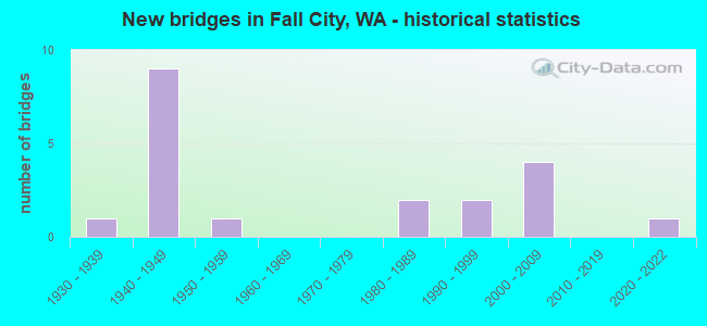
- New bridges - historical statistics
- 11930-1939
- 91940-1949
- 11950-1959
- 21980-1989
- 21990-1999
- 42000-2009
- 12020-2022


- Bridge Condition - Deck
- 15.8%Very good
- 36.8%Good
- 36.8%Satisfactory
- 5.3%Fair
- 5.3%Poor

- Bridge Condition - Superstructure
- 10.5%Very good
- 57.9%Good
- 26.3%Satisfactory
- 5.3%Fair

- Bridge Condition - Substructure
- 21.1%Very good
- 42.1%Good
- 21.1%Satisfactory
- 15.8%Fair

- Bridge Condition - Channel
- 80.0%Very good
- 10.0%Good
- 10.0%Satisfactory
Find on map >> Show street view
Structure Number: BK, Location: 3.0 N JCT SR 202 (Lat: 47.606333, Lng: -121.913917), Route carried "on" structure: State highway 203, Year Built: 1945, Status: Open, Structure Length: 1.58m (5.18ft), Average Daily Traffic: 7,783 (year 2019), Truck Traffic: 10%, Average Future Daily Traffic: 10,989 (year 2039), Features Intersected: CREEK
Minimum Vertical Clearance: 30+ m (98+ ft), Kilometerpoint: 4.828, Lanes on structure: 2, Base Highway Network: Yes, Owner: State Highway Agency, Approaching Roadway Width: 9.8m (32.2ft), Material/Design: Wood or Timber, Design/Construction: Stringer/Multi-beam, Number Of Spans In Main Unit: 3, Length of Maximum Span: 5.2m (17.1ft), Curb-To-Curb Width: 9.1m (29.9ft), Out-to-Out Width: 9.3m (30.5ft)
Condition: Deck: Fair, Superstructure: Good, Substructure: Satisfactory, Channel: Very good, Operating Rating: 34.5 metric tons, Method Used To Determine Operating Rating: Allowable Stress (AS), Inventory Rating: 22.7 metric tons, Method Used To Determine Inventory Rating: Allowable Stress (AS), Structural Evaluation: Somewhat better than minimum adequacy, Deck Geometry: High priority of corrective action, Waterway Adequacy: Equal to present minimum criteria, Approach Roadway Alignment: Equal to present desirable criteria, Length Of Structure Improvement: 1.58m (5.18ft), Designated Inspection Frequency: Every 24 months, Inspection Date: July 2021, Bridge Improvement Cost: $354,000, Roadway Improvement Cost: $71,000, Total Project Cost: $707,000 ( Estimate for 2014), Deck Structure Type: Wood or Timber, Wearing Surface/Protective System: Wearing Surface: Bituminous
Find on map >> Show street view
Structure Number: 1380A, Location: 11.5 E JCT SR 520 (Lat: 47.580000, Lng: -121.936667), Route carried "on" structure: State highway 202, Year Built: 1930, Status: Open, Structure Length: 1.28m (4.20ft), Average Daily Traffic: 7,905 (year 2019), Truck Traffic: 9%, Average Future Daily Traffic: 11,161 (year 2039), Design Load: H 15, Features Intersected: PATTERSON CREEK
Minimum Vertical Clearance: 30+ m (98+ ft), Kilometerpoint: 30.948, Lanes on structure: 2, Base Highway Network: Yes, Owner: State Highway Agency, Approaching Roadway Width: 9.8m (32.2ft), Material/Design: Concrete, Design/Construction: Tee Beam, Number Of Spans In Main Unit: 1, Length of Maximum Span: 12.5m (41.0ft), Curb-To-Curb Width: 8.5m (27.9ft), Out-to-Out Width: 8.8m (28.9ft)
Condition: Deck: Satisfactory, Superstructure: Good, Substructure: Good, Channel: Very good, Operating Rating: 41.7 metric tons, Method Used To Determine Operating Rating: Load Factor (LF), Inventory Rating: 24.5 metric tons, Method Used To Determine Inventory Rating: Load Factor (LF), Structural Evaluation: Equal to present minimum criteria, Deck Geometry: High priority of replacement, Waterway Adequacy: Equal to present minimum criteria, Approach Roadway Alignment: Equal to present desirable criteria, Length Of Structure Improvement: 1.28m (4.20ft), Designated Inspection Frequency: Every 24 months, Inspection Date: July 2021, Bridge Improvement Cost: $286,000, Roadway Improvement Cost: $57,000, Total Project Cost: $571,000 ( Estimate for 2014), Deck Structure Type: Concrete Cast-file-Place, Wearing Surface/Protective System: Wearing Surface: Bituminous, Membrane: Preformed Fabric
Find on map >> Show street view
Structure Number: 2999A, Location: 0.2 N JCT SR 202 (Lat: 47.572528, Lng: -121.887639), Route carried "on" structure: State highway 203, Year Built: 1945, Status: Open, Structure Length: 8.87m (29.10ft), Average Daily Traffic: 7,783 (year 2019), Truck Traffic: 10%, Average Future Daily Traffic: 10,989 (year 2039), Design Load: H 15, Features Intersected: SLOUGH
Minimum Vertical Clearance: 30+ m (98+ ft), Kilometerpoint: 0.386, Lanes on structure: 2, Base Highway Network: Yes, Owner: State Highway Agency, Approaching Roadway Width: 9.1m (29.9ft), Material/Design: Wood or Timber, Design/Construction: Stringer/Multi-beam, Number Of Spans In Main Unit: 17, Length of Maximum Span: 5.2m (17.1ft), Curb or Sidewalk Widths: Left: 0.1m (0.3ft), Right: 1.0m (3.3ft), Curb-To-Curb Width: 7.9m (25.9ft), Out-to-Out Width: 9.9m (32.5ft)
Condition: Deck: Satisfactory, Superstructure: Satisfactory, Substructure: Fair, Channel: Very good, Operating Rating: 43.5 metric tons, Method Used To Determine Operating Rating: Allowable Stress (AS), Inventory Rating: 29.9 metric tons, Method Used To Determine Inventory Rating: Allowable Stress (AS), Structural Evaluation: Somewhat better than minimum adequacy, Deck Geometry: High priority of corrective action, Waterway Adequacy: High priority of corrective action, Approach Roadway Alignment: Equal to present desirable criteria, Length Of Structure Improvement: 8.87m (29.10ft), Designated Inspection Frequency: Every 24 months, Inspection Date: July 2021, Bridge Improvement Cost: $1,862,000, Roadway Improvement Cost: $372,000, Total Project Cost: $3,725,000 ( Estimate for 2014), Deck Structure Type: Concrete Cast-file-Place, Wearing Surface/Protective System: Wearing Surface: Bituminous
Find on map >> Show street view
Structure Number: 2999B, Location: 0.5 N JCT SR 202 (Lat: 47.575500, Lng: -121.890444), Route carried "on" structure: State highway 203, Year Built: 1945, Status: Open, Structure Length: 1.58m (5.18ft), Average Daily Traffic: 7,783 (year 2019), Truck Traffic: 10%, Average Future Daily Traffic: 10,989 (year 2039), Design Load: H 15, Features Intersected: SLOUGH
Minimum Vertical Clearance: 30+ m (98+ ft), Kilometerpoint: 0.789, Lanes on structure: 2, Base Highway Network: Yes, Owner: State Highway Agency, Approaching Roadway Width: 9.1m (29.9ft), Material/Design: Wood or Timber, Design/Construction: Stringer/Multi-beam, Number Of Spans In Main Unit: 3, Length of Maximum Span: 5.2m (17.1ft), Curb-To-Curb Width: 11.0m (36.1ft), Out-to-Out Width: 11.8m (38.7ft)
Condition: Deck: Poor, Superstructure: Good, Substructure: Fair, Channel: Very good, Operating Rating: 44.4 metric tons, Method Used To Determine Operating Rating: Allowable Stress (AS), Inventory Rating: 30.8 metric tons, Method Used To Determine Inventory Rating: Allowable Stress (AS), Structural Evaluation: Somewhat better than minimum adequacy, Deck Geometry: Meets minimum limits, Waterway Adequacy: Equal to present minimum criteria, Approach Roadway Alignment: Equal to present desirable criteria, Length Of Structure Improvement: 1.58m (5.18ft), Designated Inspection Frequency: Every 24 months, Inspection Date: July 2021, Bridge Improvement Cost: $333,000, Roadway Improvement Cost: $67,000, Total Project Cost: $666,000 ( Estimate for 2014), Deck Structure Type: Concrete Cast-file-Place, Wearing Surface/Protective System: Wearing Surface: Monolithic Concrete
Find on map >> Show street view
Structure Number: 2999C, Location: 0.7 N JCT SR 202 (Lat: 47.577786, Lng: -121.892783), Route carried "on" structure: State highway 203, Year Built: 1945, Status: Open, Structure Length: 2.10m (6.89ft), Average Daily Traffic: 7,783 (year 2019), Truck Traffic: 10%, Average Future Daily Traffic: 10,989 (year 2039), Design Load: H 15, Features Intersected: SLOUGH
Minimum Vertical Clearance: 30+ m (98+ ft), Kilometerpoint: 1.078, Lanes on structure: 2, Base Highway Network: Yes, Owner: State Highway Agency, Approaching Roadway Width: 9.1m (29.9ft), Material/Design: Wood or Timber, Design/Construction: Stringer/Multi-beam, Number Of Spans In Main Unit: 4, Length of Maximum Span: 5.2m (17.1ft), Curb-To-Curb Width: 11.0m (36.1ft), Out-to-Out Width: 11.9m (39.0ft)
Condition: Deck: Satisfactory, Superstructure: Good, Substructure: Satisfactory, Channel: Very good, Operating Rating: 45.4 metric tons, Method Used To Determine Operating Rating: Allowable Stress (AS), Inventory Rating: 31.7 metric tons, Method Used To Determine Inventory Rating: Allowable Stress (AS), Structural Evaluation: Equal to present minimum criteria, Deck Geometry: Meets minimum limits, Waterway Adequacy: Equal to present minimum criteria, Approach Roadway Alignment: Equal to present desirable criteria, Length Of Structure Improvement: 2.10m (6.89ft), Designated Inspection Frequency: Every 24 months, Inspection Date: May 2018, Bridge Improvement Cost: $442,000, Roadway Improvement Cost: $88,000, Total Project Cost: $883,000 ( Estimate for 2014), Deck Structure Type: Concrete Cast-file-Place, Wearing Surface/Protective System: Wearing Surface: Monolithic Concrete
Find on map >> Show street view
Structure Number: 2999D, Location: 0.8 N JCT SR 202 (Lat: 47.578600, Lng: -121.893589), Route carried "on" structure: State highway 203, Year Built: 1945, Status: Open, Structure Length: 1.58m (5.18ft), Average Daily Traffic: 7,783 (year 2019), Truck Traffic: 10%, Average Future Daily Traffic: 10,989 (year 2039), Design Load: H 15, Features Intersected: SLOUGH
Minimum Vertical Clearance: 30+ m (98+ ft), Kilometerpoint: 1.207, Lanes on structure: 2, Base Highway Network: Yes, Owner: State Highway Agency, Approaching Roadway Width: 9.8m (32.2ft), Material/Design: Wood or Timber, Design/Construction: Stringer/Multi-beam, Number Of Spans In Main Unit: 3, Length of Maximum Span: 5.2m (17.1ft), Curb-To-Curb Width: 11.0m (36.1ft), Out-to-Out Width: 11.8m (38.7ft)
Condition: Deck: Satisfactory, Superstructure: Good, Substructure: Good, Channel: Satisfactory, Operating Rating: 44.4 metric tons, Method Used To Determine Operating Rating: Allowable Stress (AS), Inventory Rating: 30.8 metric tons, Method Used To Determine Inventory Rating: Allowable Stress (AS), Structural Evaluation: Better than present minimum criteria, Deck Geometry: Meets minimum limits, Waterway Adequacy: Equal to present minimum criteria, Approach Roadway Alignment: Equal to present desirable criteria, Length Of Structure Improvement: 1.58m (5.18ft), Designated Inspection Frequency: Every 24 months, Inspection Date: July 2021, Bridge Improvement Cost: $354,000, Roadway Improvement Cost: $71,000, Total Project Cost: $707,000 ( Estimate for 2014), Deck Structure Type: Concrete Cast-file-Place, Wearing Surface/Protective System: Wearing Surface: Monolithic Concrete
Find on map >> Show street view
Structure Number: 2999E, Location: 1.1 N JCT SR 202 (Lat: 47.582806, Lng: -121.897808), Route carried "on" structure: State highway 203, Year Built: 1945, Status: Open, Structure Length: 2.93m (9.61ft), Average Daily Traffic: 7,783 (year 2019), Truck Traffic: 10%, Average Future Daily Traffic: 10,989 (year 2039), Design Load: H 15, Features Intersected: SLOUGH
Minimum Vertical Clearance: 30+ m (98+ ft), Kilometerpoint: 1.754, Lanes on structure: 2, Base Highway Network: Yes, Owner: State Highway Agency, Approaching Roadway Width: 9.8m (32.2ft), Material/Design: Wood or Timber, Design/Construction: Stringer/Multi-beam, Number Of Spans In Main Unit: 5, Length of Maximum Span: 5.8m (19.0ft), Curb-To-Curb Width: 11.0m (36.1ft), Out-to-Out Width: 11.8m (38.7ft)
Condition: Deck: Satisfactory, Superstructure: Satisfactory, Substructure: Satisfactory, Channel: Very good, Operating Rating: 47.2 metric tons, Method Used To Determine Operating Rating: Allowable Stress (AS), Inventory Rating: 32.7 metric tons, Method Used To Determine Inventory Rating: Allowable Stress (AS), Structural Evaluation: Equal to present minimum criteria, Deck Geometry: Meets minimum limits, Waterway Adequacy: High priority of corrective action, Approach Roadway Alignment: Equal to present desirable criteria, Length Of Structure Improvement: 2.93m (9.61ft), Designated Inspection Frequency: Every 48 months, Inspection Date: September 2018, Bridge Improvement Cost: $653,000, Roadway Improvement Cost: $131,000, Total Project Cost: $1,306,000 ( Estimate for 2014), Deck Structure Type: Concrete Cast-file-Place, Wearing Surface/Protective System: Wearing Surface: Monolithic Concrete
Find on map >> Show street view
Structure Number: 2999F, Location: 1.2 N JCT SR 202 (Lat: 47.584583, Lng: -121.899603), Route carried "on" structure: State highway 203, Year Built: 1945, Status: Open, Structure Length: 2.10m (6.89ft), Average Daily Traffic: 7,783 (year 2019), Truck Traffic: 10%, Average Future Daily Traffic: 10,989 (year 2039), Design Load: H 15, Features Intersected: SLOUGH
Minimum Vertical Clearance: 30+ m (98+ ft), Kilometerpoint: 1.996, Lanes on structure: 2, Base Highway Network: Yes, Owner: State Highway Agency, Approaching Roadway Width: 11.0m (36.1ft), Material/Design: Wood or Timber, Design/Construction: Stringer/Multi-beam, Number Of Spans In Main Unit: 4, Length of Maximum Span: 5.5m (18.0ft), Curb-To-Curb Width: 11.0m (36.1ft), Out-to-Out Width: 11.9m (39.0ft)
Condition: Deck: Good, Superstructure: Satisfactory, Substructure: Satisfactory, Channel: Very good, Operating Rating: 44.4 metric tons, Method Used To Determine Operating Rating: Allowable Stress (AS), Inventory Rating: 30.8 metric tons, Method Used To Determine Inventory Rating: Allowable Stress (AS), Structural Evaluation: Equal to present minimum criteria, Deck Geometry: Meets minimum limits, Waterway Adequacy: Equal to present minimum criteria, Approach Roadway Alignment: Equal to present desirable criteria, Length Of Structure Improvement: 2.10m (6.89ft), Designated Inspection Frequency: Every 24 months, Inspection Date: May 2018, Bridge Improvement Cost: $524,000, Roadway Improvement Cost: $105,000, Total Project Cost: $1,049,000 ( Estimate for 2014), Deck Structure Type: Concrete Cast-file-Place, Wearing Surface/Protective System: Wearing Surface: Monolithic Concrete
Find on map >> Show street view
Structure Number: 2999G, Location: 1.4 N JCT SR 202 (Lat: 47.586164, Lng: -121.901217), Route carried "on" structure: State highway 203, Year Built: 1945, Status: Open, Structure Length: 2.10m (6.89ft), Average Daily Traffic: 7,783 (year 2019), Truck Traffic: 10%, Average Future Daily Traffic: 10,989 (year 2039), Design Load: H 15, Features Intersected: SLOUGH
Minimum Vertical Clearance: 30+ m (98+ ft), Kilometerpoint: 2.205, Lanes on structure: 2, Base Highway Network: Yes, Owner: State Highway Agency, Approaching Roadway Width: 9.8m (32.2ft), Material/Design: Wood or Timber, Design/Construction: Stringer/Multi-beam, Number Of Spans In Main Unit: 4, Length of Maximum Span: 5.2m (17.1ft), Curb-To-Curb Width: 11.0m (36.1ft), Out-to-Out Width: 11.8m (38.7ft)
Condition: Deck: Satisfactory, Superstructure: Good, Substructure: Good, Channel: Very good, Operating Rating: 44.4 metric tons, Method Used To Determine Operating Rating: Allowable Stress (AS), Inventory Rating: 30.8 metric tons, Method Used To Determine Inventory Rating: Allowable Stress (AS), Structural Evaluation: Better than present minimum criteria, Deck Geometry: Meets minimum limits, Waterway Adequacy: Equal to present minimum criteria, Approach Roadway Alignment: Equal to present desirable criteria, Length Of Structure Improvement: 2.10m (6.89ft), Designated Inspection Frequency: Every 48 months, Inspection Date: September 2018, Bridge Improvement Cost: $469,000, Roadway Improvement Cost: $94,000, Total Project Cost: $938,000 ( Estimate for 2014), Deck Structure Type: Concrete Cast-file-Place, Wearing Surface/Protective System: Wearing Surface: Monolithic Concrete
Find on map >> Show street view
Structure Number: 2999I, Location: 2.1 N JCT SR 202 (Lat: 47.594581, Lng: -121.910669), Route carried "on" structure: State highway 203, Year Built: 1945, Status: Open, Structure Length: 2.10m (6.89ft), Average Daily Traffic: 7,783 (year 2019), Truck Traffic: 10%, Average Future Daily Traffic: 10,989 (year 2039), Design Load: H 15, Features Intersected: SLOUGH
Minimum Vertical Clearance: 30+ m (98+ ft), Kilometerpoint: 3.380, Lanes on structure: 2, Base Highway Network: Yes, Owner: State Highway Agency, Approaching Roadway Width: 9.8m (32.2ft), Material/Design: Wood or Timber, Design/Construction: Stringer/Multi-beam, Number Of Spans In Main Unit: 4, Length of Maximum Span: 5.2m (17.1ft), Curb-To-Curb Width: 11.0m (36.1ft), Out-to-Out Width: 11.9m (39.0ft)
Condition: Deck: Good, Superstructure: Good, Substructure: Good, Channel: Very good, Operating Rating: 44.4 metric tons, Method Used To Determine Operating Rating: Allowable Stress (AS), Inventory Rating: 30.8 metric tons, Method Used To Determine Inventory Rating: Allowable Stress (AS), Structural Evaluation: Better than present minimum criteria, Deck Geometry: Meets minimum limits, Waterway Adequacy: High priority of corrective action, Approach Roadway Alignment: Equal to present desirable criteria, Length Of Structure Improvement: 2.10m (6.89ft), Designated Inspection Frequency: Every 24 months, Inspection Date: July 2021, Bridge Improvement Cost: $469,000, Roadway Improvement Cost: $94,000, Total Project Cost: $938,000 ( Estimate for 2014), Deck Structure Type: Concrete Cast-file-Place, Wearing Surface/Protective System: Wearing Surface: Monolithic Concrete
Find on map >> Show street view
Structure Number: 11599A, Location: 14.0 E JCT SR 520 (Lat: 47.567861, Lng: -121.887611), Route carried "on" structure: State highway 202, Year Built: 1980, Status: Open, Structure Length: 12.77m (41.90ft), Average Daily Traffic: 12,633 (year 2019), Truck Traffic: 9%, Average Future Daily Traffic: 17,837 (year 2039), Design Load: HS 20+Mod, Features Intersected: SNOQUALMIE RIVER
Minimum Vertical Clearance: 30+ m (98+ ft), Kilometerpoint: 34.987, Lanes on structure: 3, Base Highway Network: Yes, Owner: State Highway Agency, Approaching Roadway Width: 18.3m (60.0ft), Skew: 3 degrees, Material/Design: Steel continuous, Design/Construction: Stringer/Multi-beam, Number Of Spans In Main Unit: 3, Length of Maximum Span: 48.8m (160.1ft), Curb or Sidewalk Widths: Left: 1.7m (5.6ft), Right: 0.0m, Curb-To-Curb Width: 15.8m (51.8ft), Out-to-Out Width: 19.1m (62.7ft)
Condition: Deck: Good, Superstructure: Satisfactory, Substructure: Good, Channel: Good, Operating Rating: 53.5 metric tons, Method Used To Determine Operating Rating: Load Factor (LF), Inventory Rating: 31.7 metric tons, Method Used To Determine Inventory Rating: Load Factor (LF), Structural Evaluation: Equal to present minimum criteria, Deck Geometry: Better than present minimum criteria, Waterway Adequacy: Better than present minimum criteria, Approach Roadway Alignment: Equal to present minimum criteria, Length Of Structure Improvement: 12.77m (41.90ft), Designated Inspection Frequency: Every 24 months, Underwater Inspection Frequency: Every 60 months, Inspection Date: August 2018, Underwater Inspection Date: September 2020, Bridge Improvement Cost: $5,196,000, Roadway Improvement Cost: $1,039,000, Total Project Cost: $10,391,000 ( Estimate for 2014), Deck Structure Type: Concrete Cast-file-Place, Wearing Surface/Protective System: Wearing Surface: Bituminous, Membrane: Preformed Fabric
Find on map >> Show street view
Structure Number: 12947A, Location: 1.8 N JCT SR 202 (Lat: 47.590806, Lng: -121.905833), Route carried "on" structure: State highway 203, Year Built: 1986, Status: Open, Structure Length: 6.40m (21.00ft), Average Daily Traffic: 7,783 (year 2019), Truck Traffic: 10%, Average Future Daily Traffic: 10,989 (year 2039), Design Load: HS 20+Mod, Features Intersected: SLOUGH
Minimum Vertical Clearance: 30+ m (98+ ft), Kilometerpoint: 2.865, Lanes on structure: 2, Base Highway Network: Yes, Owner: State Highway Agency, Approaching Roadway Width: 9.8m (32.2ft), Material/Design: Prestressed concrete, Design/Construction: Slab, Number Of Spans In Main Unit: 5, Length of Maximum Span: 12.8m (42.0ft), Curb-To-Curb Width: 10.1m (33.1ft), Out-to-Out Width: 11.0m (36.1ft)
Condition: Deck: Very good, Superstructure: Good, Substructure: Good, Channel: Very good, Operating Rating: 82.5 metric tons, Method Used To Determine Operating Rating: Load Factor (LF), Inventory Rating: 49.9 metric tons, Method Used To Determine Inventory Rating: Load Factor (LF), Structural Evaluation: Better than present minimum criteria, Deck Geometry: Meets minimum limits, Waterway Adequacy: High priority of corrective action, Approach Roadway Alignment: Equal to present desirable criteria, Length Of Structure Improvement: 6.40m (21.00ft), Designated Inspection Frequency: Every 48 months, Inspection Date: August 2018, Bridge Improvement Cost: $1,428,000, Roadway Improvement Cost: $286,000, Total Project Cost: $2,856,000 ( Estimate for 2014), Deck Structure Type: Concrete Precast Panels, Wearing Surface/Protective System: Wearing Surface: Bituminous, Membrane: Preformed Fabric
Find on map >> Show street view
Structure Number: 19269C, Location: 12.1 E JCT SR 520 (Lat: 47.577603, Lng: -121.925611), Route carried "on" structure: State highway 202, Year Built: 2020, Status: Open, Structure Length: 0.73m (2.40ft), Average Daily Traffic: 12,172 (year 2016), Truck Traffic: 8%, Average Future Daily Traffic: 19,062 (year 2038), Design Load: HL 93, Features Intersected: PATTERSON CRK EAST TRIB
Minimum Vertical Clearance: 30+ m (98+ ft), Kilometerpoint: 31.801, Lanes on structure: 2, Owner: State Highway Agency, Approaching Roadway Width: 10.4m (34.1ft), Material/Design: Concrete, Design/Construction: Culvert, Number Of Spans In Main Unit: 1, Length of Maximum Span: 7.3m (24.0ft)
Condition: Channel: Very good, Culverts: Very good, Operating Rating: 72.9 metric tons, Method Used To Determine Operating Rating: Load and Resistance Factor Rating (LRFR) rating reported by rating factor(RF) method using HL-93 loadings, Inventory Rating: 56.1 metric tons, Method Used To Determine Inventory Rating: Load and Resistance Factor Rating (LRFR) rating reported by rating factor(RF) method using HL-93 loadings, Structural Evaluation: Equal to present desirable criteria, Waterway Adequacy: Equal to present desirable criteria, Approach Roadway Alignment: Equal to present desirable criteria, Length Of Structure Improvement: 0.73m (2.40ft), Designated Inspection Frequency: Every 24 months, Inspection Date: November 2020, Bridge Improvement Cost: $173,000, Roadway Improvement Cost: $35,000, Total Project Cost: $346,000 ( Estimate for 2014)
Find on map >> Show street view
Structure Number: 80714, Location: 0.1 MI S OF SR-202 (Lat: 47.581750, Lng: -121.942778), Route carried "on" structure: County highway 83510, Year Built: 1951, Year Reconstructed: 1973, Status: Open, Structure Length: 0.64m (2.10ft), Average Daily Traffic: 10 (year 2019), Truck Traffic: 10%, Average Future Daily Traffic: 120 (year 2039), Design Load: H 15, Features Intersected: PATTERSON CREEK, Facility Carried by Structure: 300TH AVE SE
Minimum Vertical Clearance: 30+ m (98+ ft), Kilometerpoint: 0.001, Lanes on structure: 1, Owner: County Highway Agency, Approaching Roadway Width: 4.9m (16.1ft), Skew: 3 degrees, Material/Design: Wood or Timber, Design/Construction: Stringer/Multi-beam, Number Of Spans In Main Unit: 1, Length of Maximum Span: 6.1m (20.0ft), Curb-To-Curb Width: 5.8m (19.0ft), Out-to-Out Width: 6.1m (20.0ft)
Condition: Deck: Satisfactory, Superstructure: Satisfactory, Substructure: Fair, Channel: Satisfactory, Operating Rating: 35.4 metric tons, Method Used To Determine Operating Rating: Allowable Stress (AS), Inventory Rating: 25.4 metric tons, Method Used To Determine Inventory Rating: Allowable Stress (AS), Structural Evaluation: Somewhat better than minimum adequacy, Deck Geometry: Meets minimum limits, Waterway Adequacy: Equal to present minimum criteria, Approach Roadway Alignment: Equal to present minimum criteria, Length Of Structure Improvement: 0.94m (3.08ft), Designated Inspection Frequency: Every 24 months, Inspection Date: August 2019, Bridge Improvement Cost: $322,000, Roadway Improvement Cost: $64,000, Total Project Cost: $645,000 ( Estimate for 2014), Deck Structure Type: Wood or Timber, Wearing Surface/Protective System: Wearing Surface: Bituminous
Find on map >> Show street view
Structure Number: 8638, Location: 300 FT N OF FALL CITY RD (Lat: 47.554456, Lng: -121.900222), Route carried "on" structure: County highway 83010, Year Built: 1998, Status: Open, Structure Length: 3.81m (12.50ft), Average Daily Traffic: 1,563 (year 2019), Truck Traffic: 2%, Average Future Daily Traffic: 2,825 (year 2039), Design Load: HS 25 or greater, Features Intersected: RAGING RIVER, Facility Carried by Structure: 328 WAY SE
Minimum Vertical Clearance: 5.03m (16.50ft), Kilometerpoint: 0.001, Lanes on structure: 2, Owner: County Highway Agency, Approaching Roadway Width: 10.4m (34.1ft), Material/Design: Steel, Design/Construction: Truss - Thru, Number Of Spans In Main Unit: 1, Length of Maximum Span: 36.6m (120.1ft), Curb-To-Curb Width: 10.4m (34.1ft), Out-to-Out Width: 11.6m (38.1ft)
Condition: Deck: Good, Superstructure: Good, Substructure: Very good, Channel: Good, Operating Rating: 27.5 metric tons, Method Used To Determine Operating Rating: Load and Resistance Factor Rating (LRFR) rating reported by rating factor(RF) method using HL-93 loadings, Inventory Rating: 16.5 metric tons, Method Used To Determine Inventory Rating: Load and Resistance Factor Rating (LRFR) rating reported by rating factor(RF) method using HL-93 loadings, Structural Evaluation: Meets minimum limits, Deck Geometry: Equal to present minimum criteria, Waterway Adequacy: Equal to present desirable criteria, Approach Roadway Alignment: Equal to present desirable criteria, Length Of Structure Improvement: 3.81m (12.50ft), Designated Inspection Frequency: Every 24 months, Critical Feature Inspection Frequency: Every 24 months, Inspection Date: April 2021, Critical Feature Inspection Date: April 2021, Bridge Improvement Cost: $900,000, Roadway Improvement Cost: $180,000, Total Project Cost: $1,800,000 ( Estimate for 2014), Deck Structure Type: Concrete Cast-file-Place, Wearing Surface/Protective System: Wearing Surface: Monolithic Concrete, Deck Protection: Epoxy Coated Reinforcing
Find on map >> Show street view
Structure Number: 86442, Location: 0.25 MI S OF SR-202 (Lat: 47.564111, Lng: -121.889472), Route carried "on" structure: County highway 98906, Year Built: 1998, Status: Open, Structure Length: 6.07m (19.91ft), Average Daily Traffic: 9,092 (year 2019), Truck Traffic: 5%, Average Future Daily Traffic: 12,500 (year 2039), Design Load: HS 25 or greater, Features Intersected: RAGING RIVER, Facility Carried by Structure: PRESTON FALL CITY
Minimum Vertical Clearance: 30+ m (98+ ft), Kilometerpoint: 0.001, Lanes on structure: 2, Owner: County Highway Agency, Approaching Roadway Width: 12.2m (40.0ft), Skew: 3 degrees, Material/Design: Prestressed concrete continuous, Design/Construction: Stringer/Multi-beam, Number Of Spans In Main Unit: 1, Number Of Approach Spans: 1, Length of Maximum Span: 35.7m (117.1ft), Curb or Sidewalk Widths: Left: 1.9m (6.2ft), Right: 0.0m, Curb-To-Curb Width: 12.2m (40.0ft), Out-to-Out Width: 14.7m (48.2ft)
Condition: Deck: Good, Superstructure: Fair, Substructure: Good, Channel: Very good, Operating Rating: 24.3 metric tons, Method Used To Determine Operating Rating: Load and Resistance Factor Rating (LRFR) rating reported by rating factor(RF) method using HL-93 loadings, Inventory Rating: 18.8 metric tons, Method Used To Determine Inventory Rating: Load and Resistance Factor Rating (LRFR) rating reported by rating factor(RF) method using HL-93 loadings, Structural Evaluation: Meets minimum limits, Deck Geometry: Somewhat better than minimum adequacy, Waterway Adequacy: Equal to present desirable criteria, Approach Roadway Alignment: Equal to present desirable criteria, Length Of Structure Improvement: 6.07m (19.91ft), Designated Inspection Frequency: Every 24 months, Inspection Date: April 2021, Bridge Improvement Cost: $1,672,000, Roadway Improvement Cost: $334,000, Total Project Cost: $3,343,000 ( Estimate for 2014), Deck Structure Type: Concrete Cast-file-Place, Wearing Surface/Protective System: Wearing Surface: Monolithic Concrete, Deck Protection: Epoxy Coated Reinforcing
Find on map >> Show street view
Structure Number: 87564, Location: 0.3 MI W OF SR-203 (Lat: 47.574850, Lng: -121.890908), Route carried "on" structure: County highway 88010, Year Built: 2007, Status: Open, Structure Length: 0.98m (3.22ft), Average Daily Traffic: 150 (year 2019), Truck Traffic: 5%, Average Future Daily Traffic: 300 (year 2039), Design Load: HS 25 or greater, Features Intersected: DRAINAGE DITCH, Facility Carried by Structure: CW NEAL ROAD
Minimum Vertical Clearance: 30+ m (98+ ft), Kilometerpoint: 0.001, Lanes on structure: 2, Owner: County Highway Agency, Approaching Roadway Width: 8.5m (27.9ft), Material/Design: Concrete, Design/Construction: Frame, Number Of Spans In Main Unit: 1, Length of Maximum Span: 9.1m (29.9ft), Curb-To-Curb Width: 7.5m (24.6ft), Out-to-Out Width: 7.6m (24.9ft)
Condition: Deck: Very good, Superstructure: Very good, Substructure: Very good, Channel: Very good, Operating Rating: 65.3 metric tons, Method Used To Determine Operating Rating: Load and Resistance Factor (LRFR), Inventory Rating: 39.0 metric tons, Method Used To Determine Inventory Rating: Load and Resistance Factor (LRFR), Structural Evaluation: Equal to present desirable criteria, Deck Geometry: Somewhat better than minimum adequacy, Waterway Adequacy: Better than present minimum criteria, Approach Roadway Alignment: Equal to present desirable criteria, Length Of Structure Improvement: 1.28m (4.20ft), Designated Inspection Frequency: Every 24 months, Inspection Date: July 2021, Bridge Improvement Cost: $638,000, Roadway Improvement Cost: $128,000, Total Project Cost: $1,277,000 ( Estimate for 2014), Deck Structure Type: Concrete Precast Panels, Wearing Surface/Protective System: Wearing Surface: Bituminous, Deck Protection: Epoxy Coated Reinforcing
Find on map >> Show street view
Structure Number: 87565, Location: 0.4 MI NE OF SR-203 (Lat: 47.574747, Lng: -121.882814), Route carried "on" structure: County highway 88000, Year Built: 2007, Status: Open, Structure Length: 0.94m (3.08ft), Average Daily Traffic: 95 (year 2019), Truck Traffic: 5%, Average Future Daily Traffic: 300 (year 2039), Design Load: HS 20, Features Intersected: RUTHERFORD SLOUGH, Facility Carried by Structure: SE 39TH PL
Minimum Vertical Clearance: 30+ m (98+ ft), Kilometerpoint: 0.001, Lanes on structure: 2, Owner: County Highway Agency, Approaching Roadway Width: 8.5m (27.9ft), Skew: 2 degrees, Material/Design: Concrete, Design/Construction: Frame, Number Of Spans In Main Unit: 1, Length of Maximum Span: 9.1m (29.9ft), Curb or Sidewalk Widths: Left: 0.3m (1.0ft), Right: 0.3m (1.0ft), Curb-To-Curb Width: 7.4m (24.3ft), Out-to-Out Width: 7.7m (25.3ft)
Condition: Deck: Good, Superstructure: Good, Substructure: Good, Channel: Very good, Operating Rating: 68.0 metric tons, Method Used To Determine Operating Rating: Load and Resistance Factor (LRFR), Inventory Rating: 40.8 metric tons, Method Used To Determine Inventory Rating: Load and Resistance Factor (LRFR), Structural Evaluation: Better than present minimum criteria, Deck Geometry: Equal to present minimum criteria, Waterway Adequacy: Better than present minimum criteria, Approach Roadway Alignment: Equal to present desirable criteria, Length Of Structure Improvement: 1.25m (4.10ft), Designated Inspection Frequency: Every 24 months, Inspection Date: July 2021, Bridge Improvement Cost: $623,000, Roadway Improvement Cost: $125,000, Total Project Cost: $1,246,000 ( Estimate for 2014), Deck Structure Type: Other, Wearing Surface/Protective System: Wearing Surface: Bituminous, Deck Protection: Epoxy Coated Reinforcing
Find on map >> Show street view
Structure Number: 87795, Location: 0.8 MI N OF SR-202 (Lat: 47.587206, Lng: -121.929169), Route carried "on" structure: County highway 67950, Year Built: 2008, Status: Open, Structure Length: 1.13m (3.71ft), Average Daily Traffic: 338 (year 2020), Truck Traffic: 2%, Average Future Daily Traffic: 400 (year 2040), Design Load: HL 93, Features Intersected: PATTERSON CREEK, Facility Carried by Structure: 310TH AVE SE
Minimum Vertical Clearance: 30+ m (98+ ft), Kilometerpoint: 0.001, Lanes on structure: 2, Owner: County Highway Agency, Approaching Roadway Width: 6.1m (20.0ft), Material/Design: Prestressed concrete, Design/Construction: Slab, Number Of Spans In Main Unit: 1, Length of Maximum Span: 10.7m (35.1ft), Curb-To-Curb Width: 7.2m (23.6ft), Out-to-Out Width: 7.3m (24.0ft)
Condition: Deck: Good, Superstructure: Good, Substructure: Very good, Channel: Very good, Operating Rating: 76.2 metric tons, Method Used To Determine Operating Rating: Load and Resistance Factor (LRFR), Inventory Rating: 45.4 metric tons, Method Used To Determine Inventory Rating: Load and Resistance Factor (LRFR), Structural Evaluation: Better than present minimum criteria, Deck Geometry: Meets minimum limits, Waterway Adequacy: Better than present minimum criteria, Approach Roadway Alignment: Equal to present desirable criteria, Length Of Structure Improvement: 1.43m (4.69ft), Designated Inspection Frequency: Every 24 months, Inspection Date: September 2020, Bridge Improvement Cost: $714,000, Roadway Improvement Cost: $143,000, Total Project Cost: $1,429,000 ( Estimate for 2014), Deck Structure Type: Concrete Precast Panels, Wearing Surface/Protective System: Wearing Surface: Bituminous, Deck Protection: Epoxy Coated Reinforcing
Find on map >> Show street view
Structure Number: 87798, Location: 0.2 MI NO OF SR-202 (Lat: 47.580833, Lng: -121.931917), Route carried "on" structure: County highway 67990, Year Built: 2008, Status: Open, Structure Length: 1.01m (3.31ft), Average Daily Traffic: 300 (year 2020), Truck Traffic: 2%, Average Future Daily Traffic: 400 (year 2040), Design Load: HL 93, Features Intersected: PATTERSON CREEK, Facility Carried by Structure: 308TH AVE SE
Minimum Vertical Clearance: 30+ m (98+ ft), Kilometerpoint: 0.001, Lanes on structure: 2, Owner: County Highway Agency, Approaching Roadway Width: 6.1m (20.0ft), Material/Design: Prestressed concrete, Design/Construction: Slab, Number Of Spans In Main Unit: 1, Length of Maximum Span: 9.4m (30.8ft), Curb-To-Curb Width: 7.2m (23.6ft), Out-to-Out Width: 7.3m (24.0ft)
Condition: Deck: Very good, Superstructure: Very good, Substructure: Very good, Channel: Very good, Operating Rating: 84.4 metric tons, Method Used To Determine Operating Rating: Load and Resistance Factor (LRFR), Inventory Rating: 49.9 metric tons, Method Used To Determine Inventory Rating: Load and Resistance Factor (LRFR), Structural Evaluation: Equal to present desirable criteria, Deck Geometry: Meets minimum limits, Waterway Adequacy: Equal to present minimum criteria, Approach Roadway Alignment: Equal to present desirable criteria, Length Of Structure Improvement: 1.31m (4.30ft), Designated Inspection Frequency: Every 24 months, Inspection Date: September 2020, Bridge Improvement Cost: $654,000, Roadway Improvement Cost: $131,000, Total Project Cost: $1,307,000 ( Estimate for 2014), Deck Structure Type: Concrete Precast Panels, Wearing Surface/Protective System: Wearing Surface: Bituminous, Deck Protection: Epoxy Coated Reinforcing