Bridge Statistics for Falls Creek, Pennsylvania (PA)
Condition, Traffic, Stress, Structural Evaluation, Project Costs
- National Bridge Inventory (NBI) Statistics
- 17Number of bridges
- 154ft / 47.2mTotal length
- $4,089,000Total costs
- 153,341Total average daily traffic
- 61,374Total average daily truck traffic
- National Bridge Inventory (NBI) Registered Bridges for Falls Creek
- No street view available for this location
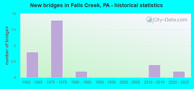
- New bridges - historical statistics
- 41960-1969
- 91970-1979
- 11980-1989
- 22010-2019
- 12020-2022


- Bridge Condition - Deck
- 12.5%Very good
- 12.5%Good
- 75.0%Satisfactory

- Bridge Condition - Superstructure
- 11.1%Very good
- 11.1%Good
- 55.6%Satisfactory
- 22.2%Fair

- Bridge Condition - Substructure
- 22.2%Very good
- 44.4%Satisfactory
- 33.3%Fair

- Bridge Condition - Channel
- 55.6%Satisfactory
- 22.2%Fair
- 22.2%Poor

- Bridge Condition - Culverts
- 25.0%Good
- 25.0%Satisfactory
- 50.0%Fair
Find on map >> Show street view
Structure Number: 19594, Location: SMITHTOWN NO.1 (Lat: 41.149125, Lng: -78.854947), Route carried "on" structure: Interstate 80, Year Built: 1964, Status: Open, Structure Length: 3.32m (10.89ft), Average Daily Traffic: 14,298 (year 2021), Truck Traffic: 41%, Average Future Daily Traffic: 19,543 (year 2032), Design Load: HS 20+Mod, Features Intersected: SR1004
Minimum Vertical Clearance: 30+ m (98+ ft), Kilometerpoint: 32.436, Lanes on structure: 2, Lanes under structure: 2, Base Highway Network: Yes, Owner: State Highway Agency, Approaching Roadway Width: 11.6m (38.1ft), Skew: 13 degrees, Material/Design: Prestressed concrete, Design/Construction: Box Beam or Girders - Single/Spread, Number Of Spans In Main Unit: 3, Length of Maximum Span: 12.8m (42.0ft), Curb or Sidewalk Widths: Left: 0.2m (0.7ft), Right: 0.2m (0.7ft), Curb-To-Curb Width: 12.8m (42.0ft), Out-to-Out Width: 13.9m (45.6ft)
Condition: Deck: Satisfactory, Superstructure: Satisfactory, Substructure: Satisfactory, Operating Rating: 51.7 metric tons, Method Used To Determine Operating Rating: Load Factor (LF), Inventory Rating: 30.8 metric tons, Method Used To Determine Inventory Rating: Load Factor (LF), Structural Evaluation: Equal to present minimum criteria, Deck Geometry: Equal to present desirable criteria, Underclear: Meets minimum limits, Approach Roadway Alignment: Equal to present desirable criteria, Length Of Structure Improvement: 4.10m (13.45ft), Designated Inspection Frequency: Every 24 months, Inspection Date: August 2020, Deck Structure Type: Concrete Cast-file-Place, Wearing Surface/Protective System: Wearing Surface: Epoxy Overlay, Membrane: Epoxy, Deck Protection: Epoxy Coated Reinforcing
Find on map >> Show street view
Structure Number: 19596, Location: SMITHTOWN NO.2 (Lat: 41.149625, Lng: -78.855422), Route carried "on" structure: Interstate 80, Year Built: 1964, Status: Open, Structure Length: 3.26m (10.70ft), Average Daily Traffic: 15,086 (year 2021), Truck Traffic: 42%, Average Future Daily Traffic: 17,882 (year 2032), Design Load: HS 20+Mod, Features Intersected: SR1004
Minimum Vertical Clearance: 30+ m (98+ ft), Kilometerpoint: 31.991, Lanes on structure: 2, Lanes under structure: 2, Base Highway Network: Yes, Owner: State Highway Agency, Approaching Roadway Width: 11.6m (38.1ft), Skew: 13 degrees, Material/Design: Prestressed concrete, Design/Construction: Box Beam or Girders - Single/Spread, Number Of Spans In Main Unit: 3, Length of Maximum Span: 12.5m (41.0ft), Curb or Sidewalk Widths: Left: 0.2m (0.7ft), Right: 0.2m (0.7ft), Curb-To-Curb Width: 12.8m (42.0ft), Out-to-Out Width: 13.9m (45.6ft)
Condition: Deck: Satisfactory, Superstructure: Satisfactory, Substructure: Satisfactory, Operating Rating: 52.6 metric tons, Method Used To Determine Operating Rating: Load Factor (LF), Inventory Rating: 30.8 metric tons, Method Used To Determine Inventory Rating: Load Factor (LF), Structural Evaluation: Equal to present minimum criteria, Deck Geometry: Equal to present desirable criteria, Underclear: Meets minimum limits, Approach Roadway Alignment: Equal to present desirable criteria, Length Of Structure Improvement: 4.10m (13.45ft), Designated Inspection Frequency: Every 24 months, Inspection Date: August 2020, Deck Structure Type: Concrete Cast-file-Place, Wearing Surface/Protective System: Wearing Surface: Epoxy Overlay, Membrane: Epoxy, Deck Protection: Epoxy Coated Reinforcing
Find on map >> Show street view
Structure Number: 19598, Location: RED MILL NO.1 (Lat: 41.157381, Lng: -78.831133), Route carried "on" structure: Interstate 80, Year Built: 1970, Status: Open, Structure Length: 0.61m (2.00ft), Average Daily Traffic: 14,298 (year 2021), Truck Traffic: 41%, Average Future Daily Traffic: 19,543 (year 2032), Design Load: HS 20, Features Intersected: FALLS CREEK
Minimum Vertical Clearance: 30+ m (98+ ft), Kilometerpoint: 34.831, Lanes on structure: 2, Base Highway Network: Yes, Owner: State Highway Agency, Approaching Roadway Width: 11.6m (38.1ft), Skew: 20 degrees, Material/Design: Concrete, Design/Construction: Culvert, Number Of Spans In Main Unit: 1, Length of Maximum Span: 6.1m (20.0ft)
Condition: Channel: Fair, Culverts: Fair, Operating Rating: 46.3 metric tons, Method Used To Determine Operating Rating: Field evaluation and documented engineering judgment, Inventory Rating: 28.1 metric tons, Method Used To Determine Inventory Rating: Field evaluation and documented engineering judgment, Structural Evaluation: Somewhat better than minimum adequacy, Waterway Adequacy: Superior to present desirable criteria, Approach Roadway Alignment: Equal to present desirable criteria, Length Of Structure Improvement: 1.20m (3.94ft), Designated Inspection Frequency: Every 24 months, Inspection Date: July 2020
Find on map >> Show street view
Structure Number: 19599, Location: RED MILL NO.3 (Lat: 41.157844, Lng: -78.828031), Route carried "on" structure: Interstate 80, Year Built: 1970, Status: Open, Structure Length: 0.67m (2.20ft), Average Daily Traffic: 14,298 (year 2021), Truck Traffic: 41%, Average Future Daily Traffic: 19,543 (year 2032), Design Load: HS 20, Features Intersected: BEAVERDAM RUN
Minimum Vertical Clearance: 30+ m (98+ ft), Kilometerpoint: 34.831, Lanes on structure: 2, Base Highway Network: Yes, Owner: State Highway Agency, Approaching Roadway Width: 11.6m (38.1ft), Skew: 22 degrees, Material/Design: Concrete, Design/Construction: Culvert, Number Of Spans In Main Unit: 1, Length of Maximum Span: 6.7m (22.0ft)
Condition: Channel: Poor, Culverts: Satisfactory, Operating Rating: 49.0 metric tons, Method Used To Determine Operating Rating: Field evaluation and documented engineering judgment, Inventory Rating: 32.7 metric tons, Method Used To Determine Inventory Rating: Field evaluation and documented engineering judgment, Structural Evaluation: Equal to present minimum criteria, Waterway Adequacy: Superior to present desirable criteria, Approach Roadway Alignment: Equal to present desirable criteria, Length Of Structure Improvement: 1.30m (4.27ft), Designated Inspection Frequency: Every 48 months, Inspection Date: July 2018
Find on map >> Show street view
Structure Number: 19601, Location: RED MILL NO.4 (Lat: 41.158900, Lng: -78.827381), Route carried "on" structure: Interstate 80, Year Built: 1970, Status: Open, Structure Length: 0.73m (2.40ft), Average Daily Traffic: 15,086 (year 2021), Truck Traffic: 42%, Average Future Daily Traffic: 17,882 (year 2032), Design Load: HS 20, Features Intersected: BEAVERDAM RUN
Minimum Vertical Clearance: 30+ m (98+ ft), Kilometerpoint: 34.380, Lanes on structure: 2, Base Highway Network: Yes, Owner: State Highway Agency, Approaching Roadway Width: 11.6m (38.1ft), Skew: 23 degrees, Material/Design: Concrete, Design/Construction: Culvert, Number Of Spans In Main Unit: 1, Length of Maximum Span: 7.3m (24.0ft)
Condition: Channel: Poor, Culverts: Fair, Operating Rating: 46.3 metric tons, Method Used To Determine Operating Rating: Field evaluation and documented engineering judgment, Inventory Rating: 28.1 metric tons, Method Used To Determine Inventory Rating: Field evaluation and documented engineering judgment, Structural Evaluation: Somewhat better than minimum adequacy, Waterway Adequacy: Superior to present desirable criteria, Approach Roadway Alignment: Equal to present desirable criteria, Length Of Structure Improvement: 1.40m (4.59ft), Designated Inspection Frequency: Every 24 months, Inspection Date: July 2020
Find on map >> Show street view
Structure Number: 19604, Location: WOLF RUN NO.1 (Lat: 41.150214, Lng: -78.799783), Route carried "on" structure: Interstate 80, Year Built: 1970, Status: Open, Structure Length: 10.79m (35.40ft), Average Daily Traffic: 14,298 (year 2021), Truck Traffic: 41%, Average Future Daily Traffic: 19,543 (year 2032), Design Load: HS 20+Mod, Features Intersected: BUFF & PITT RR; WOLF RUN
Minimum Vertical Clearance: 30+ m (98+ ft), Kilometerpoint: 37.232, Lanes on structure: 2, Base Highway Network: Yes, Owner: State Highway Agency, Approaching Roadway Width: 11.6m (38.1ft), Skew: 10 degrees, Material/Design: Prestressed concrete, Design/Construction: Stringer/Multi-beam, Number Of Spans In Main Unit: 5, Length of Maximum Span: 25.6m (84.0ft), Curb or Sidewalk Widths: Left: 0.2m (0.7ft), Right: 0.2m (0.7ft), Curb-To-Curb Width: 10.3m (33.8ft), Out-to-Out Width: 11.1m (36.4ft)
Condition: Deck: Satisfactory, Superstructure: Fair, Substructure: Fair, Channel: Satisfactory, Operating Rating: 78.9 metric tons, Method Used To Determine Operating Rating: Load Factor (LF), Inventory Rating: 21.8 metric tons, Method Used To Determine Inventory Rating: Load Factor (LF), Structural Evaluation: Somewhat better than minimum adequacy, Deck Geometry: Meets minimum limits, Underclear: High priority of corrective action, Waterway Adequacy: Superior to present desirable criteria, Approach Roadway Alignment: Equal to present desirable criteria, Length Of Structure Improvement: 11.70m (38.39ft), Designated Inspection Frequency: Every 24 months, Inspection Date: January 2020, Bridge Improvement Cost: $61,000, Roadway Improvement Cost: $181,000, Total Project Cost: $828,000, Deck Structure Type: Concrete Cast-file-Place, Wearing Surface/Protective System: Wearing Surface: Epoxy Overlay, Membrane: Epoxy, Deck Protection: Epoxy Coated Reinforcing
Find on map >> Show street view
Structure Number: 19605, Location: WOLF RUN NO.2 (Lat: 41.150722, Lng: -78.800300), Route carried "on" structure: Interstate 80, Year Built: 1970, Status: Open, Structure Length: 10.79m (35.40ft), Average Daily Traffic: 15,086 (year 2021), Truck Traffic: 42%, Average Future Daily Traffic: 17,882 (year 2032), Design Load: HS 20+Mod, Features Intersected: BUFF & PITT RR; WOLF RUN
Minimum Vertical Clearance: 30+ m (98+ ft), Kilometerpoint: 36.971, Lanes on structure: 2, Base Highway Network: Yes, Owner: State Highway Agency, Approaching Roadway Width: 11.6m (38.1ft), Skew: 10 degrees, Material/Design: Prestressed concrete, Design/Construction: Stringer/Multi-beam, Number Of Spans In Main Unit: 5, Length of Maximum Span: 25.9m (85.0ft), Curb or Sidewalk Widths: Left: 0.2m (0.7ft), Right: 0.2m (0.7ft), Curb-To-Curb Width: 10.3m (33.8ft), Out-to-Out Width: 11.1m (36.4ft)
Condition: Deck: Satisfactory, Superstructure: Fair, Substructure: Fair, Channel: Satisfactory, Operating Rating: 78.9 metric tons, Method Used To Determine Operating Rating: Load Factor (LF), Inventory Rating: 21.8 metric tons, Method Used To Determine Inventory Rating: Load Factor (LF), Structural Evaluation: Somewhat better than minimum adequacy, Deck Geometry: Meets minimum limits, Underclear: High priority of corrective action, Waterway Adequacy: Superior to present desirable criteria, Approach Roadway Alignment: Equal to present desirable criteria, Length Of Structure Improvement: 11.70m (38.39ft), Designated Inspection Frequency: Every 24 months, Inspection Date: January 2020, Bridge Improvement Cost: $61,000, Roadway Improvement Cost: $181,000, Total Project Cost: $828,000, Deck Structure Type: Concrete Cast-file-Place, Wearing Surface/Protective System: Wearing Surface: Epoxy Overlay, Membrane: Epoxy, Deck Protection: Epoxy Coated Reinforcing
Find on map >> Show street view
Structure Number: 19607, Location: TRIANGLE TECH WB (Lat: 41.149525, Lng: -78.796272), Route carried "on" structure: Interstate 80, Year Built: 1970, Year Reconstructed: 2014, Status: Open, Structure Length: 5.30m (17.39ft), Average Daily Traffic: 15,086 (year 2021), Truck Traffic: 42%, Average Future Daily Traffic: 17,882 (year 2032), Design Load: HS 20+Mod, Features Intersected: ABAND CONRAIL RR
Minimum Vertical Clearance: 30+ m (98+ ft), Kilometerpoint: 37.699, Lanes on structure: 2, Base Highway Network: Yes, Owner: State Highway Agency, Approaching Roadway Width: 11.6m (38.1ft), Skew: 13 degrees, Material/Design: Prestressed concrete, Design/Construction: Stringer/Multi-beam, Number Of Spans In Main Unit: 3, Length of Maximum Span: 17.4m (57.1ft), Curb or Sidewalk Widths: Left: 0.2m (0.7ft), Right: 0.2m (0.7ft), Curb-To-Curb Width: 12.2m (40.0ft), Out-to-Out Width: 13.0m (42.7ft)
Condition: Deck: Satisfactory, Superstructure: Satisfactory, Substructure: Satisfactory, Operating Rating: 64.4 metric tons, Method Used To Determine Operating Rating: Load Factor (LF), Inventory Rating: 29.9 metric tons, Method Used To Determine Inventory Rating: Load Factor (LF), Structural Evaluation: Equal to present minimum criteria, Deck Geometry: Better than present minimum criteria, Approach Roadway Alignment: Equal to present desirable criteria, Length Of Structure Improvement: 6.30m (20.67ft), Designated Inspection Frequency: Every 24 months, Inspection Date: April 2020, Bridge Improvement Cost: $86,000, Roadway Improvement Cost: $254,000, Total Project Cost: $1,164,000, Deck Structure Type: Concrete Cast-file-Place, Wearing Surface/Protective System: Wearing Surface: Epoxy Overlay, Membrane: Epoxy, Deck Protection: Epoxy Coated Reinforcing
Find on map >> Show street view
Structure Number: 1966, Location: SFC TULLY MEM. BRG. No. 2 (Lat: 41.157753, Lng: -78.823881), Route carried "on" structure: State highway 830, Year Built: 1970, Status: Open, Structure Length: 5.18m (16.99ft), Average Daily Traffic: 2,233 (year 2020), Truck Traffic: 6%, Average Future Daily Traffic: 2,951 (year 2032), Design Load: HS 20, Features Intersected: SR0080 EB
Minimum Vertical Clearance: 30+ m (98+ ft), Kilometerpoint: 13.453, Lanes on structure: 2, Lanes under structure: 2, Owner: State Highway Agency, Approaching Roadway Width: 9.1m (29.9ft), Skew: 2 degrees, Material/Design: Prestressed concrete, Design/Construction: Stringer/Multi-beam, Number Of Spans In Main Unit: 3, Length of Maximum Span: 20.4m (66.9ft), Curb or Sidewalk Widths: Left: 0.2m (0.7ft), Right: 0.2m (0.7ft), Curb-To-Curb Width: 12.2m (40.0ft), Out-to-Out Width: 13.4m (44.0ft)
Condition: Deck: Satisfactory, Superstructure: Satisfactory, Substructure: Satisfactory, Operating Rating: 97.1 metric tons, Method Used To Determine Operating Rating: Load Factor (LF), Inventory Rating: 35.4 metric tons, Method Used To Determine Inventory Rating: Load Factor (LF), Structural Evaluation: Equal to present minimum criteria, Deck Geometry: Equal to present minimum criteria, Underclear: Somewhat better than minimum adequacy, Approach Roadway Alignment: Equal to present desirable criteria, Length Of Structure Improvement: 7.60m (24.93ft), Designated Inspection Frequency: Every 24 months, Inspection Date: August 2020, Bridge Improvement Cost: $94,000, Roadway Improvement Cost: $277,000, Total Project Cost: $1,269,000, Deck Structure Type: Concrete Cast-file-Place, Wearing Surface/Protective System: Wearing Surface: Bituminous
Find on map >> Show street view
Structure Number: 47424, Location: 1.3mi S SR 830 Intersec (Lat: 41.160233, Lng: -78.864000), Route carried "on" structure: State highway , Year Built: 2012, Status: Open, Structure Length: 0.82m (2.69ft), Average Daily Traffic: 331 (year 2022), Truck Traffic: 2%, Average Future Daily Traffic: 518 (year 2032), Design Load: HL 93, Features Intersected: KYLE RUN, Facility Carried by Structure: SR 1009
Minimum Vertical Clearance: 30+ m (98+ ft), Kilometerpoint: 4.754, Lanes on structure: 2, Owner: State Highway Agency, Approaching Roadway Width: 6.4m (21.0ft), Skew: 2 degrees, Material/Design: Concrete, Design/Construction: Culvert, Number Of Spans In Main Unit: 1, Length of Maximum Span: 7.6m (24.9ft), Curb-To-Curb Width: 8.5m (27.9ft), Out-to-Out Width: 9.4m (30.8ft)
Condition: Channel: Fair, Culverts: Good, Operating Rating: 55.7 metric tons, Method Used To Determine Operating Rating: Assigned ratings based on Load and Resistance Factor Design (LRFD) reported by rating factor (RF) using HL93 loadings, Inventory Rating: 35.0 metric tons, Method Used To Determine Inventory Rating: Assigned ratings based on Load and Resistance Factor Design (LRFD) reported by rating factor (RF) using HL93 loadings, Structural Evaluation: Better than present minimum criteria, Deck Geometry: Equal to present minimum criteria, Waterway Adequacy: Equal to present minimum criteria, Approach Roadway Alignment: Equal to present desirable criteria, Designated Inspection Frequency: Every 48 months, Inspection Date: July 2020, Wearing Surface/Protective System: Wearing Surface: Bituminous, Membrane: Preformed Fabric, Deck Protection: Epoxy Coated Reinforcing
Find on map >> Show street view
Structure Number: 52525, Location: 0.5 Mi W SR 1009 Inter. (Lat: 41.177044, Lng: -78.845064), Route carried "on" structure: State highway 830, Year Built: 2015, Status: Open, Structure Length: 2.01m (6.59ft), Average Daily Traffic: 1,486 (year 2021), Truck Traffic: 7%, Average Future Daily Traffic: 1,971 (year 2032), Design Load: HL 93, Features Intersected: BEAVERDAM RUN
Minimum Vertical Clearance: 30+ m (98+ ft), Kilometerpoint: 10.931, Lanes on structure: 2, Owner: State Highway Agency, Approaching Roadway Width: 7.0m (23.0ft), Skew: 2 degrees, Material/Design: Steel, Design/Construction: Stringer/Multi-beam, Number Of Spans In Main Unit: 1, Length of Maximum Span: 19.2m (63.0ft), Curb or Sidewalk Widths: Left: 0.2m (0.7ft), Right: 0.2m (0.7ft), Curb-To-Curb Width: 11.0m (36.1ft), Out-to-Out Width: 12.0m (39.4ft)
Condition: Deck: Good, Superstructure: Good, Substructure: Very good, Channel: Satisfactory, Operating Rating: 49.9 metric tons, Method Used To Determine Operating Rating: Assigned ratings based on Load and Resistance Factor Design (LRFD) reported by rating factor (RF) using HL93 loadings, Inventory Rating: 38.6 metric tons, Method Used To Determine Inventory Rating: Assigned ratings based on Load and Resistance Factor Design (LRFD) reported by rating factor (RF) using HL93 loadings, Structural Evaluation: Better than present minimum criteria, Deck Geometry: Equal to present minimum criteria, Waterway Adequacy: Equal to present minimum criteria, Approach Roadway Alignment: Equal to present desirable criteria, Designated Inspection Frequency: Every 48 months, Inspection Date: January 2019, Deck Structure Type: Concrete Cast-file-Place, Wearing Surface/Protective System: Wearing Surface: Epoxy Overlay, Deck Protection: Epoxy Coated Reinforcing
Find on map >> Show street view
Structure Number: 56913, Location: 300' SW of SR 830 (Lat: 41.154722, Lng: -78.822778), Route carried "on" structure: City street , Year Built: 1980, Status: Open, Structure Length: 1.25m (4.10ft), Average Daily Traffic: 50 (year 2021), Truck Traffic: 5%, Average Future Daily Traffic: 70 (year 2043), Features Intersected: FALLS CREEK, Facility Carried by Structure: T-602 SENIOR RD
Minimum Vertical Clearance: 30+ m (98+ ft), Kilometerpoint: 0.000, Lanes on structure: 2, Owner: Town or Township Highway Agency, Approaching Roadway Width: 4.0m (13.1ft), Material/Design: Masonry, Design/Construction: Arch - Deck, Number Of Spans In Main Unit: 1, Length of Maximum Span: 11.9m (39.0ft), Curb-To-Curb Width: 4.9m (16.1ft), Out-to-Out Width: 6.1m (20.0ft)
Condition: Superstructure: Satisfactory, Substructure: Fair, Channel: Satisfactory, Operating Rating: 32.7 metric tons, Method Used To Determine Operating Rating: Field evaluation and documented engineering judgment, Inventory Rating: 19.1 metric tons, Method Used To Determine Inventory Rating: Field evaluation and documented engineering judgment, Structural Evaluation: Somewhat better than minimum adequacy, Deck Geometry: High priority of corrective action, Waterway Adequacy: Superior to present desirable criteria, Approach Roadway Alignment: Equal to present desirable criteria, Designated Inspection Frequency: Every 24 months, Inspection Date: March 2021
Find on map >> Show street view
Structure Number: 67845, Location: 0.2mi W SR 950 Inter (Lat: 41.146700, Lng: -78.807833), Route carried "on" structure: State highway 830, Year Built: 2020, Status: Open, Structure Length: 2.50m (8.20ft), Average Daily Traffic: 2,233 (year 2020), Truck Traffic: 6%, Average Future Daily Traffic: 2,951 (year 2032), Design Load: HL 93, Features Intersected: Falls Creek
Minimum Vertical Clearance: 30+ m (98+ ft), Kilometerpoint: 15.184, Lanes on structure: 2, Owner: State Highway Agency, Approaching Roadway Width: 10.1m (33.1ft), Material/Design: Prestressed concrete, Design/Construction: Stringer/Multi-beam, Number Of Spans In Main Unit: 1, Length of Maximum Span: 24.4m (80.1ft), Curb or Sidewalk Widths: Left: 0.2m (0.7ft), Right: 0.2m (0.7ft), Curb-To-Curb Width: 10.1m (33.1ft), Out-to-Out Width: 11.2m (36.7ft)
Condition: Deck: Very good, Superstructure: Very good, Substructure: Very good, Channel: Satisfactory, Operating Rating: 57.0 metric tons, Method Used To Determine Operating Rating: Assigned ratings based on Load and Resistance Factor Design (LRFD) reported by rating factor (RF) using HL93 loadings, Inventory Rating: 44.1 metric tons, Method Used To Determine Inventory Rating: Assigned ratings based on Load and Resistance Factor Design (LRFD) reported by rating factor (RF) using HL93 loadings, Structural Evaluation: Equal to present desirable criteria, Deck Geometry: Meets minimum limits, Waterway Adequacy: Superior to present desirable criteria, Approach Roadway Alignment: Better than present minimum criteria, Designated Inspection Frequency: Every 24 months, Inspection Date: December 2020, Deck Structure Type: Concrete Cast-file-Place, Wearing Surface/Protective System: Wearing Surface: Monolithic Concrete, Deck Protection: Epoxy Coated Reinforcing
Find on map >> Show street view
Structure Number: 19594, Location: SMITHTOWN NO.1 (Lat: 41.149125, Lng: -78.854947), Route carried "under" structure: State highway , Year Built: 1964, Structure Length: 0. m, Average Daily Traffic: 44 (year 2022), Truck Traffic: 9%, Features Intersected: SR1004, Facility Carried by Structure: SR0080 EB
Minimum Vertical Clearance: 5.10m (16.73ft), Kilometerpoint: 0.632, Lanes on structure: 2, Lanes under structure: 2, Material/Design: Prestressed concrete, Design/Construction: Box Beam or Girders - Single/Spread, Length of Maximum Span: 12.8m (42.0ft)
Find on map >> Show street view
Structure Number: 19596, Location: SMITHTOWN NO.2 (Lat: 41.149625, Lng: -78.855422), Route carried "under" structure: State highway , Year Built: 1964, Structure Length: 0. m, Average Daily Traffic: 44 (year 2022), Truck Traffic: 9%, Features Intersected: SR1004, Facility Carried by Structure: SR0080 WB
Minimum Vertical Clearance: 4.86m (15.94ft), Kilometerpoint: 0.632, Lanes on structure: 2, Lanes under structure: 2, Material/Design: Prestressed concrete, Design/Construction: Box Beam or Girders - Single/Spread, Length of Maximum Span: 12.5m (41.0ft)
Find on map >> Show street view
Structure Number: 19658, Location: SFC TULLY MEM. BRG. No. 1 (Lat: 41.158683, Lng: -78.824292), Route carried "under" structure: Interstate 80, Year Built: 1970, Structure Length: 0. m, Average Daily Traffic: 15,086 (year 2021), Truck Traffic: 42%, Features Intersected: SR0080 WB, Facility Carried by Structure: SR0830
Minimum Vertical Clearance: 5.46m (17.91ft), Kilometerpoint: 35.222, Lanes on structure: 2, Lanes under structure: 2, Material/Design: Prestressed concrete, Design/Construction: Stringer/Multi-beam, Length of Maximum Span: 20.7m (67.9ft)
Find on map >> Show street view
Structure Number: 1966, Location: SFC TULLY MEM. BRG. No. 2 (Lat: 41.157753, Lng: -78.823881), Route carried "under" structure: Interstate 80, Year Built: 1970, Structure Length: 0. m, Average Daily Traffic: 14,298 (year 2021), Truck Traffic: 41%, Features Intersected: SR0080 EB, Facility Carried by Structure: SR0830
Minimum Vertical Clearance: 5.05m (16.57ft), Kilometerpoint: 35.636, Lanes on structure: 2, Lanes under structure: 2, Material/Design: Prestressed concrete, Design/Construction: Stringer/Multi-beam, Length of Maximum Span: 20.4m (66.9ft)