Bridge Statistics for Fallsburg, New York (NY)
Condition, Traffic, Stress, Structural Evaluation, Project Costs
- National Bridge Inventory (NBI) Statistics
- 22Number of bridges
- 131ft / 40.3mTotal length
- $20,283,000Total costs
- 30,551Total average daily traffic
- 1,631Total average daily truck traffic
- 34,951Total future (year 2036) average daily traffic
- National Bridge Inventory (NBI) Registered Bridges for Fallsburg
- No street view available for this location
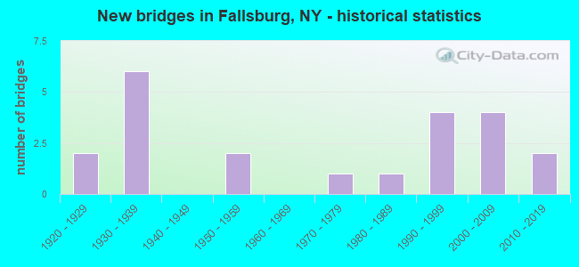
- New bridges - historical statistics
- 21920-1929
- 61930-1939
- 21950-1959
- 11970-1979
- 11980-1989
- 41990-1999
- 42000-2009
- 22010-2019
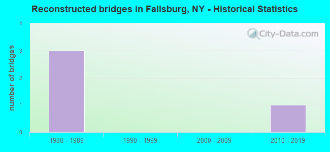
- Reconstructed bridges - Historical Statistics
- 31980-1989
- 01990-1999
- 02000-2009
- 12010-2019
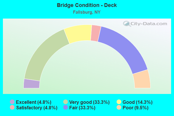
- Bridge Condition - Deck
- 4.8%Excellent
- 33.3%Very good
- 14.3%Good
- 4.8%Satisfactory
- 33.3%Fair
- 9.5%Poor
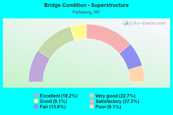
- Bridge Condition - Superstructure
- 18.2%Excellent
- 22.7%Very good
- 9.1%Good
- 27.3%Satisfactory
- 13.6%Fair
- 9.1%Poor
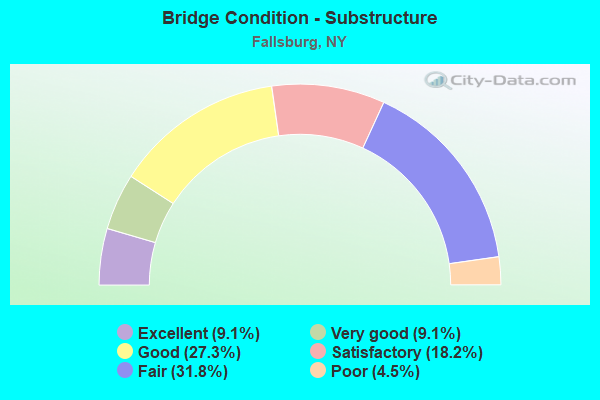
- Bridge Condition - Substructure
- 9.1%Excellent
- 9.1%Very good
- 27.3%Good
- 18.2%Satisfactory
- 31.8%Fair
- 4.5%Poor
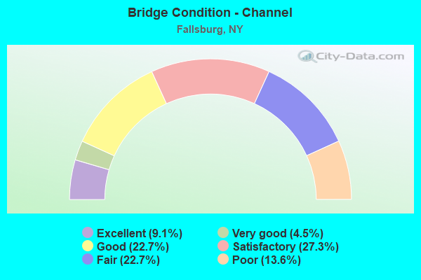
- Bridge Condition - Channel
- 9.1%Excellent
- 4.5%Very good
- 22.7%Good
- 27.3%Satisfactory
- 22.7%Fair
- 13.6%Poor
Find on map >> Show street view
Structure Number: 102499, Location: AT WOODBOURNE (Lat: 41.759933, Lng: -74.599497), Route carried "on" structure: State highway 42, Year Built: 1983, Status: Open, Structure Length: 6.28m (20.60ft), Average Daily Traffic: 9,112 (year 2020), Truck Traffic: 6%, Average Future Daily Traffic: 9,294 (year 2040), Design Load: HS 20, Features Intersected: NEVERSINK RIVER
Minimum Vertical Clearance: 30+ m (98+ ft), Kilometerpoint: 36.138, Lanes on structure: 3, Base Highway Network: Yes, Owner: State Highway Agency, Approaching Roadway Width: 13.4m (44.0ft), Skew: 20 degrees, Material/Design: Prestressed concrete continuous, Design/Construction: Box Beam or Girders - Multiple, Number Of Spans In Main Unit: 2, Length of Maximum Span: 30.4m (99.7ft), Curb or Sidewalk Widths: Left: 1.8m (5.9ft), Right: 1.8m (5.9ft), Curb-To-Curb Width: 13.4m (44.0ft), Out-to-Out Width: 17.8m (58.4ft)
Condition: Deck: Fair, Superstructure: Poor, Substructure: Fair, Channel: Satisfactory, Operating Rating: 45.7 metric tons, Method Used To Determine Operating Rating: Load and Resistance Factor Rating (LRFR) rating reported by rating factor(RF) method using HL-93 loadings, Inventory Rating: 34.0 metric tons, Method Used To Determine Inventory Rating: Load and Resistance Factor Rating (LRFR) rating reported by rating factor(RF) method using HL-93 loadings, Structural Evaluation: Meets minimum limits, Deck Geometry: Somewhat better than minimum adequacy, Waterway Adequacy: Somewhat better than minimum adequacy, Approach Roadway Alignment: Equal to present desirable criteria, Length Of Structure Improvement: 6.27m (20.57ft), Designated Inspection Frequency: Every 24 months, Inspection Date: August 2021, Bridge Improvement Cost: $2,698,000, Roadway Improvement Cost: $1,580,000, Total Project Cost: $4,278,000 ( Estimate for 2021), Wearing Surface/Protective System: Wearing Surface: Integral Concrete
Find on map >> Show street view
Structure Number: 22289, Location: AT SOUTH FALLSBURG (Lat: 41.712647, Lng: -74.632403), Route carried "on" structure: ServiceOther road , Year Built: 1999, Status: Open, Structure Length: 0.82m (2.69ft), Average Daily Traffic: 1,440 (year 2018), Truck Traffic: 7%, Average Future Daily Traffic: 1,781 (year 2040), Design Load: HS 25 or greater, Features Intersected: SHELDRAKE STREAM, Facility Carried by Structure: PLEASANT VLLEY RD
Minimum Vertical Clearance: 30+ m (98+ ft), Kilometerpoint: 0.241, Lanes on structure: 2, Owner: Town or Township Highway Agency, Approaching Roadway Width: 8.5m (27.9ft), Skew: 3 degrees, Material/Design: Concrete, Design/Construction: Frame, Number Of Spans In Main Unit: 1, Length of Maximum Span: 7.6m (24.9ft), Curb-To-Curb Width: 7.3m (24.0ft), Out-to-Out Width: 8.2m (26.9ft)
Condition: Deck: Very good, Superstructure: Good, Substructure: Good, Channel: Very good, Operating Rating: 97.1 metric tons, Method Used To Determine Operating Rating: Load Factor (LF), Inventory Rating: 58.1 metric tons, Method Used To Determine Inventory Rating: Load Factor (LF), Structural Evaluation: Better than present minimum criteria, Deck Geometry: Meets minimum limits, Waterway Adequacy: Equal to present minimum criteria, Approach Roadway Alignment: Meets minimum limits, Length Of Structure Improvement: 0.82m (2.69ft), Designated Inspection Frequency: Every 24 months, Inspection Date: November 2021, Bridge Improvement Cost: $250,000, Roadway Improvement Cost: $146,000, Total Project Cost: $397,000 ( Estimate for 2021), Wearing Surface/Protective System: Wearing Surface: Bituminous, Membrane: Other
Find on map >> Show street view
Structure Number: 222891, Location: .8 MILE SE OF WOODRIDGE (Lat: 41.701064, Lng: -74.549603), Route carried "on" structure: Bypass County highway , Year Built: 1950, Year Reconstructed: 2018, Status: Open, Structure Length: 0.76m (2.49ft), Average Daily Traffic: 119 (year 2019), Truck Traffic: 7%, Average Future Daily Traffic: 167 (year 2039), Features Intersected: SANDBURG CREEK, Facility Carried by Structure: SILVER LAKE ROAD
Minimum Vertical Clearance: 30+ m (98+ ft), Kilometerpoint: 0.161, Lanes on structure: 1, Owner: County Highway Agency, Approaching Roadway Width: 7.6m (24.9ft), Skew: 2 degrees, Material/Design: Prestressed concrete, Design/Construction: Box Beam or Girders - Multiple, Number Of Spans In Main Unit: 1, Length of Maximum Span: 7.0m (23.0ft), Curb-To-Curb Width: 5.8m (19.0ft), Out-to-Out Width: 6.7m (22.0ft)
Condition: Deck: Excellent, Superstructure: Excellent, Substructure: Excellent, Channel: Good, Operating Rating: 92.5 metric tons, Method Used To Determine Operating Rating: Load Factor (LF), Inventory Rating: 55.3 metric tons, Method Used To Determine Inventory Rating: Load Factor (LF), Structural Evaluation: Superior to present desirable criteria, Deck Geometry: High priority of corrective action, Waterway Adequacy: Somewhat better than minimum adequacy, Approach Roadway Alignment: Somewhat better than minimum adequacy, Length Of Structure Improvement: 0.76m (2.49ft), Designated Inspection Frequency: Every 24 months, Inspection Date: November 2020, Bridge Improvement Cost: $149,000, Roadway Improvement Cost: $87,000, Total Project Cost: $236,000 ( Estimate for 2021), Wearing Surface/Protective System: Wearing Surface: Bituminous
Find on map >> Show street view
Structure Number: 222892, Location: 1.2 MI W OF HURLEYVILLE (Lat: 41.743011, Lng: -74.701083), Route carried "on" structure: Other road , Year Built: 2001, Status: Open, Structure Length: 1.22m (4.00ft), Average Daily Traffic: 77 (year 2017), Truck Traffic: 7%, Average Future Daily Traffic: 108 (year 2037), Design Load: HS 25 or greater, Features Intersected: E BR MONGAUP RVR, Facility Carried by Structure: KRUM ROAD
Minimum Vertical Clearance: 30+ m (98+ ft), Kilometerpoint: 0.064, Lanes on structure: 2, Owner: County Highway Agency, Approaching Roadway Width: 6.1m (20.0ft), Material/Design: Prestressed concrete, Design/Construction: Box Beam or Girders - Multiple, Number Of Spans In Main Unit: 1, Length of Maximum Span: 11.0m (36.1ft), Curb-To-Curb Width: 6.8m (22.3ft), Out-to-Out Width: 7.4m (24.3ft)
Condition: Deck: Good, Superstructure: Very good, Substructure: Good, Channel: Satisfactory, Operating Rating: 80.7 metric tons, Method Used To Determine Operating Rating: Load Factor (LF), Inventory Rating: 48.1 metric tons, Method Used To Determine Inventory Rating: Load Factor (LF), Structural Evaluation: Better than present minimum criteria, Deck Geometry: Somewhat better than minimum adequacy, Waterway Adequacy: Somewhat better than minimum adequacy, Approach Roadway Alignment: Equal to present desirable criteria, Length Of Structure Improvement: 1.21m (3.97ft), Designated Inspection Frequency: Every 24 months, Inspection Date: August 2021, Bridge Improvement Cost: $234,000, Roadway Improvement Cost: $137,000, Total Project Cost: $371,000 ( Estimate for 2021), Wearing Surface/Protective System: Wearing Surface: Bituminous, Membrane: Other
Find on map >> Show street view
Structure Number: 222893, Location: 1.5 MI W OF HURLEYVILLE (Lat: 41.742597, Lng: -74.692961), Route carried "on" structure: Other road , Year Built: 1955, Status: Open, Structure Length: 0.76m (2.49ft), Average Daily Traffic: 77 (year 2017), Truck Traffic: 7%, Average Future Daily Traffic: 108 (year 2037), Features Intersected: EAST BRANCH MONGAUP RIVE, Facility Carried by Structure: KRUM ROAD
Minimum Vertical Clearance: 30+ m (98+ ft), Kilometerpoint: 0.821, Lanes on structure: 1, Owner: County Highway Agency, Approaching Roadway Width: 7.9m (25.9ft), Material/Design: Steel, Design/Construction: Stringer/Multi-beam, Number Of Spans In Main Unit: 1, Length of Maximum Span: 7.0m (23.0ft), Curb-To-Curb Width: 4.1m (13.5ft), Out-to-Out Width: 6.7m (22.0ft)
Condition: Deck: Fair, Superstructure: Poor, Substructure: Fair, Channel: Fair, Operating Rating: 88.9 metric tons, Method Used To Determine Operating Rating: Load Factor (LF), Inventory Rating: 52.6 metric tons, Method Used To Determine Inventory Rating: Load Factor (LF), Structural Evaluation: Meets minimum limits, Deck Geometry: Somewhat better than minimum adequacy, Waterway Adequacy: Meets minimum limits, Approach Roadway Alignment: Equal to present desirable criteria, Length Of Structure Improvement: 0.76m (2.49ft), Designated Inspection Frequency: Every 24 months, Inspection Date: June 2021, Bridge Improvement Cost: $199,000, Roadway Improvement Cost: $117,000, Total Project Cost: $316,000 ( Estimate for 2021), Deck Structure Type: Concrete Cast-file-Place, Wearing Surface/Protective System: Wearing Surface: Bituminous
Find on map >> Show street view
Structure Number: 222894, Location: .2 MILE S OF WOODBOURNE (Lat: 41.755617, Lng: -74.595497), Route carried "on" structure: Bypass Other road , Year Built: 1930, Status: Open, Structure Length: 0.82m (2.69ft), Average Daily Traffic: 977 (year 2018), Truck Traffic: 7%, Average Future Daily Traffic: 1,368 (year 2038), Features Intersected: TRB NEVERSINK RVR, Facility Carried by Structure: RIVERSIDE DRIVE
Minimum Vertical Clearance: 30+ m (98+ ft), Kilometerpoint: 2.961, Lanes on structure: 2, Owner: County Highway Agency, Approaching Roadway Width: 8.2m (26.9ft), Skew: 3 degrees, Material/Design: Steel, Design/Construction: Stringer/Multi-beam, Number Of Spans In Main Unit: 1, Length of Maximum Span: 7.9m (25.9ft), Curb-To-Curb Width: 6.2m (20.3ft), Out-to-Out Width: 7.1m (23.3ft)
Condition: Deck: Fair, Superstructure: Fair, Substructure: Fair, Channel: Fair, Operating Rating: 98.0 metric tons, Method Used To Determine Operating Rating: Load Factor (LF), Inventory Rating: 58.1 metric tons, Method Used To Determine Inventory Rating: Load Factor (LF), Structural Evaluation: Somewhat better than minimum adequacy, Deck Geometry: High priority of corrective action, Waterway Adequacy: Somewhat better than minimum adequacy, Approach Roadway Alignment: Equal to present minimum criteria, Length Of Structure Improvement: 0.82m (2.69ft), Designated Inspection Frequency: Every 24 months, Inspection Date: July 2021, Bridge Improvement Cost: $233,000, Roadway Improvement Cost: $137,000, Total Project Cost: $370,000 ( Estimate for 2021), Deck Structure Type: Concrete Cast-file-Place, Wearing Surface/Protective System: Wearing Surface: Bituminous
Find on map >> Show street view
Structure Number: 335553, Location: IN FALLSBURG (Lat: 41.730239, Lng: -74.603919), Route carried "on" structure: County highway , Year Built: 2015, Status: Open, Structure Length: 3.54m (11.61ft), Average Daily Traffic: 3,833 (year 2020), Truck Traffic: 6%, Average Future Daily Traffic: 4,742 (year 2040), Features Intersected: NEVERSINK RIVER, Facility Carried by Structure: COUNTY ROAD 53
Minimum Vertical Clearance: 30+ m (98+ ft), Kilometerpoint: 3.154, Lanes on structure: 2, Owner: County Highway Agency, Approaching Roadway Width: 13.1m (43.0ft), Material/Design: Prestressed concrete, Design/Construction: Stringer/Multi-beam, Number Of Spans In Main Unit: 1, Length of Maximum Span: 34.1m (111.9ft), Curb or Sidewalk Widths: Left: 1.7m (5.6ft), Right: 0.0m, Curb-To-Curb Width: 13.2m (43.3ft), Out-to-Out Width: 15.9m (52.2ft)
Condition: Deck: Satisfactory, Superstructure: Excellent, Substructure: Good, Channel: Excellent, Operating Rating: 55.4 metric tons, Method Used To Determine Operating Rating: Load and Resistance Factor Rating (LRFR) rating reported by rating factor(RF) method using HL-93 loadings, Inventory Rating: 42.1 metric tons, Method Used To Determine Inventory Rating: Load and Resistance Factor Rating (LRFR) rating reported by rating factor(RF) method using HL-93 loadings, Structural Evaluation: Better than present minimum criteria, Deck Geometry: Equal to present minimum criteria, Waterway Adequacy: Equal to present desirable criteria, Approach Roadway Alignment: Equal to present desirable criteria, Length Of Structure Improvement: 3.53m (11.58ft), Designated Inspection Frequency: Every 24 months, Inspection Date: October 2021, Bridge Improvement Cost: $1,456,000, Roadway Improvement Cost: $852,000, Total Project Cost: $2,308,000 ( Estimate for 2021), Deck Structure Type: Concrete Cast-file-Place, Wearing Surface/Protective System: Wearing Surface: Integral Concrete, Deck Protection: Epoxy Coated Reinforcing
Find on map >> Show street view
Structure Number: 335554, Location: 1.5 MI SE OF WOODRIDGE (Lat: 41.697239, Lng: -74.545533), Route carried "on" structure: County highway , Year Built: 1926, Status: Open, Structure Length: 1.01m (3.31ft), Average Daily Traffic: 719 (year 2018), Truck Traffic: 7%, Average Future Daily Traffic: 889 (year 2040), Features Intersected: SANDBURG CREEK, Facility Carried by Structure: MOUNTAINDALE ROAD
Minimum Vertical Clearance: 30+ m (98+ ft), Kilometerpoint: 1.963, Lanes on structure: 2, Owner: County Highway Agency, Approaching Roadway Width: 9.8m (32.2ft), Material/Design: Steel, Design/Construction: Stringer/Multi-beam, Number Of Spans In Main Unit: 1, Length of Maximum Span: 9.4m (30.8ft), Curb-To-Curb Width: 9.8m (32.2ft), Out-to-Out Width: 10.2m (33.5ft)
Condition: Deck: Poor, Superstructure: Satisfactory, Substructure: Fair, Channel: Fair, Inventory Rating: 64.4 metric tons, Method Used To Determine Inventory Rating: Load Factor (LF), Structural Evaluation: Somewhat better than minimum adequacy, Deck Geometry: Equal to present minimum criteria, Waterway Adequacy: Meets minimum limits, Approach Roadway Alignment: Equal to present desirable criteria, Length Of Structure Improvement: 1.00m (3.28ft), Designated Inspection Frequency: Every 24 months, Inspection Date: May 2021, Bridge Improvement Cost: $352,000, Roadway Improvement Cost: $206,000, Total Project Cost: $558,000 ( Estimate for 2021), Deck Structure Type: Concrete Cast-file-Place, Wearing Surface/Protective System: Wearing Surface: Bituminous
Find on map >> Show street view
Structure Number: 335555, Location: 1.9 MILES SE OF WOODRIDGE (Lat: 41.694969, Lng: -74.540908), Route carried "on" structure: County highway , Year Built: 1938, Status: Open, Structure Length: 0.88m (2.89ft), Average Daily Traffic: 719 (year 2018), Truck Traffic: 7%, Average Future Daily Traffic: 889 (year 2040), Features Intersected: SANDBURG CREEK, Facility Carried by Structure: COUNTY ROAD 54
Minimum Vertical Clearance: 30+ m (98+ ft), Kilometerpoint: 2.430, Lanes on structure: 2, Owner: County Highway Agency, Approaching Roadway Width: 9.1m (29.9ft), Skew: 3 degrees, Material/Design: Steel, Design/Construction: Stringer/Multi-beam, Number Of Spans In Main Unit: 1, Length of Maximum Span: 8.2m (26.9ft), Curb-To-Curb Width: 8.1m (26.6ft), Out-to-Out Width: 9.1m (29.9ft)
Condition: Deck: Fair, Superstructure: Satisfactory, Substructure: Poor, Channel: Poor, Inventory Rating: 78.0 metric tons, Method Used To Determine Inventory Rating: Load Factor (LF), Structural Evaluation: Meets minimum limits, Deck Geometry: Somewhat better than minimum adequacy, Waterway Adequacy: Meets minimum limits, Approach Roadway Alignment: Equal to present desirable criteria, Length Of Structure Improvement: 0.88m (2.89ft), Designated Inspection Frequency: Every 24 months, Inspection Date: August 2021, Bridge Improvement Cost: $338,000, Roadway Improvement Cost: $198,000, Total Project Cost: $536,000 ( Estimate for 2021), Deck Structure Type: Concrete Cast-file-Place, Wearing Surface/Protective System: Wearing Surface: Bituminous
Find on map >> Show street view
Structure Number: 335556, Location: CTR OF MOUNTAINDALE (Lat: 41.691997, Lng: -74.534486), Route carried "on" structure: County highway , Year Built: 1996, Status: Open, Structure Length: 0.67m (2.20ft), Average Daily Traffic: 820 (year 2016), Truck Traffic: 6%, Average Future Daily Traffic: 1,014 (year 2040), Design Load: HS 20, Features Intersected: SANDBURG CREEK, Facility Carried by Structure: MOUNTAINDALE ROAD
Minimum Vertical Clearance: 30+ m (98+ ft), Kilometerpoint: 0.225, Lanes on structure: 2, Owner: County Highway Agency, Approaching Roadway Width: 6.1m (20.0ft), Skew: 1 degrees, Material/Design: Concrete, Design/Construction: Frame, Number Of Spans In Main Unit: 1, Length of Maximum Span: 6.4m (21.0ft), Curb-To-Curb Width: 8.7m (28.5ft), Out-to-Out Width: 9.8m (32.2ft)
Condition: Deck: Very good, Superstructure: Very good, Substructure: Very good, Channel: Good, Operating Rating: 77.1 metric tons, Method Used To Determine Operating Rating: Field evaluation and documented engineering judgment, Inventory Rating: 32.7 metric tons, Method Used To Determine Inventory Rating: Field evaluation and documented engineering judgment, Structural Evaluation: Equal to present desirable criteria, Deck Geometry: Somewhat better than minimum adequacy, Waterway Adequacy: Meets minimum limits, Approach Roadway Alignment: Equal to present desirable criteria, Length Of Structure Improvement: 0.67m (2.20ft), Designated Inspection Frequency: Every 24 months, Inspection Date: July 2020, Bridge Improvement Cost: $270,000, Roadway Improvement Cost: $158,000, Total Project Cost: $428,000 ( Estimate for 2021), Wearing Surface/Protective System: Wearing Surface: Bituminous
Find on map >> Show street view
Structure Number: 335557, Location: .4 MI SE OF MOUNTAINDALE (Lat: 41.686756, Lng: -74.523642), Route carried "on" structure: County highway , Year Built: 1932, Status: Open, Structure Length: 0.98m (3.22ft), Average Daily Traffic: 820 (year 2016), Truck Traffic: 6%, Average Future Daily Traffic: 855 (year 2040), Features Intersected: SANDBURG CREEK, Facility Carried by Structure: COUNTY ROAD 55
Minimum Vertical Clearance: 30+ m (98+ ft), Kilometerpoint: 1.319, Lanes on structure: 2, Owner: County Highway Agency, Approaching Roadway Width: 9.1m (29.9ft), Skew: 2 degrees, Material/Design: Steel, Design/Construction: Stringer/Multi-beam, Number Of Spans In Main Unit: 1, Length of Maximum Span: 8.8m (28.9ft), Curb-To-Curb Width: 8.0m (26.2ft), Out-to-Out Width: 8.4m (27.6ft)
Condition: Deck: Fair, Superstructure: Fair, Substructure: Fair, Channel: Satisfactory, Operating Rating: 74.4 metric tons, Method Used To Determine Operating Rating: Load Factor (LF), Inventory Rating: 44.5 metric tons, Method Used To Determine Inventory Rating: Load Factor (LF), Structural Evaluation: Somewhat better than minimum adequacy, Deck Geometry: Somewhat better than minimum adequacy, Waterway Adequacy: Somewhat better than minimum adequacy, Approach Roadway Alignment: Somewhat better than minimum adequacy, Length Of Structure Improvement: 0.97m (3.18ft), Designated Inspection Frequency: Every 24 months, Inspection Date: August 2021, Bridge Improvement Cost: $410,000, Roadway Improvement Cost: $240,000, Total Project Cost: $650,000 ( Estimate for 2021), Deck Structure Type: Concrete Cast-file-Place, Wearing Surface/Protective System: Wearing Surface: Bituminous
Find on map >> Show street view
Structure Number: 335558, Location: 0.7 MI SE OF MOUNTAINDALE (Lat: 41.684089, Lng: -74.524425), Route carried "on" structure: County highway , Year Built: 1932, Status: Open, Structure Length: 1.16m (3.81ft), Average Daily Traffic: 820 (year 2016), Truck Traffic: 6%, Average Future Daily Traffic: 855 (year 2040), Features Intersected: SANDBURG CREEK, Facility Carried by Structure: MOUNTAINDALE ROAD
Minimum Vertical Clearance: 30+ m (98+ ft), Kilometerpoint: 1.641, Lanes on structure: 2, Owner: County Highway Agency, Approaching Roadway Width: 9.4m (30.8ft), Skew: 1 degrees, Material/Design: Steel, Design/Construction: Stringer/Multi-beam, Number Of Spans In Main Unit: 1, Length of Maximum Span: 11.2m (36.7ft), Curb-To-Curb Width: 8.7m (28.5ft), Out-to-Out Width: 9.7m (31.8ft)
Condition: Deck: Fair, Superstructure: Satisfactory, Substructure: Fair, Channel: Fair, Operating Rating: 99.8 metric tons, Method Used To Determine Operating Rating: Load Factor (LF), Inventory Rating: 59.9 metric tons, Method Used To Determine Inventory Rating: Load Factor (LF), Structural Evaluation: Somewhat better than minimum adequacy, Deck Geometry: Somewhat better than minimum adequacy, Waterway Adequacy: Meets minimum limits, Approach Roadway Alignment: Somewhat better than minimum adequacy, Length Of Structure Improvement: 1.15m (3.77ft), Designated Inspection Frequency: Every 24 months, Inspection Date: April 2021, Bridge Improvement Cost: $393,000, Roadway Improvement Cost: $230,000, Total Project Cost: $623,000 ( Estimate for 2021), Deck Structure Type: Concrete Cast-file-Place, Wearing Surface/Protective System: Wearing Surface: Bituminous
Find on map >> Show street view
Structure Number: 335559, Location: .8 MI SE OF MOUNTAINDALE (Lat: 41.683336, Lng: -74.524361), Route carried "on" structure: County highway , Year Built: 2004, Status: Open, Structure Length: 1.10m (3.61ft), Average Daily Traffic: 190 (year 2020), Truck Traffic: 8%, Average Future Daily Traffic: 198 (year 2040), Design Load: HS 25 or greater, Features Intersected: SANDBURG CREEK, Facility Carried by Structure: MOUNTAINDALE ROAD
Minimum Vertical Clearance: 30+ m (98+ ft), Kilometerpoint: 1.738, Lanes on structure: 2, Owner: County Highway Agency, Approaching Roadway Width: 9.8m (32.2ft), Skew: 3 degrees, Material/Design: Prestressed concrete, Design/Construction: Box Beam or Girders - Multiple, Number Of Spans In Main Unit: 1, Length of Maximum Span: 10.4m (34.1ft), Curb-To-Curb Width: 9.2m (30.2ft), Out-to-Out Width: 9.8m (32.2ft)
Condition: Deck: Very good, Superstructure: Very good, Substructure: Satisfactory, Channel: Satisfactory, Operating Rating: 80.7 metric tons, Method Used To Determine Operating Rating: Load Factor (LF), Inventory Rating: 48.1 metric tons, Method Used To Determine Inventory Rating: Load Factor (LF), Structural Evaluation: Equal to present minimum criteria, Deck Geometry: Equal to present minimum criteria, Waterway Adequacy: Somewhat better than minimum adequacy, Approach Roadway Alignment: Somewhat better than minimum adequacy, Length Of Structure Improvement: 1.09m (3.58ft), Designated Inspection Frequency: Every 24 months, Inspection Date: August 2020, Bridge Improvement Cost: $501,000, Roadway Improvement Cost: $293,000, Total Project Cost: $795,000 ( Estimate for 2021), Wearing Surface/Protective System: Wearing Surface: Bituminous
Find on map >> Show street view
Structure Number: 33556, Location: 1 MILE SE OF MOUNTAINDALE (Lat: 41.680014, Lng: -74.520233), Route carried "on" structure: County highway , Year Built: 2006, Status: Open, Structure Length: 1.10m (3.61ft), Average Daily Traffic: 190 (year 2020), Truck Traffic: 8%, Average Future Daily Traffic: 198 (year 2040), Features Intersected: SANDBURG CREEK, Facility Carried by Structure: COUNTY ROAD 55
Minimum Vertical Clearance: 30+ m (98+ ft), Kilometerpoint: 2.253, Lanes on structure: 2, Owner: County Highway Agency, Approaching Roadway Width: 9.1m (29.9ft), Skew: 1 degrees, Material/Design: Prestressed concrete, Design/Construction: Box Beam or Girders - Multiple, Number Of Spans In Main Unit: 1, Length of Maximum Span: 9.8m (32.2ft), Curb-To-Curb Width: 9.2m (30.2ft), Out-to-Out Width: 9.8m (32.2ft)
Condition: Deck: Very good, Superstructure: Very good, Substructure: Good, Channel: Good, Operating Rating: 65.3 metric tons, Method Used To Determine Operating Rating: Load Factor (LF), Inventory Rating: 39.0 metric tons, Method Used To Determine Inventory Rating: Load Factor (LF), Structural Evaluation: Better than present minimum criteria, Deck Geometry: Equal to present minimum criteria, Waterway Adequacy: Somewhat better than minimum adequacy, Approach Roadway Alignment: Equal to present desirable criteria, Length Of Structure Improvement: 1.09m (3.58ft), Designated Inspection Frequency: Every 24 months, Inspection Date: August 2020, Bridge Improvement Cost: $451,000, Roadway Improvement Cost: $264,000, Total Project Cost: $715,000 ( Estimate for 2021), Wearing Surface/Protective System: Wearing Surface: Bituminous, Membrane: Other
Find on map >> Show street view
Structure Number: 335561, Location: 1.4 MI SE OF MOUNTAINDALE (Lat: 41.676658, Lng: -74.514967), Route carried "on" structure: County highway , Year Built: 1932, Year Reconstructed: 1987, Status: Open, Structure Length: 1.25m (4.10ft), Average Daily Traffic: 190 (year 2020), Truck Traffic: 8%, Average Future Daily Traffic: 198 (year 2040), Features Intersected: SANDBURG CREEK, Facility Carried by Structure: COUNTY ROAD 55
Minimum Vertical Clearance: 30+ m (98+ ft), Kilometerpoint: 2.848, Lanes on structure: 2, Owner: County Highway Agency, Approaching Roadway Width: 7.0m (23.0ft), Skew: 3 degrees, Material/Design: Steel, Design/Construction: Stringer/Multi-beam, Number Of Spans In Main Unit: 1, Length of Maximum Span: 11.3m (37.1ft), Curb-To-Curb Width: 6.8m (22.3ft), Out-to-Out Width: 7.8m (25.6ft)
Condition: Deck: Poor, Superstructure: Satisfactory, Substructure: Fair, Channel: Poor, Operating Rating: 90.7 metric tons, Method Used To Determine Operating Rating: Load Factor (LF), Inventory Rating: 54.4 metric tons, Method Used To Determine Inventory Rating: Load Factor (LF), Structural Evaluation: Somewhat better than minimum adequacy, Deck Geometry: Meets minimum limits, Waterway Adequacy: Meets minimum limits, Approach Roadway Alignment: Somewhat better than minimum adequacy, Length Of Structure Improvement: 1.24m (4.07ft), Designated Inspection Frequency: Every 24 months, Inspection Date: July 2021, Bridge Improvement Cost: $310,000, Roadway Improvement Cost: $181,000, Total Project Cost: $491,000 ( Estimate for 2021), Deck Structure Type: Concrete Cast-file-Place, Wearing Surface/Protective System: Wearing Surface: Bituminous
Find on map >> Show street view
Structure Number: 335584, Location: 0.2 MI S OF HURLEYVILLE (Lat: 41.731589, Lng: -74.676161), Route carried "on" structure: County highway , Year Built: 1994, Status: Open, Structure Length: 1.28m (4.20ft), Average Daily Traffic: 2,997 (year 2018), Truck Traffic: 3%, Average Future Daily Traffic: 3,026 (year 2040), Design Load: HS 20+Mod, Features Intersected: TRIBUTARY EAST MONGAUP R, Facility Carried by Structure: LOCH SHELDRAKE ROA
Minimum Vertical Clearance: 30+ m (98+ ft), Kilometerpoint: 1.834, Lanes on structure: 2, Owner: County Highway Agency, Approaching Roadway Width: 7.3m (24.0ft), Skew: 1 degrees, Material/Design: Prestressed concrete, Design/Construction: Box Beam or Girders - Multiple, Number Of Spans In Main Unit: 1, Length of Maximum Span: 11.5m (37.7ft), Curb-To-Curb Width: 10.7m (35.1ft), Out-to-Out Width: 11.3m (37.1ft)
Condition: Deck: Very good, Superstructure: Good, Substructure: Good, Channel: Good, Operating Rating: 83.5 metric tons, Method Used To Determine Operating Rating: Load Factor (LF), Inventory Rating: 49.9 metric tons, Method Used To Determine Inventory Rating: Load Factor (LF), Structural Evaluation: Better than present minimum criteria, Deck Geometry: Somewhat better than minimum adequacy, Waterway Adequacy: Equal to present minimum criteria, Approach Roadway Alignment: Equal to present desirable criteria, Length Of Structure Improvement: 1.28m (4.20ft), Designated Inspection Frequency: Every 24 months, Inspection Date: June 2020, Bridge Improvement Cost: $493,000, Roadway Improvement Cost: $289,000, Total Project Cost: $781,000 ( Estimate for 2021), Wearing Surface/Protective System: Wearing Surface: Bituminous, Membrane: Other
Find on map >> Show street view
Structure Number: 335585, Location: 0.7 MI N OF HURLEYVILLE (Lat: 41.747631, Lng: -74.668958), Route carried "on" structure: County highway , Year Built: 1976, Status: Open, Structure Length: 1.46m (4.79ft), Average Daily Traffic: 2,997 (year 2018), Truck Traffic: 3%, Average Future Daily Traffic: 3,026 (year 2040), Design Load: H 20, Features Intersected: TB E B MONGAUP RV, Facility Carried by Structure: LOCH SHELDRAKE RD
Minimum Vertical Clearance: 30+ m (98+ ft), Kilometerpoint: 3.829, Lanes on structure: 2, Owner: County Highway Agency, Approaching Roadway Width: 11.6m (38.1ft), Material/Design: Steel, Design/Construction: Stringer/Multi-beam, Number Of Spans In Main Unit: 1, Length of Maximum Span: 13.4m (44.0ft), Curb or Sidewalk Widths: Left: 1.5m (4.9ft), Right: 1.5m (4.9ft), Curb-To-Curb Width: 8.5m (27.9ft), Out-to-Out Width: 12.0m (39.4ft)
Condition: Deck: Very good, Superstructure: Very good, Substructure: Good, Channel: Satisfactory, Operating Rating: 90.7 metric tons, Method Used To Determine Operating Rating: Load Factor (LF), Inventory Rating: 54.4 metric tons, Method Used To Determine Inventory Rating: Load Factor (LF), Structural Evaluation: Better than present minimum criteria, Deck Geometry: Meets minimum limits, Waterway Adequacy: Somewhat better than minimum adequacy, Approach Roadway Alignment: High priority of corrective action, Length Of Structure Improvement: 1.46m (4.79ft), Designated Inspection Frequency: Every 24 months, Inspection Date: July 2021, Bridge Improvement Cost: $494,000, Roadway Improvement Cost: $289,000, Total Project Cost: $783,000 ( Estimate for 2021), Deck Structure Type: Concrete Cast-file-Place, Wearing Surface/Protective System: Wearing Surface: Bituminous
Find on map >> Show street view
Structure Number: 335652, Location: AT MOUNTAIN DALE (Lat: 41.688456, Lng: -74.530556), Route carried "on" structure: Other road , Year Built: 1929, Year Reconstructed: 1994, Status: Open, Structure Length: 1.34m (4.40ft), Average Daily Traffic: 355 (year 2019), Truck Traffic: 5%, Average Future Daily Traffic: 497 (year 2039), Features Intersected: SANDBURG CREEK, Facility Carried by Structure: CHURCH ROAD
Minimum Vertical Clearance: 30+ m (98+ ft), Kilometerpoint: 5.985, Lanes on structure: 2, Owner: County Highway Agency, Approaching Roadway Width: 5.5m (18.0ft), Material/Design: Steel, Design/Construction: Stringer/Multi-beam, Number Of Spans In Main Unit: 1, Length of Maximum Span: 12.8m (42.0ft), Curb-To-Curb Width: 6.3m (20.7ft), Out-to-Out Width: 7.4m (24.3ft)
Condition: Deck: Good, Superstructure: Satisfactory, Substructure: Satisfactory, Channel: Fair, Operating Rating: 56.2 metric tons, Method Used To Determine Operating Rating: Load Factor (LF), Inventory Rating: 33.6 metric tons, Method Used To Determine Inventory Rating: Load Factor (LF), Structural Evaluation: Equal to present minimum criteria, Deck Geometry: Meets minimum limits, Waterway Adequacy: Meets minimum limits, Approach Roadway Alignment: Equal to present desirable criteria, Length Of Structure Improvement: 1.34m (4.40ft), Designated Inspection Frequency: Every 24 months, Inspection Date: July 2020, Bridge Improvement Cost: $410,000, Roadway Improvement Cost: $240,000, Total Project Cost: $650,000 ( Estimate for 2021), Deck Structure Type: Concrete Cast-file-Place, Wearing Surface/Protective System: Wearing Surface: Bituminous
Find on map >> Show street view
Structure Number: 335654, Location: 2.7 MI SOUTH OF NEVERSINK (Lat: 41.788036, Lng: -74.615550), Route carried "on" structure: Other road , Year Built: 1991, Status: Open, Structure Length: 5.61m (18.41ft), Average Daily Traffic: 971 (year 2016), Truck Traffic: 5%, Average Future Daily Traffic: 1,359 (year 2036), Design Load: H 20, Features Intersected: NEVERSINK RIVER, Facility Carried by Structure: HASBROUCK A ROAD
Minimum Vertical Clearance: 30+ m (98+ ft), Kilometerpoint: 4.216, Lanes on structure: 2, Owner: County Highway Agency, Approaching Roadway Width: 7.9m (25.9ft), Skew: 1 degrees, Material/Design: Steel, Design/Construction: Stringer/Multi-beam, Number Of Spans In Main Unit: 2, Length of Maximum Span: 27.7m (90.9ft), Curb-To-Curb Width: 7.3m (24.0ft), Out-to-Out Width: 7.9m (25.9ft)
Condition: Deck: Good, Superstructure: Satisfactory, Substructure: Satisfactory, Channel: Satisfactory, Operating Rating: 63.5 metric tons, Method Used To Determine Operating Rating: Load Factor (LF), Inventory Rating: 32.7 metric tons, Method Used To Determine Inventory Rating: Load Factor (LF), Structural Evaluation: Equal to present minimum criteria, Deck Geometry: Meets minimum limits, Waterway Adequacy: Somewhat better than minimum adequacy, Approach Roadway Alignment: Equal to present minimum criteria, Length Of Structure Improvement: 5.60m (18.37ft), Designated Inspection Frequency: Every 24 months, Inspection Date: June 2021, Bridge Improvement Cost: $1,126,000, Roadway Improvement Cost: $660,000, Total Project Cost: $1,786,000 ( Estimate for 2021), Deck Structure Type: Concrete Cast-file-Place, Wearing Surface/Protective System: Wearing Surface: Integral Concrete, Deck Protection: Epoxy Coated Reinforcing
Find on map >> Show street view
Structure Number: 335655, Location: 2.3 MI NW OF WOODBOURNE (Lat: 41.791889, Lng: -74.616142), Route carried "on" structure: Alternate Other road , Year Built: 1938, Year Reconstructed: 1993, Status: Open, Structure Length: 1.25m (4.10ft), Average Daily Traffic: 982 (year 2019), Truck Traffic: 6%, Average Future Daily Traffic: 1,375 (year 2039), Features Intersected: WYNKOOP BROOK, Facility Carried by Structure: HASBROUCK ROAD
Minimum Vertical Clearance: 30+ m (98+ ft), Kilometerpoint: 2.156, Lanes on structure: 2, Owner: County Highway Agency, Approaching Roadway Width: 5.5m (18.0ft), Skew: 3 degrees, Material/Design: Steel, Design/Construction: Stringer/Multi-beam, Number Of Spans In Main Unit: 1, Length of Maximum Span: 11.5m (37.7ft), Curb-To-Curb Width: 7.2m (23.6ft), Out-to-Out Width: 7.7m (25.3ft)
Condition: Deck: Fair, Superstructure: Fair, Substructure: Satisfactory, Channel: Poor, Inventory Rating: 60.8 metric tons, Method Used To Determine Inventory Rating: Load Factor (LF), Structural Evaluation: Somewhat better than minimum adequacy, Deck Geometry: Meets minimum limits, Waterway Adequacy: Meets minimum limits, Approach Roadway Alignment: Better than present minimum criteria, Length Of Structure Improvement: 1.24m (4.07ft), Designated Inspection Frequency: Every 24 months, Inspection Date: August 2021, Bridge Improvement Cost: $404,000, Roadway Improvement Cost: $236,000, Total Project Cost: $640,000 ( Estimate for 2021), Deck Structure Type: Concrete Cast-file-Place, Wearing Surface/Protective System: Wearing Surface: Bituminous
Find on map >> Show street view
Structure Number: 337013, Location: JCT CR 105 & DWYER AVENUE (Lat: 41.807722, Lng: -74.638169), Route carried "on" structure: County highway , Year Built: 2004, Status: Open, Structure Length: 0.76m (2.49ft), Average Daily Traffic: 1,421 (year 2020), Truck Traffic: 4%, Average Future Daily Traffic: 1,989 (year 2040), Design Load: HS 25 or greater, Features Intersected: TRIB NEVERSINK RIVER, Facility Carried by Structure: COUNTY ROAD 105
Minimum Vertical Clearance: 30+ m (98+ ft), Kilometerpoint: 4.763, Lanes on structure: 2, Owner: County Highway Agency, Approaching Roadway Width: 6.7m (22.0ft), Skew: 3 degrees, Material/Design: Concrete, Design/Construction: Frame, Number Of Spans In Main Unit: 1, Length of Maximum Span: 6.7m (22.0ft), Curb-To-Curb Width: 9.2m (30.2ft), Out-to-Out Width: 10.1m (33.1ft)
Condition: Superstructure: Excellent, Substructure: Excellent, Channel: Good, Inventory Rating: 60.8 metric tons, Method Used To Determine Inventory Rating: Load Factor (LF), Structural Evaluation: Superior to present desirable criteria, Deck Geometry: Somewhat better than minimum adequacy, Waterway Adequacy: Somewhat better than minimum adequacy, Approach Roadway Alignment: Equal to present desirable criteria, Length Of Structure Improvement: 0.76m (2.49ft), Designated Inspection Frequency: Every 24 months, Inspection Date: September 2020, Bridge Improvement Cost: $323,000, Roadway Improvement Cost: $189,000, Total Project Cost: $512,000 ( Estimate for 2021)
Find on map >> Show street view
Structure Number: 337063, Location: 1.8 MI NW OF GLEN WILD (Lat: 41.677694, Lng: -74.597992), Route carried "on" structure: Alternate Other road , Year Built: 2010, Status: Open, Structure Length: 6.28m (20.60ft), Average Daily Traffic: 725 (year 2016), Truck Traffic: 3%, Average Future Daily Traffic: 1,015 (year 2036), Features Intersected: NEVERSINK RIVER, Facility Carried by Structure: GREY ROAD
Minimum Vertical Clearance: 30+ m (98+ ft), Kilometerpoint: 0.016, Lanes on structure: 2, Owner: County Highway Agency, Approaching Roadway Width: 7.9m (25.9ft), Material/Design: Steel, Design/Construction: Stringer/Multi-beam, Number Of Spans In Main Unit: 1, Length of Maximum Span: 62.5m (205.1ft), Curb-To-Curb Width: 8.0m (26.2ft), Out-to-Out Width: 9.1m (29.9ft)
Condition: Deck: Very good, Superstructure: Excellent, Substructure: Very good, Channel: Excellent, Operating Rating: 70.0 metric tons, Method Used To Determine Operating Rating: Load Factor (LF), Inventory Rating: 42.0 metric tons, Method Used To Determine Inventory Rating: Load Factor (LF), Structural Evaluation: Equal to present desirable criteria, Deck Geometry: Somewhat better than minimum adequacy, Waterway Adequacy: Equal to present desirable criteria, Approach Roadway Alignment: Equal to present desirable criteria, Length Of Structure Improvement: 6.27m (20.57ft), Designated Inspection Frequency: Every 24 months, Inspection Date: August 2020, Bridge Improvement Cost: $1,299,000, Roadway Improvement Cost: $761,000, Total Project Cost: $2,059,000 ( Estimate for 2021), Deck Structure Type: Concrete Cast-file-Place, Wearing Surface/Protective System: Wearing Surface: Monolithic Concrete, Deck Protection: Epoxy Coated Reinforcing