Bridge Statistics for Fancy Gap, Virginia (VA)
Condition, Traffic, Stress, Structural Evaluation, Project Costs
- National Bridge Inventory (NBI) Statistics
- 29Number of bridges
- 226ft / 69.0mTotal length
- $6,332,000Total costs
- 170,781Total average daily traffic
- 33,917Total average daily truck traffic
- National Bridge Inventory (NBI) Registered Bridges for Fancy Gap
- No street view available for this location
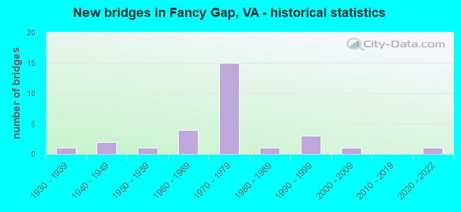
- New bridges - historical statistics
- 11930-1939
- 21940-1949
- 11950-1959
- 41960-1969
- 151970-1979
- 11980-1989
- 31990-1999
- 12000-2009
- 12020-2022


- Bridge Condition - Deck
- 6.7%Excellent
- 13.3%Very good
- 33.3%Good
- 33.3%Satisfactory
- 13.3%Fair

- Bridge Condition - Superstructure
- 6.3%Excellent
- 25.0%Very good
- 6.3%Good
- 43.8%Satisfactory
- 18.8%Fair

- Bridge Condition - Substructure
- 6.3%Very good
- 43.8%Good
- 50.0%Satisfactory

- Bridge Condition - Channel
- 20.0%Very good
- 20.0%Good
- 60.0%Satisfactory

- Bridge Condition - Culverts
- 50.0%Good
- 37.5%Satisfactory
- 12.5%Fair
Find on map >> Show street view
Structure Number: 4537, Location: 1.10-Rte608; 2.47-Rte688 (Lat: 36.650106, Lng: -80.694967), Route carried "on" structure: Alternate US 52, Year Built: 1932, Status: Open, Structure Length: 0.70m (2.30ft), Average Daily Traffic: 3,706 (year 2020), Truck Traffic: 3%, Average Future Daily Traffic: 4,077 (year 2040), Features Intersected: Little Pauls Creek
Minimum Vertical Clearance: 30+ m (98+ ft), Kilometerpoint: 11.836, Lanes on structure: 3, Base Highway Network: Yes, Owner: State Highway Agency, Approaching Roadway Width: 11.3m (37.1ft), Skew: 4 degrees, Material/Design: Concrete, Design/Construction: Slab, Number Of Spans In Main Unit: 1, Length of Maximum Span: 7.0m (23.0ft), Curb-To-Curb Width: 13.1m (43.0ft), Out-to-Out Width: 14.0m (45.9ft)
Condition: Deck: Satisfactory, Superstructure: Satisfactory, Substructure: Satisfactory, Channel: Satisfactory, Operating Rating: 32.7 metric tons, Method Used To Determine Operating Rating: Field evaluation and documented engineering judgment, Inventory Rating: 32.7 metric tons, Method Used To Determine Inventory Rating: Field evaluation and documented engineering judgment, Structural Evaluation: Equal to present minimum criteria, Deck Geometry: Meets minimum limits, Waterway Adequacy: Somewhat better than minimum adequacy, Approach Roadway Alignment: Equal to present desirable criteria, Length Of Structure Improvement: 0.91m (2.99ft), Designated Inspection Frequency: Every 24 months, Inspection Date: March 2021, Bridge Improvement Cost: $409,000, Roadway Improvement Cost: $143,000, Total Project Cost: $1,329,000 ( Estimate for 2015), Deck Structure Type: Concrete Cast-file-Place, Wearing Surface/Protective System: Wearing Surface: Bituminous
Find on map >> Show street view
Structure Number: 4565, Location: 8.78-NC LINE; 6.24-RT 58 (Lat: 36.673731, Lng: -80.709697), Route carried "on" structure: Interstate 77, Year Built: 1976, Status: Open, Structure Length: 5.46m (17.91ft), Average Daily Traffic: 15,979 (year 2020), Truck Traffic: 31%, Average Future Daily Traffic: 22,371 (year 2040), Design Load: HS 20+Mod, Features Intersected: RTE 148_CHANCES CREEK RD
Minimum Vertical Clearance: 30+ m (98+ ft), Kilometerpoint: 14.111, Lanes on structure: 2, Lanes under structure: 4, Base Highway Network: Yes, Owner: State Highway Agency, Approaching Roadway Width: 7.3m (24.0ft), Skew: 1 degrees, Material/Design: Concrete, Design/Construction: Tee Beam, Number Of Spans In Main Unit: 4, Length of Maximum Span: 13.4m (44.0ft), Curb-To-Curb Width: 12.2m (40.0ft), Out-to-Out Width: 13.4m (44.0ft)
Condition: Deck: Fair, Superstructure: Satisfactory, Substructure: Satisfactory, Operating Rating: 60.8 metric tons, Method Used To Determine Operating Rating: Load and Resistance Factor (LRFR), Inventory Rating: 46.3 metric tons, Method Used To Determine Inventory Rating: Load and Resistance Factor (LRFR), Structural Evaluation: Equal to present minimum criteria, Deck Geometry: Better than present minimum criteria, Underclear: Meets minimum limits, Approach Roadway Alignment: Equal to present desirable criteria, Designated Inspection Frequency: Every 24 months, Inspection Date: July 2021, Deck Structure Type: Concrete Cast-file-Place
Find on map >> Show street view
Structure Number: 4567, Location: 8.78-NC LINE; 6.24-RT 58 (Lat: 36.673892, Lng: -80.709383), Route carried "on" structure: Interstate 77, Year Built: 1976, Status: Open, Structure Length: 5.46m (17.91ft), Average Daily Traffic: 16,918 (year 2020), Truck Traffic: 28%, Average Future Daily Traffic: 23,685 (year 2040), Design Load: HS 20+Mod, Features Intersected: RTE 148/CHANCES CREEK RD
Minimum Vertical Clearance: 30+ m (98+ ft), Kilometerpoint: 14.111, Lanes on structure: 2, Lanes under structure: 4, Base Highway Network: Yes, Owner: State Highway Agency, Approaching Roadway Width: 7.3m (24.0ft), Skew: 1 degrees, Material/Design: Concrete, Design/Construction: Tee Beam, Number Of Spans In Main Unit: 4, Length of Maximum Span: 13.4m (44.0ft), Curb-To-Curb Width: 12.2m (40.0ft), Out-to-Out Width: 13.4m (44.0ft)
Condition: Deck: Fair, Superstructure: Satisfactory, Substructure: Satisfactory, Operating Rating: 60.8 metric tons, Method Used To Determine Operating Rating: Load and Resistance Factor (LRFR), Inventory Rating: 46.3 metric tons, Method Used To Determine Inventory Rating: Load and Resistance Factor (LRFR), Structural Evaluation: Equal to present minimum criteria, Deck Geometry: Better than present minimum criteria, Underclear: Meets minimum limits, Approach Roadway Alignment: Equal to present desirable criteria, Designated Inspection Frequency: Every 24 months, Inspection Date: July 2021, Deck Structure Type: Concrete Cast-file-Place
Find on map >> Show street view
Structure Number: 4591, Location: 0.08-Rte148; 6.15-Rte58 (Lat: 36.675108, Lng: -80.709914), Route carried "on" structure: Interstate 77, Year Built: 1977, Status: Open, Structure Length: 1.10m (3.61ft), Average Daily Traffic: 33,464 (year 2020), Truck Traffic: 28%, Average Future Daily Traffic: 46,850 (year 2040), Design Load: HS 20+Mod, Features Intersected: E Frk Little Reed Isl Cr
Minimum Vertical Clearance: 30+ m (98+ ft), Kilometerpoint: 14.256, Lanes on structure: 4, Base Highway Network: Yes, Owner: State Highway Agency, Approaching Roadway Width: 14.3m (46.9ft), Skew: 3 degrees, Material/Design: Concrete, Design/Construction: Culvert, Number Of Spans In Main Unit: 3, Length of Maximum Span: 3.0m (9.8ft)
Condition: Channel: Satisfactory, Culverts: Fair, Operating Rating: 89.8 metric tons, Method Used To Determine Operating Rating: Load Factor (LF), Inventory Rating: 88.9 metric tons, Method Used To Determine Inventory Rating: Load Factor (LF), Structural Evaluation: Somewhat better than minimum adequacy, Waterway Adequacy: Equal to present desirable criteria, Approach Roadway Alignment: Equal to present desirable criteria, Length Of Structure Improvement: 1.10m (3.61ft), Designated Inspection Frequency: Every 24 months, Inspection Date: August 2020, Bridge Improvement Cost: $585,000, Roadway Improvement Cost: $205,000, Total Project Cost: $1,725,000 ( Estimate for 2018)
Find on map >> Show street view
Structure Number: 4592, Location: 0.09-148EBL; 0.13-77EBL (Lat: 36.675853, Lng: -80.709556), Route carried "on" structure: Ramp Interstate 77, Year Built: 1977, Status: Open, Structure Length: 1.10m (3.61ft), Average Daily Traffic: 783 (year 2020), Average Future Daily Traffic: 1,098 (year 2040), Design Load: HS 20+Mod, Features Intersected: E Frk Little Reed Is Crk
Minimum Vertical Clearance: 30+ m (98+ ft), Kilometerpoint: 0.145, Lanes on structure: 2, Base Highway Network: Yes, Owner: State Highway Agency, Approaching Roadway Width: 14.3m (46.9ft), Skew: 1 degrees, Material/Design: Concrete, Design/Construction: Culvert, Number Of Spans In Main Unit: 3, Length of Maximum Span: 3.0m (9.8ft)
Condition: Channel: Satisfactory, Culverts: Satisfactory, Operating Rating: 54.4 metric tons, Method Used To Determine Operating Rating: Field evaluation and documented engineering judgment, Inventory Rating: 32.7 metric tons, Method Used To Determine Inventory Rating: Field evaluation and documented engineering judgment, Structural Evaluation: Equal to present minimum criteria, Waterway Adequacy: Equal to present desirable criteria, Approach Roadway Alignment: Equal to present desirable criteria, Designated Inspection Frequency: Every 24 months, Inspection Date: August 2020
Find on map >> Show street view
Structure Number: 4593, Location: 0.16-77 SBL; 0.08-148 WBL (Lat: 36.674478, Lng: -80.711022), Route carried "on" structure: Ramp Interstate 77, Year Built: 1977, Status: Open, Structure Length: 1.04m (3.41ft), Average Daily Traffic: 941 (year 2020), Average Future Daily Traffic: 1,035 (year 2040), Design Load: HS 20+Mod, Features Intersected: E Frk Ltl Reed Island Cr
Minimum Vertical Clearance: 30+ m (98+ ft), Kilometerpoint: 0.129, Lanes on structure: 2, Base Highway Network: Yes, Owner: State Highway Agency, Approaching Roadway Width: 14.3m (46.9ft), Skew: 2 degrees, Material/Design: Concrete, Design/Construction: Culvert, Number Of Spans In Main Unit: 3, Length of Maximum Span: 3.0m (9.8ft)
Condition: Channel: Satisfactory, Culverts: Satisfactory, Operating Rating: 54.4 metric tons, Method Used To Determine Operating Rating: Field evaluation and documented engineering judgment, Inventory Rating: 32.7 metric tons, Method Used To Determine Inventory Rating: Field evaluation and documented engineering judgment, Structural Evaluation: Equal to present minimum criteria, Waterway Adequacy: Equal to present desirable criteria, Approach Roadway Alignment: Equal to present desirable criteria, Designated Inspection Frequency: Every 24 months, Inspection Date: August 2020
Find on map >> Show street view
Structure Number: 4621, Location: 1.60-BR Pkwy; 1.62-Rte52 (Lat: 36.649356, Lng: -80.706608), Route carried "on" structure: County highway 608, Year Built: 1976, Status: Open, Structure Length: 7.93m (26.02ft), Average Daily Traffic: 103 (year 2019), Average Future Daily Traffic: 124 (year 2040), Design Load: HS 20+Mod, Features Intersected: Route I -77
Minimum Vertical Clearance: 30+ m (98+ ft), Kilometerpoint: 23.958, Lanes on structure: 2, Lanes under structure: 6, Owner: State Highway Agency, Approaching Roadway Width: 6.7m (22.0ft), Material/Design: Steel continuous, Design/Construction: Stringer/Multi-beam, Number Of Spans In Main Unit: 2, Number Of Approach Spans: 2, Length of Maximum Span: 23.2m (76.1ft), Curb-To-Curb Width: 7.9m (25.9ft), Out-to-Out Width: 9.1m (29.9ft)
Condition: Deck: Good, Superstructure: Fair, Substructure: Satisfactory, Operating Rating: 53.5 metric tons, Method Used To Determine Operating Rating: Load and Resistance Factor (LRFR), Inventory Rating: 41.7 metric tons, Method Used To Determine Inventory Rating: Load and Resistance Factor (LRFR), Structural Evaluation: Somewhat better than minimum adequacy, Deck Geometry: Somewhat better than minimum adequacy, Underclear: Equal to present minimum criteria, Approach Roadway Alignment: Equal to present minimum criteria, Designated Inspection Frequency: Every 24 months, Inspection Date: March 2020, Deck Structure Type: Concrete Cast-file-Place, Wearing Surface/Protective System: Wearing Surface: Epoxy Overlay
Find on map >> Show street view
Structure Number: 4675, Location: 0.05-Rte870; 0.35-Rte921 (Lat: 36.725517, Lng: -80.660775), Route carried "on" structure: County highway 670, Year Built: 1974, Status: Open, Structure Length: 0.94m (3.08ft), Average Daily Traffic: 753 (year 2020), Truck Traffic: 4%, Average Future Daily Traffic: 828 (year 2040), Design Load: HS 20, Features Intersected: Branch Snake Creek
Minimum Vertical Clearance: 30+ m (98+ ft), Kilometerpoint: 10.531, Lanes on structure: 2, Owner: State Highway Agency, Approaching Roadway Width: 6.1m (20.0ft), Material/Design: Steel, Design/Construction: Culvert, Number Of Spans In Main Unit: 2, Length of Maximum Span: 4.3m (14.1ft)
Condition: Channel: Satisfactory, Culverts: Satisfactory, Operating Rating: 44.5 metric tons, Method Used To Determine Operating Rating: Field evaluation and documented engineering judgment, Inventory Rating: 32.7 metric tons, Method Used To Determine Inventory Rating: Field evaluation and documented engineering judgment, Structural Evaluation: Equal to present minimum criteria, Waterway Adequacy: Better than present minimum criteria, Approach Roadway Alignment: Equal to present desirable criteria, Designated Inspection Frequency: Every 24 months, Inspection Date: Febuary 2021
Find on map >> Show street view
Structure Number: 468, Location: 0.30-Rte921; 0.00-Rte922 (Lat: 36.726406, Lng: -80.644092), Route carried "on" structure: County highway 674, Year Built: 1961, Status: Open, Structure Length: 1.68m (5.51ft), Average Daily Traffic: 201 (year 2020), Average Future Daily Traffic: 214 (year 2040), Design Load: HS 20, Features Intersected: Snake Creek
Minimum Vertical Clearance: 30+ m (98+ ft), Kilometerpoint: 6.307, Lanes on structure: 1, Owner: State Highway Agency, Approaching Roadway Width: 4.9m (16.1ft), Skew: 1 degrees, Material/Design: Steel, Design/Construction: Stringer/Multi-beam, Number Of Spans In Main Unit: 2, Length of Maximum Span: 11.0m (36.1ft), Curb or Sidewalk Widths: Left: 0.1m (0.3ft), Right: 0.1m (0.3ft), Curb-To-Curb Width: 5.5m (18.0ft), Out-to-Out Width: 5.8m (19.0ft)
Condition: Deck: Good, Superstructure: Very good, Substructure: Good, Channel: Satisfactory, Operating Rating: 58.1 metric tons, Method Used To Determine Operating Rating: Load and Resistance Factor (LRFR), Inventory Rating: 44.5 metric tons, Method Used To Determine Inventory Rating: Load and Resistance Factor (LRFR), Structural Evaluation: Better than present minimum criteria, Deck Geometry: High priority of corrective action, Waterway Adequacy: Somewhat better than minimum adequacy, Approach Roadway Alignment: Equal to present desirable criteria, Length Of Structure Improvement: 1.68m (5.51ft), Designated Inspection Frequency: Every 24 months, Inspection Date: March 2020, Bridge Improvement Cost: $403,000, Roadway Improvement Cost: $40,000, Total Project Cost: $604,000 ( Estimate for 2014), Deck Structure Type: Wood or Timber, Wearing Surface/Protective System: Wearing Surface: Bituminous
Find on map >> Show street view
Structure Number: 4681, Location: 0.55-Rte682; 0.85-Rte670 (Lat: 36.707097, Lng: -80.658447), Route carried "on" structure: County highway 674, Year Built: 1962, Status: Open, Structure Length: 0.85m (2.79ft), Average Daily Traffic: 185 (year 2020), Average Future Daily Traffic: 204 (year 2040), Features Intersected: Little Snake Creek
Minimum Vertical Clearance: 30+ m (98+ ft), Kilometerpoint: 3.130, Lanes on structure: 2, Owner: State Highway Agency, Approaching Roadway Width: 5.5m (18.0ft), Skew: 1 degrees, Material/Design: Steel, Design/Construction: Stringer/Multi-beam, Number Of Spans In Main Unit: 1, Length of Maximum Span: 8.5m (27.9ft), Curb or Sidewalk Widths: Left: 0.2m (0.7ft), Right: 0.2m (0.7ft), Curb-To-Curb Width: 6.1m (20.0ft), Out-to-Out Width: 6.4m (21.0ft)
Condition: Deck: Very good, Superstructure: Very good, Substructure: Good, Channel: Satisfactory, Operating Rating: 52.6 metric tons, Method Used To Determine Operating Rating: Load and Resistance Factor (LRFR), Inventory Rating: 39.9 metric tons, Method Used To Determine Inventory Rating: Load and Resistance Factor (LRFR), Structural Evaluation: Better than present minimum criteria, Deck Geometry: Meets minimum limits, Waterway Adequacy: Equal to present minimum criteria, Approach Roadway Alignment: Equal to present desirable criteria, Designated Inspection Frequency: Every 24 months, Inspection Date: Febuary 2021, Deck Structure Type: Wood or Timber, Wearing Surface/Protective System: Wearing Surface: Bituminous
Find on map >> Show street view
Structure Number: 4683, Location: 0.40-Rte691; 0.40-Rte823 (Lat: 36.643908, Lng: -80.630733), Route carried "on" structure: County highway 679, Year Built: 1950, Year Reconstructed: 2001, Status: Posted for load, Structure Length: 0.97m (3.18ft), Average Daily Traffic: 175 (year 2016), Average Future Daily Traffic: 196 (year 2040), Design Load: HS 20, Features Intersected: Johnsons Creek
Minimum Vertical Clearance: 30+ m (98+ ft), Kilometerpoint: 11.794, Lanes on structure: 2, Owner: State Highway Agency, Approaching Roadway Width: 6.4m (21.0ft), Skew: 2 degrees, Material/Design: Steel, Design/Construction: Stringer/Multi-beam, Number Of Spans In Main Unit: 1, Length of Maximum Span: 9.7m (31.8ft), Curb or Sidewalk Widths: Left: 0.2m (0.7ft), Right: 0.2m (0.7ft), Curb-To-Curb Width: 6.2m (20.3ft), Out-to-Out Width: 6.6m (21.7ft)
Condition: Deck: Very good, Superstructure: Very good, Substructure: Good, Channel: Very good, Operating Rating: 38.1 metric tons, Method Used To Determine Operating Rating: Load and Resistance Factor (LRFR), Inventory Rating: 29.0 metric tons, Method Used To Determine Inventory Rating: Load and Resistance Factor (LRFR), Structural Evaluation: Better than present minimum criteria, Deck Geometry: Meets minimum limits, Waterway Adequacy: Equal to present minimum criteria, Approach Roadway Alignment: Equal to present minimum criteria, Length Of Structure Improvement: 1.22m (4.00ft), Designated Inspection Frequency: Every 24 months, Inspection Date: March 2021, Bridge Improvement Cost: $302,000, Roadway Improvement Cost: $106,000, Total Project Cost: $982,000 ( Estimate for 2019), Deck Structure Type: Wood or Timber, Wearing Surface/Protective System: Wearing Surface: Bituminous
Find on map >> Show street view
Structure Number: 4685, Location: 0.09-Rt 955; 0.07-Rt 778E (Lat: 36.666589, Lng: -80.709450), Route carried "on" structure: County highway 683, Year Built: 1976, Status: Open, Structure Length: 8.26m (27.10ft), Average Daily Traffic: 218 (year 2016), Average Future Daily Traffic: 323 (year 2040), Design Load: HS 20+Mod, Features Intersected: Rte. I - 77
Minimum Vertical Clearance: 30+ m (98+ ft), Kilometerpoint: 23.876, Lanes on structure: 2, Lanes under structure: 4, Owner: State Highway Agency, Approaching Roadway Width: 5.5m (18.0ft), Material/Design: Steel continuous, Design/Construction: Stringer/Multi-beam, Number Of Spans In Main Unit: 2, Number Of Approach Spans: 2, Length of Maximum Span: 28.7m (94.2ft), Curb-To-Curb Width: 7.9m (25.9ft), Out-to-Out Width: 9.1m (29.9ft)
Condition: Deck: Good, Superstructure: Fair, Substructure: Satisfactory, Operating Rating: 44.5 metric tons, Method Used To Determine Operating Rating: Load and Resistance Factor (LRFR), Inventory Rating: 34.5 metric tons, Method Used To Determine Inventory Rating: Load and Resistance Factor (LRFR), Structural Evaluation: Somewhat better than minimum adequacy, Deck Geometry: Somewhat better than minimum adequacy, Underclear: Equal to present minimum criteria, Approach Roadway Alignment: Equal to present desirable criteria, Designated Inspection Frequency: Every 24 months, Inspection Date: November 2021, Deck Structure Type: Concrete Cast-file-Place, Wearing Surface/Protective System: Wearing Surface: Epoxy Overlay
Find on map >> Show street view
Structure Number: 4689, Location: 0.05 Rte702; 2.70 Rte704 (Lat: 36.695436, Lng: -80.735853), Route carried "on" structure: County highway 685, Year Built: 1976, Status: Open, Structure Length: 8.18m (26.84ft), Average Daily Traffic: 70 (year 2020), Average Future Daily Traffic: 77 (year 2040), Features Intersected: Rte. I-77
Minimum Vertical Clearance: 30+ m (98+ ft), Kilometerpoint: 12.019, Lanes on structure: 2, Lanes under structure: 4, Owner: State Highway Agency, Approaching Roadway Width: 6.1m (20.0ft), Material/Design: Steel continuous, Design/Construction: Stringer/Multi-beam, Number Of Spans In Main Unit: 2, Number Of Approach Spans: 2, Length of Maximum Span: 28.5m (93.5ft), Curb-To-Curb Width: 7.9m (25.9ft), Out-to-Out Width: 9.1m (29.9ft)
Condition: Deck: Satisfactory, Superstructure: Fair, Substructure: Satisfactory, Operating Rating: 48.1 metric tons, Method Used To Determine Operating Rating: Load and Resistance Factor (LRFR), Inventory Rating: 37.2 metric tons, Method Used To Determine Inventory Rating: Load and Resistance Factor (LRFR), Structural Evaluation: Somewhat better than minimum adequacy, Deck Geometry: Equal to present minimum criteria, Underclear: Somewhat better than minimum adequacy, Approach Roadway Alignment: Equal to present desirable criteria, Designated Inspection Frequency: Every 12 months, Inspection Date: September 2021, Deck Structure Type: Concrete Cast-file-Place
Find on map >> Show street view
Structure Number: 4691, Location: 1.56-Rte702; 1.20-Rte704 (Lat: 36.705633, Lng: -80.730344), Route carried "on" structure: County highway 685, Year Built: 1962, Status: Open, Structure Length: 1.01m (3.31ft), Average Daily Traffic: 50 (year 2020), Average Future Daily Traffic: 55 (year 2040), Features Intersected: Little Reed Island Creek
Minimum Vertical Clearance: 30+ m (98+ ft), Kilometerpoint: 9.660, Lanes on structure: 1, Owner: State Highway Agency, Approaching Roadway Width: 4.6m (15.1ft), Skew: 2 degrees, Material/Design: Steel, Design/Construction: Stringer/Multi-beam, Number Of Spans In Main Unit: 1, Length of Maximum Span: 10.1m (33.1ft), Curb or Sidewalk Widths: Left: 0.2m (0.7ft), Right: 0.2m (0.7ft), Curb-To-Curb Width: 5.7m (18.7ft), Out-to-Out Width: 5.9m (19.4ft)
Condition: Deck: Good, Superstructure: Very good, Substructure: Good, Channel: Satisfactory, Operating Rating: 48.1 metric tons, Method Used To Determine Operating Rating: Load Factor (LF), Inventory Rating: 28.1 metric tons, Method Used To Determine Inventory Rating: Load Factor (LF), Structural Evaluation: Better than present minimum criteria, Deck Geometry: Meets minimum limits, Waterway Adequacy: Equal to present desirable criteria, Approach Roadway Alignment: Meets minimum limits, Designated Inspection Frequency: Every 24 months, Inspection Date: June 2021, Deck Structure Type: Wood or Timber, Wearing Surface/Protective System: Wearing Surface: Bituminous
Find on map >> Show street view
Structure Number: 472, Location: 2.05-Rte701; 0.65-Rte702 (Lat: 36.701072, Lng: -80.749586), Route carried "on" structure: County highway 709, Year Built: 1997, Status: Open, Structure Length: 0.76m (2.49ft), Average Daily Traffic: 101 (year 2020), Average Future Daily Traffic: 141 (year 2040), Design Load: HS 20+Mod, Features Intersected: West Fork
Minimum Vertical Clearance: 30+ m (98+ ft), Kilometerpoint: 7.862, Lanes on structure: 2, Owner: State Highway Agency, Approaching Roadway Width: 4.9m (16.1ft), Skew: 3 degrees, Material/Design: Concrete, Design/Construction: Culvert, Number Of Spans In Main Unit: 2, Length of Maximum Span: 3.7m (12.1ft)
Condition: Channel: Good, Culverts: Good, Operating Rating: 68.9 metric tons, Method Used To Determine Operating Rating: Load Factor (LF), Inventory Rating: 40.8 metric tons, Method Used To Determine Inventory Rating: Load Factor (LF), Structural Evaluation: Better than present minimum criteria, Waterway Adequacy: Equal to present desirable criteria, Approach Roadway Alignment: Equal to present desirable criteria, Length Of Structure Improvement: 1.34m (4.40ft), Designated Inspection Frequency: Every 24 months, Inspection Date: June 2021, Bridge Improvement Cost: $90,000, Roadway Improvement Cost: $2,000, Total Project Cost: $93,000
Find on map >> Show street view
Structure Number: 4791, Location: 0.20-Rte674; 0.80-end rte (Lat: 36.725961, Lng: -80.642131), Route carried "on" structure: County highway 922, Year Built: 1982, Status: Posted for load, Structure Length: 1.31m (4.30ft), Average Daily Traffic: 123 (year 2020), Average Future Daily Traffic: 172 (year 2040), Features Intersected: Snake Creek #1
Minimum Vertical Clearance: 30+ m (98+ ft), Kilometerpoint: 1.287, Lanes on structure: 1, Toll: On toll road, Owner: State Highway Agency, Approaching Roadway Width: 4.3m (14.1ft), Skew: 3 degrees, Material/Design: Steel, Design/Construction: Stringer/Multi-beam, Number Of Spans In Main Unit: 1, Length of Maximum Span: 13.1m (43.0ft), Curb or Sidewalk Widths: Left: 0.2m (0.7ft), Right: 0.2m (0.7ft), Curb-To-Curb Width: 4.6m (15.1ft), Out-to-Out Width: 4.9m (16.1ft)
Condition: Deck: Satisfactory, Superstructure: Satisfactory, Substructure: Good, Channel: Very good, Operating Rating: 27.2 metric tons, Method Used To Determine Operating Rating: Load and Resistance Factor (LRFR), Inventory Rating: 20.9 metric tons, Method Used To Determine Inventory Rating: Load and Resistance Factor (LRFR), Structural Evaluation: Equal to present minimum criteria, Deck Geometry: High priority of replacement, Waterway Adequacy: Better than present minimum criteria, Approach Roadway Alignment: High priority of corrective action, Bridge Posting: Required (Relationship of Operating Rating to Maximum Legal Load: > 39.9% below), Length Of Structure Improvement: 1.98m (6.50ft), Designated Inspection Frequency: Every 24 months, Inspection Date: October 2021, Bridge Improvement Cost: $399,000, Roadway Improvement Cost: $100,000, Total Project Cost: $1,296,000 ( Estimate for 2019), Deck Structure Type: Wood or Timber, Wearing Surface/Protective System: Wearing Surface: Bituminous
Find on map >> Show street view
Structure Number: 24608, Location: 1.55-Rte679; 0.55-Rte691 (Lat: 36.644656, Lng: -80.647117), Route carried "on" structure: County highway 823, Year Built: 1996, Status: Open, Structure Length: 1.19m (3.90ft), Average Daily Traffic: 95 (year 2019), Average Future Daily Traffic: 99 (year 2040), Design Load: HS 20, Features Intersected: Spur Branch
Minimum Vertical Clearance: 30+ m (98+ ft), Kilometerpoint: 0.877, Lanes on structure: 2, Owner: State Highway Agency, Approaching Roadway Width: 6.1m (20.0ft), Skew: 1 degrees, Material/Design: Concrete, Design/Construction: Culvert, Number Of Spans In Main Unit: 4, Length of Maximum Span: 2.7m (8.9ft)
Condition: Channel: Good, Culverts: Good, Operating Rating: 69.9 metric tons, Method Used To Determine Operating Rating: Load Factor (LF), Inventory Rating: 41.7 metric tons, Method Used To Determine Inventory Rating: Load Factor (LF), Structural Evaluation: Better than present minimum criteria, Waterway Adequacy: Better than present minimum criteria, Approach Roadway Alignment: Better than present minimum criteria, Length Of Structure Improvement: 0.03m (0.10ft), Designated Inspection Frequency: Every 24 months, Inspection Date: April 2020
Find on map >> Show street view
Structure Number: 24625, Location: 2.68-Rte701; 0.02-Rte702 (Lat: 36.702164, Lng: -80.742764), Route carried "on" structure: County highway 709, Year Built: 1995, Status: Open, Structure Length: 0.61m (2.00ft), Average Daily Traffic: 101 (year 2020), Average Future Daily Traffic: 141 (year 2040), Design Load: HS 20, Features Intersected: Stream
Minimum Vertical Clearance: 30+ m (98+ ft), Kilometerpoint: 8.877, Lanes on structure: 2, Owner: State Highway Agency, Approaching Roadway Width: 6.2m (20.3ft), Skew: 1 degrees, Material/Design: Steel, Design/Construction: Culvert, Number Of Spans In Main Unit: 2, Length of Maximum Span: 2.3m (7.5ft)
Condition: Channel: Satisfactory, Culverts: Good, Operating Rating: 44.5 metric tons, Method Used To Determine Operating Rating: Field evaluation and documented engineering judgment, Inventory Rating: 32.7 metric tons, Method Used To Determine Inventory Rating: Field evaluation and documented engineering judgment, Structural Evaluation: Better than present minimum criteria, Waterway Adequacy: Equal to present desirable criteria, Approach Roadway Alignment: Equal to present minimum criteria, Designated Inspection Frequency: Every 24 months, Inspection Date: November 2020
Find on map >> Show street view
Structure Number: 29027, Location: 0.10-RT 683; 1.00-RT 682 (Lat: 36.697028, Lng: -80.643667), Route carried "on" structure: State highway 943, Year Built: 2008, Status: Open, Structure Length: 0.85m (2.79ft), Average Daily Traffic: 63 (year 2020), Average Future Daily Traffic: 69 (year 2040), Design Load: HS 20, Features Intersected: Snake Creek
Minimum Vertical Clearance: 30.45m (99.90ft), Kilometerpoint: 1.609, Lanes on structure: 2, Owner: State Highway Agency, Approaching Roadway Width: 8.5m (27.9ft), Material/Design: Steel, Design/Construction: Culvert, Number Of Spans In Main Unit: 4, Length of Maximum Span: 1.5m (4.9ft), Out-to-Out Width: 9.1m (29.9ft)
Condition: Channel: Good, Culverts: Good, Operating Rating: 44.5 metric tons, Method Used To Determine Operating Rating: Field evaluation and documented engineering judgment, Inventory Rating: 32.7 metric tons, Method Used To Determine Inventory Rating: Field evaluation and documented engineering judgment, Structural Evaluation: Better than present minimum criteria, Waterway Adequacy: Equal to present minimum criteria, Approach Roadway Alignment: Better than present minimum criteria, Designated Inspection Frequency: Every 24 months, Inspection Date: January 2021
Find on map >> Show street view
Structure Number: 29551, Location: 0.40-Rt 11;2.10-I81 (Lat: 36.672944, Lng: -80.723889), Route carried "on" structure: County highway 636, Year Built: 2022, Status: Open, Structure Length: 3.94m (12.93ft), Average Daily Traffic: 345 (year 2014), Truck Traffic: 3%, Average Future Daily Traffic: 690 (year 2042), Design Load: HL 93, Features Intersected: SF Roanoke River, Facility Carried by Structure: Seneca Hollow Rd
Minimum Vertical Clearance: 30.18m (99.02ft), Kilometerpoint: 0.000, Lanes on structure: 1, Owner: State Highway Agency, Approaching Roadway Width: 4.7m (15.4ft), Material/Design: Concrete, Design/Construction: Slab, Number Of Spans In Main Unit: 3, Length of Maximum Span: 13.6m (44.6ft), Curb or Sidewalk Widths: Left: 0.5m (1.6ft), Right: 0.5m (1.6ft), Curb-To-Curb Width: 4.7m (15.4ft), Out-to-Out Width: 5.8m (19.0ft)
Condition: Deck: Excellent, Superstructure: Excellent, Substructure: Very good, Channel: Very good, Operating Rating: 72.6 metric tons, Method Used To Determine Operating Rating: Load and Resistance Factor (LRFR), Inventory Rating: 56.2 metric tons, Method Used To Determine Inventory Rating: Load and Resistance Factor (LRFR), Structural Evaluation: Equal to present desirable criteria, Deck Geometry: High priority of replacement, Waterway Adequacy: Equal to present minimum criteria, Approach Roadway Alignment: Meets minimum limits, Length Of Structure Improvement: 3.96m (12.99ft), Designated Inspection Frequency: Every 24 months, Inspection Date: Febuary 2022, Bridge Improvement Cost: $1,000, Roadway Improvement Cost: $1,000, Total Project Cost: $3,000 ( Estimate for 2022), Deck Structure Type: Other, Wearing Surface/Protective System: Wearing Surface: Bituminous, Membrane: Other, Deck Protection: Other
Find on map >> Show street view
Structure Number: 5140062P, Location: 3.9 MILES TO U.S. ROUTE 5 (Lat: 36.670389, Lng: -80.629861), Route carried "on" structure: Federal lands road 1, Year Built: 1940, Status: Open, Structure Length: 1.16m (3.81ft), Average Daily Traffic: 1,140 (year 2012), Average Future Daily Traffic: 1,254 (year 2032), Features Intersected: VA ROUTE 608, Facility Carried by Structure: BLUE RIDGE PARKWAY
Minimum Vertical Clearance: 30+ m (98+ ft), Kilometerpoint: 314.550, Lanes on structure: 2, Lanes under structure: 2, Owner: National Park Service, Approaching Roadway Width: 11.5m (37.7ft), Skew: 3 degrees, Material/Design: Concrete, Design/Construction: Tee Beam, Number Of Spans In Main Unit: 1, Length of Maximum Span: 9.4m (30.8ft), Curb-To-Curb Width: 8.9m (29.2ft), Out-to-Out Width: 10.2m (33.5ft)
Condition: Deck: Satisfactory, Superstructure: Satisfactory, Substructure: Satisfactory, Inventory Rating: 64.4 metric tons, Method Used To Determine Inventory Rating: Load Factor (LF), Structural Evaluation: Equal to present minimum criteria, Deck Geometry: Somewhat better than minimum adequacy, Approach Roadway Alignment: Equal to present desirable criteria, Designated Inspection Frequency: Every 24 months, Inspection Date: June 2020, Bridge Improvement Cost: $45,000, Roadway Improvement Cost: $5,000, Total Project Cost: $68,000 ( Estimate for 2018), Deck Structure Type: Concrete Cast-file-Place, Wearing Surface/Protective System: Wearing Surface: Bituminous
Find on map >> Show street view
Structure Number: 5140063P, Location: 2.9 MILES TO U.S. ROUTE 5 (Lat: 36.668694, Lng: -80.645167), Route carried "on" structure: Federal lands road 1, Year Built: 1966, Status: Open, Structure Length: 2.90m (9.51ft), Average Daily Traffic: 1,140 (year 2012), Average Future Daily Traffic: 1,254 (year 2032), Design Load: H 15, Features Intersected: VA ROUTE 682, Facility Carried by Structure: BLUE RIDGE PARKWAY
Minimum Vertical Clearance: 30+ m (98+ ft), Kilometerpoint: 316.280, Lanes on structure: 2, Lanes under structure: 2, Owner: National Park Service, Approaching Roadway Width: 11.5m (37.7ft), Skew: 1 degrees, Material/Design: Concrete continuous, Design/Construction: Slab, Number Of Spans In Main Unit: 3, Length of Maximum Span: 10.8m (35.4ft), Curb or Sidewalk Widths: Left: 0.9m (3.0ft), Right: 0.9m (3.0ft), Curb-To-Curb Width: 7.9m (25.9ft), Out-to-Out Width: 10.4m (34.1ft)
Condition: Deck: Satisfactory, Superstructure: Good, Substructure: Good, Operating Rating: 52.6 metric tons, Method Used To Determine Operating Rating: Load Factor (LF), Inventory Rating: 30.8 metric tons, Method Used To Determine Inventory Rating: Load Factor (LF), Structural Evaluation: Better than present minimum criteria, Deck Geometry: Meets minimum limits, Approach Roadway Alignment: Equal to present desirable criteria, Designated Inspection Frequency: Every 48 months, Inspection Date: June 2020, Bridge Improvement Cost: $17,000, Roadway Improvement Cost: $2,000, Total Project Cost: $26,000 ( Estimate for 2016), Deck Structure Type: Concrete Cast-file-Place, Wearing Surface/Protective System: Wearing Surface: Monolithic Concrete
Find on map >> Show street view
Structure Number: 5140064P, Location: 1.0 MILE TO VA ROUTE 685 (Lat: 36.665972, Lng: -80.692194), Route carried "on" structure: Federal lands road 1, Year Built: 1940, Status: Open, Structure Length: 1.38m (4.53ft), Average Daily Traffic: 1,140 (year 2012), Average Future Daily Traffic: 1,254 (year 2032), Design Load: H 15, Features Intersected: U.S. ROUTE 52, Facility Carried by Structure: BLUE RIDGE PARKWAY
Minimum Vertical Clearance: 30+ m (98+ ft), Kilometerpoint: 320.930, Lanes on structure: 2, Lanes under structure: 2, Owner: National Park Service, Approaching Roadway Width: 11.5m (37.7ft), Skew: 3 degrees, Material/Design: Concrete, Design/Construction: Frame, Number Of Spans In Main Unit: 1, Length of Maximum Span: 13.8m (45.3ft), Curb-To-Curb Width: 9.1m (29.9ft), Out-to-Out Width: 10.4m (34.1ft)
Condition: Superstructure: Satisfactory, Substructure: Satisfactory, Operating Rating: 49.0 metric tons, Method Used To Determine Operating Rating: Load Factor (LF), Inventory Rating: 29.0 metric tons, Method Used To Determine Inventory Rating: Load Factor (LF), Structural Evaluation: Equal to present minimum criteria, Deck Geometry: Somewhat better than minimum adequacy, Approach Roadway Alignment: Equal to present desirable criteria, Designated Inspection Frequency: Every 48 months, Inspection Date: June 2020, Bridge Improvement Cost: $22,000, Roadway Improvement Cost: $2,000, Total Project Cost: $33,000 ( Estimate for 2016)
Find on map >> Show street view
Structure Number: 5140161P, Location: 1.3 MILES TO VA ROUTE 52 (Lat: 36.651750, Lng: -80.706694), Route carried "on" structure: Federal lands road 1, Year Built: 1974, Status: Open, Structure Length: 10.19m (33.43ft), Average Daily Traffic: 1,347 (year 2012), Average Future Daily Traffic: 1,482 (year 2032), Design Load: H 20, Features Intersected: I-77, Facility Carried by Structure: BLUE RIDGE PARKWAY
Minimum Vertical Clearance: 30+ m (98+ ft), Kilometerpoint: 323.020, Lanes on structure: 2, Lanes under structure: 5, Owner: National Park Service, Approaching Roadway Width: 11.5m (37.7ft), Skew: 1 degrees, Material/Design: Steel, Design/Construction: Stringer/Multi-beam, Number Of Spans In Main Unit: 4, Length of Maximum Span: 26.6m (87.3ft), Curb-To-Curb Width: 9.2m (30.2ft), Out-to-Out Width: 10.5m (34.4ft)
Condition: Deck: Good, Superstructure: Satisfactory, Substructure: Good, Operating Rating: 63.5 metric tons, Method Used To Determine Operating Rating: Load Factor (LF), Inventory Rating: 38.1 metric tons, Method Used To Determine Inventory Rating: Load Factor (LF), Structural Evaluation: Equal to present minimum criteria, Deck Geometry: Somewhat better than minimum adequacy, Approach Roadway Alignment: Equal to present desirable criteria, Designated Inspection Frequency: Every 24 months, Inspection Date: June 2020, Bridge Improvement Cost: $115,000, Roadway Improvement Cost: $12,000, Total Project Cost: $173,000 ( Estimate for 2018), Deck Structure Type: Concrete Cast-file-Place
Find on map >> Show street view
Structure Number: 4565, Location: 8.78-NC LINE; 6.24-RT 58 (Lat: 36.673731, Lng: -80.709697), Route carried "under" structure: State highway 148, Year Built: 1976, Structure Length: 0. m, Average Daily Traffic: 3,650 (year 1994), Features Intersected: RTE 148_CHANCES CREEK RD, Facility Carried by Structure: SBL ROUTE 0077
Minimum Vertical Clearance: 5.94m (19.49ft), Kilometerpoint: 1.319, Lanes on structure: 2, Lanes under structure: 4, Material/Design: Concrete, Design/Construction: Tee Beam, Length of Maximum Span: 13.4m (44.0ft)
Find on map >> Show street view
Structure Number: 4567, Location: 8.78-NC LINE; 6.24-RT 58 (Lat: 36.673892, Lng: -80.709383), Route carried "under" structure: State highway 148, Year Built: 1976, Structure Length: 0. m, Average Daily Traffic: 3,000 (year 2014), Truck Traffic: 5%, Features Intersected: RTE 148/CHANCES CREEK RD, Facility Carried by Structure: NBL ROUTE 0077
Minimum Vertical Clearance: 5.21m (17.09ft), Kilometerpoint: 1.287, Lanes on structure: 2, Lanes under structure: 4, Material/Design: Concrete, Design/Construction: Tee Beam, Length of Maximum Span: 13.4m (44.0ft)
Find on map >> Show street view
Structure Number: 4621, Location: 1.60-BR Pkwy; 1.62-Rte52 (Lat: 36.649356, Lng: -80.706608), Route carried "under" structure: Interstate 77, Year Built: 1976, Structure Length: 0. m, Average Daily Traffic: 33,570 (year 2008), Truck Traffic: 10%, Features Intersected: Route I -77, Facility Carried by Structure: OldAppalachanTr608
Minimum Vertical Clearance: 6.04m (19.82ft), Kilometerpoint: 11.263, Lanes on structure: 2, Lanes under structure: 6, Material/Design: Steel continuous, Design/Construction: Stringer/Multi-beam, Length of Maximum Span: 23.2m (76.1ft)
Find on map >> Show street view
Structure Number: 4685, Location: 0.09-Rt 955; 0.07-Rt 778E (Lat: 36.666589, Lng: -80.709450), Route carried "under" structure: Interstate 77, Year Built: 1976, Structure Length: 0. m, Average Daily Traffic: 11,420 (year 1994), Features Intersected: Rte. I - 77, Facility Carried by Structure: Frog Spur Rd./683
Minimum Vertical Clearance: 6.15m (20.18ft), Kilometerpoint: 13.274, Lanes on structure: 2, Lanes under structure: 4, Material/Design: Steel continuous, Design/Construction: Stringer/Multi-beam, Length of Maximum Span: 28.7m (94.2ft)
Find on map >> Show street view
Structure Number: 4689, Location: 0.05 Rte702; 2.70 Rte704 (Lat: 36.695436, Lng: -80.735853), Route carried "under" structure: Interstate 77, Year Built: 1976, Structure Length: 0. m, Average Daily Traffic: 40,000 (year 2017), Truck Traffic: 28%, Features Intersected: Rte. I-77, Facility Carried by Structure: Baltimore Rd./685
Minimum Vertical Clearance: 5.13m (16.83ft), Kilometerpoint: 17.506, Lanes on structure: 2, Lanes under structure: 4, Material/Design: Steel continuous, Design/Construction: Stringer/Multi-beam, Length of Maximum Span: 28.5m (93.5ft)