Bridge Statistics for Far Hills, New Jersey (NJ)
Condition, Traffic, Stress, Structural Evaluation, Project Costs
- National Bridge Inventory (NBI) Statistics
- 29Number of bridges
- 220ft / 66.7mTotal length
- $10,248,000Total costs
- 811,308Total average daily traffic
- 56,985Total average daily truck traffic
- National Bridge Inventory (NBI) Registered Bridges for Far Hills
- No street view available for this location
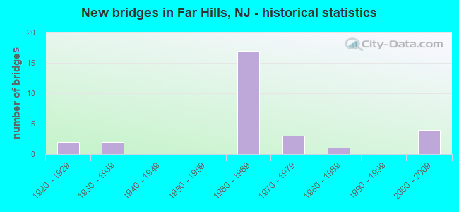
- New bridges - historical statistics
- 21920-1929
- 21930-1939
- 171960-1969
- 31970-1979
- 11980-1989
- 42000-2009

- Reconstructed bridges - Historical Statistics
- 21970-1979
- 11980-1989
- 51990-1999
- 12000-2009


- Bridge Condition - Deck
- 16.7%Very good
- 33.3%Good
- 16.7%Satisfactory
- 22.2%Fair
- 11.1%Poor

- Bridge Condition - Superstructure
- 10.5%Very good
- 42.1%Good
- 21.1%Satisfactory
- 21.1%Fair
- 5.3%Poor

- Bridge Condition - Substructure
- 10.5%Very good
- 10.5%Good
- 36.8%Satisfactory
- 36.8%Fair
- 5.3%Poor

- Bridge Condition - Channel
- 60.0%Satisfactory
- 20.0%Fair
- 20.0%Poor
Find on map >> Show street view
Structure Number: 1808167, Location: 0.2 MI NORTH OF I-287 (Lat: 40.661069, Lng: -74.645561), Route carried "on" structure: US 202, Year Built: 1922, Year Reconstructed: 1975, Status: Open, Structure Length: 2.83m (9.28ft), Average Daily Traffic: 40,935 (year 2019), Truck Traffic: 4%, Average Future Daily Traffic: 49,122 (year 2039), Design Load: HS 20+Mod, Features Intersected: N BRANCH RARITAN RIVER
Minimum Vertical Clearance: 30+ m (98+ ft), Kilometerpoint: 49.487, Lanes on structure: 6, Base Highway Network: Yes, Owner: State Highway Agency, Approaching Roadway Width: 28.0m (91.9ft), Skew: 31 degrees, Material/Design: Steel, Design/Construction: Stringer/Multi-beam, Number Of Spans In Main Unit: 2, Length of Maximum Span: 13.4m (44.0ft), Curb or Sidewalk Widths: Left: 1.8m (5.9ft), Right: 1.8m (5.9ft), Curb-To-Curb Width: 27.7m (90.9ft), Out-to-Out Width: 32.6m (107.0ft)
Condition: Deck: Poor, Superstructure: Fair, Substructure: Fair, Channel: Satisfactory, Operating Rating: 39.0 metric tons, Method Used To Determine Operating Rating: Load Factor (LF), Inventory Rating: 23.6 metric tons, Method Used To Determine Inventory Rating: Load Factor (LF), Structural Evaluation: Somewhat better than minimum adequacy, Deck Geometry: Equal to present desirable criteria, Waterway Adequacy: Equal to present minimum criteria, Approach Roadway Alignment: Better than present minimum criteria, Length Of Structure Improvement: 3.05m (10.01ft), Designated Inspection Frequency: Every 24 months, Underwater Inspection Frequency: Every 48 months, Inspection Date: June 2021, Underwater Inspection Date: May 2019, Bridge Improvement Cost: $3,304,000, Roadway Improvement Cost: $109,000, Total Project Cost: $4,720,000 ( Estimate for 2020), Deck Structure Type: Concrete Cast-file-Place, Wearing Surface/Protective System: Wearing Surface: Bituminous
Find on map >> Show street view
Structure Number: 1808169, Location: 0.53 MILE N OF I-287 (Lat: 40.666061, Lng: -74.643889), Route carried "on" structure: US 202, Year Built: 1976, Status: Open, Structure Length: 4.69m (15.39ft), Average Daily Traffic: 38,989 (year 2019), Truck Traffic: 4%, Average Future Daily Traffic: 48,677 (year 2039), Design Load: HS 20, Features Intersected: A.T.&T SB EXIT ROAD
Minimum Vertical Clearance: 30+ m (98+ ft), Kilometerpoint: 49.954, Lanes on structure: 4, Lanes under structure: 2, Base Highway Network: Yes, Owner: State Highway Agency, Approaching Roadway Width: 22.3m (73.2ft), Skew: 35 degrees, Material/Design: Steel, Design/Construction: Stringer/Multi-beam, Number Of Spans In Main Unit: 3, Length of Maximum Span: 26.2m (86.0ft), Curb or Sidewalk Widths: Left: 1.8m (5.9ft), Right: 1.8m (5.9ft), Curb-To-Curb Width: 22.3m (73.2ft), Out-to-Out Width: 27.5m (90.2ft)
Condition: Deck: Satisfactory, Superstructure: Satisfactory, Substructure: Fair, Operating Rating: 89.8 metric tons, Method Used To Determine Operating Rating: Load Factor (LF), Inventory Rating: 53.5 metric tons, Method Used To Determine Inventory Rating: Load Factor (LF), Structural Evaluation: Somewhat better than minimum adequacy, Deck Geometry: Superior to present desirable criteria, Underclear: Meets minimum limits, Approach Roadway Alignment: Better than present minimum criteria, Designated Inspection Frequency: Every 24 months, Inspection Date: July 2021, Deck Structure Type: Concrete Cast-file-Place, Wearing Surface/Protective System: Wearing Surface: Monolithic Concrete
Find on map >> Show street view
Structure Number: 180915, Location: 1.03 MI N OF US202-206 (Lat: 40.682731, Lng: -74.638511), Route carried "on" structure: US 202, Year Built: 1922, Status: Open, Structure Length: 3.60m (11.81ft), Average Daily Traffic: 6,782 (year 2021), Truck Traffic: 4%, Average Future Daily Traffic: 8,138 (year 2041), Features Intersected: N BRANCH RARITAN RIVER
Minimum Vertical Clearance: 30+ m (98+ ft), Kilometerpoint: 52.368, Lanes on structure: 2, Owner: State Highway Agency, Approaching Roadway Width: 10.7m (35.1ft), Skew: 3 degrees, Material/Design: Steel, Design/Construction: Stringer/Multi-beam, Number Of Spans In Main Unit: 3, Length of Maximum Span: 11.3m (37.1ft), Curb or Sidewalk Widths: Left: 1.7m (5.6ft), Right: 0.0m, Curb-To-Curb Width: 9.0m (29.5ft), Out-to-Out Width: 11.8m (38.7ft)
Condition: Deck: Poor, Superstructure: Fair, Substructure: Poor, Channel: Poor, Inventory Rating: 58.1 metric tons, Method Used To Determine Inventory Rating: Load Factor (LF), Structural Evaluation: Meets minimum limits, Deck Geometry: High priority of replacement, Waterway Adequacy: Superior to present desirable criteria, Approach Roadway Alignment: Equal to present desirable criteria, Length Of Structure Improvement: 4.51m (14.80ft), Designated Inspection Frequency: Every 24 months, Inspection Date: May 2021, Bridge Improvement Cost: $2,864,000, Roadway Improvement Cost: $430,000, Total Project Cost: $3,200,000 ( Estimate for 2021), Deck Structure Type: Concrete Cast-file-Place, Wearing Surface/Protective System: Wearing Surface: Bituminous
Find on map >> Show street view
Structure Number: 181515, Location: .3 MILE NORTH OF I-78 JCT (Lat: 40.646519, Lng: -74.645950), Route carried "on" structure: County highway 620, Year Built: 1964, Year Reconstructed: 2014, Status: Open, Structure Length: 4.60m (15.09ft), Average Daily Traffic: 8,199 (year 2021), Truck Traffic: 3%, Average Future Daily Traffic: 9,839 (year 2041), Design Load: HL 93, Features Intersected: I-287 NB
Minimum Vertical Clearance: 30+ m (98+ ft), Kilometerpoint: 5.858, Lanes on structure: 2, Lanes under structure: 5, Owner: State Highway Agency, Approaching Roadway Width: 9.1m (29.9ft), Material/Design: Steel, Design/Construction: Stringer/Multi-beam, Number Of Spans In Main Unit: 3, Length of Maximum Span: 24.1m (79.1ft), Curb or Sidewalk Widths: Left: 1.8m (5.9ft), Right: 1.8m (5.9ft), Curb-To-Curb Width: 9.1m (29.9ft), Out-to-Out Width: 13.6m (44.6ft)
Condition: Deck: Very good, Superstructure: Good, Substructure: Satisfactory, Operating Rating: 66.1 metric tons, Method Used To Determine Operating Rating: Load and Resistance Factor Rating (LRFR) rating reported by rating factor(RF) method using HL-93 loadings, Inventory Rating: 61.6 metric tons, Method Used To Determine Inventory Rating: Load and Resistance Factor Rating (LRFR) rating reported by rating factor(RF) method using HL-93 loadings, Structural Evaluation: Equal to present minimum criteria, Deck Geometry: High priority of corrective action, Underclear: Somewhat better than minimum adequacy, Approach Roadway Alignment: Equal to present desirable criteria, Length Of Structure Improvement: 4.60m (15.09ft), Designated Inspection Frequency: Every 24 months, Inspection Date: June 2021, Bridge Improvement Cost: $48,000, Roadway Improvement Cost: $100,000, Total Project Cost: $204,000 ( Estimate for 2021), Deck Structure Type: Concrete Cast-file-Place, Wearing Surface/Protective System: Wearing Surface: Monolithic Concrete, Deck Protection: Epoxy Coated Reinforcing
Find on map >> Show street view
Structure Number: 1815154, Location: AT I-287 EXIT 22 (Lat: 40.657481, Lng: -74.644389), Route carried "on" structure: Interstate 287, Year Built: 1965, Year Reconstructed: 1996, Status: Open, Structure Length: 5.06m (16.60ft), Average Daily Traffic: 39,690 (year 2021), Truck Traffic: 9%, Average Future Daily Traffic: 48,429 (year 2041), Design Load: HS 20, Features Intersected: US 202-206
Minimum Vertical Clearance: 30+ m (98+ ft), Kilometerpoint: 35.744, Lanes on structure: 5, Lanes under structure: 4, Base Highway Network: Yes, Owner: State Highway Agency, Approaching Roadway Width: 20.4m (66.9ft), Skew: 3 degrees, Material/Design: Steel, Design/Construction: Stringer/Multi-beam, Number Of Spans In Main Unit: 3, Length of Maximum Span: 27.7m (90.9ft), Curb-To-Curb Width: 20.4m (66.9ft), Out-to-Out Width: 21.5m (70.5ft)
Condition: Deck: Fair, Superstructure: Poor, Substructure: Satisfactory, Operating Rating: 82.6 metric tons, Method Used To Determine Operating Rating: Load Factor (LF), Inventory Rating: 49.0 metric tons, Method Used To Determine Inventory Rating: Load Factor (LF), Structural Evaluation: Meets minimum limits, Deck Geometry: High priority of corrective action, Underclear: High priority of corrective action, Approach Roadway Alignment: Equal to present desirable criteria, Length Of Structure Improvement: 2.77m (9.09ft), Designated Inspection Frequency: Every 24 months, Other Special Inspection Frequency: Every 3 months, Inspection Date: July 2021, Other Special Inspection Date: January 2022, Bridge Improvement Cost: $570,000, Roadway Improvement Cost: $104,000, Total Project Cost: $990,000 ( Estimate for 2021), Deck Structure Type: Concrete Cast-file-Place, Wearing Surface/Protective System: Wearing Surface: Bituminous, Deck Protection: Epoxy Coated Reinforcing
Find on map >> Show street view
Structure Number: 1815155, Location: AT I-287 EXIT 22 (Lat: 40.658181, Lng: -74.644631), Route carried "on" structure: Interstate 287, Year Built: 1964, Year Reconstructed: 1997, Status: Open, Structure Length: 4.94m (16.21ft), Average Daily Traffic: 44,113 (year 2021), Truck Traffic: 9%, Average Future Daily Traffic: 52,936 (year 2041), Design Load: HS 25 or greater, Features Intersected: US 202-206
Minimum Vertical Clearance: 30+ m (98+ ft), Kilometerpoint: 35.744, Lanes on structure: 3, Lanes under structure: 4, Base Highway Network: Yes, Owner: State Highway Agency, Approaching Roadway Width: 17.7m (58.1ft), Skew: 3 degrees, Material/Design: Steel, Design/Construction: Stringer/Multi-beam, Number Of Spans In Main Unit: 3, Length of Maximum Span: 27.4m (89.9ft), Curb-To-Curb Width: 16.8m (55.1ft), Out-to-Out Width: 17.8m (58.4ft)
Condition: Deck: Good, Superstructure: Satisfactory, Substructure: Satisfactory, Operating Rating: 78.9 metric tons, Method Used To Determine Operating Rating: Load Factor (LF), Inventory Rating: 47.2 metric tons, Method Used To Determine Inventory Rating: Load Factor (LF), Structural Evaluation: Equal to present minimum criteria, Deck Geometry: Equal to present minimum criteria, Underclear: High priority of corrective action, Approach Roadway Alignment: Equal to present desirable criteria, Designated Inspection Frequency: Every 24 months, Inspection Date: June 2021, Bridge Improvement Cost: $63,000, Total Project Cost: $76,000 ( Estimate for 2021), Deck Structure Type: Concrete Cast-file-Place, Wearing Surface/Protective System: Wearing Surface: Latex Concrete
Find on map >> Show street view
Structure Number: 1815157, Location: 2.5 MI NORTH OF I-78 JCT (Lat: 40.660000, Lng: -74.643331), Route carried "on" structure: Interstate 287, Year Built: 1964, Year Reconstructed: 1997, Status: Open, Structure Length: 3.72m (12.20ft), Average Daily Traffic: 44,506 (year 2020), Truck Traffic: 11%, Average Future Daily Traffic: 53,407 (year 2040), Design Load: HS 25 or greater, Features Intersected: LAYTON ROAD
Minimum Vertical Clearance: 30+ m (98+ ft), Kilometerpoint: 38.093, Lanes on structure: 4, Lanes under structure: 2, Base Highway Network: Yes, Owner: State Highway Agency, Approaching Roadway Width: 19.2m (63.0ft), Skew: 1 degrees, Material/Design: Prestressed concrete, Design/Construction: Stringer/Multi-beam, Number Of Spans In Main Unit: 3, Length of Maximum Span: 17.1m (56.1ft), Curb-To-Curb Width: 19.2m (63.0ft), Out-to-Out Width: 20.3m (66.6ft)
Condition: Deck: Very good, Superstructure: Good, Substructure: Satisfactory, Operating Rating: 49.0 metric tons, Method Used To Determine Operating Rating: Load Factor (LF), Inventory Rating: 29.0 metric tons, Method Used To Determine Inventory Rating: Load Factor (LF), Structural Evaluation: Equal to present minimum criteria, Deck Geometry: Somewhat better than minimum adequacy, Underclear: Equal to present minimum criteria, Approach Roadway Alignment: Equal to present desirable criteria, Designated Inspection Frequency: Every 24 months, Inspection Date: July 2020, Deck Structure Type: Concrete Cast-file-Place, Wearing Surface/Protective System: Wearing Surface: Bituminous, Deck Protection: Epoxy Coated Reinforcing
Find on map >> Show street view
Structure Number: 1815158, Location: 1.46 MI N OF EXIT 22 (Lat: 40.671131, Lng: -74.624531), Route carried "on" structure: Interstate 287, Year Built: 1964, Year Reconstructed: 1997, Status: Open, Structure Length: 3.78m (12.40ft), Average Daily Traffic: 44,503 (year 2020), Truck Traffic: 9%, Average Future Daily Traffic: 53,403 (year 2040), Design Load: HS 20, Features Intersected: LAYTON ROAD
Minimum Vertical Clearance: 30.45m (99.90ft), Kilometerpoint: 38.093, Lanes on structure: 3, Lanes under structure: 2, Base Highway Network: Yes, Owner: State Highway Agency, Approaching Roadway Width: 16.8m (55.1ft), Skew: 1 degrees, Material/Design: Prestressed concrete, Design/Construction: Stringer/Multi-beam, Number Of Spans In Main Unit: 3, Length of Maximum Span: 17.7m (58.1ft), Curb-To-Curb Width: 16.8m (55.1ft), Out-to-Out Width: 17.8m (58.4ft)
Condition: Deck: Good, Superstructure: Satisfactory, Substructure: Satisfactory, Operating Rating: 49.0 metric tons, Method Used To Determine Operating Rating: Load Factor (LF), Inventory Rating: 29.0 metric tons, Method Used To Determine Inventory Rating: Load Factor (LF), Structural Evaluation: Equal to present minimum criteria, Deck Geometry: Equal to present minimum criteria, Underclear: Equal to present minimum criteria, Approach Roadway Alignment: Equal to present desirable criteria, Designated Inspection Frequency: Every 24 months, Inspection Date: July 2020, Deck Structure Type: Concrete Cast-file-Place, Wearing Surface/Protective System: Wearing Surface: Latex Concrete, Deck Protection: Epoxy Coated Reinforcing
Find on map >> Show street view
Structure Number: 1815159, Location: 1.6 MI East of US 202 (Lat: 40.673169, Lng: -74.612461), Route carried "on" structure: County highway 512, Year Built: 1964, Year Reconstructed: 1997, Status: Open, Structure Length: 4.39m (14.40ft), Average Daily Traffic: 4,182 (year 2021), Truck Traffic: 3%, Average Future Daily Traffic: 5,018 (year 2041), Design Load: HS 20, Features Intersected: I-287 NORTHBOUND, Facility Carried by Structure: LIBERTY CORNER RD
Minimum Vertical Clearance: 30+ m (98+ ft), Kilometerpoint: 25.486, Lanes on structure: 2, Lanes under structure: 4, Owner: State Highway Agency, Approaching Roadway Width: 9.1m (29.9ft), Skew: 2 degrees, Material/Design: Steel, Design/Construction: Stringer/Multi-beam, Number Of Spans In Main Unit: 1, Number Of Approach Spans: 1, Length of Maximum Span: 31.1m (102.0ft), Curb or Sidewalk Widths: Left: 0.0m, Right: 2.4m (7.9ft), Curb-To-Curb Width: 9.1m (29.9ft), Out-to-Out Width: 12.2m (40.0ft)
Condition: Deck: Good, Superstructure: Good, Substructure: Satisfactory, Operating Rating: 50.8 metric tons, Method Used To Determine Operating Rating: Load Factor (LF), Inventory Rating: 29.9 metric tons, Method Used To Determine Inventory Rating: Load Factor (LF), Structural Evaluation: Equal to present minimum criteria, Deck Geometry: Meets minimum limits, Underclear: High priority of corrective action, Approach Roadway Alignment: Equal to present desirable criteria, Length Of Structure Improvement: 4.39m (14.40ft), Designated Inspection Frequency: Every 24 months, Inspection Date: May 2021, Roadway Improvement Cost: $58,000, Total Project Cost: $58,000 ( Estimate for 2021), Deck Structure Type: Concrete Cast-file-Place, Wearing Surface/Protective System: Wearing Surface: Latex Concrete
Find on map >> Show street view
Structure Number: 181516, Location: 3.23 MI NORTH OF I78 (Lat: 40.673531, Lng: -74.613039), Route carried "on" structure: County highway 512, Year Built: 1964, Year Reconstructed: 1994, Status: Open, Structure Length: 4.45m (14.60ft), Average Daily Traffic: 4,182 (year 2021), Truck Traffic: 3%, Average Future Daily Traffic: 5,018 (year 2041), Design Load: HS 20, Features Intersected: I-287 SB, Facility Carried by Structure: LIBERTY CORNER RD.
Minimum Vertical Clearance: 30+ m (98+ ft), Kilometerpoint: 25.421, Lanes on structure: 2, Lanes under structure: 3, Owner: State Highway Agency, Approaching Roadway Width: 9.1m (29.9ft), Skew: 2 degrees, Material/Design: Prestressed concrete, Design/Construction: Stringer/Multi-beam, Number Of Spans In Main Unit: 3, Length of Maximum Span: 21.3m (69.9ft), Curb or Sidewalk Widths: Left: 0.6m (2.0ft), Right: 1.8m (5.9ft), Curb-To-Curb Width: 9.1m (29.9ft), Out-to-Out Width: 12.2m (40.0ft)
Condition: Deck: Fair, Superstructure: Fair, Substructure: Fair, Operating Rating: 51.7 metric tons, Method Used To Determine Operating Rating: Load Factor (LF), Inventory Rating: 30.8 metric tons, Method Used To Determine Inventory Rating: Load Factor (LF), Structural Evaluation: Somewhat better than minimum adequacy, Deck Geometry: Meets minimum limits, Underclear: High priority of corrective action, Approach Roadway Alignment: Equal to present desirable criteria, Length Of Structure Improvement: 4.45m (14.60ft), Designated Inspection Frequency: Every 24 months, Inspection Date: May 2021, Roadway Improvement Cost: $36,000, Total Project Cost: $36,000 ( Estimate for 2021), Deck Structure Type: Concrete Cast-file-Place, Wearing Surface/Protective System: Wearing Surface: Monolithic Concrete
Find on map >> Show street view
Structure Number: 1815161, Location: 3.8 MI N OF I-78 JCT (Lat: 40.678289, Lng: -74.602439), Route carried "on" structure: City street , Year Built: 1965, Status: Open, Structure Length: 6.86m (22.51ft), Average Daily Traffic: 2,988 (year 2021), Truck Traffic: 1%, Average Future Daily Traffic: 3,586 (year 2041), Design Load: H 20, Features Intersected: I-287, Facility Carried by Structure: MINE BROOK ROAD
Minimum Vertical Clearance: 30+ m (98+ ft), Kilometerpoint: 0.000, Lanes on structure: 2, Lanes under structure: 6, Owner: State Highway Agency, Approaching Roadway Width: 9.1m (29.9ft), Material/Design: Prestressed concrete, Design/Construction: Stringer/Multi-beam, Number Of Spans In Main Unit: 4, Length of Maximum Span: 23.5m (77.1ft), Curb or Sidewalk Widths: Left: 0.5m (1.6ft), Right: 1.8m (5.9ft), Curb-To-Curb Width: 9.1m (29.9ft), Out-to-Out Width: 12.2m (40.0ft)
Condition: Deck: Fair, Superstructure: Good, Substructure: Fair, Operating Rating: 49.9 metric tons, Method Used To Determine Operating Rating: Load Factor (LF), Inventory Rating: 29.0 metric tons, Method Used To Determine Inventory Rating: Load Factor (LF), Structural Evaluation: Somewhat better than minimum adequacy, Deck Geometry: Meets minimum limits, Underclear: Somewhat better than minimum adequacy, Approach Roadway Alignment: Better than present minimum criteria, Designated Inspection Frequency: Every 24 months, Inspection Date: May 2021, Deck Structure Type: Concrete Cast-file-Place, Wearing Surface/Protective System: Wearing Surface: Monolithic Concrete
Find on map >> Show street view
Structure Number: 1815162, Location: 0.7 MI S OF I-287 EXIT 26 (Lat: 40.683939, Lng: -74.588889), Route carried "on" structure: City street , Year Built: 1965, Status: Open, Structure Length: 6.34m (20.80ft), Average Daily Traffic: 2,690 (year 2020), Truck Traffic: 1%, Average Future Daily Traffic: 3,230 (year 2040), Design Load: HS 20+Mod, Features Intersected: I-287, Facility Carried by Structure: ANNIN ROAD
Minimum Vertical Clearance: 30+ m (98+ ft), Kilometerpoint: 0.000, Lanes on structure: 2, Lanes under structure: 6, Owner: State Highway Agency, Approaching Roadway Width: 9.1m (29.9ft), Skew: 1 degrees, Material/Design: Prestressed concrete, Design/Construction: Stringer/Multi-beam, Number Of Spans In Main Unit: 4, Length of Maximum Span: 24.1m (79.1ft), Curb or Sidewalk Widths: Left: 0.5m (1.6ft), Right: 1.8m (5.9ft), Curb-To-Curb Width: 9.1m (29.9ft), Out-to-Out Width: 12.2m (40.0ft)
Condition: Deck: Fair, Superstructure: Satisfactory, Substructure: Satisfactory, Inventory Rating: 58.1 metric tons, Method Used To Determine Inventory Rating: Allowable Stress (AS), Structural Evaluation: Equal to present minimum criteria, Deck Geometry: Meets minimum limits, Underclear: Somewhat better than minimum adequacy, Approach Roadway Alignment: Better than present minimum criteria, Designated Inspection Frequency: Every 24 months, Inspection Date: May 2020, Deck Structure Type: Concrete Cast-file-Place, Wearing Surface/Protective System: Wearing Surface: Bituminous
Find on map >> Show street view
Structure Number: 18E1203, Location: 0.3 MI EAST of US 202 (Lat: 40.682339, Lng: -74.630100), Route carried "on" structure: County highway 512, Year Built: 1930, Status: Open, Structure Length: 0.73m (2.40ft), Average Daily Traffic: 6,496 (year 2021), Truck Traffic: 3%, Average Future Daily Traffic: 7,796 (year 2041), Design Load: H 20, Features Intersected: MINE BROOK
Minimum Vertical Clearance: 30+ m (98+ ft), Kilometerpoint: 23.368, Lanes on structure: 2, Owner: County Highway Agency, Approaching Roadway Width: 7.8m (25.6ft), Skew: 1 degrees, Material/Design: Concrete, Design/Construction: Arch - Deck, Number Of Spans In Main Unit: 1, Length of Maximum Span: 7.3m (24.0ft), Curb-To-Curb Width: 7.2m (23.6ft), Out-to-Out Width: 9.1m (29.9ft)
Condition: Superstructure: Fair, Substructure: Fair, Channel: Fair, Operating Rating: 28.1 metric tons, Method Used To Determine Operating Rating: Field evaluation and documented engineering judgment, Inventory Rating: 17.2 metric tons, Method Used To Determine Inventory Rating: Field evaluation and documented engineering judgment, Structural Evaluation: Meets minimum limits, Deck Geometry: High priority of replacement, Waterway Adequacy: Superior to present desirable criteria, Approach Roadway Alignment: Equal to present desirable criteria, Length Of Structure Improvement: 1.40m (4.59ft), Designated Inspection Frequency: Every 24 months, Inspection Date: September 2021, Bridge Improvement Cost: $229,000, Roadway Improvement Cost: $106,000, Total Project Cost: $484,000 ( Estimate for 2021)
Find on map >> Show street view
Structure Number: 18E1205, Location: At Int. Peapack Rd CR512 (Lat: 40.691450, Lng: -74.647831), Route carried "on" structure: City street , Year Built: 2006, Status: Open, Structure Length: 1.52m (4.99ft), Average Daily Traffic: 1,061 (year 2021), Truck Traffic: 1%, Average Future Daily Traffic: 1,273 (year 2041), Design Load: HS 25 or greater, Features Intersected: PEAPACK BROOK, Facility Carried by Structure: OLD DUTCH ROAD
Minimum Vertical Clearance: 30+ m (98+ ft), Kilometerpoint: 0.000, Lanes on structure: 2, Owner: County Highway Agency, Approaching Roadway Width: 7.3m (24.0ft), Skew: 3 degrees, Material/Design: Steel, Design/Construction: Stringer/Multi-beam, Number Of Spans In Main Unit: 1, Length of Maximum Span: 13.4m (44.0ft), Curb-To-Curb Width: 7.3m (24.0ft), Out-to-Out Width: 8.4m (27.6ft)
Condition: Deck: Good, Superstructure: Good, Substructure: Very good, Channel: Poor, Inventory Rating: 68.0 metric tons, Method Used To Determine Inventory Rating: Load Factor (LF), Structural Evaluation: Better than present minimum criteria, Deck Geometry: Meets minimum limits, Waterway Adequacy: Somewhat better than minimum adequacy, Approach Roadway Alignment: Equal to present desirable criteria, Designated Inspection Frequency: Every 24 months, Inspection Date: October 2021, Deck Structure Type: Concrete Cast-file-Place, Wearing Surface/Protective System: Deck Protection: Galvanized Reinforcing
Find on map >> Show street view
Structure Number: 18E1206, Location: 0.77 mi W of US 202 (Lat: 40.691331, Lng: -74.647169), Route carried "on" structure: County highway 512, Year Built: 2006, Status: Open, Structure Length: 1.77m (5.81ft), Average Daily Traffic: 6,495 (year 2021), Truck Traffic: 3%, Average Future Daily Traffic: 7,794 (year 2041), Design Load: HS 25 or greater, Features Intersected: NORTH BR RARITAN RIVER
Minimum Vertical Clearance: 30+ m (98+ ft), Kilometerpoint: 21.276, Lanes on structure: 2, Owner: County Highway Agency, Approaching Roadway Width: 11.0m (36.1ft), Skew: 1 degrees, Material/Design: Steel, Design/Construction: Truss - Thru, Number Of Spans In Main Unit: 1, Length of Maximum Span: 16.5m (54.1ft), Curb-To-Curb Width: 11.0m (36.1ft), Out-to-Out Width: 12.0m (39.4ft)
Condition: Deck: Satisfactory, Superstructure: Good, Substructure: Fair, Channel: Satisfactory, Operating Rating: 51.7 metric tons, Method Used To Determine Operating Rating: Load Factor (LF), Inventory Rating: 30.8 metric tons, Method Used To Determine Inventory Rating: Load Factor (LF), Structural Evaluation: Somewhat better than minimum adequacy, Deck Geometry: Meets minimum limits, Waterway Adequacy: Equal to present minimum criteria, Approach Roadway Alignment: Better than present minimum criteria, Designated Inspection Frequency: Every 24 months, Critical Feature Inspection Frequency: Every 24 months, Inspection Date: September 2021, Critical Feature Inspection Date: September 2021, Deck Structure Type: Concrete Cast-file-Place, Wearing Surface/Protective System: Deck Protection: Galvanized Reinforcing
Find on map >> Show street view
Structure Number: 18G1103, Location: AT VALLEY ROAD JCT. (Lat: 40.659639, Lng: -74.576631), Route carried "on" structure: County highway 525, Year Built: 1985, Status: Open, Structure Length: 1.98m (6.50ft), Average Daily Traffic: 23,412 (year 2021), Truck Traffic: 4%, Average Future Daily Traffic: 28,567 (year 2041), Design Load: HS 20+Mod, Features Intersected: HARRISON'S BROOK
Minimum Vertical Clearance: 30+ m (98+ ft), Kilometerpoint: 11.603, Lanes on structure: 3, Owner: County Highway Agency, Approaching Roadway Width: 14.0m (45.9ft), Skew: 5 degrees, Material/Design: Concrete, Design/Construction: Culvert, Number Of Spans In Main Unit: 2, Length of Maximum Span: 7.9m (25.9ft), Curb or Sidewalk Widths: Left: 1.5m (4.9ft), Right: 1.5m (4.9ft), Curb-To-Curb Width: 14.0m (45.9ft), Out-to-Out Width: 33.5m (109.9ft)
Condition: Channel: Satisfactory, Culverts: Good, Operating Rating: 40.8 metric tons, Method Used To Determine Operating Rating: Load Factor (LF), Inventory Rating: 24.5 metric tons, Method Used To Determine Inventory Rating: Load Factor (LF), Structural Evaluation: Equal to present minimum criteria, Deck Geometry: Somewhat better than minimum adequacy, Waterway Adequacy: Equal to present minimum criteria, Approach Roadway Alignment: Equal to present desirable criteria, Designated Inspection Frequency: Every 24 months, Inspection Date: September 2021
Find on map >> Show street view
Structure Number: 18G1107, Location: 0.71 MI SO.of CR 512 (Lat: 40.656181, Lng: -74.592531), Route carried "on" structure: City street , Year Built: 2000, Status: Open, Structure Length: 2.23m (7.32ft), Average Daily Traffic: 50,305 (year 2021), Truck Traffic: 3%, Average Future Daily Traffic: 6,366 (year 2041), Design Load: HS 25 or greater, Features Intersected: DEAD RIVER, Facility Carried by Structure: SOMERVILLE ROAD
Minimum Vertical Clearance: 30+ m (98+ ft), Kilometerpoint: 2.913, Lanes on structure: 2, Owner: County Highway Agency, Approaching Roadway Width: 10.1m (33.1ft), Skew: 2 degrees, Material/Design: Steel, Design/Construction: Stringer/Multi-beam, Number Of Spans In Main Unit: 1, Length of Maximum Span: 20.7m (67.9ft), Curb or Sidewalk Widths: Left: 1.8m (5.9ft), Right: 0.1m (0.3ft), Curb-To-Curb Width: 10.1m (33.1ft), Out-to-Out Width: 13.0m (42.7ft)
Condition: Deck: Good, Superstructure: Very good, Substructure: Good, Channel: Satisfactory, Inventory Rating: 63.5 metric tons, Method Used To Determine Inventory Rating: Load Factor (LF), Structural Evaluation: Better than present minimum criteria, Deck Geometry: Meets minimum limits, Waterway Adequacy: Equal to present minimum criteria, Approach Roadway Alignment: Equal to present minimum criteria, Designated Inspection Frequency: Every 24 months, Inspection Date: September 2021, Deck Structure Type: Concrete Cast-file-Place, Wearing Surface/Protective System: Wearing Surface: Monolithic Concrete, Deck Protection: Galvanized Reinforcing
Find on map >> Show street view
Structure Number: 18G1109, Location: 0.6 MI NO CHURCH STREET (Lat: 40.672781, Lng: -74.592750), Route carried "on" structure: City street , Year Built: 2005, Status: Open, Structure Length: 0.79m (2.59ft), Average Daily Traffic: 1,128 (year 2021), Truck Traffic: 1%, Average Future Daily Traffic: 1,353 (year 2040), Design Load: HS 25 or greater, Features Intersected: DEAD RIVER, Facility Carried by Structure: MINE BROOK ROAD
Minimum Vertical Clearance: 30+ m (98+ ft), Kilometerpoint: 0.000, Lanes on structure: 2, Owner: County Highway Agency, Approaching Roadway Width: 9.1m (29.9ft), Material/Design: Wood or Timber, Design/Construction: Slab, Number Of Spans In Main Unit: 1, Length of Maximum Span: 6.7m (22.0ft), Curb-To-Curb Width: 9.1m (29.9ft), Out-to-Out Width: 9.8m (32.2ft)
Condition: Deck: Very good, Superstructure: Very good, Substructure: Very good, Channel: Satisfactory, Operating Rating: 88.9 metric tons, Method Used To Determine Operating Rating: Allowable Stress (AS), Inventory Rating: 63.5 metric tons, Method Used To Determine Inventory Rating: Allowable Stress (AS), Structural Evaluation: Equal to present desirable criteria, Deck Geometry: Somewhat better than minimum adequacy, Waterway Adequacy: Better than present minimum criteria, Approach Roadway Alignment: Equal to present minimum criteria, Designated Inspection Frequency: Every 24 months, Inspection Date: September 2021, Deck Structure Type: Wood or Timber, Wearing Surface/Protective System: Wearing Surface: Bituminous
Find on map >> Show street view
Structure Number: 18G111, Location: 1.53 MI NORTH OF I-78 (Lat: 40.667811, Lng: -74.573669), Route carried "on" structure: County highway 525, Year Built: 1971, Status: Open, Structure Length: 1.62m (5.31ft), Average Daily Traffic: 23,412 (year 2021), Truck Traffic: 4%, Average Future Daily Traffic: 28,567 (year 2041), Design Load: HS 20+Mod, Features Intersected: HARRISON'S BROOK
Minimum Vertical Clearance: 30+ m (98+ ft), Kilometerpoint: 12.601, Lanes on structure: 2, Owner: County Highway Agency, Approaching Roadway Width: 14.0m (45.9ft), Skew: 1 degrees, Material/Design: Prestressed concrete, Design/Construction: Box Beam or Girders - Multiple, Number Of Spans In Main Unit: 1, Length of Maximum Span: 14.3m (46.9ft), Curb or Sidewalk Widths: Left: 1.8m (5.9ft), Right: 1.8m (5.9ft), Curb-To-Curb Width: 14.6m (47.9ft), Out-to-Out Width: 19.1m (62.7ft)
Condition: Deck: Satisfactory, Superstructure: Good, Substructure: Good, Channel: Fair, Operating Rating: 41.7 metric tons, Method Used To Determine Operating Rating: Load Factor (LF), Inventory Rating: 24.5 metric tons, Method Used To Determine Inventory Rating: Load Factor (LF), Structural Evaluation: Equal to present minimum criteria, Deck Geometry: Superior to present desirable criteria, Waterway Adequacy: Somewhat better than minimum adequacy, Approach Roadway Alignment: Equal to present desirable criteria, Length Of Structure Improvement: 1.58m (5.18ft), Designated Inspection Frequency: Every 24 months, Inspection Date: September 2021, Bridge Improvement Cost: $480,000, Total Project Cost: $480,000 ( Estimate for 2021), Deck Structure Type: Concrete Cast-file-Place, Wearing Surface/Protective System: Wearing Surface: Monolithic Concrete
Find on map >> Show street view
Structure Number: 18G1201, Location: 0.35 MILE FROM RT 525 (Lat: 40.674361, Lng: -74.570061), Route carried "on" structure: County highway 640, Year Built: 1930, Year Reconstructed: 1982, Status: Open, Structure Length: 0.79m (2.59ft), Average Daily Traffic: 7,527 (year 2021), Truck Traffic: 3%, Average Future Daily Traffic: 9,184 (year 2041), Design Load: HS 20, Features Intersected: HARRISONS BROOK
Minimum Vertical Clearance: 30+ m (98+ ft), Kilometerpoint: 1.593, Lanes on structure: 2, Owner: County Highway Agency, Approaching Roadway Width: 10.1m (33.1ft), Skew: 2 degrees, Material/Design: Wood or Timber, Design/Construction: Slab, Number Of Spans In Main Unit: 1, Length of Maximum Span: 7.0m (23.0ft), Curb-To-Curb Width: 10.0m (32.8ft), Out-to-Out Width: 10.5m (34.4ft)
Condition: Deck: Good, Superstructure: Good, Substructure: Fair, Channel: Satisfactory, Operating Rating: 34.5 metric tons, Method Used To Determine Operating Rating: Allowable Stress (AS), Inventory Rating: 21.8 metric tons, Method Used To Determine Inventory Rating: Allowable Stress (AS), Structural Evaluation: Somewhat better than minimum adequacy, Deck Geometry: Meets minimum limits, Waterway Adequacy: Equal to present minimum criteria, Approach Roadway Alignment: Equal to present minimum criteria, Designated Inspection Frequency: Every 24 months, Inspection Date: September 2021, Deck Structure Type: Wood or Timber, Wearing Surface/Protective System: Wearing Surface: Bituminous
Find on map >> Show street view
Structure Number: 1808169, Location: 0.53 MILE N OF I-287 (Lat: 40.666061, Lng: -74.643889), Route carried "under" structure: Other road , Year Built: 1976, Structure Length: 0. m, Average Daily Traffic: 1,238 (year 2019), Truck Traffic: 1%, Features Intersected: A.T.&T SB EXIT ROAD, Facility Carried by Structure: US 202-206
Minimum Vertical Clearance: 4.55m (14.93ft), Kilometerpoint: 0.000, Lanes on structure: 4, Lanes under structure: 2, Material/Design: Steel, Design/Construction: Stringer/Multi-beam, Length of Maximum Span: 26.2m (86.0ft)
Find on map >> Show street view
Structure Number: 1815154, Location: AT I-287 EXIT 22 (Lat: 40.657481, Lng: -74.644389), Route carried "under" structure: US 202, Year Built: 1965, Structure Length: 0. m, Average Daily Traffic: 39,787 (year 2021), Truck Traffic: 4%, Features Intersected: US 202-206, Facility Carried by Structure: I-287 NORTHBOUND
Minimum Vertical Clearance: 4.65m (15.26ft), Kilometerpoint: 49.101, Lanes on structure: 5, Lanes under structure: 4, Material/Design: Steel, Design/Construction: Stringer/Multi-beam, Length of Maximum Span: 27.7m (90.9ft)
Find on map >> Show street view
Structure Number: 1815155, Location: AT I-287 EXIT 22 (Lat: 40.658181, Lng: -74.644631), Route carried "under" structure: US 202, Year Built: 1964, Structure Length: 0. m, Average Daily Traffic: 39,784 (year 2021), Truck Traffic: 4%, Features Intersected: US 202-206, Facility Carried by Structure: I-287 SB
Minimum Vertical Clearance: 4.90m (16.08ft), Kilometerpoint: 49.101, Lanes on structure: 3, Lanes under structure: 4, Material/Design: Steel, Design/Construction: Stringer/Multi-beam, Length of Maximum Span: 27.4m (89.9ft)
Find on map >> Show street view
Structure Number: 1815157, Location: 2.5 MI NORTH OF I-78 JCT (Lat: 40.660000, Lng: -74.643331), Route carried "under" structure: City street , Year Built: 1964, Structure Length: 0. m, Average Daily Traffic: 1,408 (year 2020), Truck Traffic: 1%, Features Intersected: LAYTON ROAD, Facility Carried by Structure: I-287 NB
Minimum Vertical Clearance: 4.60m (15.09ft), Kilometerpoint: 0.000, Lanes on structure: 4, Lanes under structure: 2, Material/Design: Prestressed concrete, Design/Construction: Stringer/Multi-beam, Length of Maximum Span: 17.1m (56.1ft)
Find on map >> Show street view
Structure Number: 1815158, Location: 1.46 MI N OF EXIT 22 (Lat: 40.671131, Lng: -74.624531), Route carried "under" structure: City street , Year Built: 1964, Structure Length: 0. m, Average Daily Traffic: 2,122 (year 2020), Truck Traffic: 1%, Features Intersected: LAYTON ROAD, Facility Carried by Structure: I-287 SB
Minimum Vertical Clearance: 4.62m (15.16ft), Kilometerpoint: 0.000, Lanes on structure: 3, Lanes under structure: 2, Material/Design: Prestressed concrete, Design/Construction: Stringer/Multi-beam, Length of Maximum Span: 17.7m (58.1ft)
Find on map >> Show street view
Structure Number: 1815159, Location: 1.6 MI East of US 202 (Lat: 40.673169, Lng: -74.612461), Route carried "under" structure: Interstate 287, Year Built: 1964, Structure Length: 0. m, Average Daily Traffic: 45,074 (year 2021), Truck Traffic: 9%, Features Intersected: I-287 NORTHBOUND, Facility Carried by Structure: LIBERTY CORNER RD
Minimum Vertical Clearance: 4.98m (16.34ft), Kilometerpoint: 39.171, Lanes on structure: 2, Lanes under structure: 4, Material/Design: Steel, Design/Construction: Stringer/Multi-beam, Length of Maximum Span: 31.1m (102.0ft)
Find on map >> Show street view
Structure Number: 181516, Location: 3.23 MI NORTH OF I78 (Lat: 40.673531, Lng: -74.613039), Route carried "under" structure: Interstate 287, Year Built: 1964, Structure Length: 0. m, Average Daily Traffic: 44,941 (year 2021), Truck Traffic: 9%, Features Intersected: I-287 SB, Facility Carried by Structure: LIBERTY CORNER RD.
Minimum Vertical Clearance: 5.00m (16.40ft), Kilometerpoint: 39.171, Lanes on structure: 2, Lanes under structure: 3, Material/Design: Prestressed concrete, Design/Construction: Stringer/Multi-beam, Length of Maximum Span: 21.3m (69.9ft)
Find on map >> Show street view
Structure Number: 1815161, Location: 3.8 MI N OF I-78 JCT (Lat: 40.678289, Lng: -74.602439), Route carried "under" structure: Interstate 287, Year Built: 1965, Structure Length: 0. m, Average Daily Traffic: 118,259 (year 2021), Truck Traffic: 9%, Features Intersected: I-287, Facility Carried by Structure: MINE BROOK ROAD
Minimum Vertical Clearance: 5.26m (17.26ft), Kilometerpoint: 40.169, Lanes on structure: 2, Lanes under structure: 6, Material/Design: Prestressed concrete, Design/Construction: Stringer/Multi-beam, Length of Maximum Span: 23.5m (77.1ft)
Find on map >> Show street view
Structure Number: 1815162, Location: 0.7 MI S OF I-287 EXIT 26 (Lat: 40.683939, Lng: -74.588889), Route carried "under" structure: Interstate 287, Year Built: 1965, Structure Length: 0. m, Average Daily Traffic: 117,100 (year 2020), Truck Traffic: 9%, Features Intersected: I-287, Facility Carried by Structure: ANNIN ROAD
Minimum Vertical Clearance: 5.06m (16.60ft), Kilometerpoint: 41.489, Lanes on structure: 2, Lanes under structure: 6, Material/Design: Prestressed concrete, Design/Construction: Stringer/Multi-beam, Length of Maximum Span: 24.1m (79.1ft)