Bridge Statistics for Farmington, Pennsylvania (PA)
Condition, Traffic, Stress, Structural Evaluation, Project Costs
- National Bridge Inventory (NBI) Statistics
- 17Number of bridges
- 112ft / 34.0mTotal length
- $965,000Total costs
- 29,452Total average daily traffic
- 2,816Total average daily truck traffic
- 39,012Total future (year 2012) average daily traffic
- National Bridge Inventory (NBI) Registered Bridges for Farmington
- No street view available for this location
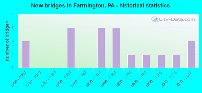
- New bridges - historical statistics
- 21900-1909
- 31930-1939
- 31950-1959
- 31960-1969
- 11970-1979
- 11980-1989
- 11990-1999
- 12000-2009
- 22010-2019
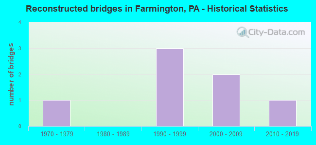
- Reconstructed bridges - Historical Statistics
- 11970-1979
- 01980-1989
- 31990-1999
- 22000-2009
- 12010-2019
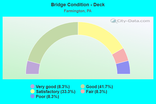
- Bridge Condition - Deck
- 8.3%Very good
- 41.7%Good
- 33.3%Satisfactory
- 8.3%Fair
- 8.3%Poor
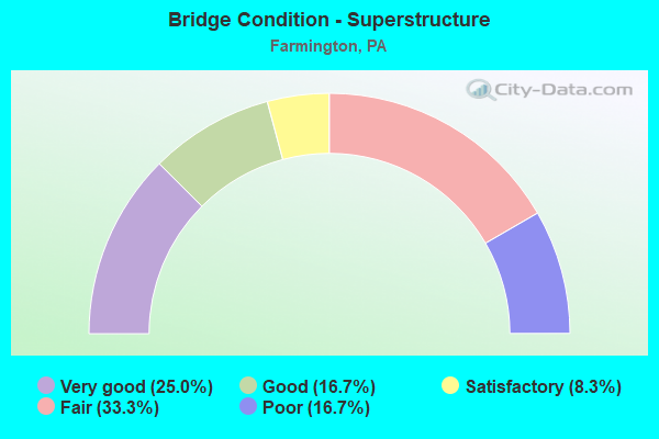
- Bridge Condition - Superstructure
- 25.0%Very good
- 16.7%Good
- 8.3%Satisfactory
- 33.3%Fair
- 16.7%Poor
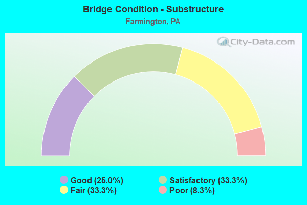
- Bridge Condition - Substructure
- 25.0%Good
- 33.3%Satisfactory
- 33.3%Fair
- 8.3%Poor
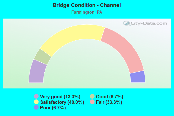
- Bridge Condition - Channel
- 13.3%Very good
- 6.7%Good
- 40.0%Satisfactory
- 33.3%Fair
- 6.7%Poor

- Bridge Condition - Culverts
- 40.0%Very good
- 40.0%Good
- 20.0%Poor
Find on map >> Show street view
Structure Number: 96, Location: @ County Line (Lat: 40.216931, Lng: -79.843053), Route carried "on" structure: State highway 136, Year Built: 1959, Status: Open, Structure Length: 4.60m (15.09ft), Average Daily Traffic: 3,638 (year 2022), Truck Traffic: 6%, Average Future Daily Traffic: 5,349 (year 2032), Design Load: HS 20, Features Intersected: SR 51, Facility Carried by Structure: WEST NEWTON ROAD
Minimum Vertical Clearance: 30+ m (98+ ft), Kilometerpoint: 7.593, Lanes on structure: 2, Lanes under structure: 8, Base Highway Network: Yes, Owner: State Highway Agency, Approaching Roadway Width: 13.4m (44.0ft), Material/Design: Steel, Design/Construction: Stringer/Multi-beam, Number Of Spans In Main Unit: 1, Number Of Approach Spans: 2, Length of Maximum Span: 26.8m (87.9ft), Curb or Sidewalk Widths: Left: 0.4m (1.3ft), Right: 0.4m (1.3ft), Curb-To-Curb Width: 12.2m (40.0ft), Out-to-Out Width: 13.7m (44.9ft)
Condition: Deck: Satisfactory, Superstructure: Fair, Substructure: Satisfactory, Operating Rating: 59.0 metric tons, Method Used To Determine Operating Rating: Load Factor (LF), Inventory Rating: 35.4 metric tons, Method Used To Determine Inventory Rating: Load Factor (LF), Structural Evaluation: Somewhat better than minimum adequacy, Deck Geometry: Equal to present minimum criteria, Underclear: Meets minimum limits, Approach Roadway Alignment: Equal to present desirable criteria, Length Of Structure Improvement: 4.50m (14.76ft), Designated Inspection Frequency: Every 24 months, Inspection Date: May 2020, Bridge Improvement Cost: $23,000, Roadway Improvement Cost: $67,000, Total Project Cost: $307,000, Deck Structure Type: Concrete Cast-file-Place, Wearing Surface/Protective System: Wearing Surface: Epoxy Overlay
Find on map >> Show street view
Structure Number: 5117, Location: OLD AIRPORT ROAD (Lat: 40.313067, Lng: -75.732125), Route carried "on" structure: State highway , Year Built: 1962, Year Reconstructed: 2011, Status: Open, Structure Length: 4.75m (15.58ft), Average Daily Traffic: 2,149 (year 2020), Truck Traffic: 3%, Average Future Daily Traffic: 2,590 (year 2032), Design Load: HL 93, Features Intersected: MANATAWNY CREEK, Facility Carried by Structure: SR 2049(LR 06109)
Minimum Vertical Clearance: 30+ m (98+ ft), Kilometerpoint: 4.868, Lanes on structure: 2, Owner: State Highway Agency, Approaching Roadway Width: 7.3m (24.0ft), Material/Design: Prestressed concrete, Design/Construction: Box Beam or Girders - Multiple, Number Of Spans In Main Unit: 2, Length of Maximum Span: 23.2m (76.1ft), Curb-To-Curb Width: 9.3m (30.5ft), Out-to-Out Width: 10.2m (33.5ft)
Condition: Deck: Good, Superstructure: Very good, Substructure: Good, Channel: Fair, Operating Rating: 64.2 metric tons, Method Used To Determine Operating Rating: Assigned ratings based on Load and Resistance Factor Design (LRFD) reported by rating factor (RF) using HL93 loadings, Inventory Rating: 39.9 metric tons, Method Used To Determine Inventory Rating: Assigned ratings based on Load and Resistance Factor Design (LRFD) reported by rating factor (RF) using HL93 loadings, Structural Evaluation: Better than present minimum criteria, Deck Geometry: Meets minimum limits, Waterway Adequacy: Equal to present minimum criteria, Approach Roadway Alignment: Equal to present desirable criteria, Length Of Structure Improvement: 5.70m (18.70ft), Designated Inspection Frequency: Every 48 months, Inspection Date: October 2019, Wearing Surface/Protective System: Wearing Surface: Monolithic Concrete, Deck Protection: Epoxy Coated Reinforcing
Find on map >> Show street view
Structure Number: 9466, Location: MILESBURG (Lat: 40.953839, Lng: -77.774422), Route carried "on" structure: US 2200, Year Built: 1966, Status: Open, Structure Length: 0.67m (2.20ft), Average Daily Traffic: 4,484 (year 2021), Truck Traffic: 10%, Average Future Daily Traffic: 6,358 (year 2040), Design Load: HS 20, Features Intersected: HOLT HOLLOW RUN, Facility Carried by Structure: SR 150-PA 150
Minimum Vertical Clearance: 30+ m (98+ ft), Kilometerpoint: 12.237, Lanes on structure: 4, Base Highway Network: Yes, Owner: State Highway Agency, Approaching Roadway Width: 22.6m (74.1ft), Skew: 30 degrees, Material/Design: Concrete, Design/Construction: Slab, Number Of Spans In Main Unit: 1, Length of Maximum Span: 6.4m (21.0ft), Curb or Sidewalk Widths: Left: 0.1m (0.3ft), Right: 0.1m (0.3ft), Curb-To-Curb Width: 14.9m (48.9ft), Out-to-Out Width: 32.3m (106.0ft)
Condition: Deck: Poor, Superstructure: Poor, Substructure: Poor, Channel: Satisfactory, Operating Rating: 56.2 metric tons, Method Used To Determine Operating Rating: Load Factor (LF), Inventory Rating: 33.6 metric tons, Method Used To Determine Inventory Rating: Load Factor (LF), Structural Evaluation: Meets minimum limits, Deck Geometry: High priority of replacement, Waterway Adequacy: Equal to present minimum criteria, Approach Roadway Alignment: Equal to present desirable criteria, Length Of Structure Improvement: 0.70m (2.30ft), Designated Inspection Frequency: Every 24 months, Inspection Date: July 2020, Deck Structure Type: Concrete Cast-file-Place, Wearing Surface/Protective System: Wearing Surface: Bituminous
Find on map >> Show street view
Structure Number: 9522, Location: NURSERY ACCESS ROAD (Lat: 40.776367, Lng: -77.616217), Route carried "on" structure: US 322, Year Built: 1971, Status: Open, Structure Length: 0.82m (2.69ft), Average Daily Traffic: 13,956 (year 2022), Truck Traffic: 13%, Average Future Daily Traffic: 17,451 (year 2040), Design Load: HS 20, Features Intersected: NURSERY ACCESS ROAD
Minimum Vertical Clearance: 30+ m (98+ ft), Kilometerpoint: 44.492, Lanes on structure: 4, Base Highway Network: Yes, Owner: State Highway Agency, Approaching Roadway Width: 29.9m (98.1ft), Skew: 20 degrees, Material/Design: Concrete, Design/Construction: Culvert, Number Of Spans In Main Unit: 1, Length of Maximum Span: 7.6m (24.9ft)
Condition: Culverts: Good, Inventory Rating: 99.8 metric tons, Method Used To Determine Inventory Rating: Load Factor (LF), Structural Evaluation: Better than present minimum criteria, Approach Roadway Alignment: Equal to present desirable criteria, Length Of Structure Improvement: 0.70m (2.30ft), Designated Inspection Frequency: Every 24 months, Inspection Date: June 2020
Find on map >> Show street view
Structure Number: 9545, Location: UNIONVILLE (Lat: 40.923372, Lng: -77.899747), Route carried "on" structure: State highway 504, Year Built: 1934, Year Reconstructed: 1984, Status: Open, Structure Length: 0.70m (2.30ft), Average Daily Traffic: 192 (year 2022), Truck Traffic: 1%, Average Future Daily Traffic: 285 (year 2040), Design Load: H 15, Features Intersected: DEWITT RUN
Minimum Vertical Clearance: 30+ m (98+ ft), Kilometerpoint: 30.637, Lanes on structure: 2, Owner: State Highway Agency, Approaching Roadway Width: 7.9m (25.9ft), Skew: 2 degrees, Material/Design: Prestressed concrete, Design/Construction: Box Beam or Girders - Multiple, Number Of Spans In Main Unit: 1, Length of Maximum Span: 6.7m (22.0ft), Curb-To-Curb Width: 7.9m (25.9ft), Out-to-Out Width: 9.0m (29.5ft)
Condition: Deck: Good, Superstructure: Good, Substructure: Satisfactory, Channel: Poor, Inventory Rating: 69.9 metric tons, Method Used To Determine Inventory Rating: Load Factor (LF), Structural Evaluation: Equal to present minimum criteria, Deck Geometry: Somewhat better than minimum adequacy, Waterway Adequacy: Equal to present minimum criteria, Approach Roadway Alignment: Better than present minimum criteria, Length Of Structure Improvement: 0.70m (2.30ft), Designated Inspection Frequency: Every 24 months, Inspection Date: September 2020, Deck Structure Type: Concrete Cast-file-Place, Wearing Surface/Protective System: Wearing Surface: Monolithic Concrete, Deck Protection: Epoxy Coated Reinforcing
Find on map >> Show street view
Structure Number: 9595, Location: 3 MI E MILESBURG (Lat: 40.975042, Lng: -77.742439), Route carried "on" structure: State highway , Year Built: 1985, Status: Open, Structure Length: 6.64m (21.78ft), Average Daily Traffic: 586 (year 2022), Truck Traffic: 3%, Average Future Daily Traffic: 838 (year 2041), Design Load: HS 20+Mod, Features Intersected: BALD EAGLE CREEK, Facility Carried by Structure: SR 1003
Minimum Vertical Clearance: 30+ m (98+ ft), Kilometerpoint: 0.744, Lanes on structure: 1, Owner: State Highway Agency, Approaching Roadway Width: 4.3m (14.1ft), Material/Design: Prestressed concrete, Design/Construction: Box Beam or Girders - Multiple, Number Of Spans In Main Unit: 2, Length of Maximum Span: 32.6m (107.0ft), Curb-To-Curb Width: 4.2m (13.8ft), Out-to-Out Width: 4.9m (16.1ft)
Condition: Deck: Satisfactory, Superstructure: Satisfactory, Substructure: Fair, Channel: Fair, Inventory Rating: 58.1 metric tons, Method Used To Determine Inventory Rating: Load Factor (LF), Structural Evaluation: Somewhat better than minimum adequacy, Deck Geometry: High priority of replacement, Waterway Adequacy: Equal to present desirable criteria, Approach Roadway Alignment: High priority of corrective action, Length Of Structure Improvement: 6.60m (21.65ft), Designated Inspection Frequency: Every 24 months, Inspection Date: July 2021, Deck Structure Type: Concrete Cast-file-Place, Wearing Surface/Protective System: Wearing Surface: Monolithic Concrete, Deck Protection: Epoxy Coated Reinforcing
Find on map >> Show street view
Structure Number: 13148, Location: CAMBRIDGE TOWNSHIP (Lat: 41.811328, Lng: -80.079097), Route carried "on" structure: State highway , Year Built: 1959, Year Reconstructed: 1998, Status: Open, Structure Length: 4.72m (15.49ft), Average Daily Traffic: 1,003 (year 2017), Truck Traffic: 4%, Average Future Daily Traffic: 1,451 (year 2032), Design Load: HS 20, Features Intersected: OVER CONNEAUTTEE CREEK, Facility Carried by Structure: SR 1006,SKELTOWN
Minimum Vertical Clearance: 30+ m (98+ ft), Kilometerpoint: 7.271, Lanes on structure: 2, Owner: State Highway Agency, Approaching Roadway Width: 6.4m (21.0ft), Skew: 3 degrees, Material/Design: Steel, Design/Construction: Stringer/Multi-beam, Number Of Spans In Main Unit: 2, Length of Maximum Span: 22.3m (73.2ft), Curb or Sidewalk Widths: Left: 0.2m (0.7ft), Right: 0.2m (0.7ft), Curb-To-Curb Width: 8.6m (28.2ft), Out-to-Out Width: 9.6m (31.5ft)
Condition: Deck: Satisfactory, Superstructure: Fair, Substructure: Fair, Channel: Fair, Operating Rating: 46.3 metric tons, Method Used To Determine Operating Rating: Load Factor (LF), Inventory Rating: 27.2 metric tons, Method Used To Determine Inventory Rating: Load Factor (LF), Structural Evaluation: Somewhat better than minimum adequacy, Deck Geometry: Somewhat better than minimum adequacy, Waterway Adequacy: Equal to present minimum criteria, Approach Roadway Alignment: Equal to present minimum criteria, Length Of Structure Improvement: 5.60m (18.37ft), Designated Inspection Frequency: Every 24 months, Underwater Inspection Frequency: Every 60 months, Inspection Date: June 2020, Underwater Inspection Date: April 2018, Bridge Improvement Cost: $9,000, Roadway Improvement Cost: $25,000, Total Project Cost: $116,000, Deck Structure Type: Concrete Cast-file-Place, Wearing Surface/Protective System: Wearing Surface: Bituminous, Membrane: Preformed Fabric
Find on map >> Show street view
Structure Number: 16674, Location: WHARTON TOWNSHIP (Lat: 39.817406, Lng: -79.552358), Route carried "on" structure: State highway 381, Year Built: 1961, Status: Open, Structure Length: 1.34m (4.40ft), Average Daily Traffic: 978 (year 2020), Truck Traffic: 11%, Average Future Daily Traffic: 1,425 (year 2032), Design Load: H 20, Features Intersected: MEADOW RUN
Minimum Vertical Clearance: 30+ m (98+ ft), Kilometerpoint: 15.442, Lanes on structure: 2, Base Highway Network: Yes, Owner: State Highway Agency, Approaching Roadway Width: 7.3m (24.0ft), Skew: 1 degrees, Material/Design: Prestressed concrete, Design/Construction: Box Beam or Girders - Multiple, Number Of Spans In Main Unit: 1, Length of Maximum Span: 13.4m (44.0ft), Curb or Sidewalk Widths: Left: 0.5m (1.6ft), Right: 0.5m (1.6ft), Curb-To-Curb Width: 9.8m (32.2ft), Out-to-Out Width: 11.4m (37.4ft)
Condition: Deck: Satisfactory, Superstructure: Poor, Substructure: Satisfactory, Channel: Fair, Operating Rating: 65.3 metric tons, Method Used To Determine Operating Rating: Load Factor (LF), Inventory Rating: 27.2 metric tons, Method Used To Determine Inventory Rating: Load Factor (LF), Structural Evaluation: Meets minimum limits, Deck Geometry: Equal to present minimum criteria, Waterway Adequacy: Superior to present desirable criteria, Approach Roadway Alignment: Equal to present desirable criteria, Length Of Structure Improvement: 2.10m (6.89ft), Designated Inspection Frequency: Every 24 months, Inspection Date: December 2020, Deck Structure Type: Other, Wearing Surface/Protective System: Wearing Surface: Bituminous, Membrane: Built-up
Find on map >> Show street view
Structure Number: 16848, Location: WHARTON TOWNSHIP (Lat: 39.777253, Lng: -79.627931), Route carried "on" structure: State highway , Year Built: 1951, Status: Open, Structure Length: 2.19m (7.19ft), Average Daily Traffic: 464 (year 2021), Truck Traffic: 6%, Average Future Daily Traffic: 650 (year 2032), Design Load: H 20, Features Intersected: BIG SANDY CREEK, Facility Carried by Structure: SR 2003
Minimum Vertical Clearance: 30+ m (98+ ft), Kilometerpoint: 0.043, Lanes on structure: 2, Owner: State Highway Agency, Approaching Roadway Width: 5.8m (19.0ft), Skew: 4 degrees, Material/Design: Steel, Design/Construction: Stringer/Multi-beam, Number Of Spans In Main Unit: 1, Length of Maximum Span: 21.3m (69.9ft), Curb or Sidewalk Widths: Left: 0.2m (0.7ft), Right: 0.2m (0.7ft), Curb-To-Curb Width: 7.3m (24.0ft), Out-to-Out Width: 8.2m (26.9ft)
Condition: Deck: Fair, Superstructure: Fair, Substructure: Fair, Channel: Satisfactory, Operating Rating: 55.3 metric tons, Method Used To Determine Operating Rating: Load Factor (LF), Inventory Rating: 32.7 metric tons, Method Used To Determine Inventory Rating: Load Factor (LF), Structural Evaluation: Somewhat better than minimum adequacy, Deck Geometry: Meets minimum limits, Waterway Adequacy: Superior to present desirable criteria, Approach Roadway Alignment: Equal to present desirable criteria, Length Of Structure Improvement: 2.90m (9.51ft), Designated Inspection Frequency: Every 24 months, Inspection Date: Febuary 2021, Deck Structure Type: Closed Grating, Wearing Surface/Protective System: Wearing Surface: Bituminous
Find on map >> Show street view
Structure Number: 16849, Location: WHARTON TOWNSHIP (Lat: 39.792469, Lng: -79.619039), Route carried "on" structure: State highway , Year Built: 1936, Year Reconstructed: 2012, Status: Open, Structure Length: 0.82m (2.69ft), Average Daily Traffic: 464 (year 2021), Truck Traffic: 6%, Average Future Daily Traffic: 650 (year 2032), Design Load: HL 93, Features Intersected: MCINTIRE RUN, Facility Carried by Structure: SR 2003
Minimum Vertical Clearance: 30+ m (98+ ft), Kilometerpoint: 2.329, Lanes on structure: 2, Owner: State Highway Agency, Approaching Roadway Width: 6.7m (22.0ft), Skew: 3 degrees, Material/Design: Steel, Design/Construction: Stringer/Multi-beam, Number Of Spans In Main Unit: 1, Length of Maximum Span: 7.9m (25.9ft), Curb-To-Curb Width: 7.3m (24.0ft), Out-to-Out Width: 8.2m (26.9ft)
Condition: Deck: Very good, Superstructure: Very good, Substructure: Good, Channel: Satisfactory, Operating Rating: 54.4 metric tons, Method Used To Determine Operating Rating: Assigned ratings based on Load and Resistance Factor Design (LRFD) reported by rating factor (RF) using HL93 loadings, Inventory Rating: 34.0 metric tons, Method Used To Determine Inventory Rating: Assigned ratings based on Load and Resistance Factor Design (LRFD) reported by rating factor (RF) using HL93 loadings, Structural Evaluation: Better than present minimum criteria, Deck Geometry: Meets minimum limits, Waterway Adequacy: Meets minimum limits, Approach Roadway Alignment: Better than present minimum criteria, Length Of Structure Improvement: 1.40m (4.59ft), Designated Inspection Frequency: Every 24 months, Inspection Date: Febuary 2021, Bridge Improvement Cost: $5,000, Roadway Improvement Cost: $15,000, Total Project Cost: $68,000, Deck Structure Type: Concrete Cast-file-Place, Wearing Surface/Protective System: Wearing Surface: Monolithic Concrete, Deck Protection: Epoxy Coated Reinforcing
Find on map >> Show street view
Structure Number: 16866, Location: WHARTON TOWNSHIP (Lat: 39.808436, Lng: -79.507161), Route carried "on" structure: State highway , Year Built: 1931, Status: Open, Structure Length: 0.91m (2.99ft), Average Daily Traffic: 613 (year 2020), Truck Traffic: 5%, Average Future Daily Traffic: 700 (year 2032), Design Load: HS 20, Features Intersected: BEAVER CREEK, Facility Carried by Structure: SR 2011
Minimum Vertical Clearance: 30+ m (98+ ft), Kilometerpoint: 11.751, Lanes on structure: 2, Owner: State Highway Agency, Approaching Roadway Width: 7.6m (24.9ft), Material/Design: Concrete, Design/Construction: Culvert, Number Of Spans In Main Unit: 1, Length of Maximum Span: 9.1m (29.9ft)
Condition: Channel: Satisfactory, Culverts: Poor, Inventory Rating: 99.8 metric tons, Method Used To Determine Inventory Rating: Load Factor (LF), Structural Evaluation: Meets minimum limits, Waterway Adequacy: Superior to present desirable criteria, Approach Roadway Alignment: Equal to present desirable criteria, Length Of Structure Improvement: 1.60m (5.25ft), Designated Inspection Frequency: Every 24 months, Inspection Date: Febuary 2021, Bridge Improvement Cost: $12,000, Roadway Improvement Cost: $35,000, Total Project Cost: $160,000
Find on map >> Show street view
Structure Number: 17151, Location: EAST OF ELLIOTSVILLE (Lat: 39.769350, Lng: -79.609636), Route carried "on" structure: City street T351, Year Built: 1901, Year Reconstructed: 2003, Status: Open, Structure Length: 1.04m (3.41ft), Average Daily Traffic: 100 (year 2006), Truck Traffic: 1%, Average Future Daily Traffic: 140 (year 2012), Design Load: HL 93, Features Intersected: STONY RUN, Facility Carried by Structure: POTTER SCHOOL ROAD
Minimum Vertical Clearance: 30+ m (98+ ft), Kilometerpoint: 0.000, Lanes on structure: 1, Owner: County Highway Agency, Approaching Roadway Width: 4.0m (13.1ft), Material/Design: Steel, Design/Construction: Stringer/Multi-beam, Number Of Spans In Main Unit: 1, Length of Maximum Span: 9.1m (29.9ft), Curb-To-Curb Width: 4.4m (14.4ft), Out-to-Out Width: 4.5m (14.8ft)
Condition: Deck: Good, Superstructure: Very good, Substructure: Satisfactory, Channel: Very good, Operating Rating: 74.4 metric tons, Method Used To Determine Operating Rating: Load Factor (LF), Inventory Rating: 44.5 metric tons, Method Used To Determine Inventory Rating: Load Factor (LF), Structural Evaluation: Equal to present minimum criteria, Deck Geometry: Equal to present minimum criteria, Waterway Adequacy: Better than present minimum criteria, Approach Roadway Alignment: Equal to present minimum criteria, Length Of Structure Improvement: 1.70m (5.58ft), Designated Inspection Frequency: Every 24 months, Inspection Date: September 2021, Bridge Improvement Cost: $4,000, Roadway Improvement Cost: $13,000, Total Project Cost: $59,000, Deck Structure Type: Steel plate, Wearing Surface/Protective System: Wearing Surface: Monolithic Concrete
Find on map >> Show street view
Structure Number: 17152, Location: 200' East of SR2003 (Lat: 39.791583, Lng: -79.618639), Route carried "on" structure: City street T377, Year Built: 1991, Year Reconstructed: 2018, Status: Open, Structure Length: 1.43m (4.69ft), Average Daily Traffic: 305 (year 2018), Truck Traffic: 5%, Average Future Daily Traffic: 335 (year 2038), Design Load: HS 25 or greater, Features Intersected: BIG SANDY CREEK, Facility Carried by Structure: WORKMAN ROAD
Minimum Vertical Clearance: 30+ m (98+ ft), Kilometerpoint: 0.000, Lanes on structure: 2, Owner: County Highway Agency, Approaching Roadway Width: 8.2m (26.9ft), Material/Design: Prestressed concrete, Design/Construction: Box Beam or Girders - Multiple, Number Of Spans In Main Unit: 1, Length of Maximum Span: 13.7m (44.9ft), Curb-To-Curb Width: 9.3m (30.5ft), Out-to-Out Width: 9.9m (32.5ft)
Condition: Deck: Good, Superstructure: Good, Substructure: Good, Channel: Satisfactory, Inventory Rating: 53.5 metric tons, Method Used To Determine Inventory Rating: Load Factor (LF), Structural Evaluation: Better than present minimum criteria, Deck Geometry: Equal to present minimum criteria, Waterway Adequacy: Better than present minimum criteria, Approach Roadway Alignment: Equal to present desirable criteria, Length Of Structure Improvement: 2.00m (6.56ft), Designated Inspection Frequency: Every 24 months, Inspection Date: September 2021, Bridge Improvement Cost: $13,000, Roadway Improvement Cost: $37,000, Total Project Cost: $172,000, Wearing Surface/Protective System: Wearing Surface: Monolithic Concrete, Deck Protection: Epoxy Coated Reinforcing
Find on map >> Show street view
Structure Number: 17153, Location: 75' East of SR 2003 (Lat: 39.795267, Lng: -79.617639), Route carried "on" structure: City street T379, Year Built: 1903, Year Reconstructed: 2001, Status: Posted for load, Structure Length: 1.31m (4.30ft), Average Daily Traffic: 10 (year 2006), Average Future Daily Traffic: 14 (year 2012), Design Load: H 20, Features Intersected: BIG SANDY CREEK, Facility Carried by Structure: SCOTTS RUN ROAD
Minimum Vertical Clearance: 30+ m (98+ ft), Kilometerpoint: 0.000, Lanes on structure: 1, Owner: County Highway Agency, Approaching Roadway Width: 4.0m (13.1ft), Material/Design: Steel, Design/Construction: Stringer/Multi-beam, Number Of Spans In Main Unit: 1, Length of Maximum Span: 12.8m (42.0ft), Curb-To-Curb Width: 4.6m (15.1ft), Out-to-Out Width: 4.8m (15.7ft)
Condition: Deck: Good, Superstructure: Fair, Substructure: Fair, Channel: Fair, Operating Rating: 33.6 metric tons, Method Used To Determine Operating Rating: Load Factor (LF), Inventory Rating: 20.0 metric tons, Method Used To Determine Inventory Rating: Load Factor (LF), Structural Evaluation: Somewhat better than minimum adequacy, Deck Geometry: Better than present minimum criteria, Waterway Adequacy: Better than present minimum criteria, Approach Roadway Alignment: Better than present minimum criteria, Bridge Posting: Required (Relationship of Operating Rating to Maximum Legal Load: 20.0 - 29.9% below), Length Of Structure Improvement: 2.10m (6.89ft), Designated Inspection Frequency: Every 24 months, Other Special Inspection Frequency: Every 12 months, Inspection Date: September 2021, Other Special Inspection Date: September 2021, Bridge Improvement Cost: $6,000, Roadway Improvement Cost: $18,000, Total Project Cost: $83,000, Deck Structure Type: Wood or Timber, Wearing Surface/Protective System: Wearing Surface: Monolithic Concrete
Find on map >> Show street view
Structure Number: 48983, Location: Wharton Township (Lat: 39.768347, Lng: -79.614786), Route carried "on" structure: City street , Year Built: 2014, Status: Open, Structure Length: 0.61m (2.00ft), Average Daily Traffic: 150 (year 2016), Truck Traffic: 1%, Average Future Daily Traffic: 180 (year 2036), Design Load: HL 93, Features Intersected: Stony Fork, Facility Carried by Structure: T-710, Cole Road
Minimum Vertical Clearance: 30+ m (98+ ft), Kilometerpoint: 0.000, Lanes on structure: 2, Owner: Town or Township Highway Agency, Approaching Roadway Width: 6.7m (22.0ft), Skew: 1 degrees, Material/Design: Concrete, Design/Construction: Culvert, Number Of Spans In Main Unit: 1, Length of Maximum Span: 6.1m (20.0ft), Curb or Sidewalk Widths: Left: 0.3m (1.0ft), Right: 0.3m (1.0ft)
Condition: Channel: Very good, Culverts: Very good, Operating Rating: 53.1 metric tons, Method Used To Determine Operating Rating: Assigned ratings based on Load and Resistance Factor Design (LRFD) reported by rating factor (RF) using HL93 loadings, Inventory Rating: 33.4 metric tons, Method Used To Determine Inventory Rating: Assigned ratings based on Load and Resistance Factor Design (LRFD) reported by rating factor (RF) using HL93 loadings, Structural Evaluation: Equal to present desirable criteria, Waterway Adequacy: Better than present minimum criteria, Approach Roadway Alignment: Equal to present desirable criteria, Designated Inspection Frequency: Every 24 months, Inspection Date: September 2020
Find on map >> Show street view
Structure Number: 53598, Location: WHARTON TOWNSHIP (Lat: 39.823522, Lng: -79.568414), Route carried "on" structure: State highway , Year Built: 2018, Status: Open, Structure Length: 0.82m (2.69ft), Average Daily Traffic: 260 (year 2021), Truck Traffic: 2%, Average Future Daily Traffic: 476 (year 2037), Design Load: HL 93, Features Intersected: MEADOW RUN, Facility Carried by Structure: SR 2015
Minimum Vertical Clearance: 30+ m (98+ ft), Kilometerpoint: 1.495, Lanes on structure: 2, Owner: State Highway Agency, Maintenance Responsibility: Private, Approaching Roadway Width: 7.0m (23.0ft), Material/Design: Concrete, Design/Construction: Culvert, Number Of Spans In Main Unit: 1, Length of Maximum Span: 8.2m (26.9ft), Curb-To-Curb Width: 7.5m (24.6ft), Out-to-Out Width: 8.8m (28.9ft)
Condition: Channel: Satisfactory, Culverts: Very good, Operating Rating: 57.7 metric tons, Method Used To Determine Operating Rating: Assigned ratings based on Load and Resistance Factor Design (LRFD) reported by rating factor (RF) using HL93 loadings, Inventory Rating: 36.3 metric tons, Method Used To Determine Inventory Rating: Assigned ratings based on Load and Resistance Factor Design (LRFD) reported by rating factor (RF) using HL93 loadings, Structural Evaluation: Equal to present desirable criteria, Deck Geometry: Somewhat better than minimum adequacy, Waterway Adequacy: Superior to present desirable criteria, Approach Roadway Alignment: Equal to present desirable criteria, Designated Inspection Frequency: Every 24 months, Inspection Date: October 2020, Wearing Surface/Protective System: Wearing Surface: Bituminous, Membrane: Preformed Fabric, Deck Protection: Epoxy Coated Reinforcing
Find on map >> Show street view
Structure Number: 4160002P, Location: .1 MILE FROM U.S. ROUTE 4 (Lat: 39.814444, Lng: -79.584583), Route carried "on" structure: Federal lands road , Year Built: 2008, Status: Open, Structure Length: 0.61m (2.00ft), Average Daily Traffic: 100 (year 2019), Truck Traffic: 1%, Average Future Daily Traffic: 120 (year 2039), Features Intersected: GREAT MEADOWS RUN, Facility Carried by Structure: PARK ACCESS ROAD
Minimum Vertical Clearance: 30+ m (98+ ft), Kilometerpoint: 0.402, Lanes on structure: 2, Owner: National Park Service, Approaching Roadway Width: 8.4m (27.6ft), Material/Design: Concrete, Design/Construction: Culvert, Number Of Spans In Main Unit: 1, Length of Maximum Span: 6.1m (20.0ft), Curb-To-Curb Width: 8.4m (27.6ft), Out-to-Out Width: 9.6m (31.5ft)
Condition: Channel: Good, Culverts: Good, Operating Rating: 54.5 metric tons, Method Used To Determine Operating Rating: Field evaluation and documented engineering judgment, Inventory Rating: 32.7 metric tons, Method Used To Determine Inventory Rating: Field evaluation and documented engineering judgment, Structural Evaluation: Better than present minimum criteria, Deck Geometry: Equal to present minimum criteria, Approach Roadway Alignment: Equal to present desirable criteria, Designated Inspection Frequency: Every 48 months, Inspection Date: November 2021, Wearing Surface/Protective System: Wearing Surface: Bituminous