Bridge Statistics for Fenton, New York (NY)
Condition, Traffic, Stress, Structural Evaluation, Project Costs
- National Bridge Inventory (NBI) Statistics
- 24Number of bridges
- 184ft / 55.8mTotal length
- $35,413,000Total costs
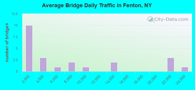
- 158,212Total average daily traffic
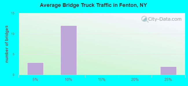
- 6,479Total average daily truck traffic
- National Bridge Inventory (NBI) Registered Bridges for Fenton
- No street view available for this location
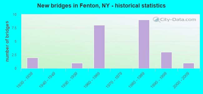
- New bridges - historical statistics
- 21930-1939
- 11950-1959
- 81960-1969
- 91980-1989
- 31990-1999
- 12000-2009
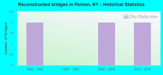
- Reconstructed bridges - Historical Statistics
- 21980-1989
- 01990-1999
- 22000-2009
- 22010-2019
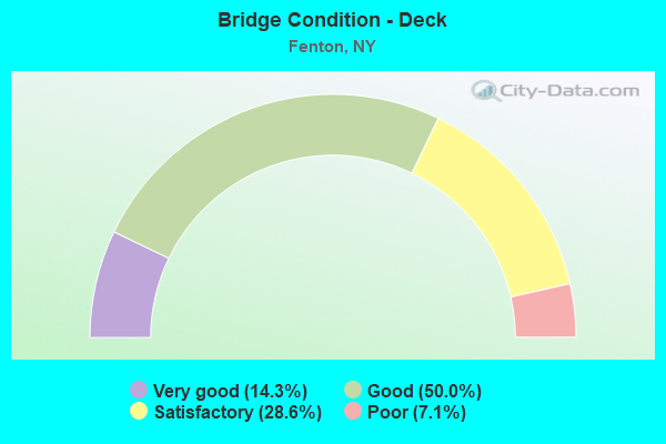
- Bridge Condition - Deck
- 14.3%Very good
- 50.0%Good
- 28.6%Satisfactory
- 7.1%Poor
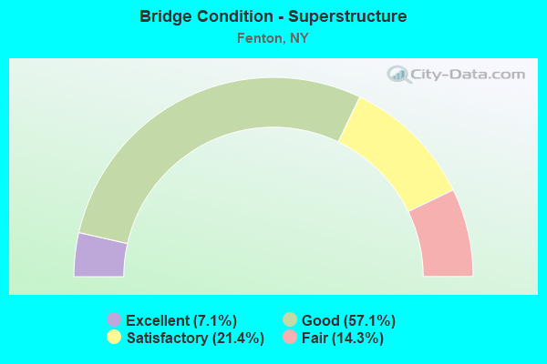
- Bridge Condition - Superstructure
- 7.1%Excellent
- 57.1%Good
- 21.4%Satisfactory
- 14.3%Fair
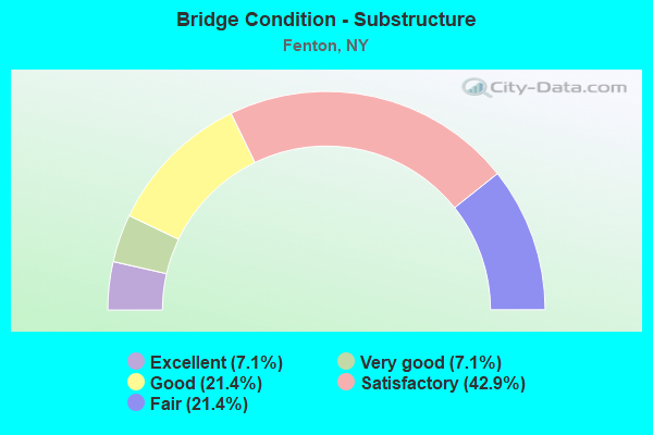
- Bridge Condition - Substructure
- 7.1%Excellent
- 7.1%Very good
- 21.4%Good
- 42.9%Satisfactory
- 21.4%Fair
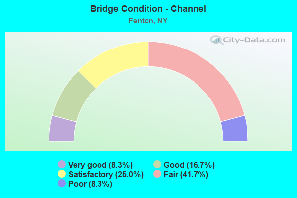
- Bridge Condition - Channel
- 8.3%Very good
- 16.7%Good
- 25.0%Satisfactory
- 41.7%Fair
- 8.3%Poor
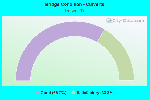
- Bridge Condition - Culverts
- 66.7%Good
- 33.3%Satisfactory
Find on map >> Show street view
Structure Number: 1003711, Location: JCT RTS 7 + 369 (Lat: 42.167214, Lng: -75.833222), Route carried "on" structure: Interstate 88, Year Built: 1968, Year Reconstructed: 2012, Status: Open, Structure Length: 5.24m (17.19ft), Average Daily Traffic: 12,345 (year 2009), Truck Traffic: 22%, Design Load: HS 20, Features Intersected: RTE 369
Minimum Vertical Clearance: 30+ m (98+ ft), Kilometerpoint: 7.466, Lanes on structure: 2, Lanes under structure: 2, Base Highway Network: Yes, Owner: State Highway Agency, Approaching Roadway Width: 11.9m (39.0ft), Skew: 3 degrees, Material/Design: Steel, Design/Construction: Stringer/Multi-beam, Number Of Spans In Main Unit: 3, Length of Maximum Span: 17.9m (58.7ft), Curb-To-Curb Width: 11.9m (39.0ft), Out-to-Out Width: 12.8m (42.0ft)
Condition: Deck: Good, Superstructure: Good, Substructure: Fair, Operating Rating: 45.4 metric tons, Method Used To Determine Operating Rating: Load and Resistance Factor Rating (LRFR) rating reported by rating factor(RF) method using HL-93 loadings, Inventory Rating: 35.0 metric tons, Method Used To Determine Inventory Rating: Load and Resistance Factor Rating (LRFR) rating reported by rating factor(RF) method using HL-93 loadings, Structural Evaluation: Somewhat better than minimum adequacy, Deck Geometry: Equal to present minimum criteria, Underclear: Meets minimum limits, Approach Roadway Alignment: Equal to present desirable criteria, Length Of Structure Improvement: 5.24m (17.19ft), Designated Inspection Frequency: Every 24 months, Inspection Date: October 2021, Bridge Improvement Cost: $1,641,000, Roadway Improvement Cost: $961,000, Total Project Cost: $2,602,000 ( Estimate for 2021), Deck Structure Type: Concrete Cast-file-Place, Wearing Surface/Protective System: Wearing Surface: Integral Concrete, Deck Protection: Epoxy Coated Reinforcing
Find on map >> Show street view
Structure Number: 1003712, Location: JCT RTS 7 + 369 (Lat: 42.167058, Lng: -75.833408), Route carried "on" structure: Interstate 88, Year Built: 1968, Year Reconstructed: 2012, Status: Open, Structure Length: 5.30m (17.39ft), Average Daily Traffic: 8,855 (year 2019), Truck Traffic: 21%, Average Future Daily Traffic: 11,647 (year 2040), Design Load: HS 20, Features Intersected: RTE 369
Minimum Vertical Clearance: 30+ m (98+ ft), Kilometerpoint: 7.466, Lanes on structure: 3, Lanes under structure: 2, Base Highway Network: Yes, Owner: State Highway Agency, Approaching Roadway Width: 14.9m (48.9ft), Skew: 3 degrees, Material/Design: Steel, Design/Construction: Stringer/Multi-beam, Number Of Spans In Main Unit: 3, Length of Maximum Span: 18.5m (60.7ft), Curb-To-Curb Width: 14.9m (48.9ft), Out-to-Out Width: 15.8m (51.8ft)
Condition: Deck: Very good, Superstructure: Good, Substructure: Satisfactory, Operating Rating: 69.9 metric tons, Method Used To Determine Operating Rating: Load Factor (LF), Inventory Rating: 41.7 metric tons, Method Used To Determine Inventory Rating: Load Factor (LF), Structural Evaluation: Equal to present minimum criteria, Deck Geometry: Meets minimum limits, Underclear: Meets minimum limits, Approach Roadway Alignment: Equal to present desirable criteria, Length Of Structure Improvement: 5.30m (17.39ft), Designated Inspection Frequency: Every 24 months, Inspection Date: October 2021, Bridge Improvement Cost: $2,026,000, Roadway Improvement Cost: $1,187,000, Total Project Cost: $3,213,000 ( Estimate for 2021), Deck Structure Type: Concrete Cast-file-Place, Wearing Surface/Protective System: Wearing Surface: Integral Concrete, Deck Protection: Epoxy Coated Reinforcing
Find on map >> Show street view
Structure Number: 103047, Location: .9 MI E JCT SH 79 & SH 36 (Lat: 42.249303, Lng: -75.779336), Route carried "on" structure: State highway 79, Year Built: 1992, Status: Open, Structure Length: 3.14m (10.30ft), Average Daily Traffic: 1,951 (year 2020), Truck Traffic: 7%, Average Future Daily Traffic: 2,035 (year 2040), Design Load: HS 20, Features Intersected: PAGE BROOK
Minimum Vertical Clearance: 30+ m (98+ ft), Kilometerpoint: 0.016, Lanes on structure: 2, Base Highway Network: Yes, Owner: State Highway Agency, Approaching Roadway Width: 8.5m (27.9ft), Skew: 3 degrees, Material/Design: Prestressed concrete, Design/Construction: Box Beam or Girders - Multiple, Number Of Spans In Main Unit: 1, Length of Maximum Span: 30.4m (99.7ft), Curb-To-Curb Width: 8.5m (27.9ft), Out-to-Out Width: 9.2m (30.2ft)
Condition: Deck: Satisfactory, Superstructure: Good, Substructure: Very good, Channel: Satisfactory, Inventory Rating: 73.5 metric tons, Method Used To Determine Inventory Rating: Load Factor (LF), Structural Evaluation: Better than present minimum criteria, Deck Geometry: Somewhat better than minimum adequacy, Waterway Adequacy: Equal to present desirable criteria, Approach Roadway Alignment: Equal to present desirable criteria, Length Of Structure Improvement: 3.13m (10.27ft), Designated Inspection Frequency: Every 24 months, Inspection Date: April 2020, Bridge Improvement Cost: $683,000, Roadway Improvement Cost: $400,000, Total Project Cost: $1,083,000 ( Estimate for 2021), Wearing Surface/Protective System: Wearing Surface: Monolithic Concrete
Find on map >> Show street view
Structure Number: 103048, Location: JCT SH 79 & CHENANGO RIVE (Lat: 42.244031, Lng: -75.837692), Route carried "on" structure: State highway 79, Year Built: 1936, Year Reconstructed: 2019, Status: Open, Structure Length: 12.10m (39.70ft), Average Daily Traffic: 983 (year 2016), Truck Traffic: 7%, Average Future Daily Traffic: 1,025 (year 2040), Design Load: HS 20, Features Intersected: CHENANGO RIVER
Minimum Vertical Clearance: 4.44m (14.57ft), Kilometerpoint: 5.197, Lanes on structure: 2, Base Highway Network: Yes, Owner: State Highway Agency, Approaching Roadway Width: 7.9m (25.9ft), Material/Design: Steel, Design/Construction: Truss - Thru, Number Of Spans In Main Unit: 2, Length of Maximum Span: 59.4m (194.9ft), Curb or Sidewalk Widths: Left: 1.6m (5.2ft), Right: 0.0m, Curb-To-Curb Width: 6.8m (22.3ft), Out-to-Out Width: 7.5m (24.6ft)
Condition: Deck: Poor, Superstructure: Fair, Substructure: Fair, Channel: Good, Operating Rating: 35.4 metric tons, Method Used To Determine Operating Rating: Load Factor (LF), Inventory Rating: 20.9 metric tons, Method Used To Determine Inventory Rating: Load Factor (LF), Structural Evaluation: Somewhat better than minimum adequacy, Deck Geometry: Meets minimum limits, Waterway Adequacy: Somewhat better than minimum adequacy, Approach Roadway Alignment: Equal to present minimum criteria, Length Of Structure Improvement: 12.10m (39.70ft), Designated Inspection Frequency: Every 24 months, Critical Feature Inspection Frequency: Every 24 months, Inspection Date: September 2020, Critical Feature Inspection Date: September 2020, Bridge Improvement Cost: $5,848,000, Roadway Improvement Cost: $3,424,000, Total Project Cost: $9,272,000 ( Estimate for 2021), Deck Structure Type: Open Grating, Wearing Surface/Protective System: Wearing Surface: Other
Find on map >> Show street view
Structure Number: 104682, Location: 0.5 MI NE JCT RTS 369 & 7 (Lat: 42.168531, Lng: -75.831778), Route carried "on" structure: State highway 369, Year Built: 1991, Status: Open, Structure Length: 3.51m (11.52ft), Average Daily Traffic: 5,598 (year 2016), Truck Traffic: 4%, Average Future Daily Traffic: 6,800 (year 2040), Design Load: HS 20, Features Intersected: OSBORNE CREEK
Minimum Vertical Clearance: 30+ m (98+ ft), Kilometerpoint: 0.949, Lanes on structure: 2, Base Highway Network: Yes, Owner: State Highway Agency, Approaching Roadway Width: 12.2m (40.0ft), Material/Design: Steel, Design/Construction: Stringer/Multi-beam, Number Of Spans In Main Unit: 1, Length of Maximum Span: 34.4m (112.9ft), Curb-To-Curb Width: 12.2m (40.0ft), Out-to-Out Width: 13.0m (42.7ft)
Condition: Deck: Good, Superstructure: Good, Substructure: Good, Channel: Fair, Operating Rating: 86.2 metric tons, Method Used To Determine Operating Rating: Load Factor (LF), Inventory Rating: 51.7 metric tons, Method Used To Determine Inventory Rating: Load Factor (LF), Structural Evaluation: Better than present minimum criteria, Deck Geometry: Somewhat better than minimum adequacy, Waterway Adequacy: Somewhat better than minimum adequacy, Approach Roadway Alignment: Equal to present desirable criteria, Length Of Structure Improvement: 3.50m (11.48ft), Designated Inspection Frequency: Every 24 months, Inspection Date: August 2021, Bridge Improvement Cost: $1,156,000, Roadway Improvement Cost: $677,000, Total Project Cost: $1,833,000 ( Estimate for 2021), Deck Structure Type: Concrete Cast-file-Place, Wearing Surface/Protective System: Wearing Surface: Integral Concrete, Deck Protection: Epoxy Coated Reinforcing
Find on map >> Show street view
Structure Number: 104683, Location: 0.2 MI S JCT RTS 369 + 79 (Lat: 42.240031, Lng: -75.795356), Route carried "on" structure: State highway 369, Year Built: 1961, Year Reconstructed: 2015, Status: Open, Structure Length: 3.47m (11.38ft), Average Daily Traffic: 2,260 (year 2017), Truck Traffic: 6%, Average Future Daily Traffic: 2,357 (year 2040), Design Load: HS 20, Features Intersected: PAGE BROOK
Minimum Vertical Clearance: 30+ m (98+ ft), Kilometerpoint: 9.815, Lanes on structure: 2, Base Highway Network: Yes, Owner: State Highway Agency, Approaching Roadway Width: 7.9m (25.9ft), Skew: 5 degrees, Material/Design: Steel, Design/Construction: Stringer/Multi-beam, Number Of Spans In Main Unit: 1, Length of Maximum Span: 33.5m (109.9ft), Curb-To-Curb Width: 9.6m (31.5ft), Out-to-Out Width: 10.6m (34.8ft)
Condition: Deck: Satisfactory, Superstructure: Fair, Substructure: Satisfactory, Channel: Satisfactory, Operating Rating: 41.7 metric tons, Method Used To Determine Operating Rating: Load Factor (LF), Inventory Rating: 24.5 metric tons, Method Used To Determine Inventory Rating: Load Factor (LF), Structural Evaluation: Somewhat better than minimum adequacy, Deck Geometry: Meets minimum limits, Waterway Adequacy: Meets minimum limits, Approach Roadway Alignment: Equal to present desirable criteria, Length Of Structure Improvement: 3.47m (11.38ft), Designated Inspection Frequency: Every 24 months, Inspection Date: June 2021, Bridge Improvement Cost: $1,564,000, Roadway Improvement Cost: $916,000, Total Project Cost: $2,480,000 ( Estimate for 2021), Deck Structure Type: Concrete Cast-file-Place, Wearing Surface/Protective System: Wearing Surface: Monolithic Concrete
Find on map >> Show street view
Structure Number: 105022, Location: 4 MI W JCT RTS 990J & 369 (Lat: 42.216433, Lng: -75.824892), Route carried "on" structure: State highway 990J, Year Built: 1991, Status: Open, Structure Length: 3.87m (12.70ft), Average Daily Traffic: 1,248 (year 2017), Truck Traffic: 2%, Average Future Daily Traffic: 1,747 (year 2037), Design Load: HS 20, Features Intersected: PAGE BROOK
Minimum Vertical Clearance: 30+ m (98+ ft), Kilometerpoint: 0.660, Lanes on structure: 2, Base Highway Network: Yes, Owner: State Highway Agency, Approaching Roadway Width: 10.4m (34.1ft), Skew: 4 degrees, Material/Design: Steel, Design/Construction: Stringer/Multi-beam, Number Of Spans In Main Unit: 1, Length of Maximum Span: 36.5m (119.8ft), Curb-To-Curb Width: 10.4m (34.1ft), Out-to-Out Width: 11.0m (36.1ft)
Condition: Deck: Good, Superstructure: Satisfactory, Substructure: Good, Channel: Fair, Operating Rating: 27.5 metric tons, Method Used To Determine Operating Rating: Load and Resistance Factor Rating (LRFR) rating reported by rating factor(RF) method using HL-93 loadings, Inventory Rating: 21.4 metric tons, Method Used To Determine Inventory Rating: Load and Resistance Factor Rating (LRFR) rating reported by rating factor(RF) method using HL-93 loadings, Structural Evaluation: Somewhat better than minimum adequacy, Deck Geometry: Equal to present minimum criteria, Waterway Adequacy: Meets minimum limits, Approach Roadway Alignment: Equal to present desirable criteria, Length Of Structure Improvement: 3.87m (12.70ft), Designated Inspection Frequency: Every 24 months, Inspection Date: June 2021, Bridge Improvement Cost: $1,239,000, Roadway Improvement Cost: $725,000, Total Project Cost: $1,964,000 ( Estimate for 2021), Deck Structure Type: Concrete Cast-file-Place, Wearing Surface/Protective System: Wearing Surface: Integral Concrete, Deck Protection: Epoxy Coated Reinforcing
Find on map >> Show street view
Structure Number: 107292, Location: .8 MI S JCT SH 369 & SH 7 (Lat: 42.232097, Lng: -75.797206), Route carried "on" structure: State highway 369, Year Built: 1961, Status: Open, Structure Length: 0.88m (2.89ft), Average Daily Traffic: 2,469 (year 2018), Truck Traffic: 5%, Average Future Daily Traffic: 2,575 (year 2040), Design Load: H 20, Features Intersected: TRIB PAGE BROOK
Minimum Vertical Clearance: 30+ m (98+ ft), Kilometerpoint: 8.914, Lanes on structure: 2, Base Highway Network: Yes, Owner: State Highway Agency, Approaching Roadway Width: 11.6m (38.1ft), Skew: 4 degrees, Material/Design: Steel, Design/Construction: Culvert, Number Of Spans In Main Unit: 2, Length of Maximum Span: 4.3m (14.1ft)
Condition: Channel: Poor, Culverts: Satisfactory, Operating Rating: 72.9 metric tons, Method Used To Determine Operating Rating: Field evaluation and documented engineering judgment, Inventory Rating: 32.7 metric tons, Method Used To Determine Inventory Rating: Field evaluation and documented engineering judgment, Structural Evaluation: Equal to present minimum criteria, Waterway Adequacy: Meets minimum limits, Approach Roadway Alignment: Equal to present minimum criteria, Length Of Structure Improvement: 0.88m (2.89ft), Designated Inspection Frequency: Every 24 months, Inspection Date: May 2020, Bridge Improvement Cost: $181,000, Roadway Improvement Cost: $106,000, Total Project Cost: $287,000 ( Estimate for 2021)
Find on map >> Show street view
Structure Number: 107375, Location: INTS. RT 12A & 88I (Lat: 42.164297, Lng: -75.873008), Route carried "on" structure: State highway 12A, Year Built: 1989, Status: Open, Structure Length: 3.69m (12.11ft), Average Daily Traffic: 12,363 (year 2020), Truck Traffic: 6%, Average Future Daily Traffic: 12,610 (year 2040), Design Load: HS 20, Features Intersected: 88I 88I91011257EB, RTE I
Minimum Vertical Clearance: 30+ m (98+ ft), Kilometerpoint: 1.561, Lanes on structure: 4, Lanes under structure: 4, Base Highway Network: Yes, Owner: State Highway Agency, Approaching Roadway Width: 17.7m (58.1ft), Skew: 2 degrees, Material/Design: Steel, Design/Construction: Stringer/Multi-beam, Number Of Spans In Main Unit: 1, Length of Maximum Span: 36.2m (118.8ft), Curb or Sidewalk Widths: Left: 2.4m (7.9ft), Right: 0.0m, Curb-To-Curb Width: 17.7m (58.1ft), Out-to-Out Width: 20.8m (68.2ft)
Condition: Deck: Good, Superstructure: Good, Substructure: Satisfactory, Operating Rating: 98.4 metric tons, Method Used To Determine Operating Rating: Field evaluation and documented engineering judgment, Inventory Rating: 32.7 metric tons, Method Used To Determine Inventory Rating: Field evaluation and documented engineering judgment, Structural Evaluation: Equal to present minimum criteria, Deck Geometry: Somewhat better than minimum adequacy, Underclear: Meets minimum limits, Approach Roadway Alignment: Equal to present desirable criteria, Length Of Structure Improvement: 3.68m (12.07ft), Designated Inspection Frequency: Every 24 months, Inspection Date: September 2021, Bridge Improvement Cost: $2,923,000, Roadway Improvement Cost: $1,711,000, Total Project Cost: $4,634,000 ( Estimate for 2021), Deck Structure Type: Concrete Cast-file-Place, Wearing Surface/Protective System: Wearing Surface: Integral Concrete, Deck Protection: Epoxy Coated Reinforcing
Find on map >> Show street view
Structure Number: 107376, Location: .5MI SW JCT RTE 12A & 88I (Lat: 42.160144, Lng: -75.881825), Route carried "on" structure: Other road , Year Built: 1989, Status: Open, Structure Length: 2.65m (8.69ft), Average Daily Traffic: 3,085 (year 2018), Truck Traffic: 6%, Average Future Daily Traffic: 3,817 (year 2040), Design Load: HS 20, Features Intersected: 88I 88I91011252WB, RTE I, Facility Carried by Structure: CHENANGO STREET
Minimum Vertical Clearance: 30+ m (98+ ft), Kilometerpoint: 0.016, Lanes on structure: 2, Lanes under structure: 4, Owner: State Highway Agency, Approaching Roadway Width: 15.8m (51.8ft), Material/Design: Steel, Design/Construction: Stringer/Multi-beam, Number Of Spans In Main Unit: 1, Length of Maximum Span: 25.2m (82.7ft), Curb or Sidewalk Widths: Left: 0.0m, Right: 2.4m (7.9ft), Curb-To-Curb Width: 11.0m (36.1ft), Out-to-Out Width: 14.1m (46.3ft)
Condition: Deck: Good, Superstructure: Good, Substructure: Good, Operating Rating: 90.6 metric tons, Method Used To Determine Operating Rating: Field evaluation and documented engineering judgment, Inventory Rating: 32.7 metric tons, Method Used To Determine Inventory Rating: Field evaluation and documented engineering judgment, Structural Evaluation: Better than present minimum criteria, Deck Geometry: Somewhat better than minimum adequacy, Underclear: High priority of corrective action, Approach Roadway Alignment: Equal to present desirable criteria, Length Of Structure Improvement: 2.65m (8.69ft), Designated Inspection Frequency: Every 24 months, Inspection Date: September 2021, Bridge Improvement Cost: $1,560,000, Roadway Improvement Cost: $914,000, Total Project Cost: $2,474,000 ( Estimate for 2021), Deck Structure Type: Concrete Cast-file-Place, Wearing Surface/Protective System: Wearing Surface: Integral Concrete, Deck Protection: Epoxy Coated Reinforcing
Find on map >> Show street view
Structure Number: 107377, Location: 1.1 MI SW JCT SH 12A & I8 (Lat: 42.152633, Lng: -75.888403), Route carried "on" structure: Other road , Year Built: 1989, Status: Open, Structure Length: 2.65m (8.69ft), Average Daily Traffic: 677 (year 2019), Truck Traffic: 5%, Average Future Daily Traffic: 837 (year 2040), Design Load: HS 20, Features Intersected: 88I 88I91011246WB, RTE I, Facility Carried by Structure: MIDDLE CROSSOVER
Minimum Vertical Clearance: 30+ m (98+ ft), Kilometerpoint: 0.016, Lanes on structure: 2, Lanes under structure: 4, Owner: State Highway Agency, Approaching Roadway Width: 8.5m (27.9ft), Material/Design: Steel, Design/Construction: Stringer/Multi-beam, Number Of Spans In Main Unit: 1, Length of Maximum Span: 25.2m (82.7ft), Curb-To-Curb Width: 8.5m (27.9ft), Out-to-Out Width: 9.5m (31.2ft)
Condition: Deck: Good, Superstructure: Satisfactory, Substructure: Satisfactory, Operating Rating: 90.6 metric tons, Method Used To Determine Operating Rating: Field evaluation and documented engineering judgment, Inventory Rating: 32.7 metric tons, Method Used To Determine Inventory Rating: Field evaluation and documented engineering judgment, Structural Evaluation: Equal to present minimum criteria, Deck Geometry: Somewhat better than minimum adequacy, Underclear: High priority of corrective action, Approach Roadway Alignment: Equal to present desirable criteria, Length Of Structure Improvement: 2.65m (8.69ft), Designated Inspection Frequency: Every 24 months, Inspection Date: April 2020, Bridge Improvement Cost: $1,003,000, Roadway Improvement Cost: $587,000, Total Project Cost: $1,591,000 ( Estimate for 2021), Deck Structure Type: Concrete Cast-file-Place, Wearing Surface/Protective System: Wearing Surface: Integral Concrete, Deck Protection: Epoxy Coated Reinforcing
Find on map >> Show street view
Structure Number: 222551, Location: 0.25 MILE WEST OF NYS 369 (Lat: 42.224964, Lng: -75.812783), Route carried "on" structure: Other road , Year Built: 1989, Status: Open, Structure Length: 2.19m (7.19ft), Average Daily Traffic: 427 (year 2017), Truck Traffic: 5%, Average Future Daily Traffic: 598 (year 2037), Design Load: H 20, Features Intersected: PAGE BROOK, Facility Carried by Structure: RICHARDS HILL RD
Minimum Vertical Clearance: 30+ m (98+ ft), Kilometerpoint: 0.644, Lanes on structure: 2, Owner: Town or Township Highway Agency, Approaching Roadway Width: 7.3m (24.0ft), Material/Design: Concrete continuous, Design/Construction: Culvert, Number Of Spans In Main Unit: 3, Length of Maximum Span: 7.3m (24.0ft), Curb-To-Curb Width: 7.6m (24.9ft), Out-to-Out Width: 8.2m (26.9ft)
Condition: Channel: Satisfactory, Culverts: Good, Operating Rating: 83.5 metric tons, Method Used To Determine Operating Rating: Load Factor (LF), Inventory Rating: 50.8 metric tons, Method Used To Determine Inventory Rating: Load Factor (LF), Structural Evaluation: Better than present minimum criteria, Deck Geometry: Meets minimum limits, Waterway Adequacy: Somewhat better than minimum adequacy, Approach Roadway Alignment: Meets minimum limits, Length Of Structure Improvement: 2.19m (7.19ft), Designated Inspection Frequency: Every 24 months, Inspection Date: March 2021, Bridge Improvement Cost: $611,000, Roadway Improvement Cost: $358,000, Total Project Cost: $968,000 ( Estimate for 2021)
Find on map >> Show street view
Structure Number: 334932, Location: 3 MI E OF CHENANGO BRIDG (Lat: 42.167847, Lng: -75.824297), Route carried "on" structure: County highway , Year Built: 1939, Year Reconstructed: 1991, Status: Open, Structure Length: 1.74m (5.71ft), Average Daily Traffic: 1,047 (year 2018), Truck Traffic: 5%, Average Future Daily Traffic: 1,466 (year 2038), Features Intersected: OSBORN CREEK, Facility Carried by Structure: BALLYHACK ROAD
Minimum Vertical Clearance: 30+ m (98+ ft), Kilometerpoint: 0.724, Lanes on structure: 2, Owner: County Highway Agency, Approaching Roadway Width: 6.7m (22.0ft), Skew: 1 degrees, Material/Design: Prestressed concrete, Design/Construction: Box Beam or Girders - Multiple, Number Of Spans In Main Unit: 1, Length of Maximum Span: 16.4m (53.8ft), Curb-To-Curb Width: 6.9m (22.6ft), Out-to-Out Width: 7.4m (24.3ft)
Condition: Deck: Good, Superstructure: Good, Substructure: Satisfactory, Channel: Fair, Operating Rating: 56.1 metric tons, Method Used To Determine Operating Rating: Field evaluation and documented engineering judgment, Inventory Rating: 22.6 metric tons, Method Used To Determine Inventory Rating: Field evaluation and documented engineering judgment, Structural Evaluation: Equal to present minimum criteria, Deck Geometry: High priority of corrective action, Waterway Adequacy: Equal to present minimum criteria, Approach Roadway Alignment: Better than present minimum criteria, Length Of Structure Improvement: 1.73m (5.68ft), Designated Inspection Frequency: Every 24 months, Inspection Date: March 2021, Bridge Improvement Cost: $387,000, Roadway Improvement Cost: $227,000, Total Project Cost: $614,000 ( Estimate for 2021), Wearing Surface/Protective System: Wearing Surface: Bituminous
Find on map >> Show street view
Structure Number: 334933, Location: 2.0 MI.NE.JCT.RT.7& 369 (Lat: 42.175653, Lng: -75.817047), Route carried "on" structure: County highway , Year Built: 1960, Status: Open, Structure Length: 1.22m (4.00ft), Average Daily Traffic: 1,047 (year 2018), Truck Traffic: 5%, Average Future Daily Traffic: 1,466 (year 2038), Design Load: HS 20, Features Intersected: BALLYHACK CREEK, Facility Carried by Structure: CR193 BALLYHACK R
Minimum Vertical Clearance: 30+ m (98+ ft), Kilometerpoint: 1.818, Lanes on structure: 2, Owner: County Highway Agency, Approaching Roadway Width: 8.8m (28.9ft), Skew: 4 degrees, Material/Design: Prestressed concrete, Design/Construction: Box Beam or Girders - Multiple, Number Of Spans In Main Unit: 1, Length of Maximum Span: 11.2m (36.7ft), Curb-To-Curb Width: 8.4m (27.6ft), Out-to-Out Width: 9.1m (29.9ft)
Condition: Deck: Satisfactory, Superstructure: Good, Substructure: Fair, Channel: Good, Operating Rating: 80.6 metric tons, Method Used To Determine Operating Rating: Field evaluation and documented engineering judgment, Inventory Rating: 32.7 metric tons, Method Used To Determine Inventory Rating: Field evaluation and documented engineering judgment, Structural Evaluation: Somewhat better than minimum adequacy, Deck Geometry: Meets minimum limits, Waterway Adequacy: Equal to present desirable criteria, Approach Roadway Alignment: Somewhat better than minimum adequacy, Length Of Structure Improvement: 1.21m (3.97ft), Designated Inspection Frequency: Every 24 months, Inspection Date: April 2020, Bridge Improvement Cost: $457,000, Roadway Improvement Cost: $268,000, Total Project Cost: $725,000 ( Estimate for 2021), Wearing Surface/Protective System: Wearing Surface: Bituminous
Find on map >> Show street view
Structure Number: 334934, Location: 2.2 MI NE JCT NY7 & NY369 (Lat: 42.181078, Lng: -75.812908), Route carried "on" structure: County highway , Year Built: 1957, Status: Open, Structure Length: 0.94m (3.08ft), Average Daily Traffic: 1,047 (year 2018), Truck Traffic: 5%, Average Future Daily Traffic: 1,466 (year 2038), Design Load: H 20, Features Intersected: BALLYHACK CREEK, Facility Carried by Structure: CR193 BALLYHACK R
Minimum Vertical Clearance: 30+ m (98+ ft), Kilometerpoint: 2.478, Lanes on structure: 2, Owner: County Highway Agency, Approaching Roadway Width: 9.1m (29.9ft), Skew: 3 degrees, Material/Design: Concrete, Design/Construction: Slab, Number Of Spans In Main Unit: 1, Length of Maximum Span: 8.8m (28.9ft), Curb-To-Curb Width: 7.9m (25.9ft), Out-to-Out Width: 8.7m (28.5ft)
Condition: Deck: Satisfactory, Superstructure: Satisfactory, Substructure: Satisfactory, Channel: Fair, Operating Rating: 54.4 metric tons, Method Used To Determine Operating Rating: Load Factor (LF), Inventory Rating: 32.7 metric tons, Method Used To Determine Inventory Rating: Load Factor (LF), Structural Evaluation: Equal to present minimum criteria, Deck Geometry: Meets minimum limits, Waterway Adequacy: Equal to present desirable criteria, Approach Roadway Alignment: Equal to present desirable criteria, Length Of Structure Improvement: 0.94m (3.08ft), Designated Inspection Frequency: Every 24 months, Inspection Date: April 2020, Bridge Improvement Cost: $301,000, Roadway Improvement Cost: $176,000, Total Project Cost: $478,000 ( Estimate for 2021), Deck Structure Type: Concrete Cast-file-Place, Wearing Surface/Protective System: Wearing Surface: Bituminous
Find on map >> Show street view
Structure Number: 334935, Location: 3.0 MI N JCT NY7 & NY369 (Lat: 42.197969, Lng: -75.825031), Route carried "on" structure: Other road , Year Built: 2007, Status: Open, Structure Length: 2.26m (7.41ft), Average Daily Traffic: 429 (year 2017), Truck Traffic: 2%, Average Future Daily Traffic: 601 (year 2037), Design Load: HS 25 or greater, Features Intersected: PAGE BROOK, Facility Carried by Structure: ROGERS ROAD
Minimum Vertical Clearance: 30+ m (98+ ft), Kilometerpoint: 0.257, Lanes on structure: 2, Owner: County Highway Agency, Approaching Roadway Width: 9.1m (29.9ft), Skew: 1 degrees, Material/Design: Prestressed concrete, Design/Construction: Box Beam or Girders - Multiple, Number Of Spans In Main Unit: 1, Length of Maximum Span: 22.3m (73.2ft), Curb-To-Curb Width: 9.1m (29.9ft), Out-to-Out Width: 10.1m (33.1ft)
Condition: Deck: Very good, Superstructure: Excellent, Substructure: Excellent, Channel: Very good, Inventory Rating: 81.6 metric tons, Method Used To Determine Inventory Rating: Load Factor (LF), Structural Evaluation: Superior to present desirable criteria, Deck Geometry: Equal to present minimum criteria, Waterway Adequacy: Equal to present desirable criteria, Approach Roadway Alignment: Equal to present desirable criteria, Length Of Structure Improvement: 2.25m (7.38ft), Designated Inspection Frequency: Every 24 months, Inspection Date: April 2020, Bridge Improvement Cost: $572,000, Roadway Improvement Cost: $335,000, Total Project Cost: $906,000 ( Estimate for 2021), Deck Structure Type: Concrete Cast-file-Place, Wearing Surface/Protective System: Wearing Surface: Integral Concrete, Deck Protection: Epoxy Coated Reinforcing
Find on map >> Show street view
Structure Number: 335009, Location: 0.7 MI NE OF PORT CRANE (Lat: 42.172681, Lng: -75.820678), Route carried "on" structure: County highway , Year Built: 1960, Year Reconstructed: 1993, Status: Open, Structure Length: 0.94m (3.08ft), Average Daily Traffic: 1,047 (year 2018), Truck Traffic: 5%, Average Future Daily Traffic: 1,466 (year 2038), Features Intersected: BALLYHACK CREEK, Facility Carried by Structure: CR 193
Minimum Vertical Clearance: 30+ m (98+ ft), Kilometerpoint: 1.352, Lanes on structure: 2, Owner: County Highway Agency, Approaching Roadway Width: 6.1m (20.0ft), Skew: 5 degrees, Material/Design: Steel, Design/Construction: Culvert, Number Of Spans In Main Unit: 1, Length of Maximum Span: 8.8m (28.9ft), Curb-To-Curb Width: 9.3m (30.5ft), Out-to-Out Width: 10.9m (35.8ft)
Condition: Channel: Fair, Culverts: Good, Operating Rating: 78.8 metric tons, Method Used To Determine Operating Rating: Field evaluation and documented engineering judgment, Inventory Rating: 32.7 metric tons, Method Used To Determine Inventory Rating: Field evaluation and documented engineering judgment, Structural Evaluation: Better than present minimum criteria, Deck Geometry: Somewhat better than minimum adequacy, Waterway Adequacy: Equal to present desirable criteria, Approach Roadway Alignment: Meets minimum limits, Length Of Structure Improvement: 0.94m (3.08ft), Designated Inspection Frequency: Every 24 months, Inspection Date: April 2020, Bridge Improvement Cost: $182,000, Roadway Improvement Cost: $107,000, Total Project Cost: $289,000 ( Estimate for 2021)
Find on map >> Show street view
Structure Number: 1003711, Location: JCT RTS 7 + 369 (Lat: 42.167214, Lng: -75.833222), Route carried "under" structure: State highway 369, Year Built: 1968, Structure Length: 0. m, Average Daily Traffic: 6,499 (year 2002), Features Intersected: RTE 369, Facility Carried by Structure: RTE I88
Minimum Vertical Clearance: 5.21m (17.09ft), Kilometerpoint: 0.901, Lanes on structure: 2, Lanes under structure: 2, Material/Design: Steel, Design/Construction: Stringer/Multi-beam, Length of Maximum Span: 17.9m (58.7ft)
Find on map >> Show street view
Structure Number: 1003712, Location: JCT RTS 7 + 369 (Lat: 42.167058, Lng: -75.833408), Route carried "under" structure: State highway 369, Year Built: 1968, Structure Length: 0. m, Average Daily Traffic: 6,499 (year 2002), Features Intersected: RTE 369, Facility Carried by Structure: RTE I88
Minimum Vertical Clearance: 4.52m (14.83ft), Kilometerpoint: 0.901, Lanes on structure: 3, Lanes under structure: 2, Material/Design: Steel, Design/Construction: Stringer/Multi-beam, Length of Maximum Span: 18.5m (60.7ft)
Find on map >> Show street view
Structure Number: 107375, Location: INTS. RT 12A & 88I (Lat: 42.164297, Lng: -75.873008), Route carried "under" structure: Interstate 88, Year Built: 1989, Structure Length: 0. m, Average Daily Traffic: 21,966 (year 1989), Features Intersected: 88I 88I91011257EB, RTE I, Facility Carried by Structure: RTE 12A
Minimum Vertical Clearance: 5.41m (17.75ft), Kilometerpoint: 3.218, Lanes on structure: 4, Lanes under structure: 2, Material/Design: Steel, Design/Construction: Stringer/Multi-beam, Length of Maximum Span: 36.2m (118.8ft)
Find on map >> Show street view
Structure Number: 107376, Location: .5MI SW JCT RTE 12A & 88I (Lat: 42.160144, Lng: -75.881825), Route carried "under" structure: Interstate 88, Year Built: 1989, Structure Length: 0. m, Average Daily Traffic: 21,966 (year 1989), Features Intersected: 88I 88I91011252WB, RTE I, Facility Carried by Structure: CHENANGO STREET
Minimum Vertical Clearance: 5.49m (18.01ft), Kilometerpoint: 2.414, Lanes on structure: 2, Lanes under structure: 2, Material/Design: Steel, Design/Construction: Stringer/Multi-beam, Length of Maximum Span: 25.2m (82.7ft)
Find on map >> Show street view
Structure Number: 107377, Location: 1.1 MI SW JCT SH 12A & I8 (Lat: 42.152633, Lng: -75.888403), Route carried "under" structure: Interstate 88, Year Built: 1989, Structure Length: 0. m, Average Daily Traffic: 21,966 (year 1989), Features Intersected: 88I 88I91011246WB, RTE I, Facility Carried by Structure: MIDDLE CROSSOVER
Minimum Vertical Clearance: 5.13m (16.83ft), Kilometerpoint: 1.931, Lanes on structure: 2, Lanes under structure: 2, Material/Design: Steel, Design/Construction: Stringer/Multi-beam, Length of Maximum Span: 25.2m (82.7ft)
Find on map >> Show street view
Structure Number: 70623, Location: .2 MI SW OF EXIT 2 - I88 (Lat: 42.163039, Lng: -75.876036), Route carried "under" structure: Interstate , Year Built: 1989, Structure Length: 0. m, Features Intersected: 88I 88I91011255, RTE I88, Facility Carried by Structure: NY SUSQ & W RR M.P
Minimum Vertical Clearance: 5.18m (16.99ft), Kilometerpoint: 4.682, Lanes under structure: 1, Material/Design: Steel, Design/Construction: Girder and Floorbeam System, Length of Maximum Span: 41.7m (136.8ft)
Find on map >> Show street view
Structure Number: 70623, Location: .2 MI SW OF EXIT 2 - I88 (Lat: 42.163039, Lng: -75.876036), Route carried "under" structure: Interstate 88, Year Built: 1989, Structure Length: 0. m, Average Daily Traffic: 22,438 (year 1990), Features Intersected: 88I 88I91011255, RTE I88, Facility Carried by Structure: NY SUSQ & W RR M.P
Minimum Vertical Clearance: 5.44m (17.85ft), Kilometerpoint: 4.682, Lanes under structure: 2, Material/Design: Steel, Design/Construction: Girder and Floorbeam System, Length of Maximum Span: 41.7m (136.8ft)