Bridge Statistics for Ferguson, Missouri (MO)
Condition, Traffic, Stress, Structural Evaluation, Project Costs
- National Bridge Inventory (NBI) Statistics
- 23Number of bridges
- 148ft / 45.1mTotal length
- $1,915,000Total costs
- 596,076Total average daily traffic
- 83,136Total average daily truck traffic
- National Bridge Inventory (NBI) Registered Bridges for Ferguson
- No street view available for this location
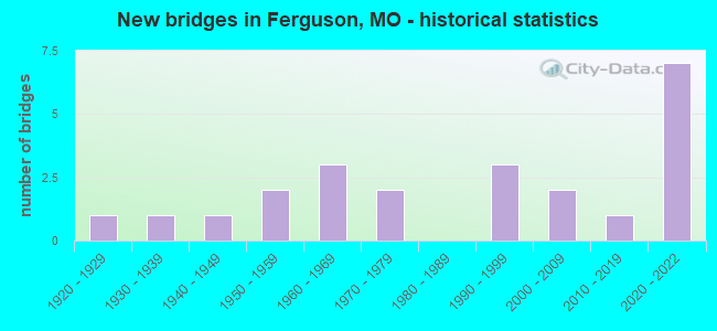
- New bridges - historical statistics
- 11920-1929
- 11930-1939
- 11940-1949
- 21950-1959
- 31960-1969
- 21970-1979
- 31990-1999
- 22000-2009
- 12010-2019
- 72020-2022
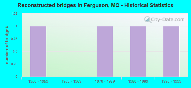
- Reconstructed bridges - Historical Statistics
- 11950-1959
- 01960-1969
- 11970-1979
- 11980-1989
- 11990-1999

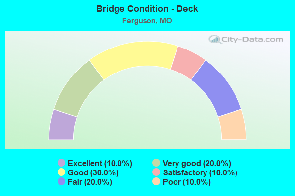
- Bridge Condition - Deck
- 10.0%Excellent
- 20.0%Very good
- 30.0%Good
- 10.0%Satisfactory
- 20.0%Fair
- 10.0%Poor
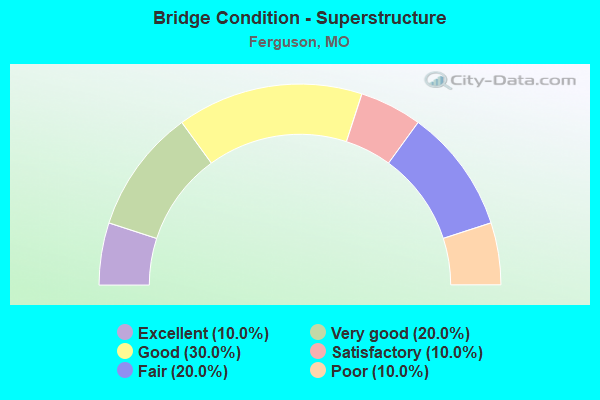
- Bridge Condition - Superstructure
- 10.0%Excellent
- 20.0%Very good
- 30.0%Good
- 10.0%Satisfactory
- 20.0%Fair
- 10.0%Poor
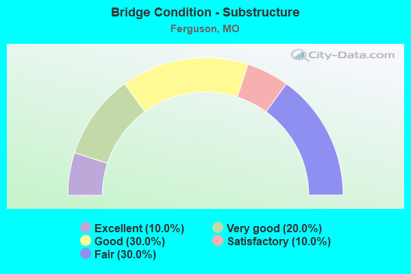
- Bridge Condition - Substructure
- 10.0%Excellent
- 20.0%Very good
- 30.0%Good
- 10.0%Satisfactory
- 30.0%Fair
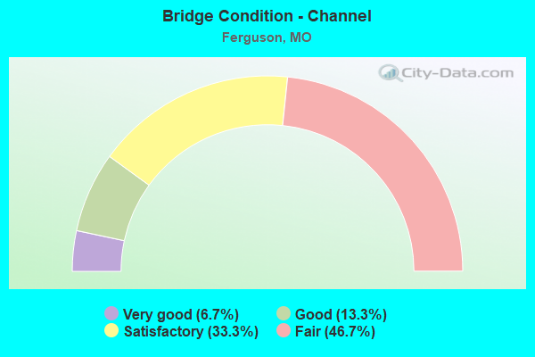
- Bridge Condition - Channel
- 6.7%Very good
- 13.3%Good
- 33.3%Satisfactory
- 46.7%Fair
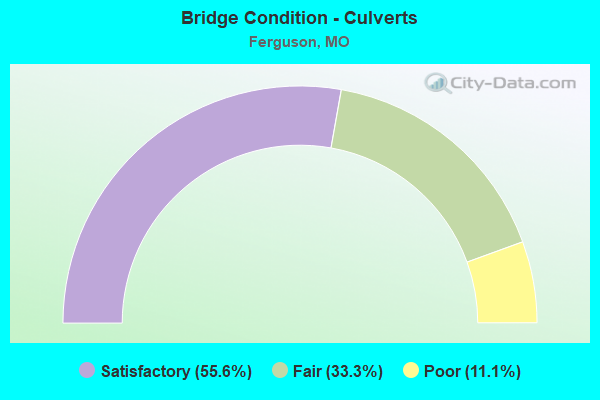
- Bridge Condition - Culverts
- 55.6%Satisfactory
- 33.3%Fair
- 11.1%Poor
Find on map >> Show street view
Structure Number: 11736, Location: S 2504 T 46 N R 6 E (Lat: 38.737411, Lng: -90.302261), Route carried "on" structure: State highway N, Year Built: 1997, Status: Open, Structure Length: 1.46m (4.79ft), Average Daily Traffic: 26,940 (year 2021), Truck Traffic: 5%, Average Future Daily Traffic: 37,716 (year 2041), Design Load: HS 20+Mod, Features Intersected: MALINE CR
Minimum Vertical Clearance: 30+ m (98+ ft), Kilometerpoint: 4.334, Lanes on structure: 4, Owner: State Highway Agency, Approaching Roadway Width: 16.5m (54.1ft), Skew: 2 degrees, Material/Design: Concrete continuous, Design/Construction: Culvert, Number Of Spans In Main Unit: 3, Length of Maximum Span: 4.3m (14.1ft)
Condition: Channel: Fair, Culverts: Satisfactory, Inventory Rating: 61.2 metric tons, Method Used To Determine Inventory Rating: Load Factor (LF), Structural Evaluation: Equal to present minimum criteria, Waterway Adequacy: Superior to present desirable criteria, Approach Roadway Alignment: Equal to present desirable criteria, Designated Inspection Frequency: Every 24 months, Inspection Date: November 2021
Find on map >> Show street view
Structure Number: 15529, Location: S 5 T 46 N R 7 E (Lat: 38.762722, Lng: -90.256453), Route carried "on" structure: County highway , Year Built: 1956, Status: Posted for load, Structure Length: 1.92m (6.30ft), Average Daily Traffic: 2,921 (year 2020), Truck Traffic: 3%, Average Future Daily Traffic: 3,943 (year 2040), Design Load: HS 20, Features Intersected: BLACK JACK CR, Facility Carried by Structure: VORHOF DR
Minimum Vertical Clearance: 30+ m (98+ ft), Kilometerpoint: 0.966, Lanes on structure: 2, Owner: County Highway Agency, Approaching Roadway Width: 7.6m (24.9ft), Material/Design: Steel, Design/Construction: Stringer/Multi-beam, Number Of Spans In Main Unit: 1, Length of Maximum Span: 18.0m (59.1ft), Curb or Sidewalk Widths: Left: 1.5m (4.9ft), Right: 1.5m (4.9ft), Curb-To-Curb Width: 7.9m (25.9ft), Out-to-Out Width: 11.0m (36.1ft)
Condition: Deck: Fair, Superstructure: Fair, Substructure: Fair, Channel: Satisfactory, Operating Rating: 35.1 metric tons, Method Used To Determine Operating Rating: Allowable Stress (AS), Inventory Rating: 22.5 metric tons, Method Used To Determine Inventory Rating: Allowable Stress (AS), Structural Evaluation: Somewhat better than minimum adequacy, Deck Geometry: High priority of corrective action, Waterway Adequacy: Better than present minimum criteria, Approach Roadway Alignment: Equal to present desirable criteria, Length Of Structure Improvement: 0.27m (0.89ft), Designated Inspection Frequency: Every 24 months, Inspection Date: March 2020, Bridge Improvement Cost: $232,000, Roadway Improvement Cost: $23,000, Total Project Cost: $349,000 ( Estimate for 2022), Deck Structure Type: Concrete Cast-file-Place, Wearing Surface/Protective System: Wearing Surface: Bituminous
Find on map >> Show street view
Structure Number: 15547, Location: S 12 T 46 N R 6 E (Lat: 38.738739, Lng: -90.296172), Route carried "on" structure: County highway , Year Built: 1961, Year Reconstructed: 1993, Status: Posted for load, Structure Length: 2.26m (7.41ft), Average Daily Traffic: 6,782 (year 2020), Truck Traffic: 5%, Average Future Daily Traffic: 9,156 (year 2040), Design Load: HS 20, Features Intersected: MALINE CR, Facility Carried by Structure: BERMUDA DR
Minimum Vertical Clearance: 30+ m (98+ ft), Kilometerpoint: 0.000, Lanes on structure: 2, Owner: County Highway Agency, Approaching Roadway Width: 9.8m (32.2ft), Skew: 2 degrees, Material/Design: Prestressed concrete, Design/Construction: Box Beam or Girders - Multiple, Number Of Spans In Main Unit: 2, Length of Maximum Span: 11.3m (37.1ft), Curb or Sidewalk Widths: Left: 1.2m (3.9ft), Right: 1.2m (3.9ft), Curb-To-Curb Width: 9.8m (32.2ft), Out-to-Out Width: 13.4m (44.0ft)
Condition: Deck: Satisfactory, Superstructure: Satisfactory, Substructure: Fair, Channel: Good, Operating Rating: 61.2 metric tons, Method Used To Determine Operating Rating: Allowable Stress (AS), Inventory Rating: 45.0 metric tons, Method Used To Determine Inventory Rating: Allowable Stress (AS), Structural Evaluation: Somewhat better than minimum adequacy, Deck Geometry: Meets minimum limits, Waterway Adequacy: Equal to present desirable criteria, Approach Roadway Alignment: Better than present minimum criteria, Designated Inspection Frequency: Every 24 months, Inspection Date: April 2020, Deck Structure Type: Other, Wearing Surface/Protective System: Wearing Surface: Bituminous, Membrane: Built-up
Find on map >> Show street view
Structure Number: 15665, Location: S 6 T 46 N R 7 E (Lat: 38.758869, Lng: -90.279719), Route carried "on" structure: County highway , Year Built: 1967, Status: Posted for load, Structure Length: 0.94m (3.08ft), Average Daily Traffic: 28,747 (year 2020), Truck Traffic: 10%, Average Future Daily Traffic: 38,808 (year 2040), Design Load: HS 20, Features Intersected: DELLWOOD CR, Facility Carried by Structure: W FLORISSANT AVE
Minimum Vertical Clearance: 30+ m (98+ ft), Kilometerpoint: 0.000, Lanes on structure: 4, Owner: County Highway Agency, Approaching Roadway Width: 18.3m (60.0ft), Material/Design: Concrete continuous, Design/Construction: Culvert, Number Of Spans In Main Unit: 2, Length of Maximum Span: 3.7m (12.1ft)
Condition: Channel: Fair, Culverts: Satisfactory, Operating Rating: 44.1 metric tons, Method Used To Determine Operating Rating: Allowable Stress (AS), Inventory Rating: 26.1 metric tons, Method Used To Determine Inventory Rating: Allowable Stress (AS), Structural Evaluation: Equal to present minimum criteria, Waterway Adequacy: Equal to present desirable criteria, Approach Roadway Alignment: Equal to present desirable criteria, Designated Inspection Frequency: Every 24 months, Inspection Date: March 2020
Find on map >> Show street view
Structure Number: 15668, Location: S 1 T 46 N R 6 E (Lat: 38.760514, Lng: -90.283214), Route carried "on" structure: County highway , Year Built: 1920, Status: Posted for load, Structure Length: 0.67m (2.20ft), Average Daily Traffic: 2,924 (year 2020), Truck Traffic: 1%, Average Future Daily Traffic: 3,947 (year 2040), Features Intersected: DELWOOD CR, Facility Carried by Structure: HUDSON DR
Minimum Vertical Clearance: 30+ m (98+ ft), Kilometerpoint: 6.276, Lanes on structure: 2, Owner: County Highway Agency, Approaching Roadway Width: 6.7m (22.0ft), Material/Design: Concrete, Design/Construction: Culvert, Number Of Spans In Main Unit: 1, Length of Maximum Span: 6.4m (21.0ft), Curb-To-Curb Width: 6.7m (22.0ft), Out-to-Out Width: 11.0m (36.1ft)
Condition: Channel: Satisfactory, Culverts: Satisfactory, Operating Rating: 35.1 metric tons, Method Used To Determine Operating Rating: Allowable Stress (AS), Inventory Rating: 22.5 metric tons, Method Used To Determine Inventory Rating: Allowable Stress (AS), Structural Evaluation: Equal to present minimum criteria, Deck Geometry: High priority of replacement, Waterway Adequacy: Equal to present desirable criteria, Approach Roadway Alignment: Equal to present desirable criteria, Length Of Structure Improvement: 0.13m (0.43ft), Designated Inspection Frequency: Every 24 months, Inspection Date: March 2020, Bridge Improvement Cost: $85,000, Roadway Improvement Cost: $9,000, Total Project Cost: $128,000 ( Estimate for 2022)
Find on map >> Show street view
Structure Number: 17112, Location: S 393 T 46 N R 7 E (Lat: 38.739075, Lng: -90.268375), Route carried "on" structure: City street , Year Built: 1999, Status: Open, Structure Length: 4.51m (14.80ft), Average Daily Traffic: 1,500 (year 2020), Truck Traffic: 1%, Average Future Daily Traffic: 2,025 (year 2040), Design Load: HS 20, Features Intersected: MALINE CR, Facility Carried by Structure: GLENOWEN DR
Minimum Vertical Clearance: 30+ m (98+ ft), Kilometerpoint: 0.322, Lanes on structure: 2, Owner: City or Municipal Highway Agency, Approaching Roadway Width: 9.1m (29.9ft), Material/Design: Prestressed concrete, Design/Construction: Stringer/Multi-beam, Number Of Spans In Main Unit: 3, Length of Maximum Span: 16.8m (55.1ft), Curb or Sidewalk Widths: Left: 1.5m (4.9ft), Right: 1.5m (4.9ft), Curb-To-Curb Width: 9.1m (29.9ft), Out-to-Out Width: 13.0m (42.7ft)
Condition: Deck: Good, Superstructure: Good, Substructure: Very good, Channel: Satisfactory, Operating Rating: 70.2 metric tons, Method Used To Determine Operating Rating: Load Factor (LF), Inventory Rating: 42.3 metric tons, Method Used To Determine Inventory Rating: Load Factor (LF), Structural Evaluation: Better than present minimum criteria, Deck Geometry: Somewhat better than minimum adequacy, Waterway Adequacy: Equal to present desirable criteria, Approach Roadway Alignment: Equal to present minimum criteria, Designated Inspection Frequency: Every 24 months, Inspection Date: December 2021, Deck Structure Type: Concrete Cast-file-Place, Wearing Surface/Protective System: Wearing Surface: Monolithic Concrete
Find on map >> Show street view
Structure Number: 17113, Location: S 2689 T 46 N R 6 E (Lat: 38.742014, Lng: -90.302369), Route carried "on" structure: City street , Year Built: 1975, Status: Posted for load, Structure Length: 0.67m (2.20ft), Average Daily Traffic: 4,000 (year 2020), Truck Traffic: 3%, Average Future Daily Traffic: 5,400 (year 2040), Features Intersected: TRIB OF MALINE CR, Facility Carried by Structure: ADAMS AVE
Minimum Vertical Clearance: 30+ m (98+ ft), Kilometerpoint: 0.483, Lanes on structure: 2, Owner: City or Municipal Highway Agency, Approaching Roadway Width: 7.6m (24.9ft), Material/Design: Concrete continuous, Design/Construction: Culvert, Number Of Spans In Main Unit: 2, Length of Maximum Span: 3.0m (9.8ft)
Condition: Channel: Satisfactory, Culverts: Fair, Operating Rating: 31.5 metric tons, Method Used To Determine Operating Rating: Field evaluation and documented engineering judgment, Inventory Rating: 20.7 metric tons, Method Used To Determine Inventory Rating: Field evaluation and documented engineering judgment, Structural Evaluation: Somewhat better than minimum adequacy, Waterway Adequacy: Better than present minimum criteria, Approach Roadway Alignment: Equal to present minimum criteria, Designated Inspection Frequency: Every 24 months, Inspection Date: December 2021
Find on map >> Show street view
Structure Number: 17115, Location: S 393 T 46 N R 6 E (Lat: 38.737294, Lng: -90.287972), Route carried "on" structure: City street , Year Built: 1977, Status: Posted for load, Structure Length: 3.51m (11.52ft), Average Daily Traffic: 5,973 (year 2020), Truck Traffic: 3%, Average Future Daily Traffic: 8,064 (year 2040), Design Load: HS 20, Features Intersected: MALINE CR, Facility Carried by Structure: FERGUSON AVE
Minimum Vertical Clearance: 30+ m (98+ ft), Kilometerpoint: 0.000, Lanes on structure: 3, Owner: City or Municipal Highway Agency, Approaching Roadway Width: 12.8m (42.0ft), Material/Design: Prestressed concrete continuous, Design/Construction: Stringer/Multi-beam, Number Of Spans In Main Unit: 3, Length of Maximum Span: 11.3m (37.1ft), Curb-To-Curb Width: 13.4m (44.0ft), Out-to-Out Width: 14.0m (45.9ft)
Condition: Deck: Poor, Superstructure: Poor, Substructure: Satisfactory, Channel: Satisfactory, Operating Rating: 31.5 metric tons, Method Used To Determine Operating Rating: Field evaluation and documented engineering judgment, Inventory Rating: 21.6 metric tons, Method Used To Determine Inventory Rating: Field evaluation and documented engineering judgment, Structural Evaluation: Meets minimum limits, Deck Geometry: Somewhat better than minimum adequacy, Waterway Adequacy: Equal to present minimum criteria, Approach Roadway Alignment: Equal to present desirable criteria, Bridge Posting: Required (Relationship of Operating Rating to Maximum Legal Load: 20.0 - 29.9% below), Length Of Structure Improvement: 0.44m (1.44ft), Designated Inspection Frequency: Every 24 months, Inspection Date: December 2021, Bridge Improvement Cost: $708,000, Roadway Improvement Cost: $71,000, Total Project Cost: $1,063,000 ( Estimate for 2022), Deck Structure Type: Concrete Cast-file-Place, Wearing Surface/Protective System: Wearing Surface: Bituminous
Find on map >> Show street view
Structure Number: 28622, Location: S 2 T 46 N R 6 E (Lat: 38.750992, Lng: -90.315097), Route carried "on" structure: City street , Year Built: 1955, Year Reconstructed: 2001, Status: Posted for load, Structure Length: 3.60m (11.81ft), Average Daily Traffic: 1,820 (year 2020), Truck Traffic: 10%, Average Future Daily Traffic: 2,457 (year 2040), Design Load: HS 20, Features Intersected: NS RR, Facility Carried by Structure: DADE AVE
Minimum Vertical Clearance: 30+ m (98+ ft), Kilometerpoint: 0.161, Lanes on structure: 2, Owner: City or Municipal Highway Agency, Approaching Roadway Width: 7.3m (24.0ft), Material/Design: Steel continuous, Design/Construction: Stringer/Multi-beam, Number Of Spans In Main Unit: 3, Length of Maximum Span: 13.4m (44.0ft), Curb-To-Curb Width: 7.3m (24.0ft), Out-to-Out Width: 11.2m (36.7ft)
Condition: Deck: Fair, Superstructure: Fair, Substructure: Fair, Operating Rating: 72.0 metric tons, Method Used To Determine Operating Rating: Load Factor (LF), Inventory Rating: 43.2 metric tons, Method Used To Determine Inventory Rating: Load Factor (LF), Structural Evaluation: Somewhat better than minimum adequacy, Deck Geometry: Meets minimum limits, Approach Roadway Alignment: Somewhat better than minimum adequacy, Designated Inspection Frequency: Every 24 months, Inspection Date: December 2021, Deck Structure Type: Concrete Cast-file-Place
Find on map >> Show street view
Structure Number: 28933, Location: S 2689 T 46 N R 6 E (Lat: 38.738969, Lng: -90.299764), Route carried "on" structure: City street , Year Built: 2002, Status: Open, Structure Length: 1.07m (3.51ft), Average Daily Traffic: 3,420 (year 2020), Truck Traffic: 5%, Average Future Daily Traffic: 4,617 (year 2040), Design Load: HS 20, Features Intersected: TRIB OF MALINE CR, Facility Carried by Structure: PAUL AVE
Minimum Vertical Clearance: 30+ m (98+ ft), Kilometerpoint: 0.000, Lanes on structure: 2, Owner: City or Municipal Highway Agency, Approaching Roadway Width: 8.8m (28.9ft), Material/Design: Steel, Design/Construction: Culvert, Number Of Spans In Main Unit: 1, Length of Maximum Span: 7.9m (25.9ft), Curb-To-Curb Width: 12.5m (41.0ft), Out-to-Out Width: 21.3m (69.9ft)
Condition: Channel: Fair, Culverts: Satisfactory, Operating Rating: 44.1 metric tons, Method Used To Determine Operating Rating: Load Factor (LF), Inventory Rating: 32.4 metric tons, Method Used To Determine Inventory Rating: Load Factor (LF), Structural Evaluation: Equal to present minimum criteria, Deck Geometry: Equal to present minimum criteria, Waterway Adequacy: Superior to present desirable criteria, Approach Roadway Alignment: Equal to present desirable criteria, Designated Inspection Frequency: Every 24 months, Inspection Date: December 2021
Find on map >> Show street view
Structure Number: 30698, Location: S 7 T 46 N R 7 E (Lat: 38.738697, Lng: -90.278394), Route carried "on" structure: County highway , Year Built: 2004, Status: Posted for load, Structure Length: 2.91m (9.55ft), Average Daily Traffic: 28,373 (year 2020), Truck Traffic: 10%, Average Future Daily Traffic: 38,304 (year 2040), Design Load: HS 25 or greater, Features Intersected: MALINE CR, Facility Carried by Structure: W FLORISSANT AVE
Minimum Vertical Clearance: 30+ m (98+ ft), Kilometerpoint: 0.000, Lanes on structure: 5, Owner: County Highway Agency, Approaching Roadway Width: 19.5m (64.0ft), Material/Design: Steel continuous, Design/Construction: Stringer/Multi-beam, Number Of Spans In Main Unit: 3, Length of Maximum Span: 10.1m (33.1ft), Curb-To-Curb Width: 19.5m (64.0ft), Out-to-Out Width: 23.8m (78.1ft)
Condition: Deck: Good, Superstructure: Good, Substructure: Good, Channel: Good, Operating Rating: 89.1 metric tons, Method Used To Determine Operating Rating: Load Factor (LF), Inventory Rating: 63.9 metric tons, Method Used To Determine Inventory Rating: Load Factor (LF), Structural Evaluation: Better than present minimum criteria, Deck Geometry: Meets minimum limits, Waterway Adequacy: Superior to present desirable criteria, Approach Roadway Alignment: Equal to present desirable criteria, Designated Inspection Frequency: Every 24 months, Inspection Date: April 2020, Deck Structure Type: Concrete Cast-file-Place, Wearing Surface/Protective System: Wearing Surface: Monolithic Concrete, Membrane: Other, Deck Protection: Epoxy Coated Reinforcing
Find on map >> Show street view
Structure Number: 35632, Location: S 32 T 47 N R 7 E (Lat: 38.765894, Lng: -90.259503), Route carried "on" structure: County highway , Year Built: 2018, Status: Not yet open, Structure Length: 1.52m (4.99ft), Average Daily Traffic: 10,330 (year 2020), Truck Traffic: 5%, Average Future Daily Traffic: 13,946 (year 2040), Features Intersected: HALLS FERRY CR, Facility Carried by Structure: OLD HALLS FERRY RD
Minimum Vertical Clearance: 30+ m (98+ ft), Kilometerpoint: 0.000, Lanes on structure: 2, Owner: County Highway Agency, Approaching Roadway Width: 10.8m (35.4ft), Skew: 3 degrees, Material/Design: Prestressed concrete, Design/Construction: Box Beam or Girders - Single/Spread, Number Of Spans In Main Unit: 1, Length of Maximum Span: 14.0m (45.9ft), Curb or Sidewalk Widths: Left: 0.0m, Right: 1.8m (5.9ft), Curb-To-Curb Width: 10.8m (35.4ft), Out-to-Out Width: 13.7m (44.9ft)
Condition: Deck: Very good, Superstructure: Very good, Substructure: Very good, Channel: Very good, Operating Rating: 97.2 metric tons, Method Used To Determine Operating Rating: Load Factor (LF), Inventory Rating: 69.3 metric tons, Method Used To Determine Inventory Rating: Load Factor (LF), Structural Evaluation: Equal to present desirable criteria, Deck Geometry: Meets minimum limits, Waterway Adequacy: Superior to present desirable criteria, Approach Roadway Alignment: Equal to present desirable criteria, Designated Inspection Frequency: Every 24 months, Inspection Date: March 2020, Deck Structure Type: Concrete Cast-file-Place, Wearing Surface/Protective System: Wearing Surface: Monolithic Concrete, Deck Protection: Epoxy Coated Reinforcing
Find on map >> Show street view
Structure Number: 36365, Location: S 31 T 47 N R 7 E (Lat: 38.770931, Lng: -90.260669), Route carried "on" structure: County highway , Year Built: 2020, Status: Open, Structure Length: 4.63m (15.19ft), Average Daily Traffic: 10,388 (year 2021), Truck Traffic: 5%, Average Future Daily Traffic: 14,543 (year 2041), Features Intersected: IS 270, IS 270, Facility Carried by Structure: OLD HALLS FERRY RD
Minimum Vertical Clearance: 30+ m (98+ ft), Kilometerpoint: 9.405, Lanes on structure: 6, Lanes under structure: 6, Owner: State Highway Agency, Approaching Roadway Width: 21.3m (69.9ft), Skew: 1 degrees, Material/Design: Prestressed concrete continuous, Design/Construction: Tee Beam, Number Of Spans In Main Unit: 2, Length of Maximum Span: 23.2m (76.1ft), Curb-To-Curb Width: 21.3m (69.9ft), Out-to-Out Width: 26.7m (87.6ft)
Condition: Deck: Very good, Superstructure: Very good, Substructure: Good, Operating Rating: 86.4 metric tons, Method Used To Determine Operating Rating: Load Factor (LF), Inventory Rating: 41.4 metric tons, Method Used To Determine Inventory Rating: Load Factor (LF), Structural Evaluation: Better than present minimum criteria, Deck Geometry: High priority of replacement, Approach Roadway Alignment: Equal to present desirable criteria, Designated Inspection Frequency: Every 24 months, Inspection Date: September 2020, Deck Structure Type: Concrete Cast-file-Place, Wearing Surface/Protective System: Wearing Surface: Monolithic Concrete, Deck Protection: Epoxy Coated Reinforcing
Find on map >> Show street view
Structure Number: 3637, Location: S 31 T 47 N R 7 E (Lat: 38.772739, Lng: -90.307731), Route carried "on" structure: City street , Year Built: 2020, Status: Open, Structure Length: 6.18m (20.28ft), Average Daily Traffic: 11,650 (year 2021), Truck Traffic: 5%, Average Future Daily Traffic: 16,310 (year 2041), Features Intersected: IS 270, Facility Carried by Structure: ELIZABETH AVE S
Minimum Vertical Clearance: 30+ m (98+ ft), Kilometerpoint: 0.000, Lanes on structure: 6, Lanes under structure: 8, Owner: State Highway Agency, Approaching Roadway Width: 21.3m (69.9ft), Skew: 4 degrees, Material/Design: Prestressed concrete continuous, Design/Construction: Tee Beam, Number Of Spans In Main Unit: 2, Length of Maximum Span: 30.2m (99.1ft), Curb or Sidewalk Widths: Left: 2.7m (8.9ft), Right: 1.8m (5.9ft), Curb-To-Curb Width: 21.3m (69.9ft), Out-to-Out Width: 26.7m (87.6ft)
Condition: Deck: Excellent, Superstructure: Excellent, Substructure: Excellent, Operating Rating: 83.7 metric tons, Method Used To Determine Operating Rating: Load Factor (LF), Inventory Rating: 45.9 metric tons, Method Used To Determine Inventory Rating: Load Factor (LF), Structural Evaluation: Superior to present desirable criteria, Deck Geometry: High priority of replacement, Underclear: High priority of corrective action, Approach Roadway Alignment: Equal to present desirable criteria, Designated Inspection Frequency: Every 24 months, Inspection Date: November 2020, Deck Structure Type: Concrete Cast-file-Place, Wearing Surface/Protective System: Wearing Surface: Monolithic Concrete, Deck Protection: Epoxy Coated Reinforcing
Find on map >> Show street view
Structure Number: 36371, Location: S 31 T 47 N R 7 E (Lat: 38.772781, Lng: -90.308111), Route carried "on" structure: Ramp State highway , Year Built: 2020, Status: Open, Structure Length: 4.88m (16.01ft), Average Daily Traffic: 2,000 (year 2021), Truck Traffic: 10%, Average Future Daily Traffic: 3,000 (year 2041), Features Intersected: IS 270, Facility Carried by Structure: CO IS270E TO ELIZA
Minimum Vertical Clearance: 30+ m (98+ ft), Kilometerpoint: 0.134, Lanes on structure: 1, Lanes under structure: 8, Owner: State Highway Agency, Approaching Roadway Width: 16.0m (52.5ft), Skew: 2 degrees, Material/Design: Prestressed concrete continuous, Design/Construction: Tee Beam, Number Of Spans In Main Unit: 2, Length of Maximum Span: 23.9m (78.4ft), Curb-To-Curb Width: 16.0m (52.5ft), Out-to-Out Width: 16.8m (55.1ft)
Condition: Deck: Good, Superstructure: Good, Substructure: Good, Operating Rating: 94.5 metric tons, Method Used To Determine Operating Rating: Load Factor (LF), Inventory Rating: 48.6 metric tons, Method Used To Determine Inventory Rating: Load Factor (LF), Structural Evaluation: Better than present minimum criteria, Deck Geometry: Superior to present desirable criteria, Underclear: High priority of corrective action, Approach Roadway Alignment: Equal to present minimum criteria, Designated Inspection Frequency: Every 24 months, Inspection Date: January 2022, Deck Structure Type: Concrete Cast-file-Place, Wearing Surface/Protective System: Wearing Surface: Monolithic Concrete, Deck Protection: Epoxy Coated Reinforcing
Find on map >> Show street view
Structure Number: 36518, Location: S 2504 T 46 N R 6 W (Lat: 38.737411, Lng: -90.302261), Route carried "on" structure: City street , Year Built: 1997, Status: Open, Structure Length: 1.46m (4.79ft), Average Daily Traffic: 26,955 (year 2019), Truck Traffic: 5%, Average Future Daily Traffic: 36,389 (year 2039), Design Load: HS 20+Mod, Features Intersected: MALINE CR, Facility Carried by Structure: FLORISSANT RD
Minimum Vertical Clearance: 30+ m (98+ ft), Kilometerpoint: 4.334, Lanes on structure: 4, Owner: City or Municipal Highway Agency, Approaching Roadway Width: 16.5m (54.1ft), Skew: 2 degrees, Material/Design: Concrete continuous, Design/Construction: Culvert, Number Of Spans In Main Unit: 3, Length of Maximum Span: 4.3m (14.1ft)
Condition: Channel: Fair, Culverts: Satisfactory, Inventory Rating: 61.2 metric tons, Method Used To Determine Inventory Rating: Load Factor (LF), Structural Evaluation: Equal to present minimum criteria, Waterway Adequacy: Superior to present desirable criteria, Approach Roadway Alignment: Equal to present desirable criteria, Designated Inspection Frequency: Every 24 months, Inspection Date: December 2021
Find on map >> Show street view
Structure Number: 5568, Location: S 31 T 47 N R 7 E (Lat: 38.770958, Lng: -90.267817), Route carried "on" structure: Interstate 270, Year Built: 1931, Year Reconstructed: 1961, Status: Open, Structure Length: 0.76m (2.49ft), Average Daily Traffic: 121,822 (year 2021), Truck Traffic: 18%, Average Future Daily Traffic: 152,278 (year 2041), Design Load: HS 20, Features Intersected: MALINE CR
Minimum Vertical Clearance: 30+ m (98+ ft), Kilometerpoint: 49.129, Lanes on structure: 8, Base Highway Network: Yes, Owner: State Highway Agency, Approaching Roadway Width: 40.2m (131.9ft), Skew: 23 degrees, Material/Design: Concrete continuous, Design/Construction: Culvert, Number Of Spans In Main Unit: 2, Length of Maximum Span: 3.0m (9.8ft)
Condition: Channel: Fair, Culverts: Poor, Operating Rating: 71.1 metric tons, Method Used To Determine Operating Rating: Load Factor (LF), Inventory Rating: 42.3 metric tons, Method Used To Determine Inventory Rating: Load Factor (LF), Structural Evaluation: Meets minimum limits, Waterway Adequacy: Equal to present minimum criteria, Approach Roadway Alignment: Equal to present desirable criteria, Length Of Structure Improvement: 0.14m (0.46ft), Designated Inspection Frequency: Every 12 months, Inspection Date: November 2021, Bridge Improvement Cost: $250,000, Roadway Improvement Cost: $25,000, Total Project Cost: $375,000 ( Estimate for 2022)
Find on map >> Show street view
Structure Number: 6164, Location: S 14 T 46 N R 6 E (Lat: 38.729033, Lng: -90.301894), Route carried "on" structure: State highway N, Year Built: 1949, Year Reconstructed: 1978, Status: Open, Structure Length: 0.90m (2.95ft), Average Daily Traffic: 17,240 (year 2021), Truck Traffic: 5%, Average Future Daily Traffic: 24,136 (year 2041), Design Load: HS 20, Features Intersected: BALL CR
Minimum Vertical Clearance: 30+ m (98+ ft), Kilometerpoint: 5.272, Lanes on structure: 5, Owner: State Highway Agency, Approaching Roadway Width: 9.8m (32.2ft), Skew: 5 degrees, Material/Design: Concrete continuous, Design/Construction: Culvert, Number Of Spans In Main Unit: 2, Length of Maximum Span: 2.7m (8.9ft)
Condition: Channel: Fair, Culverts: Fair, Operating Rating: 52.2 metric tons, Method Used To Determine Operating Rating: Load Factor (LF), Inventory Rating: 31.5 metric tons, Method Used To Determine Inventory Rating: Load Factor (LF), Structural Evaluation: Somewhat better than minimum adequacy, Waterway Adequacy: Equal to present desirable criteria, Approach Roadway Alignment: Equal to present desirable criteria, Designated Inspection Frequency: Every 24 months, Inspection Date: November 2021
Find on map >> Show street view
Structure Number: 903, Location: S 31 T 47 N R 7 E (Lat: 38.769622, Lng: -90.265356), Route carried "on" structure: State highway AC, Year Built: 1968, Status: Open, Structure Length: 1.28m (4.20ft), Average Daily Traffic: 13,900 (year 2021), Truck Traffic: 5%, Average Future Daily Traffic: 19,460 (year 2041), Design Load: HS 20, Features Intersected: BR MALINE CR
Minimum Vertical Clearance: 30+ m (98+ ft), Kilometerpoint: 5.351, Lanes on structure: 4, Base Highway Network: Yes, Owner: State Highway Agency, Approaching Roadway Width: 21.9m (71.9ft), Skew: 26 degrees, Material/Design: Concrete continuous, Design/Construction: Culvert, Number Of Spans In Main Unit: 2, Length of Maximum Span: 3.0m (9.8ft)
Condition: Channel: Fair, Culverts: Fair, Operating Rating: 47.7 metric tons, Method Used To Determine Operating Rating: Load Factor (LF), Inventory Rating: 28.8 metric tons, Method Used To Determine Inventory Rating: Load Factor (LF), Structural Evaluation: Somewhat better than minimum adequacy, Waterway Adequacy: Equal to present minimum criteria, Approach Roadway Alignment: Equal to present desirable criteria, Designated Inspection Frequency: Every 24 months, Inspection Date: November 2021
Find on map >> Show street view
Structure Number: 3637, Location: S 31 T 47 N R 7 E (Lat: 38.772739, Lng: -90.307731), Route carried "under" structure: Interstate 270, Year Built: 2020, Structure Length: 0. m, Average Daily Traffic: 67,949 (year 2021), Truck Traffic: 18%, Features Intersected: IS 270, Facility Carried by Structure: ELIZABETH AVE S
Minimum Vertical Clearance: 5.03m (16.50ft), Kilometerpoint: 11.908, Lanes on structure: 6, Lanes under structure: 4, Material/Design: Prestressed concrete continuous, Design/Construction: Tee Beam, Length of Maximum Span: 30.2m (99.1ft)
Find on map >> Show street view
Structure Number: 3637, Location: S 31 T 47 N R 7 E (Lat: 38.772739, Lng: -90.307731), Route carried "under" structure: Interstate 270, Year Built: 2020, Structure Length: 0. m, Average Daily Traffic: 66,681 (year 2021), Truck Traffic: 18%, Features Intersected: IS 270, Facility Carried by Structure: ELIZABETH AVE S
Minimum Vertical Clearance: 5.03m (16.50ft), Kilometerpoint: 45.662, Lanes on structure: 6, Lanes under structure: 4, Material/Design: Prestressed concrete continuous, Design/Construction: Tee Beam, Length of Maximum Span: 30.2m (99.1ft)
Find on map >> Show street view
Structure Number: 36371, Location: S 31 T 47 N R 7 E (Lat: 38.772781, Lng: -90.308111), Route carried "under" structure: Interstate 270, Year Built: 2020, Structure Length: 0. m, Average Daily Traffic: 66,681 (year 2021), Truck Traffic: 18%, Features Intersected: IS 270
Minimum Vertical Clearance: 5.03m (16.50ft), Kilometerpoint: 45.622, Lanes on structure: 1, Lanes under structure: 4, Material/Design: Prestressed concrete continuous, Design/Construction: Tee Beam, Length of Maximum Span: 23.9m (78.4ft)
Find on map >> Show street view
Structure Number: 36371, Location: S 31 T 47 N R 7 E (Lat: 38.772781, Lng: -90.308111), Route carried "under" structure: Interstate 270, Year Built: 2020, Structure Length: 0. m, Average Daily Traffic: 67,080 (year 2021), Truck Traffic: 18%, Features Intersected: IS 270
Minimum Vertical Clearance: 5.03m (16.50ft), Kilometerpoint: 11.938, Lanes on structure: 1, Lanes under structure: 4, Material/Design: Prestressed concrete continuous, Design/Construction: Tee Beam, Length of Maximum Span: 23.9m (78.4ft)