Bridge Statistics for Fieldale, Virginia (VA)
Condition, Traffic, Stress, Structural Evaluation, Project Costs
- National Bridge Inventory (NBI) Statistics
- 11Number of bridges
- 135ft / 40.8mTotal length
- $24,854,000Total costs
- 51,638Total average daily traffic
- 5,232Total average daily truck traffic
- National Bridge Inventory (NBI) Registered Bridges for Fieldale
- No street view available for this location
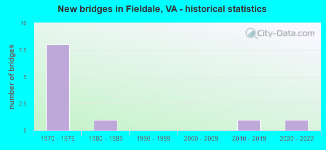
- New bridges - historical statistics
- 81970-1979
- 11980-1989
- 12010-2019
- 12020-2022


- Bridge Condition - Deck
- 28.6%Good
- 71.4%Satisfactory

- Bridge Condition - Superstructure
- 71.4%Good
- 14.3%Satisfactory
- 14.3%Fair

- Bridge Condition - Substructure
- 28.6%Good
- 57.1%Satisfactory
- 14.3%Fair

- Bridge Condition - Channel
- 57.1%Good
- 42.9%Satisfactory
Find on map >> Show street view
Structure Number: 10079, Location: 4.87-RT 57&220;2.91-RT 58 (Lat: 36.684111, Lng: -79.939278), Route carried "on" structure: Bypass US 220, Year Built: 1976, Status: Open, Structure Length: 8.75m (28.71ft), Average Daily Traffic: 6,758 (year 2020), Truck Traffic: 16%, Average Future Daily Traffic: 9,461 (year 2040), Design Load: HS 20+Mod, Features Intersected: QUARRY RD; 684 & JORDAN
Minimum Vertical Clearance: 30+ m (98+ ft), Kilometerpoint: 21.459, Lanes on structure: 2, Lanes under structure: 2, Base Highway Network: Yes, Owner: State Highway Agency, Approaching Roadway Width: 9.8m (32.2ft), Skew: 2 degrees, Material/Design: Steel continuous, Design/Construction: Stringer/Multi-beam, Number Of Spans In Main Unit: 3, Number Of Approach Spans: 2, Length of Maximum Span: 22.9m (75.1ft), Curb-To-Curb Width: 11.6m (38.1ft), Out-to-Out Width: 12.8m (42.0ft)
Condition: Deck: Good, Superstructure: Good, Substructure: Satisfactory, Channel: Good, Operating Rating: 67.1 metric tons, Method Used To Determine Operating Rating: Load and Resistance Factor (LRFR), Inventory Rating: 51.7 metric tons, Method Used To Determine Inventory Rating: Load and Resistance Factor (LRFR), Structural Evaluation: Equal to present minimum criteria, Deck Geometry: Equal to present minimum criteria, Underclear: Better than present minimum criteria, Waterway Adequacy: Equal to present desirable criteria, Approach Roadway Alignment: Equal to present desirable criteria, Designated Inspection Frequency: Every 24 months, Inspection Date: April 2020, Deck Structure Type: Concrete Cast-file-Place, Wearing Surface/Protective System: Wearing Surface: Latex Concrete
Find on map >> Show street view
Structure Number: 10081, Location: 4.87-RT57&220;2.91-RT 58 (Lat: 36.684311, Lng: -79.939136), Route carried "on" structure: Bypass US 220, Year Built: 1976, Status: Open, Structure Length: 8.75m (28.71ft), Average Daily Traffic: 6,758 (year 2020), Truck Traffic: 16%, Average Future Daily Traffic: 9,461 (year 2040), Design Load: HS 20+Mod, Features Intersected: JORDAN CK; 684 & QUAR RD
Minimum Vertical Clearance: 30+ m (98+ ft), Kilometerpoint: 21.459, Lanes on structure: 2, Lanes under structure: 2, Base Highway Network: Yes, Owner: State Highway Agency, Approaching Roadway Width: 9.8m (32.2ft), Skew: 2 degrees, Material/Design: Steel continuous, Design/Construction: Stringer/Multi-beam, Number Of Spans In Main Unit: 3, Number Of Approach Spans: 2, Length of Maximum Span: 22.9m (75.1ft), Curb-To-Curb Width: 11.6m (38.1ft), Out-to-Out Width: 12.8m (42.0ft)
Condition: Deck: Satisfactory, Superstructure: Good, Substructure: Satisfactory, Channel: Good, Operating Rating: 67.1 metric tons, Method Used To Determine Operating Rating: Load and Resistance Factor (LRFR), Inventory Rating: 51.7 metric tons, Method Used To Determine Inventory Rating: Load and Resistance Factor (LRFR), Structural Evaluation: Equal to present minimum criteria, Deck Geometry: Equal to present minimum criteria, Underclear: Equal to present minimum criteria, Waterway Adequacy: Equal to present desirable criteria, Approach Roadway Alignment: Equal to present desirable criteria, Designated Inspection Frequency: Every 24 months, Inspection Date: April 2020, Deck Structure Type: Concrete Cast-file-Place, Wearing Surface/Protective System: Wearing Surface: Latex Concrete
Find on map >> Show street view
Structure Number: 10102, Location: 0.03 Rt 682; 0.11 Rt 57 (Lat: 36.704786, Lng: -79.934978), Route carried "on" structure: County highway 609, Year Built: 1970, Status: Open, Structure Length: 5.19m (17.03ft), Average Daily Traffic: 2,206 (year 2020), Truck Traffic: 5%, Average Future Daily Traffic: 2,223 (year 2040), Design Load: HS 20+Mod, Features Intersected: Smith River
Minimum Vertical Clearance: 30+ m (98+ ft), Kilometerpoint: 7.739, Lanes on structure: 2, Owner: State Highway Agency, Approaching Roadway Width: 7.9m (25.9ft), Material/Design: Steel, Design/Construction: Stringer/Multi-beam, Number Of Spans In Main Unit: 3, Length of Maximum Span: 17.0m (55.8ft), Curb-To-Curb Width: 9.8m (32.2ft), Out-to-Out Width: 10.6m (34.8ft)
Condition: Deck: Satisfactory, Superstructure: Fair, Substructure: Fair, Channel: Satisfactory, Operating Rating: 63.5 metric tons, Method Used To Determine Operating Rating: Load and Resistance Factor (LRFR), Inventory Rating: 49.0 metric tons, Method Used To Determine Inventory Rating: Load and Resistance Factor (LRFR), Structural Evaluation: Somewhat better than minimum adequacy, Deck Geometry: Meets minimum limits, Waterway Adequacy: Meets minimum limits, Approach Roadway Alignment: Equal to present desirable criteria, Designated Inspection Frequency: Every 24 months, Inspection Date: May 2020, Deck Structure Type: Concrete Cast-file-Place
Find on map >> Show street view
Structure Number: 10108, Location: 0.55 RT 683; 0.40 RT 812 (Lat: 36.695328, Lng: -79.953697), Route carried "on" structure: County highway 609, Year Built: 1976, Status: Open, Structure Length: 6.10m (20.01ft), Average Daily Traffic: 5,421 (year 2020), Truck Traffic: 3%, Average Future Daily Traffic: 7,589 (year 2040), Design Load: HS 20+Mod, Features Intersected: RTE 220
Minimum Vertical Clearance: 30+ m (98+ ft), Kilometerpoint: 5.020, Lanes on structure: 2, Lanes under structure: 4, Owner: State Highway Agency, Approaching Roadway Width: 8.5m (27.9ft), Skew: 2 degrees, Material/Design: Steel continuous, Design/Construction: Stringer/Multi-beam, Number Of Spans In Main Unit: 2, Length of Maximum Span: 30.5m (100.1ft), Curb-To-Curb Width: 10.4m (34.1ft), Out-to-Out Width: 11.6m (38.1ft)
Condition: Deck: Satisfactory, Superstructure: Good, Substructure: Satisfactory, Operating Rating: 89.8 metric tons, Method Used To Determine Operating Rating: Load and Resistance Factor (LRFR), Inventory Rating: 57.2 metric tons, Method Used To Determine Inventory Rating: Load and Resistance Factor (LRFR), Structural Evaluation: Equal to present minimum criteria, Deck Geometry: Meets minimum limits, Underclear: Equal to present minimum criteria, Approach Roadway Alignment: Equal to present desirable criteria, Designated Inspection Frequency: Every 24 months, Inspection Date: January 2020, Deck Structure Type: Concrete Cast-file-Place, Wearing Surface/Protective System: Wearing Surface: Epoxy Overlay
Find on map >> Show street view
Structure Number: 10153, Location: 0.11-Rte609; 0.39-Rte837 (Lat: 36.694333, Lng: -79.963372), Route carried "on" structure: County highway 683, Year Built: 1988, Status: Open, Structure Length: 1.95m (6.40ft), Average Daily Traffic: 1,657 (year 2020), Truck Traffic: 2%, Average Future Daily Traffic: 2,320 (year 2040), Features Intersected: Rangeley Creek
Minimum Vertical Clearance: 30+ m (98+ ft), Kilometerpoint: 6.706, Lanes on structure: 2, Owner: State Highway Agency, Approaching Roadway Width: 6.7m (22.0ft), Skew: 4 degrees, Material/Design: Concrete, Design/Construction: Slab, Number Of Spans In Main Unit: 2, Length of Maximum Span: 9.8m (32.2ft), Curb-To-Curb Width: 7.9m (25.9ft), Out-to-Out Width: 9.1m (29.9ft)
Condition: Deck: Satisfactory, Superstructure: Satisfactory, Substructure: Satisfactory, Channel: Satisfactory, Operating Rating: 81.6 metric tons, Method Used To Determine Operating Rating: Load and Resistance Factor (LRFR), Inventory Rating: 62.6 metric tons, Method Used To Determine Inventory Rating: Load and Resistance Factor (LRFR), Structural Evaluation: Equal to present minimum criteria, Deck Geometry: Meets minimum limits, Waterway Adequacy: Meets minimum limits, Approach Roadway Alignment: Equal to present minimum criteria, Length Of Structure Improvement: 1.95m (6.40ft), Designated Inspection Frequency: Every 24 months, Inspection Date: January 2022, Bridge Improvement Cost: $1,085,000, Roadway Improvement Cost: $271,000, Total Project Cost: $3,473,000 ( Estimate for 2020), Deck Structure Type: Concrete Cast-file-Place, Wearing Surface/Protective System: Wearing Surface: Epoxy Overlay, Deck Protection: Epoxy Coated Reinforcing
Find on map >> Show street view
Structure Number: 10154, Location: 0.50-Rte609; 0.10-Rte1163 (Lat: 36.691006, Lng: -79.940750), Route carried "on" structure: County highway 684, Year Built: 1973, Status: Open, Structure Length: 1.89m (6.20ft), Average Daily Traffic: 1,851 (year 2020), Truck Traffic: 6%, Average Future Daily Traffic: 2,036 (year 2040), Design Load: HS 20+Mod, Features Intersected: Jordan Creek
Minimum Vertical Clearance: 30+ m (98+ ft), Kilometerpoint: 7.770, Lanes on structure: 2, Owner: State Highway Agency, Approaching Roadway Width: 7.3m (24.0ft), Skew: 3 degrees, Material/Design: Steel, Design/Construction: Stringer/Multi-beam, Number Of Spans In Main Unit: 1, Length of Maximum Span: 16.9m (55.4ft), Curb or Sidewalk Widths: Left: 0.6m (2.0ft), Right: 0.6m (2.0ft), Curb-To-Curb Width: 10.4m (34.1ft), Out-to-Out Width: 11.6m (38.1ft)
Condition: Deck: Satisfactory, Superstructure: Good, Substructure: Good, Channel: Satisfactory, Operating Rating: 72.6 metric tons, Method Used To Determine Operating Rating: Load and Resistance Factor (LRFR), Inventory Rating: 56.2 metric tons, Method Used To Determine Inventory Rating: Load and Resistance Factor (LRFR), Structural Evaluation: Better than present minimum criteria, Deck Geometry: Equal to present minimum criteria, Waterway Adequacy: Meets minimum limits, Approach Roadway Alignment: Equal to present minimum criteria, Length Of Structure Improvement: 1.89m (6.20ft), Designated Inspection Frequency: Every 24 months, Inspection Date: December 2020, Bridge Improvement Cost: $1,290,000, Roadway Improvement Cost: $322,000, Total Project Cost: $4,127,000 ( Estimate for 2020), Deck Structure Type: Concrete Cast-file-Place
Find on map >> Show street view
Structure Number: 261, Location: 0.00-Rte57; 0.00-Rte682 (Lat: 36.701050, Lng: -79.933275), Route carried "on" structure: County highway 701, Year Built: 2010, Status: Open, Structure Length: 7.07m (23.20ft), Average Daily Traffic: 6,423 (year 2020), Truck Traffic: 2%, Average Future Daily Traffic: 7,065 (year 2040), Features Intersected: Smith River, Facility Carried by Structure: Field Ave.
Minimum Vertical Clearance: 30.18m (99.02ft), Kilometerpoint: 0.000, Lanes on structure: 2, Owner: State Highway Agency, Approaching Roadway Width: 9.8m (32.2ft), Material/Design: Steel continuous, Design/Construction: Stringer/Multi-beam, Number Of Spans In Main Unit: 3, Length of Maximum Span: 27.4m (89.9ft), Curb or Sidewalk Widths: Left: 1.5m (4.9ft), Right: 0.0m, Curb-To-Curb Width: 9.1m (29.9ft), Out-to-Out Width: 11.2m (36.7ft)
Condition: Deck: Good, Superstructure: Good, Substructure: Good, Channel: Good, Operating Rating: 74.4 metric tons, Method Used To Determine Operating Rating: Load and Resistance Factor (LRFR), Inventory Rating: 57.2 metric tons, Method Used To Determine Inventory Rating: Load and Resistance Factor (LRFR), Structural Evaluation: Better than present minimum criteria, Deck Geometry: Meets minimum limits, Waterway Adequacy: Better than present minimum criteria, Approach Roadway Alignment: Equal to present minimum criteria, Length Of Structure Improvement: 7.07m (23.20ft), Designated Inspection Frequency: Every 24 months, Inspection Date: August 2020, Bridge Improvement Cost: $4,825,000, Roadway Improvement Cost: $1,206,000, Total Project Cost: $15,682,000 ( Estimate for 2020), Deck Structure Type: Concrete Cast-file-Place, Wearing Surface/Protective System: Wearing Surface: Monolithic Concrete, Deck Protection: Epoxy Coated Reinforcing
Find on map >> Show street view
Structure Number: 31366, Location: 0.05-Rte684; 0.50-Rte684 (Lat: 36.694492, Lng: -79.937944), Route carried "on" structure: County highway 1163, Year Built: 2021, Status: Open, Structure Length: 1.14m (3.74ft), Average Daily Traffic: 90 (year 2014), Average Future Daily Traffic: 296 (year 2035), Features Intersected: Jordan Creek
Minimum Vertical Clearance: 30+ m (98+ ft), Kilometerpoint: 0.795, Lanes on structure: 2, Owner: State Highway Agency, Approaching Roadway Width: 6.1m (20.0ft), Skew: 1 degrees, Material/Design: Concrete, Design/Construction: Culvert, Number Of Spans In Main Unit: 3, Length of Maximum Span: 3.7m (12.1ft)
Condition: Channel: Good, Culverts: Very good, Operating Rating: 65.3 metric tons, Method Used To Determine Operating Rating: Load Factor (LF), Inventory Rating: 39.0 metric tons, Method Used To Determine Inventory Rating: Load Factor (LF), Structural Evaluation: Equal to present desirable criteria, Waterway Adequacy: Better than present minimum criteria, Approach Roadway Alignment: Equal to present desirable criteria, Length Of Structure Improvement: 1.14m (3.74ft), Designated Inspection Frequency: Every 24 months, Inspection Date: October 2021, Bridge Improvement Cost: $491,000, Roadway Improvement Cost: $123,000, Total Project Cost: $1,572,000 ( Estimate for 2020)
Find on map >> Show street view
Structure Number: 10079, Location: 4.87-RT 57&220;2.91-RT 58 (Lat: 36.684111, Lng: -79.939278), Route carried "under" structure: County highway 684, Year Built: 1976, Structure Length: 0. m, Average Daily Traffic: 2,721 (year 2008), Truck Traffic: 5%, Features Intersected: QUARRY RD; 684 & JORDAN, Facility Carried by Structure: SBL ROUTE 0220
Minimum Vertical Clearance: 5.74m (18.83ft), Kilometerpoint: 7.064, Lanes on structure: 2, Lanes under structure: 2, Material/Design: Steel continuous, Design/Construction: Stringer/Multi-beam, Length of Maximum Span: 22.9m (75.1ft)
Find on map >> Show street view
Structure Number: 10081, Location: 4.87-RT57&220;2.91-RT 58 (Lat: 36.684311, Lng: -79.939136), Route carried "under" structure: County highway 684, Year Built: 1976, Structure Length: 0. m, Average Daily Traffic: 2,721 (year 2008), Truck Traffic: 5%, Features Intersected: JORDAN CK; 684 & QUAR RD, Facility Carried by Structure: NBL ROUTE 0220
Minimum Vertical Clearance: 5.82m (19.09ft), Kilometerpoint: 7.064, Lanes on structure: 2, Lanes under structure: 2, Material/Design: Steel continuous, Design/Construction: Stringer/Multi-beam, Length of Maximum Span: 22.9m (75.1ft)
Find on map >> Show street view
Structure Number: 10108, Location: 0.55 RT 683; 0.40 RT 812 (Lat: 36.695328, Lng: -79.953697), Route carried "under" structure: Bypass US 220, Year Built: 1976, Structure Length: 0. m, Average Daily Traffic: 15,032 (year 2008), Truck Traffic: 15%, Features Intersected: RTE 220, Facility Carried by Structure: DILLONS FORK RD609
Minimum Vertical Clearance: 5.64m (18.50ft), Kilometerpoint: 23.266, Lanes on structure: 2, Lanes under structure: 4, Material/Design: Steel continuous, Design/Construction: Stringer/Multi-beam, Length of Maximum Span: 30.5m (100.1ft)