Bridge Statistics for Fieldsboro, New Jersey (NJ)
Condition, Traffic, Stress, Structural Evaluation, Project Costs
- National Bridge Inventory (NBI) Statistics
- 22Number of bridges
- 577ft / 176mTotal length
- $22,985,000Total costs
- 729,619Total average daily traffic
- 90,051Total average daily truck traffic
- National Bridge Inventory (NBI) Registered Bridges for Fieldsboro
- No street view available for this location
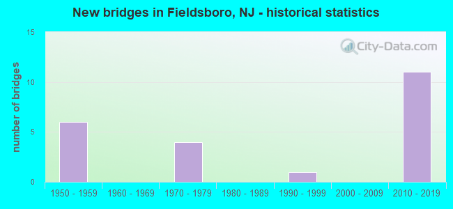
- New bridges - historical statistics
- 61950-1959
- 41970-1979
- 11990-1999
- 112010-2019


- Bridge Condition - Deck
- 63.6%Good
- 36.4%Satisfactory

- Bridge Condition - Superstructure
- 63.6%Very good
- 9.1%Good
- 18.2%Satisfactory
- 9.1%Fair

- Bridge Condition - Substructure
- 36.4%Very good
- 54.5%Good
- 9.1%Satisfactory
Find on map >> Show street view
Structure Number: 328165, Location: 1.4 MI S EXIT 56 OF 295 (Lat: 40.109531, Lng: -74.734881), Route carried "on" structure: County highway 660, Year Built: 1971, Status: Open, Structure Length: 6.52m (21.39ft), Average Daily Traffic: 580 (year 2020), Truck Traffic: 1%, Average Future Daily Traffic: 696 (year 2040), Design Load: HS 20+Mod, Features Intersected: ROUTE I-295
Minimum Vertical Clearance: 30+ m (98+ ft), Kilometerpoint: 10.525, Lanes on structure: 2, Lanes under structure: 6, Owner: State Highway Agency, Approaching Roadway Width: 9.1m (29.9ft), Skew: 1 degrees, Material/Design: Steel, Design/Construction: Stringer/Multi-beam, Number Of Spans In Main Unit: 2, Length of Maximum Span: 31.7m (104.0ft), Curb or Sidewalk Widths: Left: 0.5m (1.6ft), Right: 1.8m (5.9ft), Curb-To-Curb Width: 9.1m (29.9ft), Out-to-Out Width: 12.0m (39.4ft)
Condition: Deck: Satisfactory, Superstructure: Good, Substructure: Good, Operating Rating: 54.4 metric tons, Method Used To Determine Operating Rating: Load Factor (LF), Inventory Rating: 32.7 metric tons, Method Used To Determine Inventory Rating: Load Factor (LF), Structural Evaluation: Better than present minimum criteria, Deck Geometry: Equal to present minimum criteria, Underclear: Somewhat better than minimum adequacy, Approach Roadway Alignment: Better than present minimum criteria, Designated Inspection Frequency: Every 24 months, Inspection Date: September 2020, Deck Structure Type: Concrete Cast-file-Place, Wearing Surface/Protective System: Wearing Surface: Monolithic Concrete
Find on map >> Show street view
Structure Number: 328167, Location: 0.73 MI S OF RT 130 JCT (Lat: 40.125650, Lng: -74.717131), Route carried "on" structure: City street , Year Built: 1971, Status: Open, Structure Length: 6.89m (22.60ft), Average Daily Traffic: 9,646 (year 2020), Truck Traffic: 4%, Average Future Daily Traffic: 11,770 (year 2040), Design Load: HS 20, Features Intersected: I-295, Facility Carried by Structure: RISING SUN ROAD
Minimum Vertical Clearance: 30+ m (98+ ft), Kilometerpoint: 1.062, Lanes on structure: 2, Lanes under structure: 6, Owner: State Highway Agency, Approaching Roadway Width: 12.2m (40.0ft), Skew: 2 degrees, Material/Design: Steel, Design/Construction: Stringer/Multi-beam, Number Of Spans In Main Unit: 2, Length of Maximum Span: 33.5m (109.9ft), Curb or Sidewalk Widths: Left: 1.8m (5.9ft), Right: 0.5m (1.6ft), Curb-To-Curb Width: 9.1m (29.9ft), Out-to-Out Width: 12.0m (39.4ft)
Condition: Deck: Satisfactory, Superstructure: Fair, Substructure: Good, Operating Rating: 56.2 metric tons, Method Used To Determine Operating Rating: Load Factor (LF), Inventory Rating: 33.6 metric tons, Method Used To Determine Inventory Rating: Load Factor (LF), Structural Evaluation: Somewhat better than minimum adequacy, Deck Geometry: Meets minimum limits, Underclear: High priority of corrective action, Approach Roadway Alignment: Equal to present desirable criteria, Length Of Structure Improvement: 6.89m (22.60ft), Designated Inspection Frequency: Every 24 months, Inspection Date: June 2020, Bridge Improvement Cost: $910,000, Roadway Improvement Cost: $165,000, Total Project Cost: $1,256,000 ( Estimate for 2020), Deck Structure Type: Concrete Cast-file-Place, Wearing Surface/Protective System: Wearing Surface: Monolithic Concrete
Find on map >> Show street view
Structure Number: 3E219, Location: 0.9 MI.S.OF RISING SUN RD (Lat: 40.117200, Lng: -74.728289), Route carried "on" structure: City street , Year Built: 1998, Status: Open, Structure Length: 1.16m (3.81ft), Average Daily Traffic: 456 (year 2021), Truck Traffic: 1%, Average Future Daily Traffic: 547 (year 2041), Design Load: HS 25 or greater, Features Intersected: SPRING HILL BROOK, Facility Carried by Structure: AXE FACTORY ROAD
Minimum Vertical Clearance: 30+ m (98+ ft), Kilometerpoint: 0.000, Lanes on structure: 2, Owner: County Highway Agency, Approaching Roadway Width: 9.8m (32.2ft), Material/Design: Prestressed concrete, Design/Construction: Slab, Number Of Spans In Main Unit: 1, Length of Maximum Span: 11.0m (36.1ft), Curb-To-Curb Width: 9.8m (32.2ft), Out-to-Out Width: 11.0m (36.1ft)
Condition: Deck: Good, Superstructure: Very good, Substructure: Very good, Channel: Good, Inventory Rating: 80.7 metric tons, Method Used To Determine Inventory Rating: Load Factor (LF), Structural Evaluation: Equal to present desirable criteria, Deck Geometry: Equal to present minimum criteria, Waterway Adequacy: Equal to present desirable criteria, Approach Roadway Alignment: Equal to present minimum criteria, Designated Inspection Frequency: Every 24 months, Inspection Date: October 2021, Deck Structure Type: Concrete Cast-file-Place, Wearing Surface/Protective System: Wearing Surface: Monolithic Concrete, Deck Protection: Epoxy Coated Reinforcing
Find on map >> Show street view
Structure Number: M05088, Location: AT Interchange 6 (Lat: 40.098475, Lng: -74.729572), Route carried "on" structure: Ramp Interstate 95, Year Built: 2012, Status: Open, Structure Length: 22.46m (73.69ft), Average Daily Traffic: 5,308 (year 2020), Truck Traffic: 14%, Average Future Daily Traffic: 6,477 (year 2040), Design Load: HL 93, Features Intersected: NJ Turnpike, Facility Carried by Structure: Ramp SIT
Minimum Vertical Clearance: 30+ m (98+ ft), Kilometerpoint: 9.254, Lanes on structure: 1, Lanes under structure: 9, Toll: On toll road, Owner: State Toll Authority, Approaching Roadway Width: 11.9m (39.0ft), Material/Design: Steel continuous, Design/Construction: Stringer/Multi-beam, Number Of Spans In Main Unit: 5, Length of Maximum Span: 47.9m (157.2ft), Curb-To-Curb Width: 12.0m (39.4ft), Out-to-Out Width: 13.1m (43.0ft)
Condition: Deck: Good, Superstructure: Very good, Substructure: Good, Operating Rating: 51.5 metric tons, Method Used To Determine Operating Rating: Load and Resistance Factor Rating (LRFR) rating reported by rating factor(RF) method using HL-93 loadings, Inventory Rating: 39.9 metric tons, Method Used To Determine Inventory Rating: Load and Resistance Factor Rating (LRFR) rating reported by rating factor(RF) method using HL-93 loadings, Structural Evaluation: Better than present minimum criteria, Deck Geometry: Superior to present desirable criteria, Underclear: Equal to present minimum criteria, Approach Roadway Alignment: Equal to present desirable criteria, Designated Inspection Frequency: Every 24 months, Critical Feature Inspection Frequency: Every 24 months, Inspection Date: April 2020, Critical Feature Inspection Date: April 2020, Deck Structure Type: Concrete Cast-file-Place, Wearing Surface/Protective System: Wearing Surface: Monolithic Concrete, Deck Protection: Epoxy Coated Reinforcing
Find on map >> Show street view
Structure Number: M05091, Location: Interchange 6 (Lat: 40.093933, Lng: -74.732014), Route carried "on" structure: Ramp Interstate 95, Year Built: 2013, Status: Open, Structure Length: 26.52m (87.01ft), Average Daily Traffic: 4,111 (year 2020), Truck Traffic: 13%, Average Future Daily Traffic: 5,016 (year 2040), Design Load: HL 93, Features Intersected: NJTPK (I-95), Facility Carried by Structure: Ramp SOT
Minimum Vertical Clearance: 30+ m (98+ ft), Kilometerpoint: 8.980, Lanes on structure: 1, Lanes under structure: 12, Toll: On toll road, Owner: State Toll Authority, Approaching Roadway Width: 11.9m (39.0ft), Material/Design: Steel continuous, Design/Construction: Stringer/Multi-beam, Number Of Spans In Main Unit: 6, Length of Maximum Span: 46.9m (153.9ft), Curb-To-Curb Width: 12.0m (39.4ft), Out-to-Out Width: 13.1m (43.0ft)
Condition: Deck: Good, Superstructure: Very good, Substructure: Good, Operating Rating: 50.9 metric tons, Method Used To Determine Operating Rating: Load and Resistance Factor Rating (LRFR) rating reported by rating factor(RF) method using HL-93 loadings, Inventory Rating: 39.2 metric tons, Method Used To Determine Inventory Rating: Load and Resistance Factor Rating (LRFR) rating reported by rating factor(RF) method using HL-93 loadings, Structural Evaluation: Better than present minimum criteria, Deck Geometry: Superior to present desirable criteria, Underclear: Meets minimum limits, Approach Roadway Alignment: Equal to present desirable criteria, Designated Inspection Frequency: Every 24 months, Critical Feature Inspection Frequency: Every 24 months, Inspection Date: May 2020, Critical Feature Inspection Date: May 2020, Deck Structure Type: Concrete Cast-file-Place, Wearing Surface/Protective System: Wearing Surface: Monolithic Concrete, Deck Protection: Epoxy Coated Reinforcing
Find on map >> Show street view
Structure Number: M05095R, Location: AT NJTPK INT. 6 (Lat: 40.095969, Lng: -74.730839), Route carried "on" structure: County highway 678, Year Built: 2013, Status: Open, Structure Length: 12.92m (42.39ft), Average Daily Traffic: 1,150 (year 2020), Truck Traffic: 1%, Average Future Daily Traffic: 1,404 (year 2040), Design Load: HL 93, Features Intersected: NJTPK (I-95), Facility Carried by Structure: Columbus-Hedding R
Minimum Vertical Clearance: 30+ m (98+ ft), Kilometerpoint: 2.060, Lanes on structure: 2, Lanes under structure: 12, Owner: State Toll Authority, Approaching Roadway Width: 10.4m (34.1ft), Skew: 1 degrees, Material/Design: Steel continuous, Design/Construction: Stringer/Multi-beam, Number Of Spans In Main Unit: 3, Length of Maximum Span: 50.6m (166.0ft), Curb-To-Curb Width: 10.4m (34.1ft), Out-to-Out Width: 11.4m (37.4ft)
Condition: Deck: Good, Superstructure: Very good, Substructure: Very good, Operating Rating: 44.4 metric tons, Method Used To Determine Operating Rating: Load and Resistance Factor Rating (LRFR) rating reported by rating factor(RF) method using HL-93 loadings, Inventory Rating: 34.3 metric tons, Method Used To Determine Inventory Rating: Load and Resistance Factor Rating (LRFR) rating reported by rating factor(RF) method using HL-93 loadings, Structural Evaluation: Equal to present desirable criteria, Deck Geometry: Equal to present minimum criteria, Underclear: Meets minimum limits, Approach Roadway Alignment: Equal to present desirable criteria, Designated Inspection Frequency: Every 24 months, Inspection Date: May 2020, Deck Structure Type: Concrete Cast-file-Place, Wearing Surface/Protective System: Wearing Surface: Monolithic Concrete, Deck Protection: Epoxy Coated Reinforcing
Find on map >> Show street view
Structure Number: M05111, Location: Interchange 6 Ramps (Lat: 40.097553, Lng: -74.730381), Route carried "on" structure: Ramp Interstate 95, Year Built: 2013, Status: Open, Structure Length: 30.02m (98.49ft), Average Daily Traffic: 4,287 (year 2020), Truck Traffic: 13%, Average Future Daily Traffic: 5,231 (year 2040), Design Load: HL 93, Features Intersected: NJTPK (I-95), Facility Carried by Structure: Ramp TNO
Minimum Vertical Clearance: 30+ m (98+ ft), Kilometerpoint: 9.302, Lanes on structure: 2, Lanes under structure: 12, Toll: On toll road, Owner: State Toll Authority, Approaching Roadway Width: 14.0m (45.9ft), Material/Design: Steel continuous, Design/Construction: Stringer/Multi-beam, Number Of Spans In Main Unit: 6, Length of Maximum Span: 60.0m (196.9ft), Curb-To-Curb Width: 14.1m (46.3ft), Out-to-Out Width: 15.2m (49.9ft)
Condition: Deck: Good, Superstructure: Very good, Substructure: Very good, Operating Rating: 48.9 metric tons, Method Used To Determine Operating Rating: Load and Resistance Factor Rating (LRFR) rating reported by rating factor(RF) method using HL-93 loadings, Inventory Rating: 37.9 metric tons, Method Used To Determine Inventory Rating: Load and Resistance Factor Rating (LRFR) rating reported by rating factor(RF) method using HL-93 loadings, Structural Evaluation: Equal to present desirable criteria, Deck Geometry: Superior to present desirable criteria, Underclear: Better than present minimum criteria, Approach Roadway Alignment: Equal to present desirable criteria, Designated Inspection Frequency: Every 24 months, Critical Feature Inspection Frequency: Every 24 months, Inspection Date: April 2020, Critical Feature Inspection Date: April 2020, Deck Structure Type: Concrete Cast-file-Place, Wearing Surface/Protective System: Wearing Surface: Monolithic Concrete, Deck Protection: Epoxy Coated Reinforcing
Find on map >> Show street view
Structure Number: M05117, Location: End of Penn Extension (Lat: 40.097872, Lng: -74.729783), Route carried "on" structure: Ramp Interstate 95, Year Built: 2012, Status: Open, Structure Length: 34.53m (113.29ft), Average Daily Traffic: 18,518 (year 2020), Truck Traffic: 15%, Average Future Daily Traffic: 22,596 (year 2040), Design Load: HL 93, Features Intersected: NSO, NSI & SNI Roadways, Facility Carried by Structure: Int. 6 Ramp TNI
Minimum Vertical Clearance: 30+ m (98+ ft), Kilometerpoint: 9.254, Lanes on structure: 2, Lanes under structure: 9, Toll: On toll road, Owner: State Toll Authority, Approaching Roadway Width: 13.4m (44.0ft), Material/Design: Steel continuous, Design/Construction: Stringer/Multi-beam, Number Of Spans In Main Unit: 7, Length of Maximum Span: 55.5m (182.1ft), Curb-To-Curb Width: 13.5m (44.3ft), Out-to-Out Width: 14.6m (47.9ft)
Condition: Deck: Good, Superstructure: Very good, Substructure: Good, Operating Rating: 51.2 metric tons, Method Used To Determine Operating Rating: Load and Resistance Factor Rating (LRFR) rating reported by rating factor(RF) method using HL-93 loadings, Inventory Rating: 39.5 metric tons, Method Used To Determine Inventory Rating: Load and Resistance Factor Rating (LRFR) rating reported by rating factor(RF) method using HL-93 loadings, Structural Evaluation: Better than present minimum criteria, Deck Geometry: Superior to present desirable criteria, Underclear: Somewhat better than minimum adequacy, Approach Roadway Alignment: Equal to present desirable criteria, Designated Inspection Frequency: Every 24 months, Critical Feature Inspection Frequency: Every 24 months, Inspection Date: April 2020, Critical Feature Inspection Date: April 2020, Deck Structure Type: Concrete Cast-file-Place, Wearing Surface/Protective System: Wearing Surface: Monolithic Concrete, Deck Protection: Epoxy Coated Reinforcing
Find on map >> Show street view
Structure Number: M05142R, Location: 0.3 MI NORTH OF EXIT 6 (Lat: 40.101711, Lng: -74.726167), Route carried "on" structure: City street , Year Built: 2011, Status: Open, Structure Length: 15.18m (49.80ft), Average Daily Traffic: 3,533 (year 2020), Truck Traffic: 1%, Average Future Daily Traffic: 4,311 (year 2040), Design Load: HL 93, Features Intersected: Turnpike Mainline, Facility Carried by Structure: Mansfield Rd West
Minimum Vertical Clearance: 30+ m (98+ ft), Kilometerpoint: 0.000, Lanes on structure: 2, Lanes under structure: 20, Owner: State Toll Authority, Approaching Roadway Width: 9.8m (32.2ft), Material/Design: Steel continuous, Design/Construction: Stringer/Multi-beam, Number Of Spans In Main Unit: 4, Length of Maximum Span: 41.8m (137.1ft), Curb-To-Curb Width: 9.8m (32.2ft), Out-to-Out Width: 10.8m (35.4ft)
Condition: Deck: Good, Superstructure: Very good, Substructure: Very good, Operating Rating: 36.6 metric tons, Method Used To Determine Operating Rating: Load and Resistance Factor Rating (LRFR) rating reported by rating factor(RF) method using HL-93 loadings, Inventory Rating: 28.5 metric tons, Method Used To Determine Inventory Rating: Load and Resistance Factor Rating (LRFR) rating reported by rating factor(RF) method using HL-93 loadings, Structural Evaluation: Better than present minimum criteria, Deck Geometry: Meets minimum limits, Underclear: Somewhat better than minimum adequacy, Approach Roadway Alignment: Equal to present desirable criteria, Designated Inspection Frequency: Every 24 months, Inspection Date: May 2020, Deck Structure Type: Concrete Cast-file-Place, Wearing Surface/Protective System: Wearing Surface: Monolithic Concrete, Deck Protection: Epoxy Coated Reinforcing
Find on map >> Show street view
Structure Number: P00559E, Location: 0.5 MI WEST OF EXIT 6 (Lat: 40.097311, Lng: -74.732361), Route carried "on" structure: Other road 95, Year Built: 1956, Status: Open, Structure Length: 9.51m (31.20ft), Average Daily Traffic: 19,914 (year 2020), Truck Traffic: 12%, Average Future Daily Traffic: 24,299 (year 2040), Design Load: HS 20, Features Intersected: Hedding Rd & Ramp ST
Minimum Vertical Clearance: 30+ m (98+ ft), Kilometerpoint: 9.028, Lanes on structure: 3, Lanes under structure: 4, Base Highway Network: Yes, Toll: On toll road, Owner: State Toll Authority, Approaching Roadway Width: 16.8m (55.1ft), Skew: 3 degrees, Material/Design: Steel continuous, Design/Construction: Stringer/Multi-beam, Number Of Spans In Main Unit: 4, Length of Maximum Span: 31.7m (104.0ft), Curb or Sidewalk Widths: Left: 0.6m (2.0ft), Right: 0.6m (2.0ft), Curb-To-Curb Width: 15.8m (51.8ft), Out-to-Out Width: 17.7m (58.1ft)
Condition: Deck: Satisfactory, Superstructure: Satisfactory, Substructure: Satisfactory, Operating Rating: 19.1 metric tons, Method Used To Determine Operating Rating: Load and Resistance Factor Rating (LRFR) rating reported by rating factor(RF) method using HL-93 loadings, Inventory Rating: 14.6 metric tons, Method Used To Determine Inventory Rating: Load and Resistance Factor Rating (LRFR) rating reported by rating factor(RF) method using HL-93 loadings, Structural Evaluation: High priority of corrective action, Deck Geometry: Somewhat better than minimum adequacy, Underclear: Somewhat better than minimum adequacy, Approach Roadway Alignment: Equal to present desirable criteria, Length Of Structure Improvement: 9.51m (31.20ft), Designated Inspection Frequency: Every 24 months, Inspection Date: April 2020, Bridge Improvement Cost: $5,570,000, Roadway Improvement Cost: $1,170,000, Total Project Cost: $9,300,000 ( Estimate for 2016), Deck Structure Type: Concrete Cast-file-Place, Wearing Surface/Protective System: Wearing Surface: Bituminous, Membrane: Preformed Fabric
Find on map >> Show street view
Structure Number: P00559W, Location: 2.4 MI EAST OF INT 6 TOLL (Lat: 40.097522, Lng: -74.732564), Route carried "on" structure: Interstate 95, Year Built: 1956, Year Reconstructed: 2011, Status: Open, Structure Length: 10.58m (34.71ft), Average Daily Traffic: 20,195 (year 2020), Truck Traffic: 12%, Average Future Daily Traffic: 24,642 (year 2040), Design Load: HS 20, Features Intersected: HEDDING RD & RAMP ST WB
Minimum Vertical Clearance: 30+ m (98+ ft), Kilometerpoint: 9.028, Lanes on structure: 4, Lanes under structure: 4, Base Highway Network: Yes, Toll: On toll road, Owner: State Toll Authority, Approaching Roadway Width: 19.5m (64.0ft), Skew: 3 degrees, Material/Design: Steel continuous, Design/Construction: Stringer/Multi-beam, Number Of Spans In Main Unit: 4, Length of Maximum Span: 32.6m (107.0ft), Curb or Sidewalk Widths: Left: 0.6m (2.0ft), Right: 0.0m, Curb-To-Curb Width: 19.5m (64.0ft), Out-to-Out Width: 21.3m (69.9ft)
Condition: Deck: Satisfactory, Superstructure: Satisfactory, Substructure: Good, Operating Rating: 19.1 metric tons, Method Used To Determine Operating Rating: Load and Resistance Factor Rating (LRFR) rating reported by rating factor(RF) method using HL-93 loadings, Inventory Rating: 14.9 metric tons, Method Used To Determine Inventory Rating: Load and Resistance Factor Rating (LRFR) rating reported by rating factor(RF) method using HL-93 loadings, Structural Evaluation: High priority of corrective action, Deck Geometry: Somewhat better than minimum adequacy, Underclear: Meets minimum limits, Approach Roadway Alignment: Equal to present desirable criteria, Length Of Structure Improvement: 10.58m (34.71ft), Designated Inspection Frequency: Every 24 months, Inspection Date: January 2020, Bridge Improvement Cost: $7,443,000, Roadway Improvement Cost: $1,564,000, Total Project Cost: $12,429,000 ( Estimate for 2018), Deck Structure Type: Concrete Cast-file-Place, Wearing Surface/Protective System: Wearing Surface: Latex Concrete
Find on map >> Show street view
Structure Number: 328165, Location: 1.4 MI S EXIT 56 OF 295 (Lat: 40.109531, Lng: -74.734881), Route carried "under" structure: Interstate 295, Year Built: 1971, Structure Length: 0. m, Average Daily Traffic: 89,110 (year 2020), Truck Traffic: 9%, Features Intersected: ROUTE I-295, Facility Carried by Structure: OLD YORK RD(CR660)
Minimum Vertical Clearance: 5.05m (16.57ft), Kilometerpoint: 87.886, Lanes on structure: 2, Lanes under structure: 6, Material/Design: Steel, Design/Construction: Stringer/Multi-beam, Length of Maximum Span: 31.7m (104.0ft)
Find on map >> Show street view
Structure Number: 328167, Location: 0.73 MI S OF RT 130 JCT (Lat: 40.125650, Lng: -74.717131), Route carried "under" structure: Interstate 295, Year Built: 1971, Structure Length: 0. m, Average Daily Traffic: 70,545 (year 2020), Truck Traffic: 9%, Features Intersected: I-295, Facility Carried by Structure: RISING SUN ROAD
Minimum Vertical Clearance: 4.60m (15.09ft), Kilometerpoint: 90.284, Lanes on structure: 2, Lanes under structure: 6, Material/Design: Steel, Design/Construction: Stringer/Multi-beam, Length of Maximum Span: 33.5m (109.9ft)
Find on map >> Show street view
Structure Number: M05088, Location: AT Interchange 6 (Lat: 40.098475, Lng: -74.729572), Route carried "under" structure: Other road NJTPK, Year Built: 2012, Structure Length: 0. m, Average Daily Traffic: 81,703 (year 2020), Truck Traffic: 14%, Features Intersected: NJ Turnpike, Facility Carried by Structure: Ramp SIT
Minimum Vertical Clearance: 6.35m (20.83ft), Kilometerpoint: 82.592, Lanes on structure: 1, Lanes under structure: 9, Toll: On toll road, Material/Design: Steel continuous, Design/Construction: Stringer/Multi-beam, Length of Maximum Span: 47.9m (157.2ft)
Find on map >> Show street view
Structure Number: M05091, Location: Interchange 6 (Lat: 40.093933, Lng: -74.732014), Route carried "under" structure: Interstate 95, Year Built: 2013, Structure Length: 0. m, Average Daily Traffic: 117,227 (year 2020), Truck Traffic: 13%, Features Intersected: NJTPK (I-95), Facility Carried by Structure: Ramp SOT
Minimum Vertical Clearance: 9.12m (29.92ft), Kilometerpoint: 8.980, Lanes on structure: 1, Lanes under structure: 12, Toll: On toll road, Material/Design: Steel continuous, Design/Construction: Stringer/Multi-beam, Length of Maximum Span: 46.9m (153.9ft)
Find on map >> Show street view
Structure Number: M05095R, Location: AT NJTPK INT. 6 (Lat: 40.095969, Lng: -74.730839), Route carried "under" structure: Interstate 95, Year Built: 2013, Structure Length: 0. m, Average Daily Traffic: 111,538 (year 2020), Truck Traffic: 12%, Features Intersected: NJTPK (I-95), Facility Carried by Structure: Columbus-Hedding R
Minimum Vertical Clearance: 5.52m (18.11ft), Kilometerpoint: 82.350, Lanes on structure: 2, Lanes under structure: 12, Toll: On toll road, Material/Design: Steel continuous, Design/Construction: Stringer/Multi-beam, Length of Maximum Span: 50.6m (166.0ft)
Find on map >> Show street view
Structure Number: M05117, Location: End of Penn Extension (Lat: 40.097872, Lng: -74.729783), Route carried "under" structure: Other road NJTPK, Year Built: 2012, Structure Length: 0. m, Average Daily Traffic: 53,395 (year 2020), Truck Traffic: 18%, Features Intersected: NSO, NSI & SNI Roadways, Facility Carried by Structure: Int. 6 Ramp TNI
Minimum Vertical Clearance: 6.80m (22.31ft), Kilometerpoint: 82.592, Lanes on structure: 2, Lanes under structure: 9, Toll: On toll road, Material/Design: Steel continuous, Design/Construction: Stringer/Multi-beam, Length of Maximum Span: 55.5m (182.1ft)
Find on map >> Show street view
Structure Number: M05142R, Location: 0.3 MI NORTH OF EXIT 6 (Lat: 40.101711, Lng: -74.726167), Route carried "under" structure: Interstate 95, Year Built: 2011, Structure Length: 0. m, Average Daily Traffic: 111,538 (year 2020), Truck Traffic: 14%, Features Intersected: Turnpike Mainline, Facility Carried by Structure: Mansfield Rd West
Minimum Vertical Clearance: 5.64m (18.50ft), Kilometerpoint: 9.769, Lanes on structure: 2, Lanes under structure: 20, Toll: On toll road, Material/Design: Steel continuous, Design/Construction: Stringer/Multi-beam, Length of Maximum Span: 41.8m (137.1ft)
Find on map >> Show street view
Structure Number: P00559E, Location: 0.5 MI WEST OF EXIT 6 (Lat: 40.097311, Lng: -74.732361), Route carried "under" structure: County highway 678, Year Built: 1956, Structure Length: 0. m, Average Daily Traffic: 1,147 (year 2020), Truck Traffic: 1%, Features Intersected: Hedding Rd & Ramp ST, Facility Carried by Structure: NJ TPK (I-95) EB
Minimum Vertical Clearance: 4.98m (16.34ft), Kilometerpoint: 2.060, Lanes on structure: 3, Lanes under structure: 2, Material/Design: Steel continuous, Design/Construction: Stringer/Multi-beam, Length of Maximum Span: 31.7m (104.0ft)
Find on map >> Show street view
Structure Number: P00559E, Location: 0.5 MI WEST OF EXIT 6 (Lat: 40.097311, Lng: -74.732361), Route carried "under" structure: Ramp Other road 95, Year Built: 1956, Structure Length: 0. m, Average Daily Traffic: 2,123 (year 2020), Truck Traffic: 12%, Features Intersected: Hedding Rd & Ramp ST
Minimum Vertical Clearance: 4.98m (16.34ft), Kilometerpoint: 9.028, Lanes on structure: 3, Lanes under structure: 2, Toll: On toll road, Material/Design: Steel continuous, Design/Construction: Stringer/Multi-beam, Length of Maximum Span: 31.7m (104.0ft)
Find on map >> Show street view
Structure Number: P00559W, Location: 2.4 MI EAST OF INT 6 TOLL (Lat: 40.097522, Lng: -74.732564), Route carried "under" structure: County highway 678, Year Built: 1956, Structure Length: 0. m, Average Daily Traffic: 1,472 (year 2020), Truck Traffic: 1%, Features Intersected: HEDDING RD & RAMP ST WB, Facility Carried by Structure: NJ TPK (I-95) WB
Minimum Vertical Clearance: 4.77m (15.65ft), Kilometerpoint: 2.285, Lanes on structure: 4, Lanes under structure: 2, Material/Design: Steel continuous, Design/Construction: Stringer/Multi-beam, Length of Maximum Span: 32.6m (107.0ft)
Find on map >> Show street view
Structure Number: P00559W, Location: 2.4 MI EAST OF INT 6 TOLL (Lat: 40.097522, Lng: -74.732564), Route carried "under" structure: Ramp Interstate 95, Year Built: 1956, Structure Length: 0. m, Average Daily Traffic: 2,123 (year 2020), Truck Traffic: 12%, Features Intersected: HEDDING RD & RAMP ST WB
Minimum Vertical Clearance: 5.26m (17.26ft), Kilometerpoint: 8.980, Lanes on structure: 4, Lanes under structure: 2, Toll: On toll road, Material/Design: Steel continuous, Design/Construction: Stringer/Multi-beam, Length of Maximum Span: 32.6m (107.0ft)