Bridge Statistics for Fillmore, Utah (UT)
Condition, Traffic, Stress, Structural Evaluation, Project Costs
- National Bridge Inventory (NBI) Statistics
- 15Number of bridges
- 131ft / 39.6mTotal length
- 167,246Total average daily traffic
- 51,451Total average daily truck traffic
- National Bridge Inventory (NBI) Registered Bridges for Fillmore
- No street view available for this location
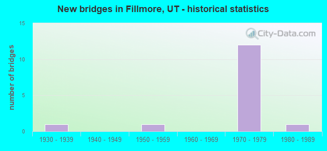
- New bridges - historical statistics
- 11930-1939
- 11950-1959
- 121970-1979
- 11980-1989

- Reconstructed bridges - Historical Statistics
- 11950-1959
- 01960-1969
- 01970-1979
- 01980-1989
- 01990-1999
- 12000-2009


- Bridge Condition - Deck
- 25.0%Good
- 75.0%Satisfactory

- Bridge Condition - Superstructure
- 12.5%Good
- 87.5%Satisfactory

- Bridge Condition - Substructure
- 25.0%Good
- 50.0%Satisfactory
- 25.0%Fair

- Bridge Condition - Channel
- 60.0%Good
- 20.0%Satisfactory
- 20.0%Fair
Find on map >> Show street view
Structure Number: C 445, Location: WEST SIDE OF FILLMORE (Lat: 38.978142, Lng: -112.337900), Route carried "on" structure: State highway 100, Year Built: 1972, Status: Open, Structure Length: 7.50m (24.61ft), Average Daily Traffic: 1,216 (year 2020), Truck Traffic: 21%, Average Future Daily Traffic: 1,520 (year 2040), Design Load: HS 20+Mod, Features Intersected: I-15 (SR-15) NBL & SBL
Minimum Vertical Clearance: 30+ m (98+ ft), Kilometerpoint: 1.245, Lanes on structure: 2, Lanes under structure: 4, Owner: State Highway Agency, Approaching Roadway Width: 11.1m (36.4ft), Material/Design: Steel continuous, Design/Construction: Stringer/Multi-beam, Number Of Spans In Main Unit: 2, Length of Maximum Span: 36.9m (121.1ft), Curb-To-Curb Width: 11.1m (36.4ft), Out-to-Out Width: 12.2m (40.0ft)
Condition: Deck: Good, Superstructure: Satisfactory, Substructure: Satisfactory, Operating Rating: 45.7 metric tons, Method Used To Determine Operating Rating: Load and Resistance Factor Rating (LRFR) rating reported by rating factor(RF) method using HL-93 loadings, Inventory Rating: 32.7 metric tons, Method Used To Determine Inventory Rating: Load and Resistance Factor Rating (LRFR) rating reported by rating factor(RF) method using HL-93 loadings, Structural Evaluation: Equal to present minimum criteria, Deck Geometry: Equal to present minimum criteria, Underclear: Equal to present minimum criteria, Approach Roadway Alignment: Equal to present minimum criteria, Designated Inspection Frequency: Every 24 months, Inspection Date: Febuary 2021, Deck Structure Type: Concrete Cast-file-Place, Wearing Surface/Protective System: Wearing Surface: Bituminous, Membrane: Preformed Fabric
Find on map >> Show street view
Structure Number: C 58, Location: SO.FILLMORE INTERCHANGE (Lat: 38.948800, Lng: -112.350089), Route carried "on" structure: State highway 99, Year Built: 1972, Status: Open, Structure Length: 7.74m (25.39ft), Average Daily Traffic: 2,537 (year 2020), Truck Traffic: 24%, Average Future Daily Traffic: 3,171 (year 2040), Design Load: HS 20+Mod, Features Intersected: I-15 (SR-15) NBL & SBL
Minimum Vertical Clearance: 30+ m (98+ ft), Kilometerpoint: 0.109, Lanes on structure: 2, Lanes under structure: 4, Owner: State Highway Agency, Approaching Roadway Width: 15.4m (50.5ft), Material/Design: Steel continuous, Design/Construction: Stringer/Multi-beam, Number Of Spans In Main Unit: 2, Length of Maximum Span: 38.1m (125.0ft), Curb-To-Curb Width: 15.4m (50.5ft), Out-to-Out Width: 16.4m (53.8ft)
Condition: Deck: Satisfactory, Superstructure: Satisfactory, Substructure: Satisfactory, Operating Rating: 50.2 metric tons, Method Used To Determine Operating Rating: Load and Resistance Factor Rating (LRFR) rating reported by rating factor(RF) method using HL-93 loadings, Inventory Rating: 48.9 metric tons, Method Used To Determine Inventory Rating: Load Factor (LF) rating reported by rating factor (RF) method using MS18 loading, Structural Evaluation: Equal to present minimum criteria, Deck Geometry: Superior to present desirable criteria, Underclear: Superior to present desirable criteria, Approach Roadway Alignment: Equal to present minimum criteria, Designated Inspection Frequency: Every 24 months, Inspection Date: Febuary 2021, Deck Structure Type: Concrete Cast-file-Place, Wearing Surface/Protective System: Wearing Surface: Bituminous, Membrane: Preformed Fabric
Find on map >> Show street view
Structure Number: C 581, Location: WEST SIDE OF FILLMORE (Lat: 38.964508, Lng: -112.344833), Route carried "on" structure: City street , Year Built: 1972, Status: Open, Structure Length: 8.11m (26.61ft), Average Daily Traffic: 2,000 (year 2020), Average Future Daily Traffic: 2,500 (year 2040), Design Load: HS 20+Mod, Features Intersected: I-15 (SR-15) NBL & SBL, Facility Carried by Structure: 200 SOUTH STREET
Minimum Vertical Clearance: 30+ m (98+ ft), Kilometerpoint: 0.751, Lanes on structure: 2, Lanes under structure: 4, Owner: State Highway Agency, Approaching Roadway Width: 9.3m (30.5ft), Skew: 1 degrees, Material/Design: Steel continuous, Design/Construction: Stringer/Multi-beam, Number Of Spans In Main Unit: 2, Length of Maximum Span: 39.9m (130.9ft), Curb-To-Curb Width: 9.3m (30.5ft), Out-to-Out Width: 10.4m (34.1ft)
Condition: Deck: Good, Superstructure: Satisfactory, Substructure: Good, Operating Rating: 64.8 metric tons, Method Used To Determine Operating Rating: Load and Resistance Factor Rating (LRFR) rating reported by rating factor(RF) method using HL-93 loadings, Inventory Rating: 44.4 metric tons, Method Used To Determine Inventory Rating: Load Factor (LF) rating reported by rating factor (RF) method using MS18 loading, Structural Evaluation: Equal to present minimum criteria, Deck Geometry: Somewhat better than minimum adequacy, Underclear: Equal to present minimum criteria, Approach Roadway Alignment: Equal to present minimum criteria, Designated Inspection Frequency: Every 24 months, Inspection Date: Febuary 2021, Deck Structure Type: Concrete Cast-file-Place, Wearing Surface/Protective System: Wearing Surface: Bituminous, Membrane: Preformed Fabric
Find on map >> Show street view
Structure Number: C 749, Location: 50 WEST 400 NO. FILLMORE (Lat: 38.977656, Lng: -112.325147), Route carried "on" structure: State highway 100, Year Built: 1988, Status: Open, Structure Length: 1.38m (4.53ft), Average Daily Traffic: 1,216 (year 2020), Truck Traffic: 21%, Average Future Daily Traffic: 1,520 (year 2040), Design Load: HS 20+Mod, Features Intersected: CHALK CREEK
Minimum Vertical Clearance: 30+ m (98+ ft), Kilometerpoint: 0.128, Lanes on structure: 2, Owner: State Highway Agency, Approaching Roadway Width: 11.0m (36.1ft), Skew: 2 degrees, Material/Design: Steel, Design/Construction: Stringer/Multi-beam, Number Of Spans In Main Unit: 1, Length of Maximum Span: 13.0m (42.7ft), Curb or Sidewalk Widths: Left: 1.2m (3.9ft), Right: 1.2m (3.9ft), Curb-To-Curb Width: 11.9m (39.0ft), Out-to-Out Width: 15.6m (51.2ft)
Condition: Deck: Satisfactory, Superstructure: Good, Substructure: Good, Channel: Fair, Operating Rating: 78.1 metric tons, Method Used To Determine Operating Rating: Load and Resistance Factor Rating (LRFR) rating reported by rating factor(RF) method using HL-93 loadings, Inventory Rating: 71.9 metric tons, Method Used To Determine Inventory Rating: Load and Resistance Factor Rating (LRFR) rating reported by rating factor(RF) method using HL-93 loadings, Structural Evaluation: Better than present minimum criteria, Deck Geometry: Equal to present minimum criteria, Waterway Adequacy: Equal to present minimum criteria, Approach Roadway Alignment: Equal to present desirable criteria, Designated Inspection Frequency: Every 24 months, Inspection Date: Febuary 2021, Deck Structure Type: Concrete Cast-file-Place, Wearing Surface/Protective System: Wearing Surface: Monolithic Concrete, Deck Protection: Epoxy Coated Reinforcing
Find on map >> Show street view
Structure Number: D 6, Location: 300 NORTH IN FILLMORE (Lat: 38.975175, Lng: -112.323678), Route carried "on" structure: State highway 99, Year Built: 1934, Year Reconstructed: 1957, Status: Open, Structure Length: 1.52m (4.99ft), Average Daily Traffic: 5,994 (year 2020), Truck Traffic: 24%, Average Future Daily Traffic: 7,493 (year 2040), Design Load: H 15, Features Intersected: CHALK CREEK
Minimum Vertical Clearance: 30+ m (98+ ft), Kilometerpoint: 4.689, Lanes on structure: 2, Owner: State Highway Agency, Approaching Roadway Width: 18.3m (60.0ft), Skew: 24 degrees, Material/Design: Concrete, Design/Construction: Frame, Number Of Spans In Main Unit: 1, Length of Maximum Span: 13.7m (44.9ft), Curb or Sidewalk Widths: Left: 1.5m (4.9ft), Right: 1.5m (4.9ft), Curb-To-Curb Width: 18.3m (60.0ft), Out-to-Out Width: 21.4m (70.2ft)
Condition: Deck: Satisfactory, Superstructure: Satisfactory, Substructure: Satisfactory, Channel: Satisfactory, Operating Rating: 37.3 metric tons, Method Used To Determine Operating Rating: Load and Resistance Factor Rating (LRFR) rating reported by rating factor(RF) method using HL-93 loadings, Inventory Rating: 24.3 metric tons, Method Used To Determine Inventory Rating: Load and Resistance Factor Rating (LRFR) rating reported by rating factor(RF) method using HL-93 loadings, Structural Evaluation: Equal to present minimum criteria, Deck Geometry: Superior to present desirable criteria, Waterway Adequacy: Meets minimum limits, Approach Roadway Alignment: Equal to present desirable criteria, Designated Inspection Frequency: Every 24 months, Inspection Date: Febuary 2021, Deck Structure Type: Concrete Cast-file-Place, Wearing Surface/Protective System: Wearing Surface: Bituminous, Membrane: Built-up
Find on map >> Show street view
Structure Number: E1798, Location: 0.5 MI.SO.NO.FILLMORE INT (Lat: 38.986150, Lng: -112.330192), Route carried "on" structure: Interstate 15, Year Built: 1972, Status: Open, Structure Length: 0.98m (3.22ft), Average Daily Traffic: 21,200 (year 2020), Truck Traffic: 32%, Average Future Daily Traffic: 26,500 (year 2040), Design Load: HS 20+Mod, Features Intersected: CHALK CREEK
Minimum Vertical Clearance: 30+ m (98+ ft), Kilometerpoint: 267.934, Lanes on structure: 4, Base Highway Network: Yes, Owner: State Highway Agency, Approaching Roadway Width: 24.4m (80.1ft), Skew: 20 degrees, Material/Design: Concrete continuous, Design/Construction: Culvert, Number Of Spans In Main Unit: 2, Length of Maximum Span: 4.6m (15.1ft), Curb-To-Curb Width: 24.4m (80.1ft), Out-to-Out Width: 58.4m (191.6ft)
Condition: Channel: Good, Culverts: Satisfactory, Operating Rating: 55.1 metric tons, Method Used To Determine Operating Rating: Load and Resistance Factor Rating (LRFR) rating reported by rating factor(RF) method using HL-93 loadings, Inventory Rating: 36.9 metric tons, Method Used To Determine Inventory Rating: Load and Resistance Factor Rating (LRFR) rating reported by rating factor(RF) method using HL-93 loadings, Structural Evaluation: Equal to present minimum criteria, Deck Geometry: Superior to present desirable criteria, Waterway Adequacy: Equal to present minimum criteria, Approach Roadway Alignment: Equal to present desirable criteria, Designated Inspection Frequency: Every 24 months, Inspection Date: Febuary 2021
Find on map >> Show street view
Structure Number: E18, Location: 0.4 MI.SO.NO.FILLMORE INT (Lat: 38.987036, Lng: -112.329117), Route carried "on" structure: Interstate 15, Year Built: 1972, Status: Open, Structure Length: 1.14m (3.74ft), Average Daily Traffic: 21,200 (year 2020), Truck Traffic: 32%, Average Future Daily Traffic: 26,500 (year 2040), Design Load: HS 20+Mod, Features Intersected: CHALK CREEK OVERFLOW CH.
Minimum Vertical Clearance: 30+ m (98+ ft), Kilometerpoint: 268.069, Lanes on structure: 4, Base Highway Network: Yes, Owner: State Highway Agency, Approaching Roadway Width: 24.4m (80.1ft), Skew: 20 degrees, Material/Design: Concrete continuous, Design/Construction: Culvert, Number Of Spans In Main Unit: 2, Length of Maximum Span: 5.3m (17.4ft)
Condition: Channel: Good, Culverts: Satisfactory, Operating Rating: 39.2 metric tons, Method Used To Determine Operating Rating: Load and Resistance Factor Rating (LRFR) rating reported by rating factor(RF) method using HL-93 loadings, Inventory Rating: 38.9 metric tons, Method Used To Determine Inventory Rating: Load and Resistance Factor Rating (LRFR) rating reported by rating factor(RF) method using HL-93 loadings, Structural Evaluation: Equal to present minimum criteria, Approach Roadway Alignment: Equal to present desirable criteria, Designated Inspection Frequency: Every 24 months, Inspection Date: Febuary 2021
Find on map >> Show street view
Structure Number: 1F 203, Location: NO.FILLMORE INTERCHANGE (Lat: 38.991806, Lng: -112.323764), Route carried "on" structure: Interstate 15, Year Built: 1972, Status: Open, Structure Length: 5.20m (17.06ft), Average Daily Traffic: 21,200 (year 2020), Truck Traffic: 32%, Average Future Daily Traffic: 26,500 (year 2040), Design Load: HS 20, Features Intersected: SR-99, INTCHG. X-ROAD
Minimum Vertical Clearance: 30+ m (98+ ft), Kilometerpoint: 268.773, Lanes on structure: 2, Lanes under structure: 3, Base Highway Network: Yes, Owner: State Highway Agency, Approaching Roadway Width: 12.3m (40.4ft), Skew: 2 degrees, Material/Design: Prestressed concrete, Design/Construction: Stringer/Multi-beam, Number Of Spans In Main Unit: 3, Length of Maximum Span: 25.9m (85.0ft), Curb-To-Curb Width: 12.3m (40.4ft), Out-to-Out Width: 13.4m (44.0ft)
Condition: Deck: Satisfactory, Superstructure: Satisfactory, Substructure: Fair, Operating Rating: 37.6 metric tons, Method Used To Determine Operating Rating: Load Factor (LF) rating reported by rating factor (RF) method using MS18 loading, Inventory Rating: 26.2 metric tons, Method Used To Determine Inventory Rating: Load Factor (LF) rating reported by rating factor (RF) method using MS18 loading, Structural Evaluation: Somewhat better than minimum adequacy, Deck Geometry: Better than present minimum criteria, Underclear: Superior to present desirable criteria, Approach Roadway Alignment: Equal to present minimum criteria, Designated Inspection Frequency: Every 24 months, Inspection Date: Febuary 2021, Deck Structure Type: Concrete Cast-file-Place, Wearing Surface/Protective System: Wearing Surface: Bituminous, Membrane: Preformed Fabric
Find on map >> Show street view
Structure Number: 3F 203, Location: NORTH FILLMORE INTCHG. (Lat: 38.992542, Lng: -112.323467), Route carried "on" structure: Interstate 15, Year Built: 1972, Status: Open, Structure Length: 5.20m (17.06ft), Average Daily Traffic: 21,200 (year 2020), Truck Traffic: 32%, Average Future Daily Traffic: 26,500 (year 2040), Design Load: HS 20+Mod, Features Intersected: SR-99, INTCHG. X-ROAD
Minimum Vertical Clearance: 30+ m (98+ ft), Kilometerpoint: 268.646, Lanes on structure: 2, Lanes under structure: 2, Base Highway Network: Yes, Owner: State Highway Agency, Approaching Roadway Width: 12.3m (40.4ft), Skew: 2 degrees, Material/Design: Prestressed concrete, Design/Construction: Stringer/Multi-beam, Number Of Spans In Main Unit: 3, Length of Maximum Span: 25.9m (85.0ft), Curb-To-Curb Width: 12.3m (40.4ft), Out-to-Out Width: 13.4m (44.0ft)
Condition: Deck: Satisfactory, Superstructure: Satisfactory, Substructure: Fair, Operating Rating: 32.7 metric tons, Method Used To Determine Operating Rating: Load and Resistance Factor Rating (LRFR) rating reported by rating factor(RF) method using HL-93 loadings, Inventory Rating: 20.4 metric tons, Method Used To Determine Inventory Rating: Load Factor (LF) rating reported by rating factor (RF) method using MS18 loading, Structural Evaluation: Somewhat better than minimum adequacy, Deck Geometry: Better than present minimum criteria, Underclear: Better than present minimum criteria, Approach Roadway Alignment: Equal to present desirable criteria, Designated Inspection Frequency: Every 24 months, Inspection Date: Febuary 2021, Deck Structure Type: Concrete Cast-file-Place, Wearing Surface/Protective System: Wearing Surface: Bituminous, Membrane: Preformed Fabric
Find on map >> Show street view
Structure Number: 40801000001016, Location: 3 MI EAST OF FILLMORE (Lat: 38.948850, Lng: -112.266489), Route carried "on" structure: Federal lands road 40152, Year Built: 1958, Year Reconstructed: 2008, Status: Open, Structure Length: 0.79m (2.59ft), Average Daily Traffic: 100 (year 1990), Average Future Daily Traffic: 150 (year 2042), Design Load: H 20, Features Intersected: CHALK CREEK, Facility Carried by Structure: ROAD
Minimum Vertical Clearance: 30+ m (98+ ft), Kilometerpoint: 0.800, Lanes on structure: 1, Owner: U.S. Forest Service, Approaching Roadway Width: 5.5m (18.0ft), Skew: 3 degrees, Material/Design: Wood or Timber, Design/Construction: Stringer/Multi-beam, Number Of Spans In Main Unit: 1, Length of Maximum Span: 7.6m (24.9ft), Curb or Sidewalk Widths: Left: 0.2m (0.7ft), Right: 0.2m (0.7ft), Curb-To-Curb Width: 4.3m (14.1ft), Out-to-Out Width: 4.7m (15.4ft)
Condition: Deck: Satisfactory, Superstructure: Satisfactory, Substructure: Satisfactory, Channel: Good, Operating Rating: 23.0 metric tons, Method Used To Determine Operating Rating: Load and Resistance Factor Rating (LRFR) rating reported by rating factor(RF) method using HL-93 loadings, Inventory Rating: 17.8 metric tons, Method Used To Determine Inventory Rating: Load and Resistance Factor Rating (LRFR) rating reported by rating factor(RF) method using HL-93 loadings, Structural Evaluation: Somewhat better than minimum adequacy, Deck Geometry: Equal to present minimum criteria, Waterway Adequacy: Superior to present desirable criteria, Approach Roadway Alignment: Equal to present minimum criteria, Designated Inspection Frequency: Every 24 months, Inspection Date: August 2020, Deck Structure Type: Wood or Timber, Wearing Surface/Protective System: Wearing Surface: Bituminous
Find on map >> Show street view
Structure Number: C 445, Location: WEST SIDE OF FILLMORE (Lat: 38.978142, Lng: -112.337900), Route carried "under" structure: Interstate 15, Year Built: 1972, Structure Length: 0. m, Average Daily Traffic: 21,200 (year 2020), Truck Traffic: 32%, Features Intersected: I-15 (SR-15) NBL & SBL, Facility Carried by Structure: SR-100
Minimum Vertical Clearance: 5.05m (16.57ft), Kilometerpoint: 266.358, Lanes on structure: 2, Lanes under structure: 4, Material/Design: Steel continuous, Design/Construction: Stringer/Multi-beam, Length of Maximum Span: 36.9m (121.1ft)
Find on map >> Show street view
Structure Number: C 58, Location: SO.FILLMORE INTERCHANGE (Lat: 38.948800, Lng: -112.350089), Route carried "under" structure: Interstate 15, Year Built: 1972, Structure Length: 0. m, Average Daily Traffic: 21,441 (year 2020), Truck Traffic: 32%, Features Intersected: I-15 (SR-15) NBL & SBL, Facility Carried by Structure: SR-99,INT.X-RD.
Minimum Vertical Clearance: 5.26m (17.26ft), Kilometerpoint: 262.919, Lanes on structure: 2, Lanes under structure: 4, Material/Design: Steel continuous, Design/Construction: Stringer/Multi-beam, Length of Maximum Span: 38.1m (125.0ft)
Find on map >> Show street view
Structure Number: C 581, Location: WEST SIDE OF FILLMORE (Lat: 38.964508, Lng: -112.344833), Route carried "under" structure: Interstate 15, Year Built: 1972, Structure Length: 0. m, Average Daily Traffic: 21,200 (year 2020), Truck Traffic: 32%, Features Intersected: I-15 (SR-15) NBL & SBL, Facility Carried by Structure: 200 SOUTH STREET
Minimum Vertical Clearance: 5.05m (16.57ft), Kilometerpoint: 264.744, Lanes on structure: 2, Lanes under structure: 4, Material/Design: Steel continuous, Design/Construction: Stringer/Multi-beam, Length of Maximum Span: 39.9m (130.9ft)
Find on map >> Show street view
Structure Number: 1F 203, Location: NO.FILLMORE INTERCHANGE (Lat: 38.991806, Lng: -112.323764), Route carried "under" structure: State highway 99, Year Built: 1972, Structure Length: 0. m, Average Daily Traffic: 2,771 (year 2020), Truck Traffic: 24%, Features Intersected: SR-99, INTCHG. X-ROAD, Facility Carried by Structure: I-15 (SR-15) NBL
Minimum Vertical Clearance: 5.41m (17.75ft), Kilometerpoint: 6.613, Lanes on structure: 2, Lanes under structure: 3, Material/Design: Prestressed concrete, Design/Construction: Stringer/Multi-beam, Length of Maximum Span: 25.9m (85.0ft)
Find on map >> Show street view
Structure Number: 3F 203, Location: NORTH FILLMORE INTCHG. (Lat: 38.992542, Lng: -112.323467), Route carried "under" structure: State highway 99, Year Built: 1972, Structure Length: 0. m, Average Daily Traffic: 2,771 (year 2020), Truck Traffic: 24%, Features Intersected: SR-99, INTCHG. X-ROAD, Facility Carried by Structure: I-15 (SR-15) SBL
Minimum Vertical Clearance: 4.93m (16.17ft), Kilometerpoint: 6.645, Lanes on structure: 2, Lanes under structure: 2, Material/Design: Prestressed concrete, Design/Construction: Stringer/Multi-beam, Length of Maximum Span: 25.9m (85.0ft)