Bridge Statistics for Fisk, Missouri (MO)
Condition, Traffic, Stress, Structural Evaluation, Project Costs
- National Bridge Inventory (NBI) Statistics
- 21Number of bridges
- 226ft / 69.2mTotal length
- $2,573,000Total costs
- 64,732Total average daily traffic
- 12,604Total average daily truck traffic
- National Bridge Inventory (NBI) Registered Bridges for Fisk
- No street view available for this location
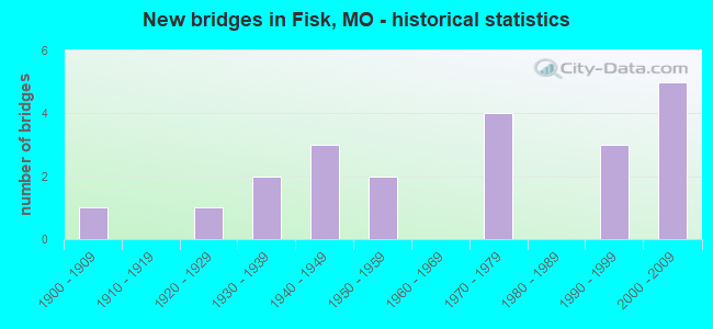
- New bridges - historical statistics
- 11900-1909
- 11920-1929
- 21930-1939
- 31940-1949
- 21950-1959
- 41970-1979
- 31990-1999
- 52000-2009


- Bridge Condition - Deck
- 7.1%Very good
- 42.9%Good
- 35.7%Satisfactory
- 14.3%Fair

- Bridge Condition - Superstructure
- 7.1%Excellent
- 21.4%Very good
- 21.4%Good
- 42.9%Satisfactory
- 7.1%Fair

- Bridge Condition - Substructure
- 21.4%Very good
- 28.6%Good
- 28.6%Satisfactory
- 7.1%Fair
- 14.3%Poor

- Bridge Condition - Channel
- 5.6%Excellent
- 27.8%Good
- 27.8%Satisfactory
- 38.9%Fair
Find on map >> Show street view
Structure Number: 12117, Location: S 8 T 24 N R 8 E (Lat: 36.735903, Lng: -90.209372), Route carried "on" structure: State highway FF, Year Built: 2001, Status: Open, Structure Length: 1.05m (3.44ft), Average Daily Traffic: 776 (year 2021), Truck Traffic: 8%, Average Future Daily Traffic: 1,164 (year 2041), Design Load: HS 20, Features Intersected: INTER RIVR DRAIN D
Minimum Vertical Clearance: 30+ m (98+ ft), Kilometerpoint: 4.981, Lanes on structure: 2, Owner: State Highway Agency, Approaching Roadway Width: 7.0m (23.0ft), Skew: 4 degrees, Material/Design: Concrete continuous, Design/Construction: Culvert, Number Of Spans In Main Unit: 2, Length of Maximum Span: 3.6m (11.8ft)
Condition: Channel: Fair, Culverts: Satisfactory, Inventory Rating: 84.6 metric tons, Method Used To Determine Inventory Rating: Load Factor (LF), Structural Evaluation: Equal to present minimum criteria, Waterway Adequacy: Superior to present desirable criteria, Approach Roadway Alignment: Equal to present desirable criteria, Designated Inspection Frequency: Every 24 months, Inspection Date: December 2020
Find on map >> Show street view
Structure Number: 15815, Location: S 9 T 24 N R 8 E (Lat: 36.733339, Lng: -90.209189), Route carried "on" structure: County highway 628, Year Built: 1900, Status: Open, Structure Length: 1.37m (4.49ft), Average Daily Traffic: 50 (year 2021), Truck Traffic: 15%, Average Future Daily Traffic: 68 (year 2041), Features Intersected: STREAM
Minimum Vertical Clearance: 30+ m (98+ ft), Kilometerpoint: 0.161, Lanes on structure: 2, Owner: County Highway Agency, Approaching Roadway Width: 6.1m (20.0ft), Material/Design: Steel, Design/Construction: Stringer/Multi-beam, Number Of Spans In Main Unit: 1, Length of Maximum Span: 13.7m (44.9ft), Curb-To-Curb Width: 6.1m (20.0ft), Out-to-Out Width: 6.4m (21.0ft)
Condition: Deck: Fair, Superstructure: Satisfactory, Substructure: Poor, Channel: Good, Operating Rating: 36.0 metric tons, Method Used To Determine Operating Rating: Allowable Stress (AS), Inventory Rating: 21.6 metric tons, Method Used To Determine Inventory Rating: Allowable Stress (AS), Structural Evaluation: Meets minimum limits, Deck Geometry: Somewhat better than minimum adequacy, Waterway Adequacy: Superior to present desirable criteria, Approach Roadway Alignment: Equal to present desirable criteria, Length Of Structure Improvement: 0.20m (0.66ft), Designated Inspection Frequency: Every 24 months, Inspection Date: November 2021, Bridge Improvement Cost: $100,000, Roadway Improvement Cost: $10,000, Total Project Cost: $149,000 ( Estimate for 2022), Deck Structure Type: Concrete Cast-file-Place
Find on map >> Show street view
Structure Number: 21868, Location: S 35 T 25 N R 8 E (Lat: 36.761664, Lng: -90.166356), Route carried "on" structure: County highway 328, Year Built: 1995, Status: Open, Structure Length: 5.79m (19.00ft), Average Daily Traffic: 50 (year 2021), Truck Traffic: 10%, Average Future Daily Traffic: 65 (year 2041), Design Load: HS 20, Features Intersected: MINGO DRAIN DTCH, Facility Carried by Structure: COUNTY RD 697
Minimum Vertical Clearance: 30+ m (98+ ft), Kilometerpoint: 0.016, Lanes on structure: 2, Owner: County Highway Agency, Approaching Roadway Width: 7.3m (24.0ft), Skew: 1 degrees, Material/Design: Prestressed concrete, Design/Construction: Stringer/Multi-beam, Number Of Spans In Main Unit: 3, Length of Maximum Span: 21.3m (69.9ft), Curb-To-Curb Width: 7.3m (24.0ft), Out-to-Out Width: 7.3m (24.0ft)
Condition: Deck: Very good, Superstructure: Excellent, Substructure: Good, Channel: Excellent, Operating Rating: 78.3 metric tons, Method Used To Determine Operating Rating: Load Factor (LF), Inventory Rating: 39.6 metric tons, Method Used To Determine Inventory Rating: Load Factor (LF), Structural Evaluation: Better than present minimum criteria, Deck Geometry: Equal to present minimum criteria, Waterway Adequacy: Superior to present desirable criteria, Approach Roadway Alignment: High priority of corrective action, Designated Inspection Frequency: Every 24 months, Inspection Date: January 2021, Deck Structure Type: Concrete Cast-file-Place
Find on map >> Show street view
Structure Number: 24929, Location: S 27 T 25 N R 8 E (Lat: 36.785531, Lng: -90.175089), Route carried "on" structure: County highway 581, Year Built: 1935, Status: Open, Structure Length: 1.43m (4.69ft), Average Daily Traffic: 35 (year 2021), Truck Traffic: 10%, Average Future Daily Traffic: 46 (year 2041), Design Load: H 15, Features Intersected: DRAIN DTCH, Facility Carried by Structure: OLD ROUTE 60
Minimum Vertical Clearance: 30+ m (98+ ft), Kilometerpoint: 0.966, Lanes on structure: 2, Owner: County Highway Agency, Approaching Roadway Width: 10.4m (34.1ft), Material/Design: Steel, Design/Construction: Stringer/Multi-beam, Number Of Spans In Main Unit: 1, Length of Maximum Span: 13.4m (44.0ft), Curb-To-Curb Width: 9.1m (29.9ft), Out-to-Out Width: 10.3m (33.8ft)
Condition: Deck: Good, Superstructure: Good, Substructure: Good, Channel: Satisfactory, Operating Rating: 36.9 metric tons, Method Used To Determine Operating Rating: Allowable Stress (AS), Inventory Rating: 23.4 metric tons, Method Used To Determine Inventory Rating: Allowable Stress (AS), Structural Evaluation: Equal to present minimum criteria, Deck Geometry: Better than present minimum criteria, Waterway Adequacy: Equal to present minimum criteria, Approach Roadway Alignment: Somewhat better than minimum adequacy, Designated Inspection Frequency: Every 24 months, Inspection Date: January 2021, Deck Structure Type: Concrete Cast-file-Place, Wearing Surface/Protective System: Wearing Surface: Monolithic Concrete
Find on map >> Show street view
Structure Number: 3082, Location: S 26 T 25 N R 7 E (Lat: 36.791292, Lng: -90.263339), Route carried "on" structure: US 60, Year Built: 1978, Year Reconstructed: 1996, Status: Open, Structure Length: 0.97m (3.18ft), Average Daily Traffic: 6,831 (year 2021), Truck Traffic: 17%, Average Future Daily Traffic: 11,954 (year 2041), Design Load: HS 20, Features Intersected: DRAIN DTCH NO 10
Minimum Vertical Clearance: 30+ m (98+ ft), Kilometerpoint: 443.299, Lanes on structure: 2, Base Highway Network: Yes, Owner: State Highway Agency, Approaching Roadway Width: 12.2m (40.0ft), Material/Design: Concrete continuous, Design/Construction: Culvert, Number Of Spans In Main Unit: 3, Length of Maximum Span: 3.0m (9.8ft)
Condition: Channel: Good, Culverts: Satisfactory, Operating Rating: 67.5 metric tons, Method Used To Determine Operating Rating: Load Factor (LF), Inventory Rating: 40.5 metric tons, Method Used To Determine Inventory Rating: Load Factor (LF), Structural Evaluation: Equal to present minimum criteria, Waterway Adequacy: Equal to present desirable criteria, Approach Roadway Alignment: Equal to present desirable criteria, Designated Inspection Frequency: Every 24 months, Inspection Date: December 2020
Find on map >> Show street view
Structure Number: 3083, Location: S 26 T 25 N R 7 E (Lat: 36.791550, Lng: -90.263933), Route carried "on" structure: US 60, Year Built: 1978, Year Reconstructed: 1996, Status: Open, Structure Length: 1.18m (3.87ft), Average Daily Traffic: 6,967 (year 2021), Truck Traffic: 19%, Average Future Daily Traffic: 12,192 (year 2041), Design Load: HS 20, Features Intersected: DRAIN DTCH NO 10
Minimum Vertical Clearance: 30+ m (98+ ft), Kilometerpoint: 105.950, Lanes on structure: 2, Base Highway Network: Yes, Owner: State Highway Agency, Approaching Roadway Width: 12.2m (40.0ft), Skew: 3 degrees, Material/Design: Concrete continuous, Design/Construction: Culvert, Number Of Spans In Main Unit: 3, Length of Maximum Span: 3.0m (9.8ft)
Condition: Channel: Good, Culverts: Satisfactory, Operating Rating: 54.9 metric tons, Method Used To Determine Operating Rating: Load Factor (LF), Inventory Rating: 33.3 metric tons, Method Used To Determine Inventory Rating: Load Factor (LF), Structural Evaluation: Equal to present minimum criteria, Waterway Adequacy: Equal to present desirable criteria, Approach Roadway Alignment: Equal to present desirable criteria, Designated Inspection Frequency: Every 24 months, Inspection Date: December 2020
Find on map >> Show street view
Structure Number: 3084, Location: S 30 T 25 N R 8 E (Lat: 36.790517, Lng: -90.244108), Route carried "on" structure: US 60, Year Built: 1978, Year Reconstructed: 1996, Status: Open, Structure Length: 0.97m (3.18ft), Average Daily Traffic: 6,831 (year 2021), Truck Traffic: 17%, Average Future Daily Traffic: 11,954 (year 2041), Design Load: HS 20, Features Intersected: DRAIN DTCH NO 11
Minimum Vertical Clearance: 30+ m (98+ ft), Kilometerpoint: 445.018, Lanes on structure: 2, Base Highway Network: Yes, Owner: State Highway Agency, Approaching Roadway Width: 12.2m (40.0ft), Material/Design: Concrete continuous, Design/Construction: Culvert, Number Of Spans In Main Unit: 3, Length of Maximum Span: 3.0m (9.8ft)
Condition: Channel: Good, Culverts: Satisfactory, Operating Rating: 61.2 metric tons, Method Used To Determine Operating Rating: Load Factor (LF), Inventory Rating: 36.9 metric tons, Method Used To Determine Inventory Rating: Load Factor (LF), Structural Evaluation: Equal to present minimum criteria, Waterway Adequacy: Equal to present desirable criteria, Approach Roadway Alignment: Equal to present desirable criteria, Designated Inspection Frequency: Every 24 months, Inspection Date: December 2020
Find on map >> Show street view
Structure Number: 31134, Location: S 22 T 25 N R 8 E (Lat: 36.797475, Lng: -90.190728), Route carried "on" structure: State highway 51, Year Built: 2005, Status: Open, Structure Length: 10.22m (33.53ft), Average Daily Traffic: 2,186 (year 2021), Truck Traffic: 26%, Average Future Daily Traffic: 3,060 (year 2041), Design Load: HS 20, Features Intersected: MINGO DTCH
Minimum Vertical Clearance: 30+ m (98+ ft), Kilometerpoint: 152.371, Lanes on structure: 2, Owner: State Highway Agency, Approaching Roadway Width: 12.2m (40.0ft), Skew: 5 degrees, Material/Design: Steel continuous, Design/Construction: Stringer/Multi-beam, Number Of Spans In Main Unit: 5, Length of Maximum Span: 22.9m (75.1ft), Curb-To-Curb Width: 12.2m (40.0ft), Out-to-Out Width: 13.0m (42.7ft)
Condition: Deck: Good, Superstructure: Very good, Substructure: Very good, Channel: Satisfactory, Operating Rating: 66.6 metric tons, Method Used To Determine Operating Rating: Load Factor (LF), Inventory Rating: 39.6 metric tons, Method Used To Determine Inventory Rating: Load Factor (LF), Structural Evaluation: Equal to present desirable criteria, Deck Geometry: Equal to present minimum criteria, Waterway Adequacy: Superior to present desirable criteria, Approach Roadway Alignment: Equal to present desirable criteria, Designated Inspection Frequency: Every 24 months, Inspection Date: October 2021, Deck Structure Type: Concrete Cast-file-Place, Wearing Surface/Protective System: Wearing Surface: Monolithic Concrete, Deck Protection: Epoxy Coated Reinforcing
Find on map >> Show street view
Structure Number: 3152, Location: S 27 T 25 N R 8 E (Lat: 36.783894, Lng: -90.187694), Route carried "on" structure: US 60, Year Built: 1978, Status: Open, Structure Length: 6.19m (20.31ft), Average Daily Traffic: 5,492 (year 2021), Truck Traffic: 21%, Average Future Daily Traffic: 9,611 (year 2041), Design Load: HS 20+Mod, Features Intersected: MINGO DTCH
Minimum Vertical Clearance: 30+ m (98+ ft), Kilometerpoint: 450.287, Lanes on structure: 2, Base Highway Network: Yes, Owner: State Highway Agency, Approaching Roadway Width: 12.2m (40.0ft), Skew: 2 degrees, Material/Design: Concrete continuous, Design/Construction: Slab, Number Of Spans In Main Unit: 5, Length of Maximum Span: 13.7m (44.9ft), Curb or Sidewalk Widths: Left: 0.2m (0.7ft), Right: 0.2m (0.7ft), Curb-To-Curb Width: 12.0m (39.4ft), Out-to-Out Width: 13.0m (42.7ft)
Condition: Deck: Good, Superstructure: Good, Substructure: Satisfactory, Channel: Fair, Operating Rating: 76.5 metric tons, Method Used To Determine Operating Rating: Load Factor (LF), Inventory Rating: 45.9 metric tons, Method Used To Determine Inventory Rating: Load Factor (LF), Structural Evaluation: Equal to present minimum criteria, Deck Geometry: Better than present minimum criteria, Waterway Adequacy: Equal to present desirable criteria, Approach Roadway Alignment: Better than present minimum criteria, Designated Inspection Frequency: Every 24 months, Inspection Date: October 2021, Deck Structure Type: Concrete Cast-file-Place, Wearing Surface/Protective System: Wearing Surface: Low Slump Concrete, Membrane: Built-up
Find on map >> Show street view
Structure Number: 3153, Location: S 27 T 25 N R 8 E (Lat: 36.784164, Lng: -90.187731), Route carried "on" structure: US 60, Year Built: 1993, Status: Open, Structure Length: 6.31m (20.70ft), Average Daily Traffic: 5,717 (year 2021), Truck Traffic: 29%, Average Future Daily Traffic: 10,005 (year 2041), Design Load: HS 25 or greater, Features Intersected: MINGO DTCH
Minimum Vertical Clearance: 30+ m (98+ ft), Kilometerpoint: 98.865, Lanes on structure: 2, Base Highway Network: Yes, Owner: State Highway Agency, Approaching Roadway Width: 12.2m (40.0ft), Skew: 2 degrees, Material/Design: Prestressed concrete continuous, Design/Construction: Stringer/Multi-beam, Number Of Spans In Main Unit: 3, Length of Maximum Span: 21.2m (69.6ft), Curb or Sidewalk Widths: Left: 0.2m (0.7ft), Right: 0.2m (0.7ft), Curb-To-Curb Width: 11.8m (38.7ft), Out-to-Out Width: 12.6m (41.3ft)
Condition: Deck: Good, Superstructure: Very good, Substructure: Very good, Channel: Satisfactory, Operating Rating: 90.0 metric tons, Method Used To Determine Operating Rating: Load Factor (LF), Inventory Rating: 50.4 metric tons, Method Used To Determine Inventory Rating: Load Factor (LF), Structural Evaluation: Equal to present desirable criteria, Deck Geometry: Better than present minimum criteria, Waterway Adequacy: Superior to present desirable criteria, Approach Roadway Alignment: Equal to present desirable criteria, Designated Inspection Frequency: Every 24 months, Inspection Date: October 2021, Deck Structure Type: Concrete Cast-file-Place, Wearing Surface/Protective System: Wearing Surface: Monolithic Concrete, Deck Protection: Epoxy Coated Reinforcing
Find on map >> Show street view
Structure Number: 32197, Location: S 28 T 25 N R 8 E (Lat: 36.787939, Lng: -90.193258), Route carried "on" structure: State highway 51, Year Built: 2008, Status: Open, Structure Length: 8.05m (26.41ft), Average Daily Traffic: 1,844 (year 2021), Truck Traffic: 26%, Average Future Daily Traffic: 2,582 (year 2041), Features Intersected: US 60
Minimum Vertical Clearance: 30+ m (98+ ft), Kilometerpoint: 153.487, Lanes on structure: 2, Lanes under structure: 4, Owner: State Highway Agency, Approaching Roadway Width: 11.6m (38.1ft), Skew: 1 degrees, Material/Design: Prestressed concrete continuous, Design/Construction: Stringer/Multi-beam, Number Of Spans In Main Unit: 4, Length of Maximum Span: 23.2m (76.1ft), Curb-To-Curb Width: 11.6m (38.1ft), Out-to-Out Width: 12.4m (40.7ft)
Condition: Deck: Good, Superstructure: Very good, Substructure: Very good, Operating Rating: 82.8 metric tons, Method Used To Determine Operating Rating: Load Factor (LF), Inventory Rating: 49.5 metric tons, Method Used To Determine Inventory Rating: Load Factor (LF), Structural Evaluation: Equal to present desirable criteria, Deck Geometry: Equal to present minimum criteria, Underclear: Meets minimum limits, Approach Roadway Alignment: Equal to present desirable criteria, Designated Inspection Frequency: Every 24 months, Inspection Date: October 2021, Deck Structure Type: Concrete Cast-file-Place, Wearing Surface/Protective System: Wearing Surface: Monolithic Concrete, Deck Protection: Epoxy Coated Reinforcing
Find on map >> Show street view
Structure Number: 4186, Location: S 25 T 25 N R 8 E (Lat: 36.788206, Lng: -90.150397), Route carried "on" structure: ServiceState highway 60, Year Built: 1993, Status: Open, Structure Length: 1.47m (4.82ft), Average Daily Traffic: 338 (year 2021), Truck Traffic: 12%, Average Future Daily Traffic: 473 (year 2041), Design Load: HS 20, Features Intersected: PRARIE CR DTCH
Minimum Vertical Clearance: 30+ m (98+ ft), Kilometerpoint: 4.324, Lanes on structure: 2, Owner: State Highway Agency, Approaching Roadway Width: 6.1m (20.0ft), Skew: 2 degrees, Material/Design: Concrete continuous, Design/Construction: Culvert, Number Of Spans In Main Unit: 3, Length of Maximum Span: 4.3m (14.1ft)
Condition: Channel: Good, Culverts: Satisfactory, Inventory Rating: 65.7 metric tons, Method Used To Determine Inventory Rating: Load Factor (LF), Structural Evaluation: Equal to present minimum criteria, Waterway Adequacy: Superior to present desirable criteria, Approach Roadway Alignment: Equal to present desirable criteria, Designated Inspection Frequency: Every 24 months, Inspection Date: October 2021
Find on map >> Show street view
Structure Number: 4581, Location: S 35 T 25 N R 7 E (Lat: 36.771244, Lng: -90.263167), Route carried "on" structure: State highway B, Year Built: 1939, Status: Open, Structure Length: 1.31m (4.30ft), Average Daily Traffic: 1,963 (year 2021), Truck Traffic: 3%, Average Future Daily Traffic: 2,945 (year 2041), Design Load: H 15, Features Intersected: DRAIN DTCH NO 12
Minimum Vertical Clearance: 30+ m (98+ ft), Kilometerpoint: 9.827, Lanes on structure: 2, Owner: State Highway Agency, Approaching Roadway Width: 7.3m (24.0ft), Skew: 1 degrees, Material/Design: Concrete, Design/Construction: Slab, Number Of Spans In Main Unit: 3, Length of Maximum Span: 4.4m (14.4ft), Curb or Sidewalk Widths: Left: 0.2m (0.7ft), Right: 0.2m (0.7ft), Curb-To-Curb Width: 7.9m (25.9ft), Out-to-Out Width: 9.0m (29.5ft)
Condition: Deck: Satisfactory, Superstructure: Satisfactory, Substructure: Satisfactory, Channel: Fair, Operating Rating: 37.8 metric tons, Method Used To Determine Operating Rating: Load Factor (LF), Inventory Rating: 16.2 metric tons, Method Used To Determine Inventory Rating: Load Factor (LF), Structural Evaluation: Meets minimum limits, Deck Geometry: Meets minimum limits, Waterway Adequacy: Equal to present desirable criteria, Approach Roadway Alignment: Equal to present desirable criteria, Designated Inspection Frequency: Every 24 months, Inspection Date: Febuary 2021, Deck Structure Type: Concrete Cast-file-Place, Wearing Surface/Protective System: Wearing Surface: Bituminous, Membrane: Built-up
Find on map >> Show street view
Structure Number: 4582, Location: S 25 T 25 N R 7 E (Lat: 36.774400, Lng: -90.242094), Route carried "on" structure: State highway 51, Year Built: 1940, Status: Open, Structure Length: 1.53m (5.02ft), Average Daily Traffic: 2,153 (year 2021), Truck Traffic: 13%, Average Future Daily Traffic: 3,230 (year 2041), Design Load: H 15, Features Intersected: DRAIN DTCH NO 11
Minimum Vertical Clearance: 30+ m (98+ ft), Kilometerpoint: 158.377, Lanes on structure: 2, Owner: State Highway Agency, Approaching Roadway Width: 7.3m (24.0ft), Skew: 1 degrees, Material/Design: Steel, Design/Construction: Stringer/Multi-beam, Number Of Spans In Main Unit: 1, Length of Maximum Span: 15.2m (49.9ft), Curb-To-Curb Width: 7.9m (25.9ft), Out-to-Out Width: 8.5m (27.9ft)
Condition: Deck: Good, Superstructure: Good, Substructure: Good, Channel: Fair, Operating Rating: 36.9 metric tons, Method Used To Determine Operating Rating: Load Factor (LF), Inventory Rating: 22.5 metric tons, Method Used To Determine Inventory Rating: Load Factor (LF), Structural Evaluation: Equal to present minimum criteria, Deck Geometry: High priority of corrective action, Waterway Adequacy: Equal to present desirable criteria, Approach Roadway Alignment: Equal to present desirable criteria, Length Of Structure Improvement: 0.22m (0.72ft), Designated Inspection Frequency: Every 24 months, Inspection Date: Febuary 2021, Bridge Improvement Cost: $188,000, Roadway Improvement Cost: $19,000, Total Project Cost: $282,000 ( Estimate for 2022), Deck Structure Type: Concrete Cast-file-Place, Wearing Surface/Protective System: Wearing Surface: Bituminous, Membrane: Built-up
Find on map >> Show street view
Structure Number: 4585, Location: S 29 T 25 N R 8 E (Lat: 36.776644, Lng: -90.227097), Route carried "on" structure: State highway 51, Year Built: 1940, Status: Open, Structure Length: 1.31m (4.30ft), Average Daily Traffic: 2,153 (year 2021), Truck Traffic: 13%, Average Future Daily Traffic: 3,230 (year 2041), Design Load: H 15, Features Intersected: DRAIN DTCH NO 16
Minimum Vertical Clearance: 30+ m (98+ ft), Kilometerpoint: 157.042, Lanes on structure: 2, Owner: State Highway Agency, Approaching Roadway Width: 7.3m (24.0ft), Skew: 1 degrees, Material/Design: Concrete, Design/Construction: Slab, Number Of Spans In Main Unit: 3, Length of Maximum Span: 4.4m (14.4ft), Curb-To-Curb Width: 7.9m (25.9ft), Out-to-Out Width: 9.0m (29.5ft)
Condition: Deck: Satisfactory, Superstructure: Satisfactory, Substructure: Satisfactory, Channel: Fair, Operating Rating: 40.5 metric tons, Method Used To Determine Operating Rating: Load Factor (LF), Inventory Rating: 24.3 metric tons, Method Used To Determine Inventory Rating: Load Factor (LF), Structural Evaluation: Equal to present minimum criteria, Deck Geometry: High priority of corrective action, Waterway Adequacy: Equal to present desirable criteria, Approach Roadway Alignment: Equal to present desirable criteria, Length Of Structure Improvement: 0.20m (0.66ft), Designated Inspection Frequency: Every 24 months, Inspection Date: Febuary 2021, Bridge Improvement Cost: $172,000, Roadway Improvement Cost: $17,000, Total Project Cost: $258,000 ( Estimate for 2022), Deck Structure Type: Concrete Cast-file-Place, Wearing Surface/Protective System: Wearing Surface: Bituminous, Membrane: Built-up
Find on map >> Show street view
Structure Number: 4586, Location: S 29 T 25 N R 8 E (Lat: 36.778672, Lng: -90.213636), Route carried "on" structure: State highway 51, Year Built: 1940, Status: Open, Structure Length: 1.49m (4.89ft), Average Daily Traffic: 1,986 (year 2021), Truck Traffic: 13%, Average Future Daily Traffic: 2,979 (year 2041), Design Load: H 15, Features Intersected: DRAIN DTCH NO 17
Minimum Vertical Clearance: 30+ m (98+ ft), Kilometerpoint: 155.793, Lanes on structure: 2, Owner: State Highway Agency, Approaching Roadway Width: 7.3m (24.0ft), Skew: 1 degrees, Material/Design: Concrete, Design/Construction: Slab, Number Of Spans In Main Unit: 3, Length of Maximum Span: 5.0m (16.4ft), Curb-To-Curb Width: 7.9m (25.9ft), Out-to-Out Width: 9.0m (29.5ft)
Condition: Deck: Satisfactory, Superstructure: Satisfactory, Substructure: Fair, Channel: Fair, Operating Rating: 37.8 metric tons, Method Used To Determine Operating Rating: Load Factor (LF), Inventory Rating: 23.4 metric tons, Method Used To Determine Inventory Rating: Load Factor (LF), Structural Evaluation: Somewhat better than minimum adequacy, Deck Geometry: Meets minimum limits, Waterway Adequacy: Equal to present desirable criteria, Approach Roadway Alignment: Equal to present desirable criteria, Designated Inspection Frequency: Every 24 months, Inspection Date: Febuary 2021, Deck Structure Type: Concrete Cast-file-Place, Wearing Surface/Protective System: Wearing Surface: Bituminous, Membrane: Built-up
Find on map >> Show street view
Structure Number: 4661, Location: S 27 T 25 N R 8 E (Lat: 36.782528, Lng: -90.187414), Route carried "on" structure: ServiceState highway 60, Year Built: 1950, Status: Open, Structure Length: 5.39m (17.68ft), Average Daily Traffic: 338 (year 2021), Truck Traffic: 12%, Average Future Daily Traffic: 473 (year 2041), Design Load: H 20, Features Intersected: MINGO DRAIN DTCH #
Minimum Vertical Clearance: 30+ m (98+ ft), Kilometerpoint: 5.203, Lanes on structure: 2, Owner: State Highway Agency, Approaching Roadway Width: 7.3m (24.0ft), Skew: 1 degrees, Material/Design: Steel, Design/Construction: Stringer/Multi-beam, Number Of Spans In Main Unit: 5, Length of Maximum Span: 20.2m (66.3ft), Curb-To-Curb Width: 8.5m (27.9ft), Out-to-Out Width: 9.7m (31.8ft)
Condition: Deck: Satisfactory, Superstructure: Satisfactory, Substructure: Good, Channel: Satisfactory, Operating Rating: 31.5 metric tons, Method Used To Determine Operating Rating: Allowable Stress (AS), Inventory Rating: 17.1 metric tons, Method Used To Determine Inventory Rating: Allowable Stress (AS), Structural Evaluation: Somewhat better than minimum adequacy, Deck Geometry: Equal to present minimum criteria, Waterway Adequacy: Equal to present desirable criteria, Approach Roadway Alignment: Equal to present minimum criteria, Designated Inspection Frequency: Every 24 months, Inspection Date: October 2021, Deck Structure Type: Concrete Cast-file-Place, Wearing Surface/Protective System: Wearing Surface: Bituminous
Find on map >> Show street view
Structure Number: 5246, Location: S 28 T 25 N R 8 E (Lat: 36.780392, Lng: -90.201644), Route carried "on" structure: State highway 51, Year Built: 1929, Status: Open, Structure Length: 10.09m (33.10ft), Average Daily Traffic: 1,646 (year 2021), Truck Traffic: 13%, Average Future Daily Traffic: 2,304 (year 2041), Design Load: H 15, Features Intersected: ST FRANCIS RVR
Minimum Vertical Clearance: 30+ m (98+ ft), Kilometerpoint: 154.645, Lanes on structure: 2, Owner: State Highway Agency, Approaching Roadway Width: 7.3m (24.0ft), Skew: 4 degrees, Material/Design: Steel, Design/Construction: Stringer/Multi-beam, Number Of Spans In Main Unit: 3, Number Of Approach Spans: 5, Length of Maximum Span: 18.5m (60.7ft), Curb-To-Curb Width: 6.4m (21.0ft), Out-to-Out Width: 6.4m (21.0ft)
Condition: Deck: Fair, Superstructure: Fair, Substructure: Poor, Channel: Satisfactory, Operating Rating: 39.6 metric tons, Method Used To Determine Operating Rating: Load Factor (LF), Inventory Rating: 23.4 metric tons, Method Used To Determine Inventory Rating: Load Factor (LF), Structural Evaluation: Meets minimum limits, Deck Geometry: High priority of replacement, Waterway Adequacy: Equal to present desirable criteria, Approach Roadway Alignment: Equal to present minimum criteria, Length Of Structure Improvement: 1.10m (3.61ft), Designated Inspection Frequency: Every 24 months, Underwater Inspection Frequency: Every 60 months, Inspection Date: January 2021, Underwater Inspection Date: June 2018, Bridge Improvement Cost: $1,256,000, Roadway Improvement Cost: $126,000, Total Project Cost: $1,884,000 ( Estimate for 2022), Deck Structure Type: Concrete Cast-file-Place, Wearing Surface/Protective System: Wearing Surface: Bituminous
Find on map >> Show street view
Structure Number: 6681, Location: S 25 T 25 N R 8 E (Lat: 36.788525, Lng: -90.149911), Route carried "on" structure: US 60, Year Built: 1956, Status: Open, Structure Length: 3.05m (10.01ft), Average Daily Traffic: 5,492 (year 2021), Truck Traffic: 21%, Average Future Daily Traffic: 9,611 (year 2041), Design Load: H 20, Features Intersected: PRARIE CR DTCH
Minimum Vertical Clearance: 30+ m (98+ ft), Kilometerpoint: 453.736, Lanes on structure: 2, Base Highway Network: Yes, Owner: State Highway Agency, Approaching Roadway Width: 7.3m (24.0ft), Skew: 2 degrees, Material/Design: Concrete continuous, Design/Construction: Slab, Number Of Spans In Main Unit: 3, Length of Maximum Span: 10.3m (33.8ft), Curb-To-Curb Width: 9.5m (31.2ft), Out-to-Out Width: 9.7m (31.8ft)
Condition: Deck: Satisfactory, Superstructure: Satisfactory, Substructure: Satisfactory, Channel: Fair, Operating Rating: 46.8 metric tons, Method Used To Determine Operating Rating: Load Factor (LF), Inventory Rating: 27.9 metric tons, Method Used To Determine Inventory Rating: Load Factor (LF), Structural Evaluation: Equal to present minimum criteria, Deck Geometry: Meets minimum limits, Waterway Adequacy: Equal to present desirable criteria, Approach Roadway Alignment: Equal to present desirable criteria, Designated Inspection Frequency: Every 24 months, Inspection Date: October 2021, Deck Structure Type: Concrete Cast-file-Place, Wearing Surface/Protective System: Wearing Surface: Bituminous
Find on map >> Show street view
Structure Number: 32197, Location: S 28 T 25 N R 8 E (Lat: 36.787939, Lng: -90.193258), Route carried "under" structure: US 60, Year Built: 2008, Structure Length: 0. m, Average Daily Traffic: 5,717 (year 2021), Truck Traffic: 29%, Features Intersected: US 60, Facility Carried by Structure: MO 51 S
Minimum Vertical Clearance: 5.44m (17.85ft), Kilometerpoint: 99.553, Lanes on structure: 2, Lanes under structure: 2, Material/Design: Prestressed concrete continuous, Design/Construction: Stringer/Multi-beam, Length of Maximum Span: 23.2m (76.1ft)
Find on map >> Show street view
Structure Number: 32197, Location: S 28 T 25 N R 8 E (Lat: 36.787939, Lng: -90.193258), Route carried "under" structure: US 60, Year Built: 2008, Structure Length: 0. m, Average Daily Traffic: 6,167 (year 2021), Truck Traffic: 17%, Features Intersected: US 60, Facility Carried by Structure: MO 51 S
Minimum Vertical Clearance: 5.46m (17.91ft), Kilometerpoint: 449.645, Lanes on structure: 2, Lanes under structure: 2, Material/Design: Prestressed concrete continuous, Design/Construction: Stringer/Multi-beam, Length of Maximum Span: 23.2m (76.1ft)