Bridge Statistics for Flat Rock, Michigan (MI)
Condition, Traffic, Stress, Structural Evaluation, Project Costs
- National Bridge Inventory (NBI) Statistics
- 15Number of bridges
- 115ft / 34.6mTotal length
- $4,000Total costs
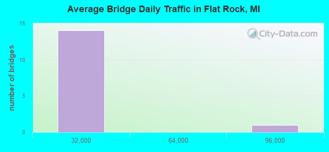
- 304,813Total average daily traffic
- 39,864Total average daily truck traffic
- National Bridge Inventory (NBI) Registered Bridges for Flat Rock
- No street view available for this location
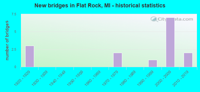
- New bridges - historical statistics
- 31920-1929
- 21970-1979
- 11990-1999
- 72000-2009
- 22010-2019
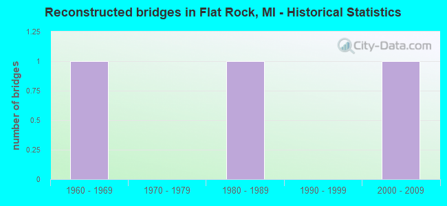
- Reconstructed bridges - Historical Statistics
- 11960-1969
- 01970-1979
- 11980-1989
- 01990-1999
- 12000-2009

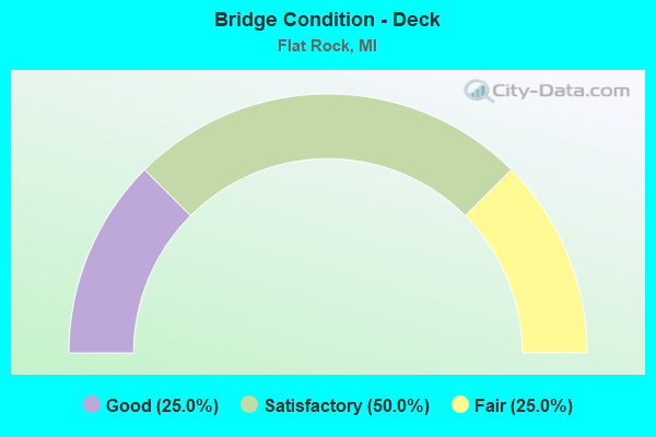
- Bridge Condition - Deck
- 25.0%Good
- 50.0%Satisfactory
- 25.0%Fair
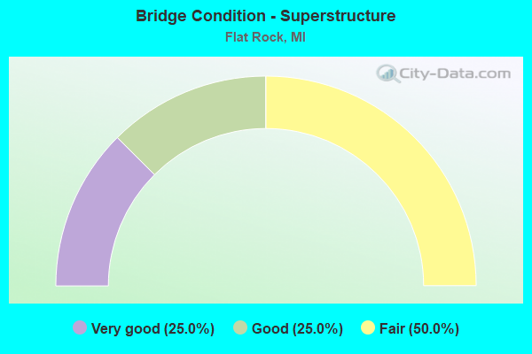
- Bridge Condition - Superstructure
- 25.0%Very good
- 25.0%Good
- 50.0%Fair
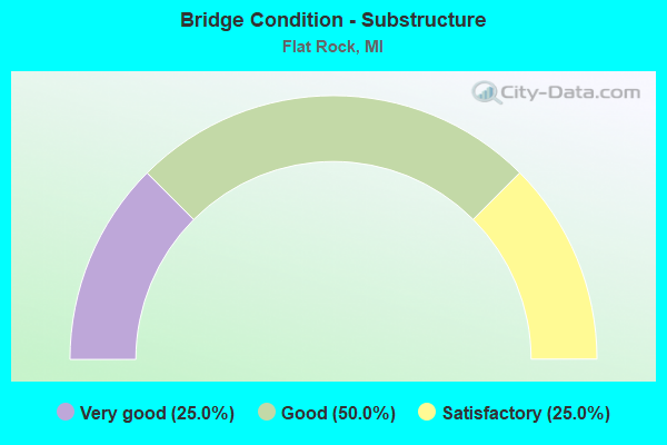
- Bridge Condition - Substructure
- 25.0%Very good
- 50.0%Good
- 25.0%Satisfactory
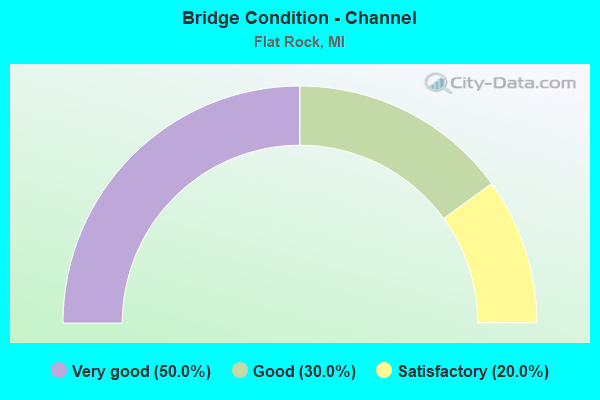
- Bridge Condition - Channel
- 50.0%Very good
- 30.0%Good
- 20.0%Satisfactory
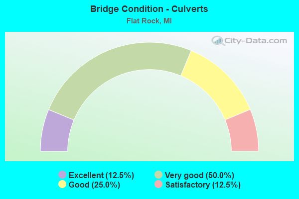
- Bridge Condition - Culverts
- 12.5%Excellent
- 50.0%Very good
- 25.0%Good
- 12.5%Satisfactory
Find on map >> Show street view
Structure Number: 7133, Location: @ WAYNE CO LINE (Lat: 42.094694, Lng: -83.294925), Route carried "on" structure: US 24, Year Built: 2001, Status: Open, Structure Length: 5.74m (18.83ft), Average Daily Traffic: 24,306 (year 2007), Truck Traffic: 1%, Average Future Daily Traffic: 31,889 (year 2018), Design Load: HS 25 or greater, Features Intersected: HURON RIVER
Minimum Vertical Clearance: 30.48m (100.00ft), Kilometerpoint: 0.000, Lanes on structure: 4, Base Highway Network: Yes (Inventory Route: 470, Subroute: 38), Owner: State Highway Agency, Approaching Roadway Width: 19.2m (63.0ft), Skew: 9 degrees, Material/Design: Prestressed concrete, Design/Construction: Box Beam or Girders - Single/Spread, Number Of Spans In Main Unit: 2, Length of Maximum Span: 28.7m (94.2ft), Curb or Sidewalk Widths: Left: 1.8m (5.9ft), Right: 1.8m (5.9ft), Curb-To-Curb Width: 19.2m (63.0ft), Out-to-Out Width: 23.4m (76.8ft)
Condition: Deck: Satisfactory, Superstructure: Fair, Substructure: Good, Channel: Good, Operating Rating: 60.1 metric tons, Method Used To Determine Operating Rating: Load Factor (LF), Inventory Rating: 36.0 metric tons, Method Used To Determine Inventory Rating: Load Factor (LF), Structural Evaluation: Somewhat better than minimum adequacy, Deck Geometry: Equal to present minimum criteria, Waterway Adequacy: Equal to present minimum criteria, Approach Roadway Alignment: Equal to present desirable criteria, Designated Inspection Frequency: Every 24 months, Inspection Date: August 2021, Deck Structure Type: Concrete Cast-file-Place, Wearing Surface/Protective System: Wearing Surface: Monolithic Concrete, Deck Protection: Epoxy Coated Reinforcing
Find on map >> Show street view
Structure Number: 11273, Location: 1.3 MI NE OF MONROE COL (Lat: 42.112333, Lng: -83.283225), Route carried "on" structure: US 24, Year Built: 2005, Status: Open, Structure Length: 0.61m (2.00ft), Average Daily Traffic: 23,486 (year 2007), Truck Traffic: 1%, Average Future Daily Traffic: 27,158 (year 2018), Design Load: HS 25 or greater, Features Intersected: SILVER CREEK
Minimum Vertical Clearance: 30.48m (100.00ft), Kilometerpoint: 2.244, Lanes on structure: 4, Base Highway Network: Yes (Inventory Route: 470, Subroute: 38), Owner: State Highway Agency, Approaching Roadway Width: 18.2m (59.7ft), Skew: 3 degrees, Material/Design: Concrete, Design/Construction: Culvert, Number Of Spans In Main Unit: 1, Length of Maximum Span: 5.5m (18.0ft), Curb-To-Curb Width: 19.5m (64.0ft), Out-to-Out Width: 42.7m (140.1ft)
Condition: Channel: Satisfactory, Culverts: Good, Operating Rating: 68.7 metric tons, Method Used To Determine Operating Rating: Load Factor (LF) rating reported by rating factor (RF) method using MS18 loading, Inventory Rating: 41.1 metric tons, Method Used To Determine Inventory Rating: Load Factor (LF) rating reported by rating factor (RF) method using MS18 loading, Structural Evaluation: Better than present minimum criteria, Deck Geometry: Better than present minimum criteria, Waterway Adequacy: Equal to present desirable criteria, Approach Roadway Alignment: Equal to present desirable criteria, Length Of Structure Improvement: 0.70m (2.30ft), Designated Inspection Frequency: Every 24 months, Inspection Date: May 2020, Bridge Improvement Cost: $9,000, Total Project Cost: $4,000, Deck Structure Type: Concrete Cast-file-Place, Wearing Surface/Protective System: Wearing Surface: Bituminous
Find on map >> Show street view
Structure Number: 11274, Location: 1.7 MI NE OF FLATROCK (Lat: 42.117606, Lng: -83.279747), Route carried "on" structure: US 24, Year Built: 2011, Status: Open, Structure Length: 0.80m (2.62ft), Average Daily Traffic: 27,700 (year 2008), Truck Traffic: 4%, Average Future Daily Traffic: 33,800 (year 2028), Design Load: Greater than HL93, Features Intersected: SMITH CREEK
Minimum Vertical Clearance: 30.48m (100.00ft), Kilometerpoint: 2.895, Lanes on structure: 5, Base Highway Network: Yes (Inventory Route: 470, Subroute: 38), Owner: State Highway Agency, Approaching Roadway Width: 17.1m (56.1ft), Material/Design: Concrete, Design/Construction: Culvert, Number Of Spans In Main Unit: 1, Length of Maximum Span: 7.3m (24.0ft), Curb-To-Curb Width: 18.9m (62.0ft), Out-to-Out Width: 33.5m (109.9ft)
Condition: Channel: Very good, Culverts: Good, Operating Rating: 41.5 metric tons, Method Used To Determine Operating Rating: Load and Resistance Factor Rating (LRFR) rating reported by rating factor(RF) method using HL-93 loadings, Inventory Rating: 32.1 metric tons, Method Used To Determine Inventory Rating: Load and Resistance Factor Rating (LRFR) rating reported by rating factor(RF) method using HL-93 loadings, Structural Evaluation: Better than present minimum criteria, Deck Geometry: Meets minimum limits, Waterway Adequacy: Equal to present minimum criteria, Approach Roadway Alignment: Equal to present minimum criteria, Designated Inspection Frequency: Every 24 months, Inspection Date: May 2020, Wearing Surface/Protective System: Wearing Surface: Bituminous
Find on map >> Show street view
Structure Number: 11632, Location: 1.5 MI N OF N HURON RI DR (Lat: 42.083011, Lng: -83.243306), Route carried "on" structure: State highway 85, Year Built: 2008, Status: Open, Structure Length: 0.68m (2.23ft), Average Daily Traffic: 2,664 (year 2007), Truck Traffic: 19%, Average Future Daily Traffic: 5,233 (year 2028), Design Load: Greater than HL93, Features Intersected: SMITH CREEK
Minimum Vertical Clearance: 30.48m (100.00ft), Kilometerpoint: 0.177, Lanes on structure: 2, Base Highway Network: Yes (Inventory Route: 159, Subroute: 6), Owner: State Highway Agency, Approaching Roadway Width: 10.9m (35.8ft), Material/Design: Concrete, Design/Construction: Culvert, Number Of Spans In Main Unit: 1, Length of Maximum Span: 6.3m (20.7ft), Out-to-Out Width: 30.3m (99.4ft)
Condition: Channel: Very good, Culverts: Very good, Operating Rating: 97.2 metric tons, Method Used To Determine Operating Rating: Load Factor (LF) rating reported by rating factor (RF) method using MS18 loading, Inventory Rating: 97.2 metric tons, Method Used To Determine Inventory Rating: Load Factor (LF) rating reported by rating factor (RF) method using MS18 loading, Structural Evaluation: Equal to present desirable criteria, Waterway Adequacy: Equal to present minimum criteria, Approach Roadway Alignment: Equal to present minimum criteria, Designated Inspection Frequency: Every 24 months, Inspection Date: July 2020, Wearing Surface/Protective System: Wearing Surface: Monolithic Concrete
Find on map >> Show street view
Structure Number: 11633, Location: 1.5 MI N OF N HURON RI DR (Lat: 42.082894, Lng: -83.242208), Route carried "on" structure: Interstate 75, Year Built: 2008, Status: Open, Structure Length: 0.67m (2.20ft), Average Daily Traffic: 28,645 (year 2007), Truck Traffic: 19%, Average Future Daily Traffic: 95,990 (year 2028), Design Load: Greater than HL93, Features Intersected: SMITH CREEK
Minimum Vertical Clearance: 30.48m (100.00ft), Kilometerpoint: 1.923, Lanes on structure: 7, Base Highway Network: Yes (Inventory Route: 159, Subroute: 10), Owner: State Highway Agency, Approaching Roadway Width: 30.4m (99.7ft), Material/Design: Concrete, Design/Construction: Culvert, Number Of Spans In Main Unit: 1, Length of Maximum Span: 6.3m (20.7ft), Out-to-Out Width: 91.1m (298.9ft)
Condition: Channel: Very good, Culverts: Very good, Operating Rating: 97.2 metric tons, Method Used To Determine Operating Rating: Load Factor (LF) rating reported by rating factor (RF) method using MS18 loading, Inventory Rating: 95.3 metric tons, Method Used To Determine Inventory Rating: Load Factor (LF) rating reported by rating factor (RF) method using MS18 loading, Structural Evaluation: Equal to present desirable criteria, Waterway Adequacy: Equal to present minimum criteria, Approach Roadway Alignment: Equal to present minimum criteria, Designated Inspection Frequency: Every 24 months, Inspection Date: July 2020, Wearing Surface/Protective System: Wearing Surface: Monolithic Concrete
Find on map >> Show street view
Structure Number: 11644, Location: @ M-85 (Lat: 42.085169, Lng: -83.241683), Route carried "on" structure: State highway 85, Year Built: 2005, Year Reconstructed: 2008, Status: Open, Structure Length: 10.47m (34.35ft), Average Daily Traffic: 5,233 (year 2007), Truck Traffic: 19%, Average Future Daily Traffic: 10,200 (year 2028), Design Load: HS 20+Mod, Features Intersected: I-75 NB
Minimum Vertical Clearance: 30.48m (100.00ft), Kilometerpoint: 0.454, Lanes on structure: 2, Lanes under structure: 3, Base Highway Network: Yes (Inventory Route: 159, Subroute: 6), Owner: State Highway Agency, Approaching Roadway Width: 13.4m (44.0ft), Skew: 3 degrees, Material/Design: Steel, Design/Construction: Stringer/Multi-beam, Number Of Spans In Main Unit: 2, Length of Maximum Span: 56.0m (183.7ft), Curb-To-Curb Width: 13.4m (44.0ft), Out-to-Out Width: 14.4m (47.2ft)
Condition: Deck: Good, Superstructure: Very good, Substructure: Very good, Operating Rating: 57.0 metric tons, Method Used To Determine Operating Rating: Load Factor (LF) rating reported by rating factor (RF) method using MS18 loading, Inventory Rating: 34.3 metric tons, Method Used To Determine Inventory Rating: Load Factor (LF) rating reported by rating factor (RF) method using MS18 loading, Structural Evaluation: Equal to present desirable criteria, Deck Geometry: Superior to present desirable criteria, Underclear: High priority of corrective action, Approach Roadway Alignment: Equal to present desirable criteria, Designated Inspection Frequency: Every 24 months, Inspection Date: July 2020, Deck Structure Type: Concrete Cast-file-Place, Wearing Surface/Protective System: Wearing Surface: Monolithic Concrete, Deck Protection: Epoxy Coated Reinforcing
Find on map >> Show street view
Structure Number: 11645, Location: 0.7 MI N OF M-85 (Lat: 42.095381, Lng: -83.241547), Route carried "on" structure: County highway 2057, Year Built: 1971, Status: Open, Structure Length: 6.93m (22.74ft), Average Daily Traffic: 16,600 (year 2010), Truck Traffic: 5%, Average Future Daily Traffic: 19,090 (year 2030), Design Load: HS 20, Features Intersected: I-75, Facility Carried by Structure: GIBRALTAR RD
Minimum Vertical Clearance: 30.48m (100.00ft), Kilometerpoint: 4.030, Lanes on structure: 4, Lanes under structure: 8, Owner: State Highway Agency, Approaching Roadway Width: 27.6m (90.6ft), Skew: 30 degrees, Material/Design: Steel, Design/Construction: Stringer/Multi-beam, Number Of Spans In Main Unit: 2, Length of Maximum Span: 35.7m (117.1ft), Curb or Sidewalk Widths: Left: 1.8m (5.9ft), Right: 0.0m, Curb-To-Curb Width: 24.4m (80.1ft), Out-to-Out Width: 28.6m (93.8ft)
Condition: Deck: Satisfactory, Superstructure: Good, Substructure: Good, Operating Rating: 68.7 metric tons, Method Used To Determine Operating Rating: Load Factor (LF) rating reported by rating factor (RF) method using MS18 loading, Inventory Rating: 41.1 metric tons, Method Used To Determine Inventory Rating: Load Factor (LF) rating reported by rating factor (RF) method using MS18 loading, Structural Evaluation: Better than present minimum criteria, Deck Geometry: Superior to present desirable criteria, Underclear: Meets minimum limits, Approach Roadway Alignment: Equal to present desirable criteria, Designated Inspection Frequency: Every 24 months, Inspection Date: July 2020, Deck Structure Type: Concrete Cast-file-Place, Wearing Surface/Protective System: Wearing Surface: Epoxy Overlay
Find on map >> Show street view
Structure Number: 11984, Location: HURON S/HURON RIVER DR. (Lat: 42.116000, Lng: -83.357100), Route carried "on" structure: County highway 8206, Year Built: 1922, Year Reconstructed: 1993, Status: Open, Structure Length: 5.85m (19.19ft), Average Daily Traffic: 7,481 (year 1997), Truck Traffic: 5%, Average Future Daily Traffic: 4,000 (year 2015), Design Load: HS 20, Features Intersected: HURON RIVER, Facility Carried by Structure: WILLOW ROAD
Minimum Vertical Clearance: 30.48m (100.00ft), Kilometerpoint: 11.206, Lanes on structure: 2, Owner: County Highway Agency, Approaching Roadway Width: 8.8m (28.9ft), Material/Design: Concrete continuous, Design/Construction: Arch - Deck, Number Of Spans In Main Unit: 2, Length of Maximum Span: 33.2m (108.9ft), Curb-To-Curb Width: 7.7m (25.3ft), Out-to-Out Width: 8.6m (28.2ft)
Condition: Deck: Fair, Superstructure: Fair, Substructure: Satisfactory, Channel: Satisfactory, Operating Rating: 97.2 metric tons, Method Used To Determine Operating Rating: Load Factor (LF) rating reported by rating factor (RF) method using MS18 loading, Inventory Rating: 58.3 metric tons, Method Used To Determine Inventory Rating: Load Factor (LF) rating reported by rating factor (RF) method using MS18 loading, Structural Evaluation: Somewhat better than minimum adequacy, Deck Geometry: High priority of replacement, Waterway Adequacy: Equal to present desirable criteria, Approach Roadway Alignment: Equal to present desirable criteria, Designated Inspection Frequency: Every 24 months, Inspection Date: June 2021
Find on map >> Show street view
Structure Number: 11991, Location: FLATROCKE/TELEGRAPH (Lat: 42.094567, Lng: -83.275097), Route carried "on" structure: County highway 2057, Year Built: 1928, Year Reconstructed: 1974, Status: Posted for load, Structure Length: 0.73m (2.40ft), Average Daily Traffic: 11,804 (year 1992), Truck Traffic: 2%, Average Future Daily Traffic: 13,575 (year 2015), Design Load: HS 20+Mod, Features Intersected: SILVER CREEK, Facility Carried by Structure: GIBRALTAR ROAD
Minimum Vertical Clearance: 30.48m (100.00ft), Kilometerpoint: 1.254, Lanes on structure: 4, Owner: County Highway Agency, Approaching Roadway Width: 14.6m (47.9ft), Skew: 4 degrees, Material/Design: Concrete, Design/Construction: Culvert, Number Of Spans In Main Unit: 1, Length of Maximum Span: 6.4m (21.0ft), Curb-To-Curb Width: 14.6m (47.9ft), Out-to-Out Width: 21.3m (69.9ft)
Condition: Channel: Good, Culverts: Satisfactory, Operating Rating: 31.8 metric tons, Method Used To Determine Operating Rating: Load Factor (LF) rating reported by rating factor (RF) method using MS18 loading, Inventory Rating: 19.1 metric tons, Method Used To Determine Inventory Rating: Load Factor (LF) rating reported by rating factor (RF) method using MS18 loading, Structural Evaluation: Meets minimum limits, Deck Geometry: High priority of replacement, Waterway Adequacy: Better than present minimum criteria, Approach Roadway Alignment: Equal to present desirable criteria, Bridge Posting: Required (Relationship of Operating Rating to Maximum Legal Load: 0.1 - 9.9% below), Designated Inspection Frequency: Every 24 months, Inspection Date: Febuary 2021, Deck Structure Type: Concrete Cast-file-Place, Wearing Surface/Protective System: Wearing Surface: Bituminous
Find on map >> Show street view
Structure Number: 12001, Location: BROWNSTOWN E/INKSTER (Lat: 42.123475, Lng: -83.294889), Route carried "on" structure: County highway 2057, Year Built: 2018, Status: Open, Structure Length: 0.72m (2.36ft), Average Daily Traffic: 8,920 (year 2017), Truck Traffic: 2%, Average Future Daily Traffic: 9,210 (year 2037), Design Load: Greater than HL93, Features Intersected: SILVER CREEK, Facility Carried by Structure: VAN HORN ROAD
Minimum Vertical Clearance: 30.48m (100.00ft), Kilometerpoint: 4.646, Lanes on structure: 2, Owner: County Highway Agency, Approaching Roadway Width: 15.2m (49.9ft), Skew: 4 degrees, Material/Design: Concrete, Design/Construction: Culvert, Number Of Spans In Main Unit: 1, Length of Maximum Span: 7.2m (23.6ft), Curb-To-Curb Width: 9.1m (29.9ft), Out-to-Out Width: 34.9m (114.5ft)
Condition: Channel: Very good, Culverts: Excellent, Operating Rating: 71.9 metric tons, Method Used To Determine Operating Rating: Load and Resistance Factor Rating (LRFR) rating reported by rating factor(RF) method using HL-93 loadings, Inventory Rating: 55.4 metric tons, Method Used To Determine Inventory Rating: Load and Resistance Factor Rating (LRFR) rating reported by rating factor(RF) method using HL-93 loadings, Structural Evaluation: Superior to present desirable criteria, Deck Geometry: High priority of corrective action, Waterway Adequacy: Equal to present desirable criteria, Approach Roadway Alignment: Equal to present desirable criteria, Designated Inspection Frequency: Every 24 months, Inspection Date: November 2020, Wearing Surface/Protective System: Wearing Surface: Low Slump Concrete
Find on map >> Show street view
Structure Number: 12008, Location: HURON W/INKSTER (Lat: 42.137714, Lng: -83.313297), Route carried "on" structure: County highway 8212, Year Built: 2001, Status: Open, Structure Length: 0.67m (2.20ft), Average Daily Traffic: 623 (year 1997), Truck Traffic: 1%, Average Future Daily Traffic: 951 (year 2015), Design Load: HS 20, Features Intersected: SILVER CREEK, Facility Carried by Structure: WEST ROAD
Minimum Vertical Clearance: 30.48m (100.00ft), Kilometerpoint: 4.130, Lanes on structure: 2, Owner: County Highway Agency, Approaching Roadway Width: 8.5m (27.9ft), Skew: 3 degrees, Material/Design: Concrete, Design/Construction: Culvert, Number Of Spans In Main Unit: 1, Length of Maximum Span: 5.7m (18.7ft), Curb or Sidewalk Widths: Left: 0.2m (0.7ft), Right: 0.2m (0.7ft), Out-to-Out Width: 26.8m (87.9ft)
Condition: Channel: Very good, Culverts: Very good, Operating Rating: 69.3 metric tons, Method Used To Determine Operating Rating: Load Factor (LF) rating reported by rating factor (RF) method using MS18 loading, Inventory Rating: 41.5 metric tons, Method Used To Determine Inventory Rating: Load Factor (LF) rating reported by rating factor (RF) method using MS18 loading, Structural Evaluation: Equal to present desirable criteria, Waterway Adequacy: Superior to present desirable criteria, Approach Roadway Alignment: Equal to present desirable criteria, Designated Inspection Frequency: Every 24 months, Inspection Date: June 2021, Deck Structure Type: Concrete Cast-file-Place, Wearing Surface/Protective System: Wearing Surface: Monolithic Concrete
Find on map >> Show street view
Structure Number: 12164, Location: BROWNSTOWN/HURON S/GRIX (Lat: 42.130075, Lng: -83.304608), Route carried "on" structure: County highway 2057, Year Built: 1997, Status: Open, Structure Length: 0.77m (2.53ft), Average Daily Traffic: 4,400 (year 1996), Truck Traffic: 5%, Average Future Daily Traffic: 3,610 (year 2015), Design Load: HS 25 or greater, Features Intersected: SILVER CREEK, Facility Carried by Structure: INKSTER ROAD
Minimum Vertical Clearance: 30.48m (100.00ft), Kilometerpoint: 1.535, Lanes on structure: 2, Owner: County Highway Agency, Approaching Roadway Width: 12.2m (40.0ft), Skew: 4 degrees, Material/Design: Concrete, Design/Construction: Culvert, Number Of Spans In Main Unit: 2, Length of Maximum Span: 3.3m (10.8ft), Curb-To-Curb Width: 13.4m (44.0ft), Out-to-Out Width: 123.7m (405.8ft)
Condition: Channel: Good, Culverts: Very good, Operating Rating: 63.2 metric tons, Method Used To Determine Operating Rating: Load Factor (LF) rating reported by rating factor (RF) method using MS18 loading, Inventory Rating: 37.9 metric tons, Method Used To Determine Inventory Rating: Load Factor (LF) rating reported by rating factor (RF) method using MS18 loading, Structural Evaluation: Equal to present desirable criteria, Deck Geometry: Better than present minimum criteria, Waterway Adequacy: Equal to present desirable criteria, Approach Roadway Alignment: Equal to present desirable criteria, Designated Inspection Frequency: Every 24 months, Inspection Date: May 2021
Find on map >> Show street view
Structure Number: 11275, Location: IN FLAT ROCK (Lat: 42.102317, Lng: -83.289767), Route carried "under" structure: US 24, Year Built: 1926, Structure Length: 0. m, Average Daily Traffic: 24,306 (year 2007), Truck Traffic: 2%, Features Intersected: US-24, Facility Carried by Structure: GTW RR
Minimum Vertical Clearance: 4.72m (15.49ft), Kilometerpoint: 1.006, Lanes under structure: 4, Material/Design: Steel, Design/Construction: Girder and Floorbeam System, Length of Maximum Span: 16.7m (54.8ft)
Find on map >> Show street view
Structure Number: 11644, Location: @ M-85 (Lat: 42.085169, Lng: -83.241683), Route carried "under" structure: Interstate 75, Year Built: 2005, Structure Length: 0. m, Average Daily Traffic: 28,645 (year 2007), Truck Traffic: 29%, Features Intersected: I-75 NB, Facility Carried by Structure: M-85 SB
Minimum Vertical Clearance: 4.83m (15.85ft), Kilometerpoint: 2.181, Lanes on structure: 2, Lanes under structure: 3, Material/Design: Steel, Design/Construction: Stringer/Multi-beam, Length of Maximum Span: 56.0m (183.7ft)
Find on map >> Show street view
Structure Number: 11645, Location: 0.7 MI N OF M-85 (Lat: 42.095381, Lng: -83.241547), Route carried "under" structure: Interstate 75, Year Built: 1971, Structure Length: 0. m, Average Daily Traffic: 90,000 (year 2015), Truck Traffic: 23%, Features Intersected: I-75, Facility Carried by Structure: GIBRALTAR RD
Minimum Vertical Clearance: 4.82m (15.81ft), Kilometerpoint: 3.315, Lanes on structure: 4, Lanes under structure: 8, Material/Design: Steel, Design/Construction: Stringer/Multi-beam, Length of Maximum Span: 35.7m (117.1ft)