Bridge Statistics for Flat Top Mountain, Tennessee (TN)
Condition, Traffic, Stress, Structural Evaluation, Project Costs
- National Bridge Inventory (NBI) Statistics
- 13Number of bridges
- 98ft / 30.5mTotal length
- 70,903Total average daily traffic
- 7,659Total average daily truck traffic
- National Bridge Inventory (NBI) Registered Bridges for Flat Top Mountain
- No street view available for this location
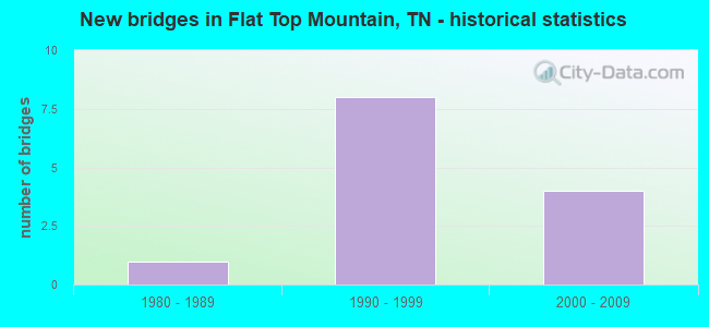
- New bridges - historical statistics
- 11980-1989
- 81990-1999
- 42000-2009


- Bridge Condition - Deck
- 50.0%Good
- 50.0%Satisfactory

- Bridge Condition - Superstructure
- 75.0%Good
- 25.0%Satisfactory

- Bridge Condition - Channel
- 50.0%Good
- 25.0%Satisfactory
- 25.0%Fair
Find on map >> Show street view
Structure Number: 40A3180001, Location: 2MI WEST OF HAMILTON CO. (Lat: 35.403819, Lng: -85.242814), Route carried "on" structure: County highway 761, Year Built: 1984, Status: Open, Structure Length: 0.70m (2.30ft), Average Daily Traffic: 100 (year 2022), Truck Traffic: 2%, Average Future Daily Traffic: 160 (year 2040), Design Load: HS 20, Features Intersected: LAUREL BRANCH
Minimum Vertical Clearance: 30+ m (98+ ft), Kilometerpoint: 4.680, Lanes on structure: 2, Owner: County Highway Agency, Approaching Roadway Width: 6.7m (22.0ft), Material/Design: Concrete continuous, Design/Construction: Culvert, Number Of Spans In Main Unit: 2, Length of Maximum Span: 3.0m (9.8ft), Curb-To-Curb Width: 6.9m (22.6ft), Out-to-Out Width: 7.8m (25.6ft)
Condition: Channel: Satisfactory, Culverts: Satisfactory, Operating Rating: 42.3 metric tons, Method Used To Determine Operating Rating: Load Factor (LF), Inventory Rating: 26.1 metric tons, Method Used To Determine Inventory Rating: Load Factor (LF), Structural Evaluation: Equal to present minimum criteria, Deck Geometry: Somewhat better than minimum adequacy, Waterway Adequacy: Better than present minimum criteria, Approach Roadway Alignment: Equal to present minimum criteria, Designated Inspection Frequency: Every 24 months, Inspection Date: July 2020, Deck Structure Type: Concrete Cast-file-Place, Wearing Surface/Protective System: Wearing Surface: Bituminous
Find on map >> Show street view
Structure Number: 33SR1110009, Location: 1.6 MI E OF SEQUAT. CO LN (Lat: 35.339300, Lng: -85.204283), Route carried "on" structure: State highway 111, Year Built: 1993, Status: Open, Structure Length: 0.67m (2.20ft), Average Daily Traffic: 10,230 (year 2020), Truck Traffic: 11%, Average Future Daily Traffic: 18,000 (year 2040), Design Load: HS 20, Features Intersected: BOARD CAMP CREEK
Minimum Vertical Clearance: 30+ m (98+ ft), Kilometerpoint: 9.270, Lanes on structure: 2, Base Highway Network: Yes, Owner: State Highway Agency, Approaching Roadway Width: 14.6m (47.9ft), Material/Design: Concrete continuous, Design/Construction: Culvert, Number Of Spans In Main Unit: 2, Length of Maximum Span: 3.0m (9.8ft)
Condition: Channel: Good, Culverts: Satisfactory, Operating Rating: 54.0 metric tons, Method Used To Determine Operating Rating: Field evaluation and documented engineering judgment, Inventory Rating: 32.4 metric tons, Method Used To Determine Inventory Rating: Field evaluation and documented engineering judgment, Structural Evaluation: Equal to present minimum criteria, Waterway Adequacy: Equal to present desirable criteria, Approach Roadway Alignment: Equal to present desirable criteria, Designated Inspection Frequency: Every 24 months, Inspection Date: Febuary 2021
Find on map >> Show street view
Structure Number: 33SR1110011, Location: 1.4 MI E OF SEQUATCHIE C0 (Lat: 35.344367, Lng: -85.183250), Route carried "on" structure: County highway 546, Year Built: 2005, Status: Open, Structure Length: 9.33m (30.61ft), Average Daily Traffic: 40 (year 2022), Truck Traffic: 1%, Average Future Daily Traffic: 64 (year 2041), Design Load: HS 20, Features Intersected: JONES GAP RD. / SR 111
Minimum Vertical Clearance: 30+ m (98+ ft), Kilometerpoint: 4.975, Lanes on structure: 2, Lanes under structure: 2, Owner: State Highway Agency, Approaching Roadway Width: 9.1m (29.9ft), Material/Design: Prestressed concrete continuous, Design/Construction: Stringer/Multi-beam, Number Of Spans In Main Unit: 4, Length of Maximum Span: 27.2m (89.2ft), Curb-To-Curb Width: 10.4m (34.1ft), Out-to-Out Width: 11.0m (36.1ft)
Condition: Deck: Good, Superstructure: Good, Substructure: Good, Operating Rating: 62.1 metric tons, Method Used To Determine Operating Rating: Load Factor (LF), Inventory Rating: 32.4 metric tons, Method Used To Determine Inventory Rating: Load Factor (LF), Structural Evaluation: Better than present minimum criteria, Deck Geometry: Superior to present desirable criteria, Underclear: Better than present minimum criteria, Approach Roadway Alignment: Equal to present desirable criteria, Designated Inspection Frequency: Every 24 months, Inspection Date: Febuary 2021, Deck Structure Type: Concrete Cast-file-Place, Wearing Surface/Protective System: Wearing Surface: Monolithic Concrete, Deck Protection: Epoxy Coated Reinforcing
Find on map >> Show street view
Structure Number: 77021680001, Location: 5 MI EAST OF SR 28 (Lat: 35.352500, Lng: -85.288500), Route carried "on" structure: County highway 2168, Year Built: 1993, Status: Open, Structure Length: 0.85m (2.79ft), Average Daily Traffic: 1,517 (year 2020), Truck Traffic: 4%, Average Future Daily Traffic: 2,427 (year 2042), Design Load: HS 20, Features Intersected: GRAY CREEK
Minimum Vertical Clearance: 30+ m (98+ ft), Kilometerpoint: 1.996, Lanes on structure: 2, Owner: County Highway Agency, Approaching Roadway Width: 10.4m (34.1ft), Skew: 2 degrees, Material/Design: Concrete continuous, Design/Construction: Culvert, Number Of Spans In Main Unit: 2, Length of Maximum Span: 4.0m (13.1ft)
Condition: Channel: Good, Culverts: Satisfactory, Operating Rating: 89.1 metric tons, Method Used To Determine Operating Rating: Load Factor (LF), Inventory Rating: 32.4 metric tons, Method Used To Determine Inventory Rating: Load Factor (LF), Structural Evaluation: Equal to present minimum criteria, Waterway Adequacy: Equal to present desirable criteria, Approach Roadway Alignment: Equal to present desirable criteria, Designated Inspection Frequency: Every 24 months, Inspection Date: Febuary 2021
Find on map >> Show street view
Structure Number: 77SR1110009, Location: 2.8 MI W OF HAMILTON CL (Lat: 35.350067, Lng: -85.280600), Route carried "on" structure: State highway 111, Year Built: 2003, Status: Open, Structure Length: 5.08m (16.67ft), Average Daily Traffic: 9,564 (year 2020), Truck Traffic: 11%, Average Future Daily Traffic: 15,302 (year 2042), Design Load: HS 20, Features Intersected: NFA A119 OLD HENSON RD
Minimum Vertical Clearance: 30+ m (98+ ft), Kilometerpoint: 4.522, Lanes on structure: 2, Lanes under structure: 2, Base Highway Network: Yes, Owner: State Highway Agency, Approaching Roadway Width: 13.4m (44.0ft), Skew: 4 degrees, Material/Design: Prestressed concrete continuous, Design/Construction: Stringer/Multi-beam, Number Of Spans In Main Unit: 3, Length of Maximum Span: 24.4m (80.1ft), Curb-To-Curb Width: 12.8m (42.0ft), Out-to-Out Width: 13.4m (44.0ft)
Condition: Deck: Good, Superstructure: Good, Substructure: Good, Operating Rating: 76.5 metric tons, Method Used To Determine Operating Rating: Load Factor (LF), Inventory Rating: 32.4 metric tons, Method Used To Determine Inventory Rating: Load Factor (LF), Structural Evaluation: Better than present minimum criteria, Deck Geometry: Equal to present desirable criteria, Underclear: Equal to present minimum criteria, Approach Roadway Alignment: Equal to present desirable criteria, Designated Inspection Frequency: Every 24 months, Inspection Date: January 2021, Deck Structure Type: Concrete Precast Panels, Wearing Surface/Protective System: Wearing Surface: Monolithic Concrete, Deck Protection: Epoxy Coated Reinforcing
Find on map >> Show street view
Structure Number: 77SR111001, Location: 2.8 MI W OF HAMILTON CL (Lat: 35.349667, Lng: -85.280083), Route carried "on" structure: State highway 111, Year Built: 1993, Status: Open, Structure Length: 5.08m (16.67ft), Average Daily Traffic: 9,564 (year 2020), Truck Traffic: 11%, Average Future Daily Traffic: 15,302 (year 2042), Design Load: HS 20, Features Intersected: NFA A119 OLD HENSON RD
Minimum Vertical Clearance: 30+ m (98+ ft), Kilometerpoint: 4.522, Lanes on structure: 2, Lanes under structure: 2, Base Highway Network: Yes, Owner: State Highway Agency, Approaching Roadway Width: 13.4m (44.0ft), Skew: 4 degrees, Material/Design: Prestressed concrete continuous, Design/Construction: Stringer/Multi-beam, Number Of Spans In Main Unit: 3, Length of Maximum Span: 24.4m (80.1ft), Curb-To-Curb Width: 14.6m (47.9ft), Out-to-Out Width: 15.2m (49.9ft)
Condition: Deck: Satisfactory, Superstructure: Good, Substructure: Good, Operating Rating: 80.1 metric tons, Method Used To Determine Operating Rating: Load Factor (LF), Inventory Rating: 32.4 metric tons, Method Used To Determine Inventory Rating: Load Factor (LF), Structural Evaluation: Better than present minimum criteria, Deck Geometry: Superior to present desirable criteria, Underclear: Superior to present desirable criteria, Approach Roadway Alignment: Equal to present desirable criteria, Designated Inspection Frequency: Every 24 months, Inspection Date: January 2021, Deck Structure Type: Concrete Precast Panels, Wearing Surface/Protective System: Wearing Surface: Monolithic Concrete, Deck Protection: Epoxy Coated Reinforcing
Find on map >> Show street view
Structure Number: 77SR1110011, Location: AT HAMILTON COUNTY LINE (Lat: 35.344967, Lng: -85.232550), Route carried "on" structure: County highway 546, Year Built: 1993, Status: Open, Structure Length: 7.41m (24.31ft), Average Daily Traffic: 200 (year 2022), Truck Traffic: 5%, Average Future Daily Traffic: 320 (year 2041), Design Load: HS 20, Features Intersected: SR 111
Minimum Vertical Clearance: 30+ m (98+ ft), Kilometerpoint: 1.738, Lanes on structure: 2, Lanes under structure: 5, Owner: State Highway Agency, Approaching Roadway Width: 9.1m (29.9ft), Skew: 1 degrees, Material/Design: Concrete continuous, Design/Construction: Box Beam or Girders - Single/Spread, Number Of Spans In Main Unit: 2, Length of Maximum Span: 38.4m (126.0ft), Curb-To-Curb Width: 9.1m (29.9ft), Out-to-Out Width: 9.8m (32.2ft)
Condition: Deck: Satisfactory, Superstructure: Satisfactory, Substructure: Good, Operating Rating: 44.1 metric tons, Method Used To Determine Operating Rating: Assigned rating based on Load Factor Design (LFD) reported in metric tons, Inventory Rating: 32.4 metric tons, Method Used To Determine Inventory Rating: Assigned rating based on Load Factor Design (LFD) reported in metric tons, Structural Evaluation: Equal to present minimum criteria, Deck Geometry: Equal to present minimum criteria, Underclear: Superior to present desirable criteria, Approach Roadway Alignment: Equal to present desirable criteria, Designated Inspection Frequency: Every 24 months, Inspection Date: January 2021, Deck Structure Type: Concrete Cast-file-Place, Wearing Surface/Protective System: Wearing Surface: Monolithic Concrete, Deck Protection: Epoxy Coated Reinforcing
Find on map >> Show street view
Structure Number: 77SR1110013, Location: 1 MI W OF HAMILTON CO LN (Lat: 35.352167, Lng: -85.252733), Route carried "on" structure: State highway 111, Year Built: 1993, Status: Open, Structure Length: 1.34m (4.40ft), Average Daily Traffic: 9,564 (year 2020), Truck Traffic: 11%, Average Future Daily Traffic: 15,302 (year 2042), Design Load: HS 20, Features Intersected: SODDY CREEK
Minimum Vertical Clearance: 30+ m (98+ ft), Kilometerpoint: 1.915, Lanes on structure: 2, Base Highway Network: Yes, Owner: State Highway Agency, Approaching Roadway Width: 14.6m (47.9ft), Material/Design: Concrete continuous, Design/Construction: Culvert, Number Of Spans In Main Unit: 3, Length of Maximum Span: 3.7m (12.1ft)
Condition: Channel: Fair, Culverts: Satisfactory, Operating Rating: 54.0 metric tons, Method Used To Determine Operating Rating: Field evaluation and documented engineering judgment, Inventory Rating: 32.4 metric tons, Method Used To Determine Inventory Rating: Field evaluation and documented engineering judgment, Structural Evaluation: Equal to present minimum criteria, Waterway Adequacy: Equal to present desirable criteria, Approach Roadway Alignment: Equal to present desirable criteria, Designated Inspection Frequency: Every 24 months, Inspection Date: January 2021
Find on map >> Show street view
Structure Number: 33SR1110001, Location: 6.45 MI. W OF SR-29 JCT. (Lat: 35.340950, Lng: -85.216217), Route carried "under" structure: State highway 111, Year Built: 1993, Structure Length: 0. m, Average Daily Traffic: 10,230 (year 2020), Truck Traffic: 11%, Features Intersected: YOUNG RD. / SR 111, Facility Carried by Structure: NFA D754
Minimum Vertical Clearance: 4.78m (15.68ft), Kilometerpoint: 10.364, Lanes on structure: 2, Lanes under structure: 2, Material/Design: Concrete continuous, Design/Construction: Box Beam or Girders - Single/Spread, Length of Maximum Span: 41.5m (136.2ft)
Find on map >> Show street view
Structure Number: 33SR1110011, Location: 1.4 MI E OF SEQUATCHIE CO (Lat: 35.344417, Lng: -85.183267), Route carried "under" structure: State highway 111, Year Built: 2005, Structure Length: 0. m, Average Daily Traffic: 10,230 (year 2020), Truck Traffic: 11%, Features Intersected: JONES GAP RD. / SR 111, Facility Carried by Structure: NFA D546
Minimum Vertical Clearance: 5.59m (18.34ft), Kilometerpoint: 7.306, Lanes on structure: 2, Lanes under structure: 2, Material/Design: Prestressed concrete continuous, Design/Construction: Box Beam or Girders - Multiple, Length of Maximum Span: 27.2m (89.2ft)
Find on map >> Show street view
Structure Number: 77SR1110009, Location: 7.5 MI W OF HAMILTON CL (Lat: 35.349817, Lng: -85.280183), Route carried "under" structure: County highway 119, Year Built: 2003, Structure Length: 0. m, Average Daily Traffic: 50 (year 2022), Truck Traffic: 5%, Features Intersected: SR 111, Facility Carried by Structure: FAP 111
Minimum Vertical Clearance: 4.50m (14.76ft), Kilometerpoint: 1.384, Lanes on structure: 2, Lanes under structure: 2, Material/Design: Prestressed concrete continuous, Design/Construction: Stringer/Multi-beam, Length of Maximum Span: 24.4m (80.1ft)
Find on map >> Show street view
Structure Number: 77SR111001, Location: 7.5 MI W OF HAMILTON CL (Lat: 35.349667, Lng: -85.280083), Route carried "under" structure: County highway 119, Year Built: 1993, Structure Length: 0. m, Average Daily Traffic: 50 (year 2022), Truck Traffic: 5%, Features Intersected: SR 111, Facility Carried by Structure: FAP 111
Minimum Vertical Clearance: 5.03m (16.50ft), Kilometerpoint: 1.416, Lanes on structure: 2, Lanes under structure: 2, Material/Design: Prestressed concrete continuous, Design/Construction: Stringer/Multi-beam, Length of Maximum Span: 24.4m (80.1ft)
Find on map >> Show street view
Structure Number: 77SR1110011, Location: AT HAMILTON COUNTY LINE (Lat: 35.345267, Lng: -85.232400), Route carried "under" structure: State highway 111, Year Built: 1993, Structure Length: 0. m, Average Daily Traffic: 9,564 (year 2020), Truck Traffic: 11%, Features Intersected: NFA D546 BOWMAN ROAD, Facility Carried by Structure: NFA D546
Minimum Vertical Clearance: 5.11m (16.77ft), Kilometerpoint: 0.097, Lanes on structure: 2, Lanes under structure: 5, Material/Design: Concrete continuous, Design/Construction: Box Beam or Girders - Single/Spread, Length of Maximum Span: 38.4m (126.0ft)