Bridge Statistics for Flemington, West Virginia (WV)
Condition, Traffic, Stress, Structural Evaluation, Project Costs
- National Bridge Inventory (NBI) Statistics
- 14Number of bridges
- 52ft / 16.2mTotal length
- $2,206,000Total costs
- 6,500Total average daily traffic
- 388Total average daily truck traffic
- National Bridge Inventory (NBI) Registered Bridges for Flemington
- No street view available for this location
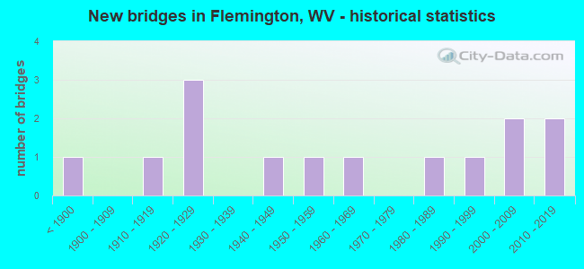
- New bridges - historical statistics
- 1Before 1900
- 11910-1919
- 31920-1929
- 11940-1949
- 11950-1959
- 11960-1969
- 11980-1989
- 11990-1999
- 22000-2009
- 22010-2019

- Bridge Condition - Deck
- 20.0%Very good
- 40.0%Good
- 20.0%Fair
- 20.0%Poor

- Bridge Condition - Superstructure
- 11.1%Very good
- 44.4%Good
- 11.1%Satisfactory
- 22.2%Poor
- 11.1%Serious

- Bridge Condition - Substructure
- 11.1%Very good
- 55.6%Good
- 11.1%Satisfactory
- 22.2%Fair

- Bridge Condition - Channel
- 22.2%Very good
- 44.4%Good
- 11.1%Satisfactory
- 22.2%Fair
Find on map >> Show street view
Structure Number: 46A02, Location: 0.01 MI EAST CO RT 13/20 (Lat: 39.268111, Lng: -80.170689), Route carried "on" structure: County highway 1302, Year Built: 1923, Status: Posted for load, Structure Length: 1.54m (5.05ft), Average Daily Traffic: 30 (year 2020), Average Future Daily Traffic: 35 (year 2040), Features Intersected: SIMPSON CREEK, Facility Carried by Structure: TAYLOR CO RT 13/2
Minimum Vertical Clearance: 30+ m (98+ ft), Kilometerpoint: 0.032, Lanes on structure: 1, Owner: State Highway Agency, Approaching Roadway Width: 4.6m (15.1ft), Material/Design: Concrete, Design/Construction: Arch - Deck, Number Of Spans In Main Unit: 1, Length of Maximum Span: 15.4m (50.5ft), Curb or Sidewalk Widths: Left: 0.1m (0.3ft), Right: 0.1m (0.3ft), Curb-To-Curb Width: 4.7m (15.4ft), Out-to-Out Width: 5.5m (18.0ft)
Condition: Superstructure: Serious, Substructure: Fair, Channel: Fair, Operating Rating: 39.9 metric tons, Method Used To Determine Operating Rating: Field evaluation and documented engineering judgment, Inventory Rating: 16.3 metric tons, Method Used To Determine Inventory Rating: Field evaluation and documented engineering judgment, Structural Evaluation: High priority of corrective action, Deck Geometry: Better than present minimum criteria, Waterway Adequacy: Equal to present minimum criteria, Approach Roadway Alignment: Somewhat better than minimum adequacy, Length Of Structure Improvement: 2.32m (7.61ft), Designated Inspection Frequency: Every 24 months, Other Special Inspection Frequency: Every 12 months, Inspection Date: April 2020, Other Special Inspection Date: April 2021, Bridge Improvement Cost: $253,000, Roadway Improvement Cost: $214,000, Total Project Cost: $557,000 ( Estimate for 2020)
Find on map >> Show street view
Structure Number: 46A022, Location: 0.01 MI NORTH C R 13/23 (Lat: 39.268139, Lng: -80.162931), Route carried "on" structure: County highway 1313, Year Built: 1954, Status: Posted for load, Structure Length: 1.89m (6.20ft), Average Daily Traffic: 50 (year 2019), Average Future Daily Traffic: 90 (year 2041), Features Intersected: SIMPSON CREEK, Facility Carried by Structure: TAYLOR CO RT 13/13
Minimum Vertical Clearance: 30+ m (98+ ft), Kilometerpoint: 0.048, Lanes on structure: 1, Owner: State Highway Agency, Approaching Roadway Width: 4.3m (14.1ft), Material/Design: Steel, Design/Construction: Girder and Floorbeam System, Number Of Spans In Main Unit: 1, Length of Maximum Span: 17.8m (58.4ft), Curb-To-Curb Width: 4.4m (14.4ft), Out-to-Out Width: 4.6m (15.1ft)
Condition: Deck: Poor, Superstructure: Poor, Substructure: Good, Channel: Fair, Operating Rating: 12.7 metric tons, Method Used To Determine Operating Rating: Load Factor (LF), Inventory Rating: 8.2 metric tons, Method Used To Determine Inventory Rating: Load Factor (LF), Structural Evaluation: High priority of replacement, Deck Geometry: Equal to present minimum criteria, Waterway Adequacy: Equal to present minimum criteria, Approach Roadway Alignment: Better than present minimum criteria, Length Of Structure Improvement: 3.20m (10.50ft), Designated Inspection Frequency: Every 24 months, Critical Feature Inspection Frequency: Every 24 months, Inspection Date: April 2021, Critical Feature Inspection Date: April 2021, Bridge Improvement Cost: $284,000, Roadway Improvement Cost: $243,000, Total Project Cost: $647,000 ( Estimate for 2021), Deck Structure Type: Wood or Timber
Find on map >> Show street view
Structure Number: 46A025, Location: 0.01 MI EAST CO RT 13 (Lat: 39.273569, Lng: -80.080861), Route carried "on" structure: County highway 1325, Year Built: 1897, Status: Posted for load, Structure Length: 2.62m (8.60ft), Average Daily Traffic: 10 (year 2018), Average Future Daily Traffic: 12 (year 2038), Design Load: H 10, Features Intersected: CSX RAILROAD, Facility Carried by Structure: TAYLOR CO RT 13/25
Minimum Vertical Clearance: 30+ m (98+ ft), Kilometerpoint: 0.016, Lanes on structure: 2, Owner: Railroad, Approaching Roadway Width: 2.7m (8.9ft), Material/Design: Steel, Design/Construction: Girder and Floorbeam System, Number Of Spans In Main Unit: 1, Length of Maximum Span: 24.4m (80.1ft), Curb-To-Curb Width: 5.5m (18.0ft), Out-to-Out Width: 6.3m (20.7ft)
Condition: Deck: Fair, Superstructure: Poor, Substructure: Fair, Operating Rating: 10.9 metric tons, Method Used To Determine Operating Rating: Load Factor (LF), Inventory Rating: 6.3 metric tons, Method Used To Determine Inventory Rating: Load Factor (LF), Structural Evaluation: High priority of replacement, Deck Geometry: Meets minimum limits, Underclear: High priority of replacement, Approach Roadway Alignment: Meets minimum limits, Bridge Posting: Required (Relationship of Operating Rating to Maximum Legal Load: > 39.9% below), Length Of Structure Improvement: 3.38m (11.09ft), Designated Inspection Frequency: Every 24 months, Critical Feature Inspection Frequency: Every 24 months, Inspection Date: October 2020, Critical Feature Inspection Date: October 2020, Bridge Improvement Cost: $281,000, Roadway Improvement Cost: $254,000, Total Project Cost: $638,000 ( Estimate for 2021), Deck Structure Type: Wood or Timber
Find on map >> Show street view
Structure Number: 46A065, Location: 0.07 MI SOUTH CO RT 13 (Lat: 39.266481, Lng: -80.098881), Route carried "on" structure: County highway 1305, Year Built: 1916, Status: Open, Structure Length: 0.62m (2.03ft), Average Daily Traffic: 100 (year 2019), Truck Traffic: 8%, Average Future Daily Traffic: 180 (year 2041), Features Intersected: RIGHT FORK SIMPSON CREEK, Facility Carried by Structure: TAYLOR CO RT 13/5
Minimum Vertical Clearance: 30+ m (98+ ft), Kilometerpoint: 0.113, Lanes on structure: 1, Owner: State Highway Agency, Approaching Roadway Width: 4.3m (14.1ft), Material/Design: Concrete, Design/Construction: Arch - Deck, Number Of Spans In Main Unit: 1, Length of Maximum Span: 6.2m (20.3ft), Curb or Sidewalk Widths: Left: 0.2m (0.7ft), Right: 0.2m (0.7ft), Curb-To-Curb Width: 4.1m (13.5ft), Out-to-Out Width: 4.9m (16.1ft)
Condition: Superstructure: Satisfactory, Substructure: Satisfactory, Channel: Satisfactory, Operating Rating: 47.2 metric tons, Method Used To Determine Operating Rating: Field evaluation and documented engineering judgment, Inventory Rating: 21.8 metric tons, Method Used To Determine Inventory Rating: Field evaluation and documented engineering judgment, Structural Evaluation: Equal to present minimum criteria, Deck Geometry: Somewhat better than minimum adequacy, Waterway Adequacy: Equal to present minimum criteria, Approach Roadway Alignment: Better than present minimum criteria, Length Of Structure Improvement: 1.25m (4.10ft), Designated Inspection Frequency: Every 24 months, Inspection Date: April 2021, Bridge Improvement Cost: $183,000, Roadway Improvement Cost: $124,000, Total Project Cost: $364,000 ( Estimate for 2021)
Find on map >> Show street view
Structure Number: 46A07, Location: 0.04 MI NORTH CO RT 13 (Lat: 39.281261, Lng: -80.068611), Route carried "on" structure: County highway 1307, Year Built: 1988, Status: Open, Structure Length: 0.96m (3.15ft), Average Daily Traffic: 50 (year 2020), Average Future Daily Traffic: 60 (year 2040), Design Load: HS 25 or greater, Features Intersected: LONG RUN, Facility Carried by Structure: TAYLOR CO RT 13/7
Minimum Vertical Clearance: 30+ m (98+ ft), Kilometerpoint: 0.064, Lanes on structure: 1, Owner: State Highway Agency, Approaching Roadway Width: 3.7m (12.1ft), Material/Design: Prestressed concrete, Design/Construction: Box Beam or Girders - Multiple, Number Of Spans In Main Unit: 1, Length of Maximum Span: 9.1m (29.9ft), Curb-To-Curb Width: 4.4m (14.4ft), Out-to-Out Width: 4.6m (15.1ft)
Condition: Deck: Good, Superstructure: Good, Substructure: Good, Channel: Good, Operating Rating: 88.9 metric tons, Method Used To Determine Operating Rating: Load Factor (LF), Inventory Rating: 59.0 metric tons, Method Used To Determine Inventory Rating: Load Factor (LF), Structural Evaluation: Better than present minimum criteria, Deck Geometry: Equal to present minimum criteria, Waterway Adequacy: Equal to present minimum criteria, Approach Roadway Alignment: Equal to present desirable criteria, Designated Inspection Frequency: Every 48 months, Inspection Date: December 2020, Deck Structure Type: Other, Wearing Surface/Protective System: Deck Protection: Epoxy Coated Reinforcing
Find on map >> Show street view
Structure Number: 46A074, Location: 0.24 MI NORTH WV RT 76 (Lat: 39.266081, Lng: -80.132331), Route carried "on" structure: County highway 300, Year Built: 1994, Status: Open, Structure Length: 0.84m (2.76ft), Average Daily Traffic: 600 (year 2018), Truck Traffic: 6%, Average Future Daily Traffic: 700 (year 2038), Design Load: HS 25 or greater, Features Intersected: BERRY RUN, Facility Carried by Structure: TAYLOR CO RT 3
Minimum Vertical Clearance: 30+ m (98+ ft), Kilometerpoint: 0.386, Lanes on structure: 2, Owner: State Highway Agency, Approaching Roadway Width: 6.1m (20.0ft), Skew: 1 degrees, Material/Design: Prestressed concrete, Design/Construction: Box Beam or Girders - Multiple, Number Of Spans In Main Unit: 1, Length of Maximum Span: 7.3m (24.0ft), Curb-To-Curb Width: 6.4m (21.0ft), Out-to-Out Width: 6.4m (21.0ft)
Condition: Superstructure: Good, Substructure: Good, Channel: Good, Operating Rating: 88.9 metric tons, Method Used To Determine Operating Rating: Load Factor (LF), Inventory Rating: 72.6 metric tons, Method Used To Determine Inventory Rating: Load Factor (LF), Structural Evaluation: Better than present minimum criteria, Deck Geometry: High priority of corrective action, Waterway Adequacy: Equal to present minimum criteria, Approach Roadway Alignment: Better than present minimum criteria, Designated Inspection Frequency: Every 24 months, Inspection Date: April 2020, Deck Structure Type: Other, Wearing Surface/Protective System: Wearing Surface: Bituminous, Deck Protection: Epoxy Coated Reinforcing
Find on map >> Show street view
Structure Number: 46A083, Location: 0.06 MI EAST TAYLOR CO 13 (Lat: 39.265700, Lng: -80.131050), Route carried "on" structure: State highway 7600, Year Built: 2003, Status: Open, Structure Length: 3.73m (12.24ft), Average Daily Traffic: 1,700 (year 2019), Truck Traffic: 6%, Average Future Daily Traffic: 1,785 (year 2041), Design Load: HL 93, Features Intersected: SIMPSON CREEK, Facility Carried by Structure: WV ROUTE 76
Minimum Vertical Clearance: 30+ m (98+ ft), Kilometerpoint: 7.339, Lanes on structure: 2, Owner: State Highway Agency, Approaching Roadway Width: 7.6m (24.9ft), Skew: 4 degrees, Material/Design: Prestressed concrete continuous, Design/Construction: Box Beam or Girders - Multiple, Number Of Spans In Main Unit: 1, Number Of Approach Spans: 2, Length of Maximum Span: 15.2m (49.9ft), Curb or Sidewalk Widths: Left: 1.5m (4.9ft), Right: 0.0m, Curb-To-Curb Width: 9.1m (29.9ft), Out-to-Out Width: 11.4m (37.4ft)
Condition: Deck: Good, Superstructure: Good, Substructure: Good, Channel: Very good, Operating Rating: 66.2 metric tons, Method Used To Determine Operating Rating: Load and Resistance Factor (LRFR), Inventory Rating: 50.8 metric tons, Method Used To Determine Inventory Rating: Load and Resistance Factor (LRFR), Structural Evaluation: Better than present minimum criteria, Deck Geometry: Somewhat better than minimum adequacy, Waterway Adequacy: Equal to present minimum criteria, Approach Roadway Alignment: Better than present minimum criteria, Designated Inspection Frequency: Every 48 months, Inspection Date: July 2021, Deck Structure Type: Concrete Cast-file-Place, Wearing Surface/Protective System: Deck Protection: Epoxy Coated Reinforcing
Find on map >> Show street view
Structure Number: 46A084, Location: 0.22 MI WEST TAY CO RT 13 (Lat: 39.265550, Lng: -80.108700), Route carried "on" structure: County highway 1321, Year Built: 2003, Status: Open, Structure Length: 0.75m (2.46ft), Average Daily Traffic: 10 (year 2019), Average Future Daily Traffic: 14 (year 2041), Design Load: HS 25 or greater, Features Intersected: RIGHT FORK SIMPSON CREEK, Facility Carried by Structure: TAYLOR CO RT 13/21
Minimum Vertical Clearance: 30+ m (98+ ft), Kilometerpoint: 1.046, Lanes on structure: 2, Owner: State Highway Agency, Approaching Roadway Width: 3.7m (12.1ft), Material/Design: Aluminum, Iron, Design/Construction: Culvert, Number Of Spans In Main Unit: 1, Length of Maximum Span: 7.5m (24.6ft)
Condition: Channel: Very good, Culverts: Very good, Operating Rating: 88.9 metric tons, Method Used To Determine Operating Rating: Field evaluation and documented engineering judgment, Inventory Rating: 40.8 metric tons, Method Used To Determine Inventory Rating: Field evaluation and documented engineering judgment, Structural Evaluation: Equal to present desirable criteria, Waterway Adequacy: Better than present minimum criteria, Approach Roadway Alignment: Equal to present minimum criteria, Designated Inspection Frequency: Every 48 months, Inspection Date: May 2021
Find on map >> Show street view
Structure Number: 46A092, Location: 0.16 MILES NORTH OF WV 76 (Lat: 39.268700, Lng: -80.132250), Route carried "on" structure: County highway 300, Year Built: 2010, Status: Open, Structure Length: 1.62m (5.31ft), Average Daily Traffic: 600 (year 2018), Truck Traffic: 6%, Average Future Daily Traffic: 700 (year 2038), Design Load: HL 93, Features Intersected: BERRY RUN, Facility Carried by Structure: TAY CO RT 3
Minimum Vertical Clearance: 30+ m (98+ ft), Kilometerpoint: 0.257, Lanes on structure: 2, Owner: State Highway Agency, Approaching Roadway Width: 5.8m (19.0ft), Skew: 5 degrees, Material/Design: Prestressed concrete, Design/Construction: Box Beam or Girders - Multiple, Number Of Spans In Main Unit: 1, Length of Maximum Span: 14.6m (47.9ft), Curb-To-Curb Width: 6.5m (21.3ft), Out-to-Out Width: 6.6m (21.7ft)
Condition: Superstructure: Good, Substructure: Good, Channel: Good, Operating Rating: 77.1 metric tons, Method Used To Determine Operating Rating: Load and Resistance Factor (LRFR), Inventory Rating: 59.0 metric tons, Method Used To Determine Inventory Rating: Load and Resistance Factor (LRFR), Structural Evaluation: Better than present minimum criteria, Deck Geometry: High priority of corrective action, Waterway Adequacy: Equal to present minimum criteria, Approach Roadway Alignment: Equal to present minimum criteria, Designated Inspection Frequency: Every 24 months, Inspection Date: April 2020, Deck Structure Type: Other, Wearing Surface/Protective System: Wearing Surface: Bituminous, Deck Protection: Epoxy Coated Reinforcing
Find on map >> Show street view
Structure Number: 46A095, Location: 0.02 mi N of WV 76 (Lat: 39.256300, Lng: -80.126500), Route carried "on" structure: County highway 133, Year Built: 2018, Status: Open, Structure Length: 1.65m (5.41ft), Average Daily Traffic: 100 (year 2019), Average Future Daily Traffic: 180 (year 2041), Design Load: HL 93, Features Intersected: Simpson Creek, Facility Carried by Structure: Tay Co Rt 13/3
Minimum Vertical Clearance: 30+ m (98+ ft), Kilometerpoint: 0.032, Lanes on structure: 2, Owner: State Highway Agency, Approaching Roadway Width: 7.3m (24.0ft), Skew: 2 degrees, Material/Design: Prestressed concrete, Design/Construction: Box Beam or Girders - Multiple, Number Of Spans In Main Unit: 1, Length of Maximum Span: 15.2m (49.9ft), Curb-To-Curb Width: 7.4m (24.3ft), Out-to-Out Width: 7.4m (24.3ft)
Condition: Deck: Very good, Superstructure: Very good, Substructure: Very good, Channel: Good, Operating Rating: 59.0 metric tons, Method Used To Determine Operating Rating: Load and Resistance Factor (LRFR), Inventory Rating: 45.4 metric tons, Method Used To Determine Inventory Rating: Load and Resistance Factor (LRFR), Structural Evaluation: Equal to present desirable criteria, Deck Geometry: Equal to present minimum criteria, Waterway Adequacy: Better than present minimum criteria, Approach Roadway Alignment: Equal to present minimum criteria, Designated Inspection Frequency: Every 24 months, Inspection Date: May 2021, Deck Structure Type: Other, Wearing Surface/Protective System: Deck Protection: Epoxy Coated Reinforcing
Find on map >> Show street view
Structure Number: 46A016, Location: 0.02 MI NORTH CR 13 (Lat: 39.267639, Lng: -80.094111), Route carried "under" structure: County highway 1100, Year Built: 1923, Structure Length: 0. m, Average Daily Traffic: 250 (year 2018), Truck Traffic: 6%, Features Intersected: CSX RAILROAD, Facility Carried by Structure: CSX RAILROAD
Minimum Vertical Clearance: 4.67m (15.32ft), Kilometerpoint: 0.032, Lanes under structure: 2, Length of Maximum Span: 6.7m (22.0ft)
Find on map >> Show street view
Structure Number: 46A019, Location: 0.06 MI EAST CR 13/7 (Lat: 39.280761, Lng: -80.066900), Route carried "under" structure: County highway 1300, Year Built: 1923, Structure Length: 0. m, Average Daily Traffic: 1,200 (year 2018), Truck Traffic: 6%, Features Intersected: CSX RAILROAD, Facility Carried by Structure: CSX RAILROAD
Minimum Vertical Clearance: 5.89m (19.32ft), Kilometerpoint: 7.274, Lanes under structure: 2, Length of Maximum Span: 10.4m (34.1ft)
Find on map >> Show street view
Structure Number: 46A032, Location: 0.02 MI NORTH CR 13 (Lat: 39.268239, Lng: -80.104369), Route carried "under" structure: County highway 3400, Year Built: 1963, Structure Length: 0. m, Average Daily Traffic: 100 (year 2018), Features Intersected: CSX RAILROAD, Facility Carried by Structure: CSX RAILROAD
Minimum Vertical Clearance: 4.09m (13.42ft), Kilometerpoint: 0.032, Lanes under structure: 1, Length of Maximum Span: 8.8m (28.9ft)
Find on map >> Show street view
Structure Number: 46A047, Location: 0.01 MI EAST CO RT 3 (Lat: 39.266219, Lng: -80.131911), Route carried "under" structure: State highway 7600, Year Built: 1940, Structure Length: 0. m, Average Daily Traffic: 1,700 (year 2018), Truck Traffic: 7%, Features Intersected: CSX RAILROAD, Facility Carried by Structure: CSX RAILROAD
Minimum Vertical Clearance: 4.32m (14.17ft), Kilometerpoint: 7.258, Lanes under structure: 2, Length of Maximum Span: 9.8m (32.2ft)