Bridge Statistics for Florence, Colorado (CO)
Condition, Traffic, Stress, Structural Evaluation, Project Costs
- National Bridge Inventory (NBI) Statistics
- 18Number of bridges
- 157ft / 47.6mTotal length
- $1,826,000Total costs
- 40,052Total average daily traffic
- 1,915Total average daily truck traffic
- 45,787Total future (year 2038) average daily traffic
- National Bridge Inventory (NBI) Registered Bridges for Florence
- No street view available for this location
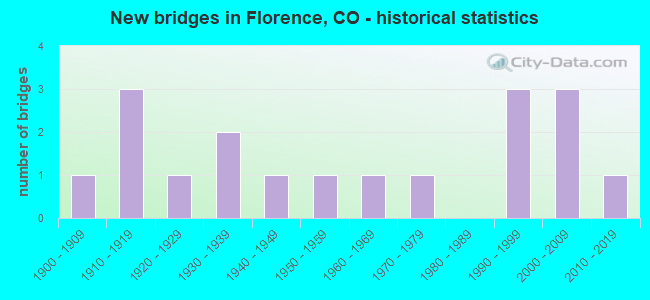
- New bridges - historical statistics
- 11900-1909
- 31910-1919
- 11920-1929
- 21930-1939
- 11940-1949
- 11950-1959
- 11960-1969
- 11970-1979
- 31990-1999
- 32000-2009
- 12010-2019


- Bridge Condition - Deck
- 35.7%Good
- 28.6%Satisfactory
- 35.7%Fair

- Bridge Condition - Superstructure
- 14.3%Very good
- 28.6%Good
- 35.7%Satisfactory
- 21.4%Fair

- Bridge Condition - Substructure
- 35.7%Good
- 28.6%Satisfactory
- 35.7%Fair

- Bridge Condition - Channel
- 5.6%Very good
- 38.9%Good
- 50.0%Satisfactory
- 5.6%Poor

- Bridge Condition - Culverts
- 25.0%Good
- 50.0%Satisfactory
- 25.0%Fair
Find on map >> Show street view
Structure Number: FLOR 001-W2NDST, Location: JUST N OF N HOUSTON AV (Lat: 38.396189, Lng: -105.130064), Route carried "on" structure: City street , Year Built: 1908, Status: Open, Structure Length: 1.65m (5.41ft), Average Daily Traffic: 170 (year 2018), Truck Traffic: 2%, Average Future Daily Traffic: 243 (year 2038), Features Intersected: OAK CREEK, Facility Carried by Structure: W 2ND STREET
Minimum Vertical Clearance: 30+ m (98+ ft), Kilometerpoint: 0.000, Lanes on structure: 2, Owner: City or Municipal Highway Agency, Approaching Roadway Width: 6.7m (22.0ft), Material/Design: Concrete, Design/Construction: Arch - Deck, Number Of Spans In Main Unit: 1, Length of Maximum Span: 16.5m (54.1ft), Curb or Sidewalk Widths: Left: 0.9m (3.0ft), Right: 0.0m, Curb-To-Curb Width: 5.3m (17.4ft), Out-to-Out Width: 6.6m (21.7ft)
Condition: Deck: Fair, Superstructure: Fair, Substructure: Fair, Channel: Good, Operating Rating: 36.3 metric tons, Method Used To Determine Operating Rating: Field evaluation and documented engineering judgment, Inventory Rating: 32.7 metric tons, Method Used To Determine Inventory Rating: Field evaluation and documented engineering judgment, Structural Evaluation: Somewhat better than minimum adequacy, Deck Geometry: High priority of replacement, Waterway Adequacy: Equal to present desirable criteria, Approach Roadway Alignment: Equal to present desirable criteria, Length Of Structure Improvement: 2.29m (7.51ft), Designated Inspection Frequency: Every 24 months, Inspection Date: Febuary 2021, Bridge Improvement Cost: $407,000, Roadway Improvement Cost: $41,000, Total Project Cost: $610,000 ( Estimate for 2017), Deck Structure Type: Concrete Cast-file-Place, Wearing Surface/Protective System: Wearing Surface: Bituminous
Find on map >> Show street view
Structure Number: FLOR 002-3RD ST, Location: Just E of N Petroleum Ave (Lat: 38.391619, Lng: -105.115356), Route carried "on" structure: City street , Year Built: 1916, Status: Open, Structure Length: 1.37m (4.49ft), Average Daily Traffic: 1,149 (year 2018), Truck Traffic: 5%, Average Future Daily Traffic: 1,642 (year 2038), Features Intersected: COAL CREEK, Facility Carried by Structure: E 3RD STREET
Minimum Vertical Clearance: 30+ m (98+ ft), Kilometerpoint: 0.177, Lanes on structure: 2, Owner: City or Municipal Highway Agency, Approaching Roadway Width: 16.5m (54.1ft), Material/Design: Concrete, Design/Construction: Arch - Deck, Number Of Spans In Main Unit: 1, Length of Maximum Span: 13.7m (44.9ft), Curb or Sidewalk Widths: Left: 0.0m, Right: 1.0m (3.3ft), Curb-To-Curb Width: 10.7m (35.1ft), Out-to-Out Width: 12.2m (40.0ft)
Condition: Deck: Fair, Superstructure: Fair, Substructure: Fair, Channel: Good, Operating Rating: 36.3 metric tons, Method Used To Determine Operating Rating: Field evaluation and documented engineering judgment, Inventory Rating: 32.7 metric tons, Method Used To Determine Inventory Rating: Field evaluation and documented engineering judgment, Structural Evaluation: Somewhat better than minimum adequacy, Deck Geometry: Equal to present minimum criteria, Waterway Adequacy: Equal to present desirable criteria, Approach Roadway Alignment: Equal to present desirable criteria, Designated Inspection Frequency: Every 24 months, Inspection Date: January 2021, Deck Structure Type: Concrete Cast-file-Place, Wearing Surface/Protective System: Wearing Surface: Bituminous
Find on map >> Show street view
Structure Number: FLOR 003A-PETRO, Location: JUST NORTH OF 3RD STREET (Lat: 38.392603, Lng: -105.115297), Route carried "on" structure: City street , Year Built: 1991, Status: Open, Structure Length: 1.97m (6.46ft), Average Daily Traffic: 411 (year 2018), Truck Traffic: 2%, Average Future Daily Traffic: 587 (year 2038), Design Load: HS 20, Features Intersected: COAL CREEK, Facility Carried by Structure: PETROLEUM AVE
Minimum Vertical Clearance: 30+ m (98+ ft), Kilometerpoint: 0.453, Lanes on structure: 2, Owner: City or Municipal Highway Agency, Approaching Roadway Width: 7.3m (24.0ft), Skew: 3 degrees, Material/Design: Prestressed concrete, Design/Construction: Tee Beam, Number Of Spans In Main Unit: 1, Length of Maximum Span: 19.0m (62.3ft), Curb or Sidewalk Widths: Left: 1.2m (3.9ft), Right: 1.2m (3.9ft), Curb-To-Curb Width: 7.4m (24.3ft), Out-to-Out Width: 10.0m (32.8ft)
Condition: Deck: Satisfactory, Superstructure: Satisfactory, Substructure: Satisfactory, Channel: Good, Operating Rating: 54.7 metric tons, Method Used To Determine Operating Rating: Load Factor (LF), Inventory Rating: 35.4 metric tons, Method Used To Determine Inventory Rating: Load Factor (LF), Structural Evaluation: Equal to present minimum criteria, Deck Geometry: Meets minimum limits, Waterway Adequacy: Better than present minimum criteria, Approach Roadway Alignment: Equal to present desirable criteria, Designated Inspection Frequency: Every 24 months, Inspection Date: March 2021, Deck Structure Type: Other, Wearing Surface/Protective System: Wearing Surface: Monolithic Concrete
Find on map >> Show street view
Structure Number: FLOR 005-E2NDST, Location: JUST E OF PETROLEUM AV (Lat: 38.390394, Lng: -105.114472), Route carried "on" structure: City street , Year Built: 1918, Year Reconstructed: 1997, Status: Open, Structure Length: 1.46m (4.79ft), Average Daily Traffic: 1,061 (year 2018), Truck Traffic: 2%, Average Future Daily Traffic: 1,517 (year 2038), Design Load: HS 20, Features Intersected: COAL CREEK, Facility Carried by Structure: E 2ND STREET
Minimum Vertical Clearance: 30+ m (98+ ft), Kilometerpoint: 0.283, Lanes on structure: 2, Owner: City or Municipal Highway Agency, Approaching Roadway Width: 13.7m (44.9ft), Skew: 3 degrees, Material/Design: Steel, Design/Construction: Stringer/Multi-beam, Number Of Spans In Main Unit: 1, Length of Maximum Span: 13.0m (42.7ft), Curb or Sidewalk Widths: Left: 4.7m (15.4ft), Right: 4.4m (14.4ft), Curb-To-Curb Width: 13.7m (44.9ft), Out-to-Out Width: 24.5m (80.4ft)
Condition: Deck: Good, Superstructure: Very good, Substructure: Fair, Channel: Satisfactory, Operating Rating: 78.6 metric tons, Method Used To Determine Operating Rating: Load Factor (LF), Inventory Rating: 47.2 metric tons, Method Used To Determine Inventory Rating: Load Factor (LF), Structural Evaluation: Somewhat better than minimum adequacy, Deck Geometry: Superior to present desirable criteria, Waterway Adequacy: Better than present minimum criteria, Approach Roadway Alignment: Equal to present desirable criteria, Designated Inspection Frequency: Every 24 months, Inspection Date: Febuary 2021, Deck Structure Type: Concrete Cast-file-Place, Wearing Surface/Protective System: Wearing Surface: Bituminous, Membrane: Built-up, Deck Protection: Epoxy Coated Reinforcing
Find on map >> Show street view
Structure Number: FLOR 006-RR ST., Location: IN FLORENCE (Lat: 38.387281, Lng: -105.116253), Route carried "on" structure: City street , Year Built: 1918, Status: Open, Structure Length: 1.34m (4.40ft), Average Daily Traffic: 878 (year 2018), Truck Traffic: 2%, Average Future Daily Traffic: 1,256 (year 2038), Features Intersected: COAL CREEK, Facility Carried by Structure: RAILROAD STREET
Minimum Vertical Clearance: 30+ m (98+ ft), Kilometerpoint: 0.227, Lanes on structure: 2, Owner: City or Municipal Highway Agency, Approaching Roadway Width: 7.9m (25.9ft), Material/Design: Concrete, Design/Construction: Arch - Deck, Number Of Spans In Main Unit: 1, Length of Maximum Span: 13.4m (44.0ft), Curb-To-Curb Width: 7.3m (24.0ft), Out-to-Out Width: 7.8m (25.6ft)
Condition: Deck: Fair, Superstructure: Fair, Substructure: Fair, Channel: Good, Operating Rating: 36.3 metric tons, Method Used To Determine Operating Rating: Field evaluation and documented engineering judgment, Inventory Rating: 32.7 metric tons, Method Used To Determine Inventory Rating: Field evaluation and documented engineering judgment, Structural Evaluation: Somewhat better than minimum adequacy, Deck Geometry: Meets minimum limits, Waterway Adequacy: Equal to present desirable criteria, Approach Roadway Alignment: Equal to present desirable criteria, Designated Inspection Frequency: Every 24 months, Inspection Date: January 2021, Deck Structure Type: Concrete Cast-file-Place, Wearing Surface/Protective System: Wearing Surface: Bituminous
Find on map >> Show street view
Structure Number: FLOR004A-E5THST, Location: JUST E OF SH 67/PIKES (Lat: 38.393869, Lng: -105.115875), Route carried "on" structure: City street , Year Built: 2000, Status: Open, Structure Length: 1.98m (6.50ft), Average Daily Traffic: 553 (year 2018), Truck Traffic: 2%, Average Future Daily Traffic: 791 (year 2038), Features Intersected: COAL CREEK, Facility Carried by Structure: E 5TH STREET
Minimum Vertical Clearance: 30+ m (98+ ft), Kilometerpoint: 0.206, Lanes on structure: 2, Owner: City or Municipal Highway Agency, Approaching Roadway Width: 9.8m (32.2ft), Material/Design: Steel, Design/Construction: Stringer/Multi-beam, Number Of Spans In Main Unit: 1, Length of Maximum Span: 18.6m (61.0ft), Curb-To-Curb Width: 13.4m (44.0ft), Out-to-Out Width: 14.2m (46.6ft)
Condition: Deck: Satisfactory, Superstructure: Very good, Substructure: Good, Channel: Good, Operating Rating: 80.0 metric tons, Method Used To Determine Operating Rating: Load Factor (LF), Inventory Rating: 47.9 metric tons, Method Used To Determine Inventory Rating: Load Factor (LF), Structural Evaluation: Better than present minimum criteria, Deck Geometry: Superior to present desirable criteria, Waterway Adequacy: Better than present minimum criteria, Approach Roadway Alignment: Equal to present desirable criteria, Designated Inspection Frequency: Every 24 months, Inspection Date: Febuary 2021, Deck Structure Type: Concrete Cast-file-Place, Wearing Surface/Protective System: Wearing Surface: Monolithic Concrete, Deck Protection: Epoxy Coated Reinforcing
Find on map >> Show street view
Structure Number: FRCO 19-209A, Location: 5 MI SE OF SH 67 (Lat: 38.343131, Lng: -105.068503), Route carried "on" structure: County highway , Year Built: 1995, Status: Open, Structure Length: 2.43m (7.97ft), Average Daily Traffic: 169 (year 2018), Average Future Daily Traffic: 241 (year 2038), Features Intersected: HARDSCRABBLE CREEK, Facility Carried by Structure: CR19 / BEAR PAW
Minimum Vertical Clearance: 30+ m (98+ ft), Kilometerpoint: 3.486, Lanes on structure: 2, Owner: County Highway Agency, Approaching Roadway Width: 6.7m (22.0ft), Material/Design: Steel, Design/Construction: Stringer/Multi-beam, Number Of Spans In Main Unit: 1, Length of Maximum Span: 22.8m (74.8ft), Curb-To-Curb Width: 6.9m (22.6ft), Out-to-Out Width: 7.6m (24.9ft)
Condition: Deck: Fair, Superstructure: Satisfactory, Substructure: Good, Channel: Satisfactory, Operating Rating: 59.1 metric tons, Method Used To Determine Operating Rating: Load Factor (LF), Inventory Rating: 35.4 metric tons, Method Used To Determine Inventory Rating: Load Factor (LF), Structural Evaluation: Equal to present minimum criteria, Deck Geometry: Meets minimum limits, Waterway Adequacy: Equal to present desirable criteria, Approach Roadway Alignment: Equal to present minimum criteria, Length Of Structure Improvement: 0.77m (2.53ft), Designated Inspection Frequency: Every 24 months, Inspection Date: Febuary 2021, Bridge Improvement Cost: $650,000, Roadway Improvement Cost: $65,000, Total Project Cost: $974,000 ( Estimate for 2015), Deck Structure Type: Corrugated Steel, Wearing Surface/Protective System: Wearing Surface: Bituminous
Find on map >> Show street view
Structure Number: FRCO 79-206A, Location: 1.8 MI E OF ADAMS AVENUE (Lat: 38.395728, Lng: -105.131764), Route carried "on" structure: County highway , Year Built: 1990, Status: Open, Structure Length: 1.05m (3.44ft), Average Daily Traffic: 57 (year 2018), Average Future Daily Traffic: 82 (year 2038), Design Load: HS 20+Mod, Features Intersected: OAK CREEK, Facility Carried by Structure: COUNTY ROAD 79
Minimum Vertical Clearance: 30+ m (98+ ft), Kilometerpoint: 2.889, Lanes on structure: 2, Owner: County Highway Agency, Approaching Roadway Width: 8.5m (27.9ft), Skew: 3 degrees, Material/Design: Steel, Design/Construction: Stringer/Multi-beam, Number Of Spans In Main Unit: 1, Length of Maximum Span: 8.7m (28.5ft), Curb-To-Curb Width: 5.5m (18.0ft), Out-to-Out Width: 5.6m (18.4ft)
Condition: Deck: Good, Superstructure: Good, Substructure: Satisfactory, Channel: Satisfactory, Operating Rating: 73.2 metric tons, Method Used To Determine Operating Rating: Load Factor (LF), Inventory Rating: 43.8 metric tons, Method Used To Determine Inventory Rating: Load Factor (LF), Structural Evaluation: Equal to present minimum criteria, Deck Geometry: Meets minimum limits, Waterway Adequacy: Equal to present desirable criteria, Approach Roadway Alignment: High priority of corrective action, Designated Inspection Frequency: Every 24 months, Inspection Date: January 2021, Deck Structure Type: Corrugated Steel, Wearing Surface/Protective System: Wearing Surface: Bituminous
Find on map >> Show street view
Structure Number: FRCO 95-205A, Location: 1.5 MI W OF SH 67 (Lat: 38.363839, Lng: -105.126911), Route carried "on" structure: County highway , Year Built: 2007, Status: Open, Structure Length: 0.87m (2.85ft), Average Daily Traffic: 304 (year 2018), Truck Traffic: 2%, Average Future Daily Traffic: 434 (year 2038), Features Intersected: SECOND ALKALI CREEK, Facility Carried by Structure: COUNTY ROAD 95
Minimum Vertical Clearance: 30+ m (98+ ft), Kilometerpoint: 0.777, Lanes on structure: 2, Owner: County Highway Agency, Approaching Roadway Width: 9.8m (32.2ft), Material/Design: Concrete, Design/Construction: Culvert, Number Of Spans In Main Unit: 2, Length of Maximum Span: 4.3m (14.1ft), Out-to-Out Width: 15.5m (50.9ft)
Condition: Channel: Satisfactory, Culverts: Good, Operating Rating: 36.3 metric tons, Method Used To Determine Operating Rating: Field evaluation and documented engineering judgment, Inventory Rating: 32.7 metric tons, Method Used To Determine Inventory Rating: Field evaluation and documented engineering judgment, Structural Evaluation: Better than present minimum criteria, Waterway Adequacy: Better than present minimum criteria, Approach Roadway Alignment: Equal to present desirable criteria, Designated Inspection Frequency: Every 24 months, Inspection Date: January 2021
Find on map >> Show street view
Structure Number: K-16-B, Location: 1.4 MI W OF JCT SH 67 (Lat: 38.442933, Lng: -105.134972), Route carried "on" structure: US 50A, Year Built: 1949, Status: Open, Structure Length: 1.52m (4.99ft), Average Daily Traffic: 7,000 (year 2020), Truck Traffic: 7%, Average Future Daily Traffic: 7,420 (year 2040), Design Load: H 20, Features Intersected: SIX MILE CREEK, Facility Carried by Structure: US 50 ML WBND
Minimum Vertical Clearance: 30+ m (98+ ft), Kilometerpoint: 405.123, Lanes on structure: 2, Base Highway Network: Yes, Owner: State Highway Agency, Approaching Roadway Width: 11.6m (38.1ft), Material/Design: Concrete, Design/Construction: Culvert, Number Of Spans In Main Unit: 1, Length of Maximum Span: 15.2m (49.9ft), Out-to-Out Width: 20.1m (65.9ft)
Condition: Channel: Good, Culverts: Satisfactory, Operating Rating: 89.8 metric tons, Method Used To Determine Operating Rating: Load Factor (LF), Inventory Rating: 89.8 metric tons, Method Used To Determine Inventory Rating: Load Factor (LF), Structural Evaluation: Equal to present minimum criteria, Waterway Adequacy: Superior to present desirable criteria, Approach Roadway Alignment: Equal to present desirable criteria, Designated Inspection Frequency: Every 24 months, Inspection Date: December 2020
Find on map >> Show street view
Structure Number: K-16-BZ, Location: 0.8 MI S. OF FLORENCE (Lat: 38.374911, Lng: -105.109753), Route carried "on" structure: State highway 67A, Year Built: 2000, Status: Open, Structure Length: 1.16m (3.81ft), Average Daily Traffic: 1,700 (year 2020), Truck Traffic: 7%, Average Future Daily Traffic: 2,040 (year 2040), Design Load: HS 20+Mod, Features Intersected: DRAW, Facility Carried by Structure: SH 67 ML
Minimum Vertical Clearance: 30.45m (99.90ft), Kilometerpoint: 16.184, Lanes on structure: 2, Owner: State Highway Agency, Approaching Roadway Width: 12.2m (40.0ft), Skew: 3 degrees, Material/Design: Concrete, Design/Construction: Culvert, Number Of Spans In Main Unit: 2, Length of Maximum Span: 5.6m (18.4ft), Out-to-Out Width: 25.6m (84.0ft)
Condition: Channel: Satisfactory, Culverts: Satisfactory, Operating Rating: 36.3 metric tons, Method Used To Determine Operating Rating: Field evaluation and documented engineering judgment, Inventory Rating: 32.7 metric tons, Method Used To Determine Inventory Rating: Field evaluation and documented engineering judgment, Structural Evaluation: Equal to present minimum criteria, Waterway Adequacy: Equal to present minimum criteria, Approach Roadway Alignment: Equal to present desirable criteria, Designated Inspection Frequency: Every 24 months, Inspection Date: June 2020
Find on map >> Show street view
Structure Number: K-16-CG, Location: JUST N. OF FLORENCE (Lat: 38.398736, Lng: -105.115089), Route carried "on" structure: State highway 67B, Year Built: 1978, Status: Open, Structure Length: 8.02m (26.31ft), Average Daily Traffic: 2,100 (year 2020), Truck Traffic: 6%, Average Future Daily Traffic: 2,310 (year 2040), Design Load: HS 20, Features Intersected: ARKANSAS RIVER, Facility Carried by Structure: SH 67 ML
Minimum Vertical Clearance: 30.45m (99.90ft), Kilometerpoint: 1.003, Lanes on structure: 2, Owner: State Highway Agency, Approaching Roadway Width: 10.7m (35.1ft), Material/Design: Prestressed concrete continuous, Design/Construction: Stringer/Multi-beam, Number Of Spans In Main Unit: 3, Length of Maximum Span: 26.2m (86.0ft), Curb-To-Curb Width: 12.2m (40.0ft), Out-to-Out Width: 13.0m (42.7ft)
Condition: Deck: Good, Superstructure: Good, Substructure: Satisfactory, Channel: Satisfactory, Operating Rating: 47.0 metric tons, Method Used To Determine Operating Rating: Load Factor (LF), Inventory Rating: 28.0 metric tons, Method Used To Determine Inventory Rating: Load Factor (LF), Structural Evaluation: Equal to present minimum criteria, Deck Geometry: Equal to present minimum criteria, Waterway Adequacy: Superior to present desirable criteria, Approach Roadway Alignment: Equal to present desirable criteria, Designated Inspection Frequency: Every 24 months, Inspection Date: June 2020, Deck Structure Type: Concrete Cast-file-Place, Wearing Surface/Protective System: Wearing Surface: Bituminous
Find on map >> Show street view
Structure Number: K-16-CI, Location: 1.5 MI E OF FLORENCE (Lat: 38.386111, Lng: -105.071944), Route carried "on" structure: State highway 120A, Year Built: 2015, Status: Open, Structure Length: 8.58m (28.15ft), Average Daily Traffic: 800 (year 2020), Truck Traffic: 11%, Average Future Daily Traffic: 984 (year 2040), Design Load: HL 93, Features Intersected: DRAW, UP RR, Facility Carried by Structure: SH 120 ML
Minimum Vertical Clearance: 30+ m (98+ ft), Kilometerpoint: 0.253, Lanes on structure: 2, Owner: State Highway Agency, Approaching Roadway Width: 12.2m (40.0ft), Material/Design: Prestressed concrete continuous, Design/Construction: Stringer/Multi-beam, Number Of Spans In Main Unit: 3, Length of Maximum Span: 35.7m (117.1ft), Curb-To-Curb Width: 12.2m (40.0ft), Out-to-Out Width: 13.1m (43.0ft)
Condition: Deck: Good, Superstructure: Good, Substructure: Good, Channel: Very good, Operating Rating: 42.4 metric tons, Method Used To Determine Operating Rating: Field evaluation and documented engineering judgment, Inventory Rating: 36.3 metric tons, Method Used To Determine Inventory Rating: Field evaluation and documented engineering judgment, Structural Evaluation: Better than present minimum criteria, Deck Geometry: Equal to present desirable criteria, Underclear: Meets minimum limits, Waterway Adequacy: Equal to present desirable criteria, Approach Roadway Alignment: Better than present minimum criteria, Designated Inspection Frequency: Every 24 months, Inspection Date: August 2020, Deck Structure Type: Concrete Cast-file-Place, Wearing Surface/Protective System: Wearing Surface: Bituminous, Membrane: Built-up
Find on map >> Show street view
Structure Number: K-16-G, Location: 0.6 Mi W OF FLORENCE (Lat: 38.402453, Lng: -105.138675), Route carried "on" structure: State highway 115A, Year Built: 1967, Status: Open, Structure Length: 1.62m (5.31ft), Average Daily Traffic: 5,900 (year 2020), Truck Traffic: 2%, Average Future Daily Traffic: 6,667 (year 2040), Design Load: HS 20, Features Intersected: CHANDLER CREEK, Facility Carried by Structure: SH 115 ML
Minimum Vertical Clearance: 30+ m (98+ ft), Kilometerpoint: 11.397, Lanes on structure: 2, Owner: State Highway Agency, Approaching Roadway Width: 7.9m (25.9ft), Material/Design: Steel, Design/Construction: Stringer/Multi-beam, Number Of Spans In Main Unit: 1, Length of Maximum Span: 15.2m (49.9ft), Curb or Sidewalk Widths: Left: 0.6m (2.0ft), Right: 0.6m (2.0ft), Curb-To-Curb Width: 9.1m (29.9ft), Out-to-Out Width: 10.4m (34.1ft)
Condition: Deck: Fair, Superstructure: Satisfactory, Substructure: Good, Channel: Good, Operating Rating: 50.6 metric tons, Method Used To Determine Operating Rating: Load Factor (LF), Inventory Rating: 30.3 metric tons, Method Used To Determine Inventory Rating: Load Factor (LF), Structural Evaluation: Equal to present minimum criteria, Deck Geometry: High priority of corrective action, Waterway Adequacy: Equal to present minimum criteria, Approach Roadway Alignment: Equal to present desirable criteria, Length Of Structure Improvement: 1.62m (5.31ft), Designated Inspection Frequency: Every 24 months, Inspection Date: August 2020, Bridge Improvement Cost: $65,000, Roadway Improvement Cost: $6,000, Total Project Cost: $97,000, Deck Structure Type: Concrete Cast-file-Place, Wearing Surface/Protective System: Wearing Surface: Bituminous
Find on map >> Show street view
Structure Number: K-16-T, Location: 0.1 MI E OF JCT SH 115 (Lat: 38.386194, Lng: -105.073714), Route carried "on" structure: State highway 120A, Year Built: 1930, Status: Open, Structure Length: 1.89m (6.20ft), Average Daily Traffic: 800 (year 2020), Truck Traffic: 11%, Average Future Daily Traffic: 984 (year 2040), Design Load: H 15, Features Intersected: COCKELBURR CREEK, Facility Carried by Structure: SH 120 ML
Minimum Vertical Clearance: 30+ m (98+ ft), Kilometerpoint: 0.103, Lanes on structure: 2, Owner: State Highway Agency, Approaching Roadway Width: 7.0m (23.0ft), Skew: 1 degrees, Material/Design: Concrete, Design/Construction: Slab, Number Of Spans In Main Unit: 3, Length of Maximum Span: 5.8m (19.0ft), Curb-To-Curb Width: 7.3m (24.0ft), Out-to-Out Width: 8.4m (27.6ft)
Condition: Deck: Satisfactory, Superstructure: Satisfactory, Substructure: Fair, Channel: Satisfactory, Operating Rating: 28.2 metric tons, Method Used To Determine Operating Rating: Load and Resistance Factor Rating (LRFR) rating reported by rating factor(RF) method using HL-93 loadings, Inventory Rating: 21.7 metric tons, Method Used To Determine Inventory Rating: Load and Resistance Factor Rating (LRFR) rating reported by rating factor(RF) method using HL-93 loadings, Structural Evaluation: Somewhat better than minimum adequacy, Deck Geometry: Meets minimum limits, Waterway Adequacy: Equal to present desirable criteria, Approach Roadway Alignment: Equal to present desirable criteria, Designated Inspection Frequency: Every 24 months, Inspection Date: August 2020, Deck Structure Type: Concrete Cast-file-Place, Wearing Surface/Protective System: Wearing Surface: Bituminous
Find on map >> Show street view
Structure Number: K-16-V, Location: 0.4 MI N OF JCT SH 120 (Lat: 38.390003, Lng: -105.069067), Route carried "on" structure: State highway 115A, Year Built: 1951, Status: Open, Structure Length: 7.40m (24.28ft), Average Daily Traffic: 4,500 (year 2020), Truck Traffic: 7%, Average Future Daily Traffic: 4,860 (year 2040), Design Load: H 20, Features Intersected: ARKANSAS RIVER, Facility Carried by Structure: SH 115 ML
Minimum Vertical Clearance: 30+ m (98+ ft), Kilometerpoint: 18.263, Lanes on structure: 2, Owner: State Highway Agency, Approaching Roadway Width: 9.4m (30.8ft), Skew: 3 degrees, Material/Design: Steel continuous, Design/Construction: Stringer/Multi-beam, Number Of Spans In Main Unit: 3, Length of Maximum Span: 27.5m (90.2ft), Curb-To-Curb Width: 7.3m (24.0ft), Out-to-Out Width: 8.5m (27.9ft)
Condition: Deck: Satisfactory, Superstructure: Satisfactory, Substructure: Satisfactory, Channel: Poor, Operating Rating: 41.2 metric tons, Method Used To Determine Operating Rating: Load Factor (LF), Inventory Rating: 24.7 metric tons, Method Used To Determine Inventory Rating: Load Factor (LF), Structural Evaluation: Equal to present minimum criteria, Deck Geometry: High priority of replacement, Waterway Adequacy: Equal to present desirable criteria, Approach Roadway Alignment: Equal to present desirable criteria, Length Of Structure Improvement: 7.41m (24.31ft), Designated Inspection Frequency: Every 24 months, Inspection Date: July 2020, Bridge Improvement Cost: $1,000, Total Project Cost: $1,000, Deck Structure Type: Concrete Cast-file-Place, Wearing Surface/Protective System: Wearing Surface: Bituminous, Membrane: Built-up
Find on map >> Show street view
Structure Number: K-16-X, Location: IN FLORENCE (Lat: 38.389181, Lng: -105.114047), Route carried "on" structure: State highway 115A, Year Built: 1921, Status: Open, Structure Length: 1.34m (4.40ft), Average Daily Traffic: 6,600 (year 2020), Truck Traffic: 5%, Average Future Daily Traffic: 7,062 (year 2040), Design Load: H 15, Features Intersected: COAL CREEK, Facility Carried by Structure: SH 115 ML
Minimum Vertical Clearance: 30+ m (98+ ft), Kilometerpoint: 14.170, Lanes on structure: 2, Owner: State Highway Agency, Approaching Roadway Width: 17.1m (56.1ft), Material/Design: Concrete, Design/Construction: Culvert, Number Of Spans In Main Unit: 1, Length of Maximum Span: 13.4m (44.0ft), Curb or Sidewalk Widths: Left: 2.0m (6.6ft), Right: 0.0m, Curb-To-Curb Width: 17.0m (55.8ft), Out-to-Out Width: 20.9m (68.6ft)
Condition: Channel: Satisfactory, Culverts: Fair, Operating Rating: 36.3 metric tons, Method Used To Determine Operating Rating: Field evaluation and documented engineering judgment, Inventory Rating: 32.7 metric tons, Method Used To Determine Inventory Rating: Field evaluation and documented engineering judgment, Structural Evaluation: Somewhat better than minimum adequacy, Deck Geometry: Superior to present desirable criteria, Waterway Adequacy: Equal to present desirable criteria, Approach Roadway Alignment: Equal to present desirable criteria, Designated Inspection Frequency: Every 24 months, Inspection Date: August 2020
Find on map >> Show street view
Structure Number: K-16-Y, Location: W. EDGE OF FLORENCE (Lat: 38.396522, Lng: -105.128372), Route carried "on" structure: State highway 115A, Year Built: 1936, Status: Open, Structure Length: 1.94m (6.36ft), Average Daily Traffic: 5,900 (year 2020), Truck Traffic: 2%, Average Future Daily Traffic: 6,667 (year 2040), Design Load: HS 25 or greater, Features Intersected: OAK CREEK, Facility Carried by Structure: SH 115 ML
Minimum Vertical Clearance: 30+ m (98+ ft), Kilometerpoint: 12.522, Lanes on structure: 2, Owner: State Highway Agency, Approaching Roadway Width: 7.9m (25.9ft), Skew: 2 degrees, Material/Design: Steel, Design/Construction: Stringer/Multi-beam, Number Of Spans In Main Unit: 1, Length of Maximum Span: 18.3m (60.0ft), Curb or Sidewalk Widths: Left: 1.5m (4.9ft), Right: 1.5m (4.9ft), Curb-To-Curb Width: 9.1m (29.9ft), Out-to-Out Width: 12.9m (42.3ft)
Condition: Deck: Good, Superstructure: Good, Substructure: Good, Channel: Satisfactory, Operating Rating: 29.0 metric tons, Method Used To Determine Operating Rating: Load Factor (LF), Inventory Rating: 17.3 metric tons, Method Used To Determine Inventory Rating: Load Factor (LF), Structural Evaluation: Meets minimum limits, Deck Geometry: High priority of corrective action, Waterway Adequacy: Equal to present desirable criteria, Approach Roadway Alignment: Equal to present desirable criteria, Length Of Structure Improvement: 1.92m (6.30ft), Designated Inspection Frequency: Every 24 months, Inspection Date: August 2020, Bridge Improvement Cost: $96,000, Roadway Improvement Cost: $10,000, Total Project Cost: $144,000, Deck Structure Type: Concrete Cast-file-Place, Wearing Surface/Protective System: Wearing Surface: Bituminous