Bridge Statistics for Florence, Texas (TX)
Condition, Traffic, Stress, Structural Evaluation, Project Costs
- National Bridge Inventory (NBI) Statistics
- 39Number of bridges
- 699ft / 213mTotal length
- $21,000Total costs
- 216,850Total average daily traffic
- 20,168Total average daily truck traffic
- National Bridge Inventory (NBI) Registered Bridges for Florence
- No street view available for this location
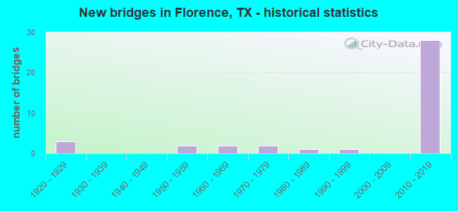
- New bridges - historical statistics
- 31920-1929
- 21950-1959
- 21960-1969
- 21970-1979
- 11980-1989
- 11990-1999
- 282010-2019

- Reconstructed bridges - Historical Statistics
- 11950-1959
- 01960-1969
- 01970-1979
- 11980-1989
- 21990-1999
- 12000-2009
- 02010-2019
- 22020-2022


- Bridge Condition - Deck
- 7.1%Very good
- 64.3%Good
- 28.6%Satisfactory

- Bridge Condition - Superstructure
- 50.0%Very good
- 35.7%Good
- 14.3%Satisfactory

- Bridge Condition - Substructure
- 7.1%Very good
- 71.4%Good
- 21.4%Satisfactory

- Bridge Condition - Channel
- 8.7%Very good
- 60.9%Good
- 30.4%Satisfactory

- Bridge Condition - Culverts
- 87.5%Good
- 12.5%Satisfactory
Find on map >> Show street view
Structure Number: 142460044001004, Location: 0.30 MI W OF SH 195 (Lat: 30.851964, Lng: -97.805611), Route carried "on" structure: State highway 138, Year Built: 1923, Year Reconstructed: 2020, Status: Open, Structure Length: 0.98m (3.22ft), Average Daily Traffic: 4,170 (year 2020), Truck Traffic: 5%, Average Future Daily Traffic: 6,299 (year 2039), Features Intersected: S SALADO CREEK
Minimum Vertical Clearance: 30+ m (98+ ft), Kilometerpoint: 12.099, Lanes on structure: 2, Owner: State Highway Agency, Approaching Roadway Width: 7.9m (25.9ft), Material/Design: Concrete, Design/Construction: Culvert, Number Of Spans In Main Unit: 3, Length of Maximum Span: 3.0m (9.8ft), Curb-To-Curb Width: 14.4m (47.2ft), Out-to-Out Width: 15.0m (49.2ft)
Condition: Channel: Good, Culverts: Satisfactory, Operating Rating: 32.7 metric tons, Method Used To Determine Operating Rating: Field evaluation and documented engineering judgment, Inventory Rating: 24.5 metric tons, Method Used To Determine Inventory Rating: Field evaluation and documented engineering judgment, Structural Evaluation: Equal to present minimum criteria, Deck Geometry: Superior to present desirable criteria, Waterway Adequacy: Equal to present minimum criteria, Approach Roadway Alignment: Equal to present desirable criteria, Length Of Structure Improvement: 0.98m (3.22ft), Designated Inspection Frequency: Every 24 months, Inspection Date: Febuary 2021, Bridge Improvement Cost: $2,000, Roadway Improvement Cost: $1,000, Total Project Cost: $3,000, Deck Structure Type: Concrete Cast-file-Place, Wearing Surface/Protective System: Wearing Surface: Bituminous
Find on map >> Show street view
Structure Number: 142460044001005, Location: 0.2 MI S OF FM 970 (Lat: 30.833436, Lng: -97.789972), Route carried "on" structure: Business State highway 195, Year Built: 1926, Year Reconstructed: 1958, Status: Open, Structure Length: 4.02m (13.19ft), Average Daily Traffic: 11,410 (year 2013), Truck Traffic: 13%, Average Future Daily Traffic: 15,970 (year 2033), Design Load: H 15, Features Intersected: S SALADO CREEK
Minimum Vertical Clearance: 30+ m (98+ ft), Kilometerpoint: 34.620, Lanes on structure: 2, Owner: State Highway Agency, Approaching Roadway Width: 13.4m (44.0ft), Material/Design: Concrete, Design/Construction: Tee Beam, Number Of Spans In Main Unit: 4, Length of Maximum Span: 10.1m (33.1ft), Curb-To-Curb Width: 13.2m (43.3ft), Out-to-Out Width: 14.0m (45.9ft)
Condition: Deck: Satisfactory, Superstructure: Satisfactory, Substructure: Satisfactory, Channel: Satisfactory, Operating Rating: 44.4 metric tons, Method Used To Determine Operating Rating: Load Factor (LF), Inventory Rating: 30.8 metric tons, Method Used To Determine Inventory Rating: Load Factor (LF), Structural Evaluation: Equal to present minimum criteria, Deck Geometry: Somewhat better than minimum adequacy, Waterway Adequacy: Equal to present minimum criteria, Approach Roadway Alignment: Equal to present desirable criteria, Designated Inspection Frequency: Every 24 months, Inspection Date: January 2021, Deck Structure Type: Concrete Cast-file-Place, Wearing Surface/Protective System: Wearing Surface: Bituminous
Find on map >> Show street view
Structure Number: 142460044001006, Location: 0.85 MI SE OF FM 970 (Lat: 30.824875, Lng: -97.783144), Route carried "on" structure: Business State highway 195, Year Built: 1926, Year Reconstructed: 2013, Status: Open, Structure Length: 0.64m (2.10ft), Average Daily Traffic: 11,410 (year 2013), Truck Traffic: 13%, Average Future Daily Traffic: 15,970 (year 2033), Features Intersected: DRAW
Minimum Vertical Clearance: 30+ m (98+ ft), Kilometerpoint: 35.801, Lanes on structure: 3, Owner: State Highway Agency, Approaching Roadway Width: 16.8m (55.1ft), Skew: 1 degrees, Material/Design: Concrete, Design/Construction: Culvert, Number Of Spans In Main Unit: 2, Length of Maximum Span: 3.0m (9.8ft), Curb-To-Curb Width: 16.8m (55.1ft), Out-to-Out Width: 28.7m (94.2ft)
Condition: Channel: Satisfactory, Culverts: Good, Operating Rating: 32.7 metric tons, Method Used To Determine Operating Rating: Field evaluation and documented engineering judgment, Inventory Rating: 24.5 metric tons, Method Used To Determine Inventory Rating: Field evaluation and documented engineering judgment, Structural Evaluation: Equal to present minimum criteria, Deck Geometry: Superior to present desirable criteria, Waterway Adequacy: Equal to present minimum criteria, Approach Roadway Alignment: Equal to present desirable criteria, Designated Inspection Frequency: Every 24 months, Inspection Date: January 2021, Deck Structure Type: Concrete Cast-file-Place, Wearing Surface/Protective System: Wearing Surface: Bituminous
Find on map >> Show street view
Structure Number: 142460044001238, Location: INT OF SH 138/SH 195 (Lat: 30.855556, Lng: -97.793611), Route carried "on" structure: State highway 138, Year Built: 2014, Status: Open, Structure Length: 9.45m (31.00ft), Average Daily Traffic: 1,978 (year 2020), Truck Traffic: 10%, Average Future Daily Traffic: 2,000 (year 2032), Design Load: HS 20, Features Intersected: SH 195
Minimum Vertical Clearance: 30+ m (98+ ft), Kilometerpoint: 1.213, Lanes on structure: 2, Lanes under structure: 4, Owner: State Highway Agency, Approaching Roadway Width: 12.2m (40.0ft), Material/Design: Prestressed concrete, Design/Construction: Stringer/Multi-beam, Number Of Spans In Main Unit: 2, Number Of Approach Spans: 2, Length of Maximum Span: 30.5m (100.1ft), Curb-To-Curb Width: 13.2m (43.3ft), Out-to-Out Width: 14.0m (45.9ft)
Condition: Deck: Good, Superstructure: Very good, Substructure: Good, Operating Rating: 54.4 metric tons, Method Used To Determine Operating Rating: Assigned rating based on Load Factor Design (LFD) reported in metric tons, Inventory Rating: 32.7 metric tons, Method Used To Determine Inventory Rating: Assigned rating based on Load Factor Design (LFD) reported in metric tons, Structural Evaluation: Better than present minimum criteria, Deck Geometry: Better than present minimum criteria, Underclear: Superior to present desirable criteria, Approach Roadway Alignment: Equal to present desirable criteria, Length Of Structure Improvement: 9.45m (31.00ft), Designated Inspection Frequency: Every 24 months, Inspection Date: January 2021, Deck Structure Type: Concrete Cast-file-Place
Find on map >> Show street view
Structure Number: 142460044001239, Location: AT FM 487 INTERSECTION (Lat: 30.843525, Lng: -97.785486), Route carried "on" structure: State highway 195, Year Built: 2014, Status: Open, Structure Length: 9.14m (29.99ft), Average Daily Traffic: 1,485 (year 2020), Truck Traffic: 12%, Average Future Daily Traffic: 10,000 (year 2032), Design Load: HS 20, Features Intersected: FM 487
Minimum Vertical Clearance: 30+ m (98+ ft), Kilometerpoint: 33.635, Lanes on structure: 2, Lanes under structure: 5, Owner: State Highway Agency, Approaching Roadway Width: 11.6m (38.1ft), Material/Design: Prestressed concrete, Design/Construction: Stringer/Multi-beam, Number Of Spans In Main Unit: 3, Length of Maximum Span: 30.5m (100.1ft), Curb-To-Curb Width: 11.3m (37.1ft), Out-to-Out Width: 12.2m (40.0ft)
Condition: Deck: Good, Superstructure: Very good, Substructure: Good, Operating Rating: 54.4 metric tons, Method Used To Determine Operating Rating: Assigned rating based on Load Factor Design (LFD) reported in metric tons, Inventory Rating: 32.7 metric tons, Method Used To Determine Inventory Rating: Assigned rating based on Load Factor Design (LFD) reported in metric tons, Structural Evaluation: Better than present minimum criteria, Deck Geometry: Equal to present minimum criteria, Underclear: Better than present minimum criteria, Approach Roadway Alignment: Equal to present desirable criteria, Designated Inspection Frequency: Every 24 months, Inspection Date: January 2021, Deck Structure Type: Concrete Cast-file-Place
Find on map >> Show street view
Structure Number: 14246004400124, Location: AT FM 487 INTERSECTION (Lat: 30.844167, Lng: -97.786389), Route carried "on" structure: State highway 195, Year Built: 2014, Status: Open, Structure Length: 9.14m (29.99ft), Average Daily Traffic: 5,000 (year 2012), Truck Traffic: 12%, Average Future Daily Traffic: 10,000 (year 2032), Design Load: HS 20, Features Intersected: FM 487
Minimum Vertical Clearance: 30+ m (98+ ft), Kilometerpoint: 33.635, Lanes on structure: 2, Lanes under structure: 5, Owner: State Highway Agency, Approaching Roadway Width: 11.6m (38.1ft), Material/Design: Prestressed concrete, Design/Construction: Stringer/Multi-beam, Number Of Spans In Main Unit: 3, Length of Maximum Span: 30.5m (100.1ft), Curb-To-Curb Width: 11.3m (37.1ft), Out-to-Out Width: 12.2m (40.0ft)
Condition: Deck: Good, Superstructure: Very good, Substructure: Good, Operating Rating: 54.4 metric tons, Method Used To Determine Operating Rating: Assigned rating based on Load Factor Design (LFD) reported in metric tons, Inventory Rating: 32.7 metric tons, Method Used To Determine Inventory Rating: Assigned rating based on Load Factor Design (LFD) reported in metric tons, Structural Evaluation: Better than present minimum criteria, Deck Geometry: Equal to present minimum criteria, Underclear: Better than present minimum criteria, Approach Roadway Alignment: Equal to present desirable criteria, Designated Inspection Frequency: Every 24 months, Inspection Date: January 2021, Deck Structure Type: Concrete Cast-file-Place
Find on map >> Show street view
Structure Number: 142460044001242, Location: 1.4 MI SE OF FM 970 (Lat: 30.817283, Lng: -97.777472), Route carried "on" structure: State highway 195, Year Built: 2013, Status: Open, Structure Length: 1.10m (3.61ft), Average Daily Traffic: 10,300 (year 2009), Truck Traffic: 12%, Average Future Daily Traffic: 18,330 (year 2027), Design Load: HL 93, Features Intersected: DRAW
Minimum Vertical Clearance: 30+ m (98+ ft), Kilometerpoint: 36.735, Lanes on structure: 4, Owner: State Highway Agency, Approaching Roadway Width: 23.2m (76.1ft), Material/Design: Concrete, Design/Construction: Culvert, Number Of Spans In Main Unit: 3, Length of Maximum Span: 3.0m (9.8ft), Curb-To-Curb Width: 23.2m (76.1ft), Out-to-Out Width: 59.1m (193.9ft)
Condition: Channel: Good, Culverts: Good, Operating Rating: 44.4 metric tons, Method Used To Determine Operating Rating: Assigned ratings based on Load and Resistance Factor Design (LRFD) reported in metric tons, Inventory Rating: 32.7 metric tons, Method Used To Determine Inventory Rating: Assigned ratings based on Load and Resistance Factor Design (LRFD) reported in metric tons, Structural Evaluation: Better than present minimum criteria, Deck Geometry: Superior to present desirable criteria, Waterway Adequacy: Superior to present desirable criteria, Approach Roadway Alignment: Equal to present desirable criteria, Designated Inspection Frequency: Every 48 months, Inspection Date: March 2021, Deck Structure Type: Concrete Cast-file-Place, Wearing Surface/Protective System: Wearing Surface: Bituminous
Find on map >> Show street view
Structure Number: 142460044001243, Location: 1.9 MI SE OF FM 970 (Lat: 30.810939, Lng: -97.772981), Route carried "on" structure: State highway 195, Year Built: 2013, Status: Open, Structure Length: 0.98m (3.22ft), Average Daily Traffic: 10,300 (year 2010), Truck Traffic: 12%, Average Future Daily Traffic: 18,330 (year 2027), Design Load: HL 93, Features Intersected: DRAW
Minimum Vertical Clearance: 30+ m (98+ ft), Kilometerpoint: 37.552, Lanes on structure: 4, Owner: State Highway Agency, Approaching Roadway Width: 36.9m (121.1ft), Skew: 4 degrees, Material/Design: Concrete, Design/Construction: Culvert, Number Of Spans In Main Unit: 2, Length of Maximum Span: 3.0m (9.8ft), Curb-To-Curb Width: 36.9m (121.1ft), Out-to-Out Width: 57.9m (190.0ft)
Condition: Channel: Good, Culverts: Good, Operating Rating: 44.4 metric tons, Method Used To Determine Operating Rating: Assigned ratings based on Load and Resistance Factor Design (LRFD) reported in metric tons, Inventory Rating: 32.7 metric tons, Method Used To Determine Inventory Rating: Assigned ratings based on Load and Resistance Factor Design (LRFD) reported in metric tons, Structural Evaluation: Better than present minimum criteria, Deck Geometry: Superior to present desirable criteria, Waterway Adequacy: Superior to present desirable criteria, Approach Roadway Alignment: Equal to present desirable criteria, Designated Inspection Frequency: Every 48 months, Inspection Date: March 2021, Deck Structure Type: Concrete Cast-file-Place, Wearing Surface/Protective System: Wearing Surface: Bituminous
Find on map >> Show street view
Structure Number: 142460044001244, Location: 1.2 MI S OF FM 487 (Lat: 30.822717, Lng: -97.780808), Route carried "on" structure: State highway 195, Year Built: 2014, Status: Open, Structure Length: 53.31m (174.90ft), Average Daily Traffic: 5,000 (year 2012), Truck Traffic: 12%, Average Future Daily Traffic: 10,000 (year 2032), Design Load: HS 20, Features Intersected: SOUTH SALADO CREEK
Minimum Vertical Clearance: 30+ m (98+ ft), Kilometerpoint: 35.727, Lanes on structure: 2, Lanes under structure: 3, Owner: State Highway Agency, Approaching Roadway Width: 11.6m (38.1ft), Skew: 9 degrees, Material/Design: Prestressed concrete, Design/Construction: Stringer/Multi-beam, Number Of Spans In Main Unit: 15, Length of Maximum Span: 36.9m (121.1ft), Curb-To-Curb Width: 11.3m (37.1ft), Out-to-Out Width: 12.2m (40.0ft)
Condition: Deck: Good, Superstructure: Very good, Substructure: Good, Channel: Good, Operating Rating: 54.4 metric tons, Method Used To Determine Operating Rating: Assigned rating based on Load Factor Design (LFD) reported in metric tons, Inventory Rating: 32.7 metric tons, Method Used To Determine Inventory Rating: Assigned rating based on Load Factor Design (LFD) reported in metric tons, Structural Evaluation: Better than present minimum criteria, Deck Geometry: Equal to present minimum criteria, Underclear: Equal to present desirable criteria, Waterway Adequacy: Superior to present desirable criteria, Approach Roadway Alignment: Equal to present desirable criteria, Designated Inspection Frequency: Every 24 months, Inspection Date: January 2021, Deck Structure Type: Concrete Cast-file-Place
Find on map >> Show street view
Structure Number: 142460044001245, Location: 1.2 MI S OF FM 487 (Lat: 30.827647, Lng: -97.781836), Route carried "on" structure: State highway 195, Year Built: 2014, Status: Open, Structure Length: 52.79m (173.20ft), Average Daily Traffic: 5,000 (year 2012), Truck Traffic: 12%, Average Future Daily Traffic: 10,000 (year 2032), Design Load: HS 20, Features Intersected: SOUTH SALADO CREEK
Minimum Vertical Clearance: 30+ m (98+ ft), Kilometerpoint: 35.727, Lanes on structure: 2, Lanes under structure: 3, Owner: State Highway Agency, Approaching Roadway Width: 11.6m (38.1ft), Skew: 9 degrees, Material/Design: Prestressed concrete, Design/Construction: Stringer/Multi-beam, Number Of Spans In Main Unit: 15, Length of Maximum Span: 36.3m (119.1ft), Curb-To-Curb Width: 11.3m (37.1ft), Out-to-Out Width: 12.2m (40.0ft)
Condition: Deck: Good, Superstructure: Very good, Substructure: Good, Channel: Good, Operating Rating: 54.4 metric tons, Method Used To Determine Operating Rating: Assigned rating based on Load Factor Design (LFD) reported in metric tons, Inventory Rating: 32.7 metric tons, Method Used To Determine Inventory Rating: Assigned rating based on Load Factor Design (LFD) reported in metric tons, Structural Evaluation: Better than present minimum criteria, Deck Geometry: Equal to present minimum criteria, Underclear: Equal to present minimum criteria, Waterway Adequacy: Superior to present desirable criteria, Approach Roadway Alignment: Equal to present desirable criteria, Designated Inspection Frequency: Every 24 months, Inspection Date: January 2021, Deck Structure Type: Concrete Cast-file-Place
Find on map >> Show street view
Structure Number: 142460044001246, Location: 0.02 MI E OF SH 195 BUS (Lat: 30.827261, Lng: -97.784367), Route carried "on" structure: State highway 195, Year Built: 2014, Status: Open, Structure Length: 12.19m (39.99ft), Average Daily Traffic: 1,654 (year 2020), Truck Traffic: 12%, Average Future Daily Traffic: 500 (year 2032), Design Load: HS 20, Features Intersected: SOUTH SALADO CREEK
Minimum Vertical Clearance: 30+ m (98+ ft), Kilometerpoint: 35.406, Lanes on structure: 2, Owner: State Highway Agency, Approaching Roadway Width: 13.4m (44.0ft), Material/Design: Prestressed concrete, Design/Construction: Box Beam or Girders - Multiple, Number Of Spans In Main Unit: 8, Length of Maximum Span: 15.2m (49.9ft), Curb-To-Curb Width: 13.2m (43.3ft), Out-to-Out Width: 14.0m (45.9ft)
Condition: Deck: Good, Superstructure: Very good, Substructure: Very good, Channel: Good, Operating Rating: 54.4 metric tons, Method Used To Determine Operating Rating: Assigned rating based on Load Factor Design (LFD) reported in metric tons, Inventory Rating: 32.7 metric tons, Method Used To Determine Inventory Rating: Assigned rating based on Load Factor Design (LFD) reported in metric tons, Structural Evaluation: Equal to present desirable criteria, Deck Geometry: Better than present minimum criteria, Waterway Adequacy: Superior to present desirable criteria, Approach Roadway Alignment: Equal to present desirable criteria, Designated Inspection Frequency: Every 24 months, Inspection Date: January 2021, Deck Structure Type: Concrete Cast-file-Place
Find on map >> Show street view
Structure Number: 14246004400127, Location: 2.7 MI SE OF FM 970 (Lat: 30.801892, Lng: -97.768689), Route carried "on" structure: State highway 195, Year Built: 2015, Status: Open, Structure Length: 0.70m (2.30ft), Average Daily Traffic: 14,600 (year 2015), Truck Traffic: 10%, Average Future Daily Traffic: 22,700 (year 2035), Design Load: HL 93, Features Intersected: DRAW
Minimum Vertical Clearance: 30+ m (98+ ft), Kilometerpoint: 38.724, Lanes on structure: 5, Owner: State Highway Agency, Approaching Roadway Width: 32.3m (106.0ft), Material/Design: Concrete, Design/Construction: Culvert, Number Of Spans In Main Unit: 2, Length of Maximum Span: 3.0m (9.8ft), Curb-To-Curb Width: 32.3m (106.0ft), Out-to-Out Width: 58.5m (191.9ft)
Condition: Channel: Very good, Culverts: Good, Operating Rating: 54.4 metric tons, Method Used To Determine Operating Rating: Assigned ratings based on Load and Resistance Factor Design (LRFD) reported in metric tons, Inventory Rating: 32.7 metric tons, Method Used To Determine Inventory Rating: Assigned ratings based on Load and Resistance Factor Design (LRFD) reported in metric tons, Structural Evaluation: Better than present minimum criteria, Deck Geometry: Superior to present desirable criteria, Waterway Adequacy: Superior to present desirable criteria, Approach Roadway Alignment: Equal to present desirable criteria, Designated Inspection Frequency: Every 24 months, Inspection Date: January 2021, Deck Structure Type: Concrete Cast-file-Place, Wearing Surface/Protective System: Wearing Surface: Bituminous
Find on map >> Show street view
Structure Number: 142460083601008, Location: 0.94 MI N OF SH 138 (Lat: 30.869081, Lng: -97.795561), Route carried "on" structure: State highway 195, Year Built: 2015, Status: Open, Structure Length: 6.71m (22.01ft), Average Daily Traffic: 10,586 (year 2020), Truck Traffic: 5%, Average Future Daily Traffic: 18,330 (year 2027), Design Load: HS 20, Features Intersected: CR 228
Minimum Vertical Clearance: 30+ m (98+ ft), Kilometerpoint: 1.448, Lanes on structure: 2, Lanes under structure: 2, Base Highway Network: Yes, Owner: State Highway Agency, Approaching Roadway Width: 11.6m (38.1ft), Skew: 19 degrees, Material/Design: Prestressed concrete, Design/Construction: Stringer/Multi-beam, Number Of Spans In Main Unit: 3, Length of Maximum Span: 25.9m (85.0ft), Curb-To-Curb Width: 11.6m (38.1ft), Out-to-Out Width: 12.2m (40.0ft)
Condition: Deck: Good, Superstructure: Very good, Substructure: Good, Operating Rating: 54.4 metric tons, Method Used To Determine Operating Rating: Assigned rating based on Load Factor Design (LFD) reported in metric tons, Inventory Rating: 32.7 metric tons, Method Used To Determine Inventory Rating: Assigned rating based on Load Factor Design (LFD) reported in metric tons, Structural Evaluation: Better than present minimum criteria, Deck Geometry: Better than present minimum criteria, Underclear: Superior to present desirable criteria, Approach Roadway Alignment: Equal to present desirable criteria, Designated Inspection Frequency: Every 24 months, Inspection Date: March 2021, Deck Structure Type: Concrete Cast-file-Place
Find on map >> Show street view
Structure Number: 142460083601094, Location: 1.4 MI N OF SH138 (Lat: 30.875439, Lng: -97.797889), Route carried "on" structure: State highway 195, Year Built: 2015, Status: Open, Structure Length: 10.97m (35.99ft), Average Daily Traffic: 10,586 (year 2020), Truck Traffic: 5%, Average Future Daily Traffic: 10,000 (year 2027), Design Load: HS 20, Features Intersected: SH 195 CONNECTOR A
Minimum Vertical Clearance: 30+ m (98+ ft), Kilometerpoint: 2.253, Lanes on structure: 2, Lanes under structure: 1, Base Highway Network: Yes, Owner: State Highway Agency, Approaching Roadway Width: 11.6m (38.1ft), Skew: 14 degrees, Material/Design: Prestressed concrete, Design/Construction: Stringer/Multi-beam, Number Of Spans In Main Unit: 3, Length of Maximum Span: 36.6m (120.1ft), Curb-To-Curb Width: 11.6m (38.1ft), Out-to-Out Width: 12.2m (40.0ft)
Condition: Deck: Satisfactory, Superstructure: Good, Substructure: Good, Operating Rating: 54.4 metric tons, Method Used To Determine Operating Rating: Assigned rating based on Load Factor Design (LFD) reported in metric tons, Inventory Rating: 32.7 metric tons, Method Used To Determine Inventory Rating: Assigned rating based on Load Factor Design (LFD) reported in metric tons, Structural Evaluation: Better than present minimum criteria, Deck Geometry: Better than present minimum criteria, Underclear: Superior to present desirable criteria, Approach Roadway Alignment: Equal to present desirable criteria, Designated Inspection Frequency: Every 24 months, Inspection Date: March 2021, Deck Structure Type: Concrete Cast-file-Place
Find on map >> Show street view
Structure Number: 142460083601095, Location: 1.4 MI N OF SH 138 (Lat: 30.875439, Lng: -97.797889), Route carried "on" structure: State highway 195, Year Built: 2015, Status: Open, Structure Length: 10.97m (35.99ft), Average Daily Traffic: 10,284 (year 2020), Truck Traffic: 5%, Average Future Daily Traffic: 18,330 (year 2027), Design Load: HS 20, Features Intersected: SH 195 CONNECTOR A
Minimum Vertical Clearance: 30+ m (98+ ft), Kilometerpoint: 2.253, Lanes on structure: 2, Lanes under structure: 1, Base Highway Network: Yes, Owner: State Highway Agency, Approaching Roadway Width: 11.6m (38.1ft), Skew: 4 degrees, Material/Design: Prestressed concrete, Design/Construction: Stringer/Multi-beam, Number Of Spans In Main Unit: 3, Length of Maximum Span: 36.6m (120.1ft), Curb-To-Curb Width: 11.6m (38.1ft), Out-to-Out Width: 12.2m (40.0ft)
Condition: Deck: Satisfactory, Superstructure: Good, Substructure: Good, Operating Rating: 54.4 metric tons, Method Used To Determine Operating Rating: Assigned rating based on Load Factor Design (LFD) reported in metric tons, Inventory Rating: 32.7 metric tons, Method Used To Determine Inventory Rating: Assigned rating based on Load Factor Design (LFD) reported in metric tons, Structural Evaluation: Better than present minimum criteria, Deck Geometry: Better than present minimum criteria, Underclear: Superior to present desirable criteria, Approach Roadway Alignment: Equal to present desirable criteria, Designated Inspection Frequency: Every 24 months, Inspection Date: March 2021, Deck Structure Type: Concrete Cast-file-Place
Find on map >> Show street view
Structure Number: 142460083601096, Location: 0.94 MI N OF SH 138 (Lat: 30.868919, Lng: -97.795861), Route carried "on" structure: State highway 195, Year Built: 2015, Status: Open, Structure Length: 6.74m (22.11ft), Average Daily Traffic: 10,284 (year 2020), Truck Traffic: 5%, Average Future Daily Traffic: 18,330 (year 2027), Design Load: HS 20, Features Intersected: CR 228
Minimum Vertical Clearance: 30+ m (98+ ft), Kilometerpoint: 1.513, Lanes on structure: 2, Lanes under structure: 2, Base Highway Network: Yes, Owner: State Highway Agency, Approaching Roadway Width: 11.6m (38.1ft), Skew: 39 degrees, Material/Design: Prestressed concrete, Design/Construction: Stringer/Multi-beam, Number Of Spans In Main Unit: 2, Number Of Approach Spans: 1, Length of Maximum Span: 25.9m (85.0ft), Curb-To-Curb Width: 11.6m (38.1ft), Out-to-Out Width: 12.2m (40.0ft)
Condition: Deck: Good, Superstructure: Good, Substructure: Good, Operating Rating: 54.4 metric tons, Method Used To Determine Operating Rating: Assigned rating based on Load Factor Design (LFD) reported in metric tons, Inventory Rating: 32.7 metric tons, Method Used To Determine Inventory Rating: Assigned rating based on Load Factor Design (LFD) reported in metric tons, Structural Evaluation: Better than present minimum criteria, Deck Geometry: Better than present minimum criteria, Underclear: Superior to present desirable criteria, Approach Roadway Alignment: Equal to present desirable criteria, Designated Inspection Frequency: Every 24 months, Inspection Date: March 2021, Deck Structure Type: Concrete Cast-file-Place
Find on map >> Show street view
Structure Number: 142460083601097, Location: 1.9 MI N OF SH 138 (Lat: 30.878672, Lng: -97.798728), Route carried "on" structure: State highway 195, Year Built: 2013, Status: Open, Structure Length: 1.16m (3.81ft), Average Daily Traffic: 20,871 (year 2020), Truck Traffic: 17%, Average Future Daily Traffic: 18,330 (year 2027), Design Load: HL 93, Features Intersected: ROCKY CREEK
Minimum Vertical Clearance: 30+ m (98+ ft), Kilometerpoint: 5.028, Lanes on structure: 5, Owner: State Highway Agency, Approaching Roadway Width: 35.4m (116.1ft), Skew: 3 degrees, Material/Design: Concrete, Design/Construction: Culvert, Number Of Spans In Main Unit: 3, Length of Maximum Span: 2.7m (8.9ft)
Condition: Channel: Good, Culverts: Good, Operating Rating: 44.4 metric tons, Method Used To Determine Operating Rating: Assigned ratings based on Load and Resistance Factor Design (LRFD) reported in metric tons, Inventory Rating: 32.7 metric tons, Method Used To Determine Inventory Rating: Assigned ratings based on Load and Resistance Factor Design (LRFD) reported in metric tons, Structural Evaluation: Better than present minimum criteria, Waterway Adequacy: Superior to present desirable criteria, Approach Roadway Alignment: Equal to present desirable criteria, Designated Inspection Frequency: Every 48 months, Inspection Date: March 2021
Find on map >> Show street view
Structure Number: 142460083601098, Location: 0.9 MI N OF SH 138 (Lat: 30.872136, Lng: -97.796181), Route carried "on" structure: State highway 195, Year Built: 2015, Status: Open, Structure Length: 0.64m (2.10ft), Average Daily Traffic: 20,871 (year 2020), Truck Traffic: 5%, Average Future Daily Traffic: 18,330 (year 2027), Design Load: HL 93, Features Intersected: DRAW
Minimum Vertical Clearance: 30+ m (98+ ft), Kilometerpoint: 1.448, Lanes on structure: 4, Base Highway Network: Yes, Owner: State Highway Agency, Approaching Roadway Width: 27.4m (89.9ft), Skew: 31 degrees, Material/Design: Concrete, Design/Construction: Culvert, Number Of Spans In Main Unit: 2, Length of Maximum Span: 3.0m (9.8ft)
Condition: Channel: Satisfactory, Culverts: Good, Operating Rating: 54.4 metric tons, Method Used To Determine Operating Rating: Assigned ratings based on Load and Resistance Factor Design (LRFD) reported in metric tons, Inventory Rating: 32.7 metric tons, Method Used To Determine Inventory Rating: Assigned ratings based on Load and Resistance Factor Design (LRFD) reported in metric tons, Structural Evaluation: Better than present minimum criteria, Waterway Adequacy: Equal to present desirable criteria, Approach Roadway Alignment: Equal to present desirable criteria, Designated Inspection Frequency: Every 24 months, Inspection Date: March 2021, Deck Structure Type: Concrete Cast-file-Place, Wearing Surface/Protective System: Wearing Surface: Bituminous
Find on map >> Show street view
Structure Number: 142460083601099, Location: 1.65 MI N OF SH 138 (Lat: 30.878531, Lng: -97.797511), Route carried "on" structure: State highway 195, Year Built: 2014, Status: Open, Structure Length: 1.43m (4.69ft), Average Daily Traffic: 20,871 (year 2020), Truck Traffic: 5%, Average Future Daily Traffic: 18,500 (year 2034), Design Load: HL 93, Features Intersected: DRAW
Minimum Vertical Clearance: 30+ m (98+ ft), Kilometerpoint: 2.689, Lanes on structure: 1, Owner: State Highway Agency, Approaching Roadway Width: 8.5m (27.9ft), Skew: 4 degrees, Material/Design: Concrete, Design/Construction: Culvert, Number Of Spans In Main Unit: 3, Length of Maximum Span: 2.7m (8.9ft)
Condition: Channel: Very good, Culverts: Good, Operating Rating: 54.4 metric tons, Method Used To Determine Operating Rating: Assigned ratings based on Load and Resistance Factor Design (LRFD) reported in metric tons, Inventory Rating: 32.7 metric tons, Method Used To Determine Inventory Rating: Assigned ratings based on Load and Resistance Factor Design (LRFD) reported in metric tons, Structural Evaluation: Better than present minimum criteria, Waterway Adequacy: Superior to present desirable criteria, Approach Roadway Alignment: Equal to present desirable criteria, Designated Inspection Frequency: Every 24 months, Inspection Date: January 2021
Find on map >> Show street view
Structure Number: 142460120101014, Location: 0.05 MI SW OF SH 195 (Lat: 30.834906, Lng: -97.791744), Route carried "on" structure: State highway 970, Year Built: 1961, Status: Open, Structure Length: 3.35m (10.99ft), Average Daily Traffic: 1,416 (year 2020), Truck Traffic: 9%, Average Future Daily Traffic: 2,400 (year 2033), Design Load: H 15, Features Intersected: SOUTH SALADO CREEK
Minimum Vertical Clearance: 30+ m (98+ ft), Kilometerpoint: 12.925, Lanes on structure: 2, Owner: State Highway Agency, Approaching Roadway Width: 7.3m (24.0ft), Material/Design: Concrete continuous, Design/Construction: Slab, Number Of Spans In Main Unit: 4, Length of Maximum Span: 9.1m (29.9ft), Curb-To-Curb Width: 9.3m (30.5ft), Out-to-Out Width: 9.8m (32.2ft)
Condition: Deck: Satisfactory, Superstructure: Satisfactory, Substructure: Satisfactory, Channel: Satisfactory, Operating Rating: 40.8 metric tons, Method Used To Determine Operating Rating: Load Factor (LF), Inventory Rating: 24.5 metric tons, Method Used To Determine Inventory Rating: Load Factor (LF), Structural Evaluation: Equal to present minimum criteria, Deck Geometry: Somewhat better than minimum adequacy, Waterway Adequacy: Equal to present minimum criteria, Approach Roadway Alignment: Equal to present desirable criteria, Length Of Structure Improvement: 3.35m (10.99ft), Designated Inspection Frequency: Every 24 months, Inspection Date: January 2021, Bridge Improvement Cost: $7,000, Roadway Improvement Cost: $2,000, Total Project Cost: $9,000, Deck Structure Type: Concrete Cast-file-Place, Wearing Surface/Protective System: Wearing Surface: Bituminous
Find on map >> Show street view
Structure Number: 142460120101015, Location: 4.85 MI NE OF US 183 (Lat: 30.810750, Lng: -97.825900), Route carried "on" structure: State highway 970, Year Built: 1962, Status: Open, Structure Length: 3.81m (12.50ft), Average Daily Traffic: 883 (year 2020), Truck Traffic: 9%, Average Future Daily Traffic: 1,051 (year 2039), Design Load: H 15, Features Intersected: BERRY CREEK
Minimum Vertical Clearance: 30+ m (98+ ft), Kilometerpoint: 7.866, Lanes on structure: 2, Owner: State Highway Agency, Approaching Roadway Width: 7.3m (24.0ft), Material/Design: Concrete, Design/Construction: Slab, Number Of Spans In Main Unit: 5, Length of Maximum Span: 7.6m (24.9ft), Curb-To-Curb Width: 7.1m (23.3ft), Out-to-Out Width: 7.7m (25.3ft)
Condition: Deck: Good, Superstructure: Good, Substructure: Satisfactory, Channel: Good, Operating Rating: 44.4 metric tons, Method Used To Determine Operating Rating: Load Factor (LF), Inventory Rating: 26.3 metric tons, Method Used To Determine Inventory Rating: Load Factor (LF), Structural Evaluation: Equal to present minimum criteria, Deck Geometry: Meets minimum limits, Waterway Adequacy: Equal to present minimum criteria, Approach Roadway Alignment: Equal to present desirable criteria, Length Of Structure Improvement: 3.81m (12.50ft), Designated Inspection Frequency: Every 24 months, Inspection Date: Febuary 2021, Bridge Improvement Cost: $6,000, Roadway Improvement Cost: $2,000, Total Project Cost: $8,000, Deck Structure Type: Concrete Cast-file-Place, Wearing Surface/Protective System: Wearing Surface: Bituminous
Find on map >> Show street view
Structure Number: 142460120101253, Location: 2.65 MI SW OF SH 195 BUS (Lat: 30.813236, Lng: -97.817683), Route carried "on" structure: State highway 970, Year Built: 1950, Year Reconstructed: 2020, Status: Open, Structure Length: 0.91m (2.99ft), Average Daily Traffic: 883 (year 2020), Truck Traffic: 9%, Average Future Daily Traffic: 1,051 (year 2039), Design Load: H 15, Features Intersected: TRIB OF BERRY CR
Minimum Vertical Clearance: 30+ m (98+ ft), Kilometerpoint: 8.707, Lanes on structure: 2, Owner: State Highway Agency, Approaching Roadway Width: 7.3m (24.0ft), Skew: 4 degrees, Material/Design: Concrete, Design/Construction: Culvert, Number Of Spans In Main Unit: 3, Length of Maximum Span: 1.5m (4.9ft), Curb-To-Curb Width: 11.2m (36.7ft), Out-to-Out Width: 11.8m (38.7ft)
Condition: Channel: Good, Culverts: Good, Operating Rating: 32.7 metric tons, Method Used To Determine Operating Rating: Field evaluation and documented engineering judgment, Inventory Rating: 24.5 metric tons, Method Used To Determine Inventory Rating: Field evaluation and documented engineering judgment, Structural Evaluation: Equal to present minimum criteria, Deck Geometry: Better than present minimum criteria, Waterway Adequacy: Equal to present minimum criteria, Approach Roadway Alignment: Equal to present desirable criteria, Designated Inspection Frequency: Every 24 months, Inspection Date: Febuary 2021, Deck Structure Type: Concrete Cast-file-Place, Wearing Surface/Protective System: Wearing Surface: Bituminous
Find on map >> Show street view
Structure Number: 142460120102008, Location: 0.30 MI E OF SH 195 (Lat: 30.842717, Lng: -97.789478), Route carried "on" structure: State highway 487, Year Built: 1955, Year Reconstructed: 1988, Status: Open, Structure Length: 1.07m (3.51ft), Average Daily Traffic: 2,790 (year 2020), Truck Traffic: 11%, Average Future Daily Traffic: 5,722 (year 2039), Features Intersected: DRAW
Minimum Vertical Clearance: 30+ m (98+ ft), Kilometerpoint: 16.544, Lanes on structure: 2, Owner: State Highway Agency, Approaching Roadway Width: 6.7m (22.0ft), Skew: 3 degrees, Material/Design: Concrete, Design/Construction: Culvert, Number Of Spans In Main Unit: 4, Length of Maximum Span: 2.1m (6.9ft), Curb-To-Curb Width: 12.1m (39.7ft), Out-to-Out Width: 16.4m (53.8ft)
Condition: Channel: Good, Culverts: Good, Operating Rating: 39.9 metric tons, Method Used To Determine Operating Rating: Load Factor (LF), Inventory Rating: 23.6 metric tons, Method Used To Determine Inventory Rating: Load Factor (LF), Structural Evaluation: Equal to present minimum criteria, Deck Geometry: Somewhat better than minimum adequacy, Waterway Adequacy: Equal to present minimum criteria, Approach Roadway Alignment: Equal to present desirable criteria, Length Of Structure Improvement: 1.04m (3.41ft), Designated Inspection Frequency: Every 24 months, Inspection Date: Febuary 2021, Bridge Improvement Cost: $1,000, Total Project Cost: $1,000, Deck Structure Type: Concrete Cast-file-Place, Wearing Surface/Protective System: Wearing Surface: Bituminous
Find on map >> Show street view
Structure Number: 142460120102247, Location: 0.1 Mi E of SH 195 (Lat: 30.844261, Lng: -97.784403), Route carried "on" structure: State highway 487, Year Built: 2013, Status: Open, Structure Length: 0.67m (2.20ft), Average Daily Traffic: 2,790 (year 2020), Truck Traffic: 18%, Average Future Daily Traffic: 3,040 (year 2030), Design Load: HL 93, Features Intersected: DRAINAGE DITCH
Minimum Vertical Clearance: 30+ m (98+ ft), Kilometerpoint: 17.027, Lanes on structure: 2, Owner: State Highway Agency, Approaching Roadway Width: 13.4m (44.0ft), Material/Design: Concrete, Design/Construction: Culvert, Number Of Spans In Main Unit: 2, Length of Maximum Span: 3.0m (9.8ft)
Condition: Channel: Good, Culverts: Good, Operating Rating: 44.4 metric tons, Method Used To Determine Operating Rating: Assigned ratings based on Load and Resistance Factor Design (LRFD) reported in metric tons, Inventory Rating: 32.7 metric tons, Method Used To Determine Inventory Rating: Assigned ratings based on Load and Resistance Factor Design (LRFD) reported in metric tons, Structural Evaluation: Better than present minimum criteria, Waterway Adequacy: Superior to present desirable criteria, Approach Roadway Alignment: Equal to present desirable criteria, Designated Inspection Frequency: Every 48 months, Inspection Date: March 2021
Find on map >> Show street view
Structure Number: 142460287002005, Location: 0.20 MI N OF FM 487 (Lat: 30.853731, Lng: -97.744636), Route carried "on" structure: State highway 2843, Year Built: 1972, Year Reconstructed: 1999, Status: Open, Structure Length: 0.76m (2.49ft), Average Daily Traffic: 1,460 (year 2020), Truck Traffic: 10%, Average Future Daily Traffic: 2,185 (year 2039), Design Load: HS 20, Features Intersected: N SALADO CREEK
Minimum Vertical Clearance: 30+ m (98+ ft), Kilometerpoint: 0.224, Lanes on structure: 2, Owner: State Highway Agency, Approaching Roadway Width: 11.0m (36.1ft), Skew: 3 degrees, Material/Design: Concrete, Design/Construction: Culvert, Number Of Spans In Main Unit: 2, Length of Maximum Span: 3.0m (9.8ft), Curb-To-Curb Width: 11.1m (36.4ft), Out-to-Out Width: 18.1m (59.4ft)
Condition: Channel: Satisfactory, Culverts: Good, Operating Rating: 39.9 metric tons, Method Used To Determine Operating Rating: Load Factor (LF), Inventory Rating: 23.6 metric tons, Method Used To Determine Inventory Rating: Load Factor (LF), Structural Evaluation: Equal to present minimum criteria, Deck Geometry: Equal to present minimum criteria, Waterway Adequacy: Better than present minimum criteria, Approach Roadway Alignment: Equal to present minimum criteria, Designated Inspection Frequency: Every 24 months, Inspection Date: March 2021, Deck Structure Type: Concrete Cast-file-Place, Wearing Surface/Protective System: Wearing Surface: Bituminous
Find on map >> Show street view
Structure Number: 142460287002006, Location: 0.90 MI N OF FM 487 (Lat: 30.862717, Lng: -97.741869), Route carried "on" structure: State highway 2843, Year Built: 1972, Year Reconstructed: 1999, Status: Open, Structure Length: 0.67m (2.20ft), Average Daily Traffic: 1,460 (year 2020), Truck Traffic: 10%, Average Future Daily Traffic: 2,185 (year 2039), Design Load: HS 20, Features Intersected: DRAW
Minimum Vertical Clearance: 30+ m (98+ ft), Kilometerpoint: 1.442, Lanes on structure: 2, Owner: State Highway Agency, Approaching Roadway Width: 10.4m (34.1ft), Material/Design: Concrete, Design/Construction: Culvert, Number Of Spans In Main Unit: 2, Length of Maximum Span: 3.0m (9.8ft), Curb-To-Curb Width: 15.9m (52.2ft), Out-to-Out Width: 16.4m (53.8ft)
Condition: Channel: Good, Culverts: Satisfactory, Operating Rating: 39.9 metric tons, Method Used To Determine Operating Rating: Load Factor (LF), Inventory Rating: 23.6 metric tons, Method Used To Determine Inventory Rating: Load Factor (LF), Structural Evaluation: Equal to present minimum criteria, Deck Geometry: Superior to present desirable criteria, Waterway Adequacy: Better than present minimum criteria, Approach Roadway Alignment: Equal to present desirable criteria, Designated Inspection Frequency: Every 24 months, Inspection Date: March 2021, Deck Structure Type: Concrete Cast-file-Place, Wearing Surface/Protective System: Wearing Surface: Bituminous
Find on map >> Show street view
Structure Number: 142460AA0133002, Location: 2.0 MI W OF FM 970 (Lat: 30.822675, Lng: -97.841881), Route carried "on" structure: County highway 219, Year Built: 1990, Status: Open, Structure Length: 4.57m (14.99ft), Average Daily Traffic: 300 (year 2010), Average Future Daily Traffic: 420 (year 2030), Design Load: HS 20, Features Intersected: BERRY CREEK
Minimum Vertical Clearance: 30+ m (98+ ft), Kilometerpoint: 3.380, Lanes on structure: 2, Owner: County Highway Agency, Approaching Roadway Width: 7.3m (24.0ft), Skew: 4 degrees, Material/Design: Prestressed concrete, Design/Construction: Stringer/Multi-beam, Number Of Spans In Main Unit: 3, Length of Maximum Span: 15.2m (49.9ft), Curb-To-Curb Width: 7.8m (25.6ft), Out-to-Out Width: 8.5m (27.9ft)
Condition: Deck: Very good, Superstructure: Good, Substructure: Good, Channel: Satisfactory, Operating Rating: 65.3 metric tons, Method Used To Determine Operating Rating: Assigned rating based on Load Factor Design (LFD) reported in metric tons, Inventory Rating: 39.0 metric tons, Method Used To Determine Inventory Rating: Assigned rating based on Load Factor Design (LFD) reported in metric tons, Structural Evaluation: Better than present minimum criteria, Deck Geometry: Somewhat better than minimum adequacy, Waterway Adequacy: Better than present minimum criteria, Approach Roadway Alignment: Equal to present minimum criteria, Designated Inspection Frequency: Every 24 months, Inspection Date: October 2021, Deck Structure Type: Concrete Cast-file-Place, Wearing Surface/Protective System: Wearing Surface: Bituminous
Find on map >> Show street view
Structure Number: 142460AA0144001, Location: 0.20 MI E OF SH 195 (Lat: 30.820817, Lng: -97.775089), Route carried "on" structure: County highway 233, Year Built: 1989, Status: Open, Structure Length: 2.29m (7.51ft), Average Daily Traffic: 138 (year 2020), Average Future Daily Traffic: 365 (year 2030), Features Intersected: SALADO CREEK
Minimum Vertical Clearance: 30+ m (98+ ft), Kilometerpoint: 7.966, Lanes on structure: 2, Owner: County Highway Agency, Approaching Roadway Width: 5.5m (18.0ft), Material/Design: Concrete, Design/Construction: Culvert, Number Of Spans In Main Unit: 7, Length of Maximum Span: 3.0m (9.8ft), Curb-To-Curb Width: 8.5m (27.9ft), Out-to-Out Width: 8.9m (29.2ft)
Condition: Channel: Satisfactory, Culverts: Good, Operating Rating: 32.7 metric tons, Method Used To Determine Operating Rating: Field evaluation and documented engineering judgment, Inventory Rating: 24.5 metric tons, Method Used To Determine Inventory Rating: Field evaluation and documented engineering judgment, Structural Evaluation: Equal to present minimum criteria, Deck Geometry: Equal to present minimum criteria, Waterway Adequacy: Meets minimum limits, Approach Roadway Alignment: Equal to present desirable criteria, Length Of Structure Improvement: 2.29m (7.51ft), Designated Inspection Frequency: Every 24 months, Inspection Date: October 2021, Deck Structure Type: Concrete Cast-file-Place, Wearing Surface/Protective System: Wearing Surface: Monolithic Concrete
Find on map >> Show street view
Structure Number: 142460AA0195001, Location: 0.20 MI N OF FM 487 (Lat: 30.846747, Lng: -97.786214), Route carried "on" structure: County highway 195, Year Built: 2013, Status: Open, Structure Length: 0.82m (2.69ft), Average Daily Traffic: 160 (year 2010), Truck Traffic: 5%, Average Future Daily Traffic: 260 (year 2030), Design Load: HL 93, Features Intersected: DRAINAGE, Facility Carried by Structure: CR 229
Minimum Vertical Clearance: 30+ m (98+ ft), Kilometerpoint: 0.322, Lanes on structure: 2, Owner: County Highway Agency, Approaching Roadway Width: 7.6m (24.9ft), Skew: 1 degrees, Material/Design: Concrete, Design/Construction: Culvert, Number Of Spans In Main Unit: 3, Length of Maximum Span: 2.1m (6.9ft)
Condition: Channel: Good, Culverts: Good, Operating Rating: 54.4 metric tons, Method Used To Determine Operating Rating: Assigned ratings based on Load and Resistance Factor Design (LRFD) reported in metric tons, Inventory Rating: 32.7 metric tons, Method Used To Determine Inventory Rating: Assigned ratings based on Load and Resistance Factor Design (LRFD) reported in metric tons, Structural Evaluation: Better than present minimum criteria, Waterway Adequacy: Equal to present desirable criteria, Approach Roadway Alignment: Equal to present desirable criteria, Designated Inspection Frequency: Every 24 months, Inspection Date: October 2021, Deck Structure Type: Concrete Cast-file-Place, Wearing Surface/Protective System: Wearing Surface: Bituminous
Find on map >> Show street view
Structure Number: 142460AA0195002, Location: 1.1 MI S OF FM 487 (Lat: 30.829364, Lng: -97.780689), Route carried "on" structure: County highway , Year Built: 2014, Status: Open, Structure Length: 0.79m (2.59ft), Average Daily Traffic: 50 (year 2014), Average Future Daily Traffic: 100 (year 2036), Design Load: HL 93, Features Intersected: DRAINAGE, Facility Carried by Structure: HAYDON LANE
Minimum Vertical Clearance: 30+ m (98+ ft), Kilometerpoint: 0.000, Lanes on structure: 2, Owner: County Highway Agency, Approaching Roadway Width: 7.3m (24.0ft), Skew: 4 degrees, Material/Design: Concrete, Design/Construction: Culvert, Number Of Spans In Main Unit: 2, Length of Maximum Span: 3.4m (11.2ft)
Condition: Channel: Good, Culverts: Good, Operating Rating: 54.4 metric tons, Method Used To Determine Operating Rating: Assigned ratings based on Load and Resistance Factor Design (LRFD) reported in metric tons, Inventory Rating: 32.7 metric tons, Method Used To Determine Inventory Rating: Assigned ratings based on Load and Resistance Factor Design (LRFD) reported in metric tons, Structural Evaluation: Better than present minimum criteria, Waterway Adequacy: Better than present minimum criteria, Approach Roadway Alignment: Equal to present desirable criteria, Designated Inspection Frequency: Every 24 months, Inspection Date: October 2021, Deck Structure Type: Concrete Cast-file-Place, Wearing Surface/Protective System: Wearing Surface: Bituminous
Find on map >> Show street view
Structure Number: 142460044001238, Location: INT OF SH 138/SH 195 (Lat: 30.855556, Lng: -97.793611), Route carried "under" structure: State highway 195, Year Built: 2014, Structure Length: 0. m, Average Daily Traffic: 10,300 (year 2012), Truck Traffic: 10%, Features Intersected: SH 195, Facility Carried by Structure: SH 138
Minimum Vertical Clearance: 5.79m (19.00ft), Kilometerpoint: 32.123, Lanes on structure: 2, Lanes under structure: 4, Material/Design: Prestressed concrete, Design/Construction: Stringer/Multi-beam, Length of Maximum Span: 30.5m (100.1ft)
Find on map >> Show street view
Structure Number: 142460044001239, Location: AT FM 487 INTERSECTION (Lat: 30.843525, Lng: -97.785486), Route carried "under" structure: State highway 487, Year Built: 2014, Structure Length: 0. m, Average Daily Traffic: 1,000 (year 2012), Truck Traffic: 12%, Features Intersected: FM 487, Facility Carried by Structure: SH 195 NB
Minimum Vertical Clearance: 5.33m (17.49ft), Kilometerpoint: 17.164, Lanes on structure: 2, Lanes under structure: 5, Material/Design: Prestressed concrete, Design/Construction: Stringer/Multi-beam, Length of Maximum Span: 30.5m (100.1ft)
Find on map >> Show street view
Structure Number: 14246004400124, Location: AT FM 487 INTERSECTION (Lat: 30.844167, Lng: -1000.677775), Route carried "under" structure: State highway 487, Year Built: 2014, Structure Length: 0. m, Average Daily Traffic: 1,000 (year 2012), Truck Traffic: 12%, Features Intersected: FM 487, Facility Carried by Structure: SH 195 SB
Minimum Vertical Clearance: 5.41m (17.75ft), Kilometerpoint: 17.164, Lanes on structure: 2, Lanes under structure: 5, Material/Design: Prestressed concrete, Design/Construction: Stringer/Multi-beam, Length of Maximum Span: 30.5m (100.1ft)
Find on map >> Show street view
Structure Number: 142460044001244, Location: 1.2 MI S OF FM 487 (Lat: 30.822717, Lng: -97.780808), Route carried "under" structure: Bypass State highway 195, Year Built: 2014, Structure Length: 0. m, Average Daily Traffic: 1,000 (year 2012), Truck Traffic: 12%, Features Intersected: SOUTH SALADO CREEK
Minimum Vertical Clearance: 6.25m (20.51ft), Kilometerpoint: 35.727, Lanes on structure: 2, Lanes under structure: 3, Material/Design: Prestressed concrete, Design/Construction: Stringer/Multi-beam, Length of Maximum Span: 36.9m (121.1ft)
Find on map >> Show street view
Structure Number: 142460044001245, Location: 1.2 MI S OF FM 487 (Lat: 30.827647, Lng: -97.781836), Route carried "under" structure: Bypass State highway 195, Year Built: 2014, Structure Length: 0. m, Average Daily Traffic: 1,000 (year 2012), Truck Traffic: 12%, Features Intersected: SOUTH SALADO CREEK
Minimum Vertical Clearance: 6.30m (20.67ft), Kilometerpoint: 35.727, Lanes on structure: 2, Lanes under structure: 3, Material/Design: Prestressed concrete, Design/Construction: Stringer/Multi-beam, Length of Maximum Span: 36.3m (119.1ft)
Find on map >> Show street view
Structure Number: 142460083601008, Location: 0.94 MI N OF SH 138 (Lat: 30.869081, Lng: -97.795561), Route carried "under" structure: County highway 228, Year Built: 2015, Structure Length: 0. m, Average Daily Traffic: 780 (year 2019), Truck Traffic: 3%, Features Intersected: CR 228, Facility Carried by Structure: SH 195 NB
Minimum Vertical Clearance: 5.28m (17.32ft), Kilometerpoint: 1.448, Lanes on structure: 2, Lanes under structure: 2, Material/Design: Prestressed concrete, Design/Construction: Stringer/Multi-beam, Length of Maximum Span: 25.9m (85.0ft)
Find on map >> Show street view
Structure Number: 142460083601094, Location: 1.4 MI N OF SH138 (Lat: 30.875439, Lng: -97.797889), Route carried "under" structure: Ramp Other road 195, Year Built: 2015, Structure Length: 0. m, Average Daily Traffic: 1,000 (year 2010), Truck Traffic: 1%, Features Intersected: SH 195 CONN A
Minimum Vertical Clearance: 6.22m (20.41ft), Kilometerpoint: 2.253, Lanes on structure: 2, Lanes under structure: 1, Material/Design: Prestressed concrete, Design/Construction: Stringer/Multi-beam, Length of Maximum Span: 36.6m (120.1ft)
Find on map >> Show street view
Structure Number: 142460083601095, Location: 1.4 MI N OF SH 138 (Lat: 30.875439, Lng: -97.797889), Route carried "under" structure: Ramp Other road 195, Year Built: 2015, Structure Length: 0. m, Average Daily Traffic: 1,000 (year 2010), Truck Traffic: 1%, Features Intersected: SH 195 CONN A
Minimum Vertical Clearance: 5.74m (18.83ft), Kilometerpoint: 2.253, Lanes on structure: 2, Lanes under structure: 1, Material/Design: Prestressed concrete, Design/Construction: Stringer/Multi-beam, Length of Maximum Span: 36.6m (120.1ft)
Find on map >> Show street view
Structure Number: 142460083601096, Location: 0.94 MI N OF SH 138 (Lat: 30.868919, Lng: -97.795861), Route carried "under" structure: County highway 228, Year Built: 2015, Structure Length: 0. m, Average Daily Traffic: 780 (year 2019), Truck Traffic: 3%, Features Intersected: CR 228, Facility Carried by Structure: SH 195 SB
Minimum Vertical Clearance: 5.74m (18.83ft), Kilometerpoint: 1.513, Lanes on structure: 2, Lanes under structure: 2, Material/Design: Prestressed concrete, Design/Construction: Stringer/Multi-beam, Length of Maximum Span: 25.9m (85.0ft)