Bridge Statistics for Foley, Alabama (AL)
Condition, Traffic, Stress, Structural Evaluation, Project Costs
- National Bridge Inventory (NBI) Statistics
- 40Number of bridges
- 331ft / 101mTotal length
- $39,933,000Total costs
- 272,110Total average daily traffic
- 12,863Total average daily truck traffic
- National Bridge Inventory (NBI) Registered Bridges for Foley
- No street view available for this location
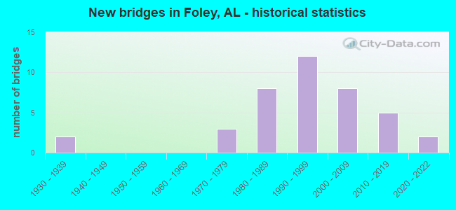
- New bridges - historical statistics
- 21930-1939
- 31970-1979
- 81980-1989
- 121990-1999
- 82000-2009
- 52010-2019
- 22020-2022
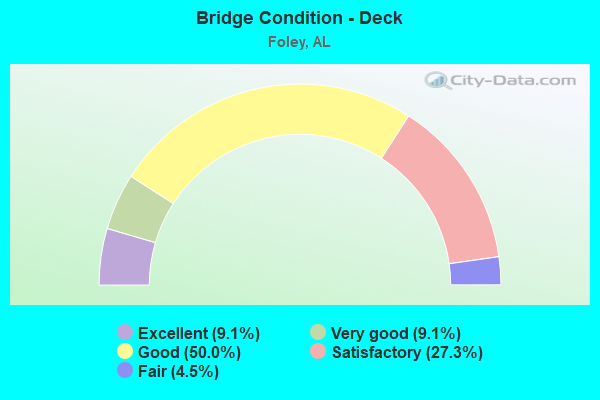
- Bridge Condition - Deck
- 9.1%Excellent
- 9.1%Very good
- 50.0%Good
- 27.3%Satisfactory
- 4.5%Fair
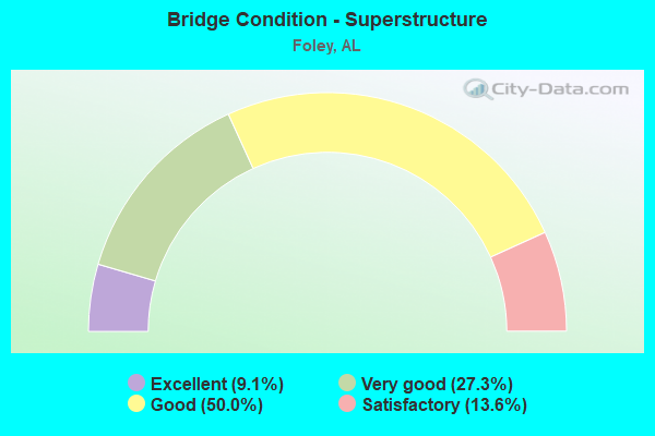
- Bridge Condition - Superstructure
- 9.1%Excellent
- 27.3%Very good
- 50.0%Good
- 13.6%Satisfactory
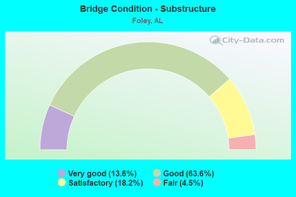
- Bridge Condition - Substructure
- 13.6%Very good
- 63.6%Good
- 18.2%Satisfactory
- 4.5%Fair
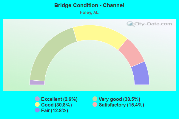
- Bridge Condition - Channel
- 2.6%Excellent
- 38.5%Very good
- 30.8%Good
- 15.4%Satisfactory
- 12.8%Fair
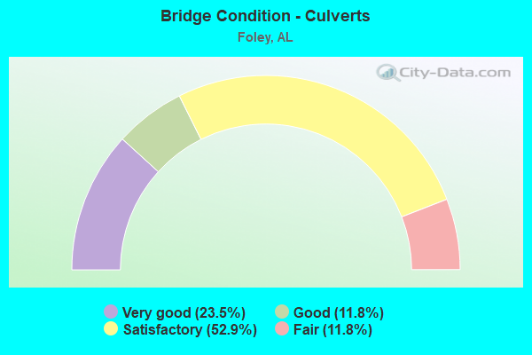
- Bridge Condition - Culverts
- 23.5%Very good
- 11.8%Good
- 52.9%Satisfactory
- 11.8%Fair
Find on map >> Show street view
Structure Number: 2021, Location: 1.5 MI SO JCT ST RT 160 (Lat: 33.990000, Lng: -86.566667), Route carried "on" structure: US 231, Year Built: 1939, Status: Open, Structure Length: 1.01m (3.31ft), Average Daily Traffic: 6,460 (year 2021), Truck Traffic: 3%, Average Future Daily Traffic: 8,397 (year 2041), Features Intersected: BRANCH
Minimum Vertical Clearance: 30+ m (98+ ft), Kilometerpoint: 418.616, Lanes on structure: 2, Owner: State Highway Agency, Approaching Roadway Width: 7.3m (24.0ft), Material/Design: Concrete, Design/Construction: Culvert, Number Of Spans In Main Unit: 3, Length of Maximum Span: 3.0m (9.8ft)
Condition: Channel: Satisfactory, Culverts: Satisfactory, Operating Rating: 88.9 metric tons, Method Used To Determine Operating Rating: Load Factor (LF), Inventory Rating: 71.7 metric tons, Method Used To Determine Inventory Rating: Load Factor (LF), Structural Evaluation: Equal to present minimum criteria, Waterway Adequacy: Equal to present minimum criteria, Approach Roadway Alignment: Equal to present desirable criteria, Length Of Structure Improvement: 1.68m (5.51ft), Designated Inspection Frequency: Every 24 months, Inspection Date: Febuary 2021, Bridge Improvement Cost: $466,000, Roadway Improvement Cost: $47,000, Total Project Cost: $513,000 ( Estimate for 2022), Wearing Surface/Protective System: Wearing Surface: Bituminous
Find on map >> Show street view
Structure Number: 11675, Location: 0.25 MI S C0 RD 10 (Lat: 30.329889, Lng: -87.683222), Route carried "on" structure: State highway 59, Year Built: 1976, Status: Open, Structure Length: 4.15m (13.62ft), Average Daily Traffic: 18,342 (year 2019), Truck Traffic: 6%, Average Future Daily Traffic: 27,513 (year 2039), Design Load: HS 20, Features Intersected: BOGGY BRANCH
Minimum Vertical Clearance: 30+ m (98+ ft), Kilometerpoint: 9.091, Lanes on structure: 2, Base Highway Network: Yes, Owner: State Highway Agency, Approaching Roadway Width: 12.2m (40.0ft), Skew: 10 degrees, Material/Design: Prestressed concrete, Design/Construction: Stringer/Multi-beam, Number Of Spans In Main Unit: 4, Length of Maximum Span: 10.4m (34.1ft), Curb-To-Curb Width: 11.9m (39.0ft), Out-to-Out Width: 13.1m (43.0ft)
Condition: Deck: Satisfactory, Superstructure: Satisfactory, Substructure: Satisfactory, Channel: Satisfactory, Operating Rating: 67.3 metric tons, Method Used To Determine Operating Rating: Load Factor (LF), Inventory Rating: 40.3 metric tons, Method Used To Determine Inventory Rating: Load Factor (LF), Structural Evaluation: Equal to present minimum criteria, Deck Geometry: Better than present minimum criteria, Waterway Adequacy: Equal to present minimum criteria, Approach Roadway Alignment: Equal to present desirable criteria, Length Of Structure Improvement: 5.11m (16.77ft), Designated Inspection Frequency: Every 24 months, Underwater Inspection Frequency: Every 24 months, Inspection Date: December 2020, Underwater Inspection Date: November 2021, Bridge Improvement Cost: $1,507,000, Roadway Improvement Cost: $151,000, Total Project Cost: $1,658,000 ( Estimate for 2022), Deck Structure Type: Concrete Cast-file-Place
Find on map >> Show street view
Structure Number: 11676, Location: 0.25 MI S CO RD 10 (Lat: 30.329917, Lng: -87.683000), Route carried "on" structure: State highway 59, Year Built: 1976, Status: Open, Structure Length: 4.15m (13.62ft), Average Daily Traffic: 18,342 (year 2019), Truck Traffic: 6%, Average Future Daily Traffic: 27,513 (year 2039), Design Load: HS 20, Features Intersected: BOGGY BRANCH
Minimum Vertical Clearance: 30+ m (98+ ft), Kilometerpoint: 9.091, Lanes on structure: 3, Base Highway Network: Yes, Owner: State Highway Agency, Approaching Roadway Width: 12.2m (40.0ft), Skew: 10 degrees, Material/Design: Prestressed concrete, Design/Construction: Stringer/Multi-beam, Number Of Spans In Main Unit: 4, Length of Maximum Span: 10.4m (34.1ft), Curb-To-Curb Width: 11.9m (39.0ft), Out-to-Out Width: 13.1m (43.0ft)
Condition: Deck: Satisfactory, Superstructure: Satisfactory, Substructure: Satisfactory, Channel: Fair, Operating Rating: 58.3 metric tons, Method Used To Determine Operating Rating: Load Factor (LF), Inventory Rating: 36.6 metric tons, Method Used To Determine Inventory Rating: Load Factor (LF), Structural Evaluation: Equal to present minimum criteria, Deck Geometry: High priority of corrective action, Waterway Adequacy: Equal to present minimum criteria, Approach Roadway Alignment: Equal to present desirable criteria, Length Of Structure Improvement: 5.11m (16.77ft), Designated Inspection Frequency: Every 24 months, Underwater Inspection Frequency: Every 24 months, Inspection Date: December 2020, Underwater Inspection Date: November 2020, Bridge Improvement Cost: $1,507,000, Roadway Improvement Cost: $151,000, Total Project Cost: $1,658,000 ( Estimate for 2022), Deck Structure Type: Concrete Cast-file-Place
Find on map >> Show street view
Structure Number: 11677, Location: 0.1 MI S CO RD 12 (Lat: 30.353639, Lng: -87.683167), Route carried "on" structure: State highway 59, Year Built: 1974, Status: Open, Structure Length: 1.55m (5.09ft), Average Daily Traffic: 42,233 (year 2019), Truck Traffic: 5%, Average Future Daily Traffic: 63,349 (year 2039), Design Load: HS 20, Features Intersected: KELLER CREEK
Minimum Vertical Clearance: 30+ m (98+ ft), Kilometerpoint: 11.716, Lanes on structure: 5, Base Highway Network: Yes, Owner: State Highway Agency, Approaching Roadway Width: 23.0m (75.5ft), Skew: 10 degrees, Material/Design: Concrete, Design/Construction: Culvert, Number Of Spans In Main Unit: 4, Length of Maximum Span: 3.7m (12.1ft)
Condition: Channel: Satisfactory, Culverts: Fair, Operating Rating: 77.3 metric tons, Method Used To Determine Operating Rating: Load Factor (LF), Inventory Rating: 46.4 metric tons, Method Used To Determine Inventory Rating: Load Factor (LF), Structural Evaluation: Somewhat better than minimum adequacy, Waterway Adequacy: Equal to present minimum criteria, Approach Roadway Alignment: Better than present minimum criteria, Length Of Structure Improvement: 2.24m (7.35ft), Designated Inspection Frequency: Every 24 months, Inspection Date: November 2020, Bridge Improvement Cost: $1,564,000, Roadway Improvement Cost: $156,000, Total Project Cost: $1,720,000 ( Estimate for 2022)
Find on map >> Show street view
Structure Number: 12865, Location: 2.7 MI N JCT US 98 (Lat: 30.445500, Lng: -87.683256), Route carried "on" structure: State highway 59, Year Built: 1936, Year Reconstructed: 1983, Status: Open, Structure Length: 1.01m (3.31ft), Average Daily Traffic: 27,857 (year 2019), Truck Traffic: 2%, Average Future Daily Traffic: 41,786 (year 2039), Design Load: H 15, Features Intersected: MAGNOLIA RIVER
Minimum Vertical Clearance: 30+ m (98+ ft), Kilometerpoint: 21.900, Lanes on structure: 5, Base Highway Network: Yes, Owner: State Highway Agency, Approaching Roadway Width: 21.1m (69.2ft), Material/Design: Concrete, Design/Construction: Culvert, Number Of Spans In Main Unit: 3, Length of Maximum Span: 3.0m (9.8ft)
Condition: Channel: Fair, Culverts: Fair, Operating Rating: 38.6 metric tons, Method Used To Determine Operating Rating: Load Factor (LF), Inventory Rating: 23.1 metric tons, Method Used To Determine Inventory Rating: Load Factor (LF), Structural Evaluation: Somewhat better than minimum adequacy, Waterway Adequacy: Equal to present minimum criteria, Approach Roadway Alignment: Equal to present desirable criteria, Length Of Structure Improvement: 1.68m (5.51ft), Designated Inspection Frequency: Every 24 months, Inspection Date: November 2020, Bridge Improvement Cost: $842,000, Roadway Improvement Cost: $84,000, Total Project Cost: $926,000 ( Estimate for 2022)
Find on map >> Show street view
Structure Number: 13595, Location: 1.4 MI. W. OF AL. HWY. 59 (Lat: 30.355669, Lng: -87.707558), Route carried "on" structure: County highway 12, Year Built: 1985, Status: Open, Structure Length: 3.11m (10.20ft), Average Daily Traffic: 1,753 (year 2018), Truck Traffic: 1%, Average Future Daily Traffic: 2,368 (year 2038), Design Load: HS 20, Features Intersected: BON SECOUR RIVER
Minimum Vertical Clearance: 30+ m (98+ ft), Kilometerpoint: 0.010, Lanes on structure: 2, Owner: County Highway Agency, Approaching Roadway Width: 10.4m (34.1ft), Material/Design: Concrete, Design/Construction: Channel Beam, Number Of Spans In Main Unit: 3, Length of Maximum Span: 10.4m (34.1ft), Curb-To-Curb Width: 10.5m (34.4ft), Out-to-Out Width: 11.3m (37.1ft)
Condition: Deck: Good, Superstructure: Good, Substructure: Satisfactory, Channel: Good, Operating Rating: 55.2 metric tons, Method Used To Determine Operating Rating: Load Factor (LF), Inventory Rating: 33.0 metric tons, Method Used To Determine Inventory Rating: Load Factor (LF), Structural Evaluation: Equal to present minimum criteria, Deck Geometry: Equal to present minimum criteria, Waterway Adequacy: Better than present minimum criteria, Approach Roadway Alignment: Equal to present minimum criteria, Length Of Structure Improvement: 3.96m (12.99ft), Designated Inspection Frequency: Every 24 months, Inspection Date: July 2020, Bridge Improvement Cost: $1,005,000, Roadway Improvement Cost: $101,000, Total Project Cost: $1,106,000 ( Estimate for 2022), Deck Structure Type: Concrete Precast Panels
Find on map >> Show street view
Structure Number: 13649, Location: 0.8 MI E SR 59 (Lat: 30.406833, Lng: -87.668694), Route carried "on" structure: US 98, Year Built: 1985, Status: Open, Structure Length: 0.70m (2.30ft), Average Daily Traffic: 9,563 (year 2020), Truck Traffic: 2%, Average Future Daily Traffic: 14,345 (year 2040), Design Load: HS 20, Features Intersected: WOLF CREEK
Minimum Vertical Clearance: 30+ m (98+ ft), Kilometerpoint: 105.536, Lanes on structure: 2, Owner: State Highway Agency, Approaching Roadway Width: 8.5m (27.9ft), Skew: 2 degrees, Material/Design: Concrete, Design/Construction: Culvert, Number Of Spans In Main Unit: 2, Length of Maximum Span: 3.0m (9.8ft)
Condition: Channel: Good, Culverts: Satisfactory, Operating Rating: 85.6 metric tons, Method Used To Determine Operating Rating: Load Factor (LF), Inventory Rating: 51.3 metric tons, Method Used To Determine Inventory Rating: Load Factor (LF), Structural Evaluation: Equal to present minimum criteria, Waterway Adequacy: Equal to present minimum criteria, Approach Roadway Alignment: Equal to present desirable criteria, Length Of Structure Improvement: 1.34m (4.40ft), Designated Inspection Frequency: Every 24 months, Underwater Inspection Frequency: Every 24 months, Inspection Date: November 2021, Underwater Inspection Date: November 2021, Bridge Improvement Cost: $379,000, Roadway Improvement Cost: $38,000, Total Project Cost: $417,000 ( Estimate for 2022)
Find on map >> Show street view
Structure Number: 1365, Location: 1.7 MI E SR 59 (Lat: 30.406836, Lng: -87.655867), Route carried "on" structure: US 98, Year Built: 1985, Status: Open, Structure Length: 0.64m (2.10ft), Average Daily Traffic: 11,559 (year 2019), Truck Traffic: 5%, Average Future Daily Traffic: 17,338 (year 2039), Design Load: HS 20, Features Intersected: WORM BRANCH
Minimum Vertical Clearance: 30+ m (98+ ft), Kilometerpoint: 106.762, Lanes on structure: 2, Owner: State Highway Agency, Approaching Roadway Width: 8.8m (28.9ft), Material/Design: Concrete, Design/Construction: Culvert, Number Of Spans In Main Unit: 2, Length of Maximum Span: 3.0m (9.8ft)
Condition: Channel: Good, Culverts: Satisfactory, Operating Rating: 88.9 metric tons, Method Used To Determine Operating Rating: Load Factor (LF), Inventory Rating: 57.6 metric tons, Method Used To Determine Inventory Rating: Load Factor (LF), Structural Evaluation: Equal to present minimum criteria, Waterway Adequacy: Equal to present minimum criteria, Approach Roadway Alignment: Equal to present desirable criteria, Length Of Structure Improvement: 1.26m (4.13ft), Designated Inspection Frequency: Every 24 months, Inspection Date: November 2020, Bridge Improvement Cost: $328,000, Roadway Improvement Cost: $33,000, Total Project Cost: $361,000 ( Estimate for 2022)
Find on map >> Show street view
Structure Number: 14233, Location: 0.6 MI E CO 49 (Lat: 30.406572, Lng: -87.756425), Route carried "on" structure: US 98, Year Built: 1987, Status: Open, Structure Length: 1.46m (4.79ft), Average Daily Traffic: 11,942 (year 2019), Truck Traffic: 5%, Average Future Daily Traffic: 17,913 (year 2039), Design Load: HS 20, Features Intersected: SCHOOL HOUSE CREEK
Minimum Vertical Clearance: 30+ m (98+ ft), Kilometerpoint: 97.063, Lanes on structure: 2, Owner: State Highway Agency, Approaching Roadway Width: 8.6m (28.2ft), Skew: 3 degrees, Material/Design: Concrete, Design/Construction: Culvert, Number Of Spans In Main Unit: 4, Length of Maximum Span: 3.0m (9.8ft)
Condition: Channel: Fair, Culverts: Satisfactory, Operating Rating: 80.6 metric tons, Method Used To Determine Operating Rating: Load Factor (LF), Inventory Rating: 48.4 metric tons, Method Used To Determine Inventory Rating: Load Factor (LF), Structural Evaluation: Equal to present minimum criteria, Waterway Adequacy: Equal to present minimum criteria, Approach Roadway Alignment: Equal to present desirable criteria, Length Of Structure Improvement: 2.14m (7.02ft), Designated Inspection Frequency: Every 24 months, Inspection Date: November 2020, Bridge Improvement Cost: $977,000, Roadway Improvement Cost: $98,000, Total Project Cost: $1,075,000 ( Estimate for 2022)
Find on map >> Show street view
Structure Number: 14234, Location: 3.2 MI E SR 59 (Lat: 30.406864, Lng: -87.630447), Route carried "on" structure: US 98, Year Built: 1987, Status: Open, Structure Length: 4.08m (13.39ft), Average Daily Traffic: 10,420 (year 2019), Truck Traffic: 6%, Average Future Daily Traffic: 15,630 (year 2039), Design Load: HS 20, Features Intersected: SANDY CREEK
Minimum Vertical Clearance: 30+ m (98+ ft), Kilometerpoint: 109.215, Lanes on structure: 2, Owner: State Highway Agency, Approaching Roadway Width: 8.5m (27.9ft), Material/Design: Prestressed concrete continuous, Design/Construction: Stringer/Multi-beam, Number Of Spans In Main Unit: 4, Length of Maximum Span: 10.4m (34.1ft), Curb-To-Curb Width: 12.2m (40.0ft), Out-to-Out Width: 13.1m (43.0ft)
Condition: Deck: Satisfactory, Superstructure: Good, Substructure: Good, Channel: Satisfactory, Operating Rating: 57.2 metric tons, Method Used To Determine Operating Rating: Load Factor (LF), Inventory Rating: 33.9 metric tons, Method Used To Determine Inventory Rating: Load Factor (LF), Structural Evaluation: Better than present minimum criteria, Deck Geometry: Somewhat better than minimum adequacy, Waterway Adequacy: Equal to present minimum criteria, Approach Roadway Alignment: Equal to present desirable criteria, Length Of Structure Improvement: 5.05m (16.57ft), Designated Inspection Frequency: Every 24 months, Inspection Date: December 2020, Bridge Improvement Cost: $1,488,000, Roadway Improvement Cost: $149,000, Total Project Cost: $1,637,000 ( Estimate for 2022), Deck Structure Type: Concrete Cast-file-Place
Find on map >> Show street view
Structure Number: 14259, Location: 2.6 MI. N. OF CO. RD. 32 (Lat: 30.510931, Lng: -87.581678), Route carried "on" structure: County highway 87, Year Built: 1987, Status: Open, Structure Length: 11.43m (37.50ft), Average Daily Traffic: 1,247 (year 2019), Truck Traffic: 1%, Average Future Daily Traffic: 1,684 (year 2039), Design Load: HS 20, Features Intersected: BLACKWATER RIVER
Minimum Vertical Clearance: 30+ m (98+ ft), Kilometerpoint: 0.010, Lanes on structure: 2, Owner: County Highway Agency, Approaching Roadway Width: 11.3m (37.1ft), Material/Design: Concrete, Design/Construction: Channel Beam, Number Of Spans In Main Unit: 11, Length of Maximum Span: 10.4m (34.1ft), Curb-To-Curb Width: 8.6m (28.2ft), Out-to-Out Width: 9.4m (30.8ft)
Condition: Deck: Satisfactory, Superstructure: Satisfactory, Substructure: Fair, Channel: Satisfactory, Operating Rating: 45.4 metric tons, Method Used To Determine Operating Rating: Allowable Stress (AS), Inventory Rating: 33.6 metric tons, Method Used To Determine Inventory Rating: Allowable Stress (AS), Structural Evaluation: Somewhat better than minimum adequacy, Deck Geometry: Somewhat better than minimum adequacy, Waterway Adequacy: Better than present minimum criteria, Approach Roadway Alignment: Equal to present desirable criteria, Length Of Structure Improvement: 12.30m (40.35ft), Designated Inspection Frequency: Every 24 months, Inspection Date: October 2021, Bridge Improvement Cost: $2,531,000, Roadway Improvement Cost: $253,000, Total Project Cost: $2,784,000 ( Estimate for 2022), Deck Structure Type: Concrete Precast Panels
Find on map >> Show street view
Structure Number: 14586, Location: 1.1 MI W CO 65 (Lat: 30.406608, Lng: -87.737486), Route carried "on" structure: US 98, Year Built: 1988, Status: Open, Structure Length: 10.00m (32.81ft), Average Daily Traffic: 11,942 (year 2019), Truck Traffic: 5%, Average Future Daily Traffic: 17,913 (year 2039), Design Load: HS 20, Features Intersected: MAGNOLIA RIVER
Minimum Vertical Clearance: 30+ m (98+ ft), Kilometerpoint: 98.941, Lanes on structure: 2, Owner: State Highway Agency, Approaching Roadway Width: 8.5m (27.9ft), Skew: 4 degrees, Material/Design: Prestressed concrete, Design/Construction: Stringer/Multi-beam, Number Of Spans In Main Unit: 8, Length of Maximum Span: 12.5m (41.0ft), Curb-To-Curb Width: 12.2m (40.0ft), Out-to-Out Width: 13.0m (42.7ft)
Condition: Deck: Good, Superstructure: Good, Substructure: Good, Channel: Satisfactory, Operating Rating: 41.5 metric tons, Method Used To Determine Operating Rating: Load Factor (LF), Inventory Rating: 23.0 metric tons, Method Used To Determine Inventory Rating: Load Factor (LF), Structural Evaluation: Somewhat better than minimum adequacy, Deck Geometry: Somewhat better than minimum adequacy, Waterway Adequacy: Equal to present minimum criteria, Approach Roadway Alignment: Equal to present desirable criteria, Length Of Structure Improvement: 10.93m (35.86ft), Designated Inspection Frequency: Every 24 months, Inspection Date: October 2020, Bridge Improvement Cost: $3,147,000, Roadway Improvement Cost: $315,000, Total Project Cost: $3,462,000 ( Estimate for 2022), Deck Structure Type: Concrete Cast-file-Place
Find on map >> Show street view
Structure Number: 15655, Location: 0.63 MI. W. SR 59 (Lat: 30.392103, Lng: -87.692092), Route carried "on" structure: City street , Year Built: 1992, Status: Open, Structure Length: 0.79m (2.59ft), Average Daily Traffic: 298 (year 2018), Truck Traffic: 1%, Average Future Daily Traffic: 402 (year 2038), Design Load: H 15, Features Intersected: RELIEF, Facility Carried by Structure: W. MICHIGAN AVENU
Minimum Vertical Clearance: 7.56m (24.80ft), Kilometerpoint: 9.502, Lanes on structure: 2, Owner: City or Municipal Highway Agency, Approaching Roadway Width: 12.5m (41.0ft), Material/Design: Steel, Design/Construction: Culvert, Number Of Spans In Main Unit: 4, Length of Maximum Span: 1.5m (4.9ft)
Condition: Channel: Very good, Culverts: Good, Operating Rating: 57.0 metric tons, Method Used To Determine Operating Rating: Load Factor (LF), Inventory Rating: 34.2 metric tons, Method Used To Determine Inventory Rating: Load Factor (LF), Structural Evaluation: Better than present minimum criteria, Waterway Adequacy: Better than present minimum criteria, Approach Roadway Alignment: Equal to present desirable criteria, Length Of Structure Improvement: 1.44m (4.72ft), Designated Inspection Frequency: Every 24 months, Inspection Date: September 2020, Bridge Improvement Cost: $333,000, Roadway Improvement Cost: $33,000, Total Project Cost: $366,000 ( Estimate for 2022)
Find on map >> Show street view
Structure Number: 15819, Location: 0.5 MI N US 98 (Lat: 30.413119, Lng: -87.683764), Route carried "on" structure: State highway 59, Year Built: 1993, Status: Open, Structure Length: 0.64m (2.10ft), Average Daily Traffic: 29,936 (year 2019), Truck Traffic: 6%, Average Future Daily Traffic: 44,904 (year 2039), Design Load: HS 20, Features Intersected: WOLF CREEK
Minimum Vertical Clearance: 30+ m (98+ ft), Kilometerpoint: 18.316, Lanes on structure: 5, Owner: State Highway Agency, Approaching Roadway Width: 18.0m (59.1ft), Material/Design: Concrete, Design/Construction: Culvert, Number Of Spans In Main Unit: 2, Length of Maximum Span: 3.0m (9.8ft)
Condition: Channel: Good, Culverts: Satisfactory, Operating Rating: 88.9 metric tons, Method Used To Determine Operating Rating: Load Factor (LF), Inventory Rating: 57.5 metric tons, Method Used To Determine Inventory Rating: Load Factor (LF), Structural Evaluation: Equal to present minimum criteria, Waterway Adequacy: Somewhat better than minimum adequacy, Approach Roadway Alignment: Equal to present desirable criteria, Length Of Structure Improvement: 1.26m (4.13ft), Designated Inspection Frequency: Every 24 months, Inspection Date: November 2020, Bridge Improvement Cost: $801,000, Roadway Improvement Cost: $80,000, Total Project Cost: $881,000 ( Estimate for 2022)
Find on map >> Show street view
Structure Number: 15824, Location: 0.2 MI N US 98 (Lat: 30.409389, Lng: -87.676272), Route carried "on" structure: City street , Year Built: 1987, Status: Open, Structure Length: 1.33m (4.36ft), Average Daily Traffic: 1,420 (year 2018), Truck Traffic: 5%, Average Future Daily Traffic: 1,917 (year 2038), Design Load: HS 20, Features Intersected: WOLF CREEK, Facility Carried by Structure: NORTH POPLAR ST.
Minimum Vertical Clearance: 30+ m (98+ ft), Kilometerpoint: 0.520, Lanes on structure: 2, Owner: City or Municipal Highway Agency, Approaching Roadway Width: 7.0m (23.0ft), Skew: 5 degrees, Material/Design: Concrete, Design/Construction: Culvert, Number Of Spans In Main Unit: 3, Length of Maximum Span: 3.2m (10.5ft)
Condition: Channel: Good, Culverts: Satisfactory, Operating Rating: 66.9 metric tons, Method Used To Determine Operating Rating: Load Factor (LF), Inventory Rating: 40.1 metric tons, Method Used To Determine Inventory Rating: Load Factor (LF), Structural Evaluation: Equal to present minimum criteria, Waterway Adequacy: Better than present minimum criteria, Approach Roadway Alignment: Equal to present desirable criteria, Length Of Structure Improvement: 2.00m (6.56ft), Designated Inspection Frequency: Every 24 months, Inspection Date: September 2020, Bridge Improvement Cost: $784,000, Roadway Improvement Cost: $78,000, Total Project Cost: $862,000 ( Estimate for 2022)
Find on map >> Show street view
Structure Number: 16028, Location: 0.3 MI. N. OF CO. RD. 20 (Lat: 30.373372, Lng: -87.632553), Route carried "on" structure: County highway , Year Built: 1995, Status: Open, Structure Length: 3.11m (10.20ft), Average Daily Traffic: 239 (year 2019), Truck Traffic: 1%, Average Future Daily Traffic: 323 (year 2039), Design Load: HS 20, Features Intersected: WOLF CREEK, Facility Carried by Structure: SWIFT CHURCH RD.
Minimum Vertical Clearance: 30+ m (98+ ft), Kilometerpoint: 0.010, Lanes on structure: 2, Owner: County Highway Agency, Approaching Roadway Width: 12.5m (41.0ft), Material/Design: Concrete, Design/Construction: Channel Beam, Number Of Spans In Main Unit: 3, Length of Maximum Span: 10.4m (34.1ft), Curb-To-Curb Width: 8.6m (28.2ft), Out-to-Out Width: 9.4m (30.8ft)
Condition: Deck: Good, Superstructure: Good, Substructure: Good, Channel: Good, Operating Rating: 54.9 metric tons, Method Used To Determine Operating Rating: Load Factor (LF), Inventory Rating: 32.8 metric tons, Method Used To Determine Inventory Rating: Load Factor (LF), Structural Evaluation: Better than present minimum criteria, Deck Geometry: Equal to present minimum criteria, Waterway Adequacy: Equal to present desirable criteria, Approach Roadway Alignment: Equal to present desirable criteria, Length Of Structure Improvement: 3.96m (12.99ft), Designated Inspection Frequency: Every 24 months, Underwater Inspection Frequency: Every 48 months, Inspection Date: October 2021, Underwater Inspection Date: December 2018, Bridge Improvement Cost: $815,000, Roadway Improvement Cost: $82,000, Total Project Cost: $897,000 ( Estimate for 2022), Deck Structure Type: Concrete Precast Panels
Find on map >> Show street view
Structure Number: 16192, Location: 0.9 MI. W. OF AL. HWY. 59 (Lat: 30.436028, Lng: -87.698725), Route carried "on" structure: County highway 24, Year Built: 1995, Status: Open, Structure Length: 2.07m (6.79ft), Average Daily Traffic: 1,716 (year 2019), Truck Traffic: 1%, Average Future Daily Traffic: 2,316 (year 2039), Design Load: HS 20, Features Intersected: MAGNOLIA RIVER
Minimum Vertical Clearance: 30+ m (98+ ft), Kilometerpoint: 0.010, Lanes on structure: 2, Owner: County Highway Agency, Approaching Roadway Width: 11.6m (38.1ft), Material/Design: Concrete, Design/Construction: Channel Beam, Number Of Spans In Main Unit: 2, Length of Maximum Span: 10.4m (34.1ft), Curb-To-Curb Width: 9.7m (31.8ft), Out-to-Out Width: 10.5m (34.4ft)
Condition: Deck: Good, Superstructure: Good, Substructure: Good, Channel: Good, Operating Rating: 54.9 metric tons, Method Used To Determine Operating Rating: Load Factor (LF), Inventory Rating: 32.8 metric tons, Method Used To Determine Inventory Rating: Load Factor (LF), Structural Evaluation: Better than present minimum criteria, Deck Geometry: Somewhat better than minimum adequacy, Waterway Adequacy: Better than present minimum criteria, Approach Roadway Alignment: Equal to present desirable criteria, Length Of Structure Improvement: 2.84m (9.32ft), Designated Inspection Frequency: Every 24 months, Inspection Date: October 2021, Bridge Improvement Cost: $661,000, Roadway Improvement Cost: $66,000, Total Project Cost: $727,000 ( Estimate for 2022), Deck Structure Type: Concrete Precast Panels
Find on map >> Show street view
Structure Number: 16193, Location: 0.5 MI. E. OF CO. RD. 55 (Lat: 30.435981, Lng: -87.732831), Route carried "on" structure: County highway 24, Year Built: 1995, Status: Open, Structure Length: 3.11m (10.20ft), Average Daily Traffic: 1,042 (year 2019), Truck Traffic: 1%, Average Future Daily Traffic: 1,407 (year 2039), Design Load: HS 20, Features Intersected: W PRONG OF MAGNOLIA RI.
Minimum Vertical Clearance: 30+ m (98+ ft), Kilometerpoint: 0.010, Lanes on structure: 2, Owner: County Highway Agency, Approaching Roadway Width: 13.1m (43.0ft), Material/Design: Concrete, Design/Construction: Channel Beam, Number Of Spans In Main Unit: 3, Length of Maximum Span: 10.4m (34.1ft), Curb-To-Curb Width: 9.7m (31.8ft), Out-to-Out Width: 10.5m (34.4ft)
Condition: Deck: Fair, Superstructure: Very good, Substructure: Satisfactory, Channel: Very good, Operating Rating: 54.9 metric tons, Method Used To Determine Operating Rating: Load Factor (LF), Inventory Rating: 32.8 metric tons, Method Used To Determine Inventory Rating: Load Factor (LF), Structural Evaluation: Equal to present minimum criteria, Deck Geometry: Somewhat better than minimum adequacy, Waterway Adequacy: Better than present minimum criteria, Approach Roadway Alignment: Equal to present desirable criteria, Length Of Structure Improvement: 3.96m (12.99ft), Designated Inspection Frequency: Every 24 months, Underwater Inspection Frequency: Every 48 months, Inspection Date: July 2021, Underwater Inspection Date: October 2021, Bridge Improvement Cost: $923,000, Roadway Improvement Cost: $92,000, Total Project Cost: $1,015,000 ( Estimate for 2022), Deck Structure Type: Concrete Precast Panels
Find on map >> Show street view
Structure Number: 16195, Location: 3.9 MI. E. OF AL. HWY. 59 (Lat: 30.370358, Lng: -87.618492), Route carried "on" structure: County highway 20, Year Built: 1996, Status: Open, Structure Length: 5.18m (16.99ft), Average Daily Traffic: 2,447 (year 2018), Truck Traffic: 5%, Average Future Daily Traffic: 3,303 (year 2038), Design Load: HS 20, Features Intersected: SANDY CREEK
Minimum Vertical Clearance: 7.56m (24.80ft), Kilometerpoint: 0.010, Lanes on structure: 2, Owner: County Highway Agency, Approaching Roadway Width: 12.2m (40.0ft), Material/Design: Concrete, Design/Construction: Channel Beam, Number Of Spans In Main Unit: 5, Length of Maximum Span: 10.4m (34.1ft), Curb-To-Curb Width: 9.7m (31.8ft), Out-to-Out Width: 10.5m (34.4ft)
Condition: Deck: Satisfactory, Superstructure: Good, Substructure: Good, Channel: Very good, Operating Rating: 54.9 metric tons, Method Used To Determine Operating Rating: Load Factor (LF), Inventory Rating: 32.8 metric tons, Method Used To Determine Inventory Rating: Load Factor (LF), Structural Evaluation: Better than present minimum criteria, Deck Geometry: Meets minimum limits, Waterway Adequacy: Equal to present desirable criteria, Approach Roadway Alignment: Equal to present desirable criteria, Length Of Structure Improvement: 6.20m (20.34ft), Designated Inspection Frequency: Every 24 months, Underwater Inspection Frequency: Every 48 months, Inspection Date: April 2020, Underwater Inspection Date: December 2018, Bridge Improvement Cost: $1,446,000, Roadway Improvement Cost: $145,000, Total Project Cost: $1,591,000 ( Estimate for 2022), Deck Structure Type: Concrete Precast Panels
Find on map >> Show street view
Structure Number: 16347, Location: 1.2 MI. N. OF U. S. 98 (Lat: 30.424781, Lng: -87.717144), Route carried "on" structure: County highway 65, Year Built: 1996, Status: Open, Structure Length: 3.11m (10.20ft), Average Daily Traffic: 3,322 (year 2018), Truck Traffic: 1%, Average Future Daily Traffic: 4,458 (year 2038), Design Load: H 15, Features Intersected: MAGNOLIA RIVER
Minimum Vertical Clearance: 30+ m (98+ ft), Kilometerpoint: 0.010, Lanes on structure: 2, Owner: County Highway Agency, Approaching Roadway Width: 12.2m (40.0ft), Material/Design: Concrete, Design/Construction: Channel Beam, Number Of Spans In Main Unit: 3, Length of Maximum Span: 10.4m (34.1ft), Curb-To-Curb Width: 9.4m (30.8ft), Out-to-Out Width: 10.2m (33.5ft)
Condition: Deck: Good, Superstructure: Good, Substructure: Good, Channel: Good, Operating Rating: 54.9 metric tons, Method Used To Determine Operating Rating: Load Factor (LF), Inventory Rating: 32.8 metric tons, Method Used To Determine Inventory Rating: Load Factor (LF), Structural Evaluation: Better than present minimum criteria, Deck Geometry: Meets minimum limits, Waterway Adequacy: Better than present minimum criteria, Approach Roadway Alignment: Equal to present desirable criteria, Length Of Structure Improvement: 3.96m (12.99ft), Designated Inspection Frequency: Every 24 months, Inspection Date: June 2020, Bridge Improvement Cost: $896,000, Roadway Improvement Cost: $90,000, Total Project Cost: $986,000 ( Estimate for 2022), Deck Structure Type: Concrete Precast Panels
Find on map >> Show street view
Structure Number: 1635, Location: 3.6 MI. E. OF AL. HWY. 59 (Lat: 30.370331, Lng: -87.623319), Route carried "on" structure: County highway 20, Year Built: 1996, Status: Open, Structure Length: 5.18m (16.99ft), Average Daily Traffic: 2,386 (year 2018), Truck Traffic: 5%, Average Future Daily Traffic: 3,221 (year 2038), Design Load: HS 20, Features Intersected: WOLF CREEK
Minimum Vertical Clearance: 30+ m (98+ ft), Kilometerpoint: 0.010, Lanes on structure: 2, Owner: County Highway Agency, Approaching Roadway Width: 12.2m (40.0ft), Material/Design: Concrete, Design/Construction: Channel Beam, Number Of Spans In Main Unit: 5, Length of Maximum Span: 10.4m (34.1ft), Curb-To-Curb Width: 9.3m (30.5ft), Out-to-Out Width: 10.1m (33.1ft)
Condition: Deck: Satisfactory, Superstructure: Good, Substructure: Good, Channel: Very good, Operating Rating: 54.9 metric tons, Method Used To Determine Operating Rating: Load Factor (LF), Inventory Rating: 32.8 metric tons, Method Used To Determine Inventory Rating: Load Factor (LF), Structural Evaluation: Better than present minimum criteria, Deck Geometry: Meets minimum limits, Waterway Adequacy: Equal to present desirable criteria, Approach Roadway Alignment: Equal to present desirable criteria, Length Of Structure Improvement: 6.20m (20.34ft), Designated Inspection Frequency: Every 24 months, Underwater Inspection Frequency: Every 48 months, Inspection Date: April 2020, Underwater Inspection Date: October 2021, Bridge Improvement Cost: $1,403,000, Roadway Improvement Cost: $140,000, Total Project Cost: $1,543,000 ( Estimate for 2022), Deck Structure Type: Concrete Precast Panels
Find on map >> Show street view
Structure Number: 16714, Location: 1.2 MI. W. OF CO. RD. 87 (Lat: 30.472869, Lng: -87.616594), Route carried "on" structure: County highway 32, Year Built: 1997, Status: Open, Structure Length: 2.08m (6.82ft), Average Daily Traffic: 1,128 (year 2018), Truck Traffic: 1%, Average Future Daily Traffic: 1,522 (year 2038), Design Load: HS 20, Features Intersected: MAURICE CREEK
Minimum Vertical Clearance: 30+ m (98+ ft), Kilometerpoint: 0.000, Lanes on structure: 2, Owner: County Highway Agency, Approaching Roadway Width: 14.6m (47.9ft), Material/Design: Concrete, Design/Construction: Channel Beam, Number Of Spans In Main Unit: 2, Length of Maximum Span: 10.4m (34.1ft), Curb-To-Curb Width: 9.4m (30.8ft), Out-to-Out Width: 10.1m (33.1ft)
Condition: Deck: Good, Superstructure: Good, Substructure: Good, Channel: Very good, Operating Rating: 54.9 metric tons, Method Used To Determine Operating Rating: Load Factor (LF), Inventory Rating: 32.8 metric tons, Method Used To Determine Inventory Rating: Load Factor (LF), Structural Evaluation: Better than present minimum criteria, Deck Geometry: Somewhat better than minimum adequacy, Waterway Adequacy: Better than present minimum criteria, Approach Roadway Alignment: Equal to present desirable criteria, Length Of Structure Improvement: 2.85m (9.35ft), Designated Inspection Frequency: Every 24 months, Inspection Date: May 2020, Bridge Improvement Cost: $644,000, Roadway Improvement Cost: $64,000, Total Project Cost: $708,000 ( Estimate for 2022), Deck Structure Type: Concrete Precast Panels
Find on map >> Show street view
Structure Number: 17278, Location: 0.5 MI. N. OF CO. RD. 24 (Lat: 30.442836, Lng: -87.691719), Route carried "on" structure: County highway , Year Built: 1998, Status: Open, Structure Length: 0.73m (2.40ft), Average Daily Traffic: 71 (year 2018), Average Future Daily Traffic: 96 (year 2038), Design Load: HS 20, Features Intersected: CREEK ( NO NAME ), Facility Carried by Structure: SHOOTS LANE
Minimum Vertical Clearance: 30+ m (98+ ft), Kilometerpoint: 0.010, Lanes on structure: 1, Owner: County Highway Agency, Approaching Roadway Width: 4.9m (16.1ft), Material/Design: Steel, Design/Construction: Culvert, Number Of Spans In Main Unit: 3, Length of Maximum Span: 1.8m (5.9ft)
Condition: Channel: Fair, Culverts: Satisfactory, Operating Rating: 88.9 metric tons, Method Used To Determine Operating Rating: Load Factor (LF), Inventory Rating: 88.9 metric tons, Method Used To Determine Inventory Rating: Load Factor (LF), Structural Evaluation: Equal to present minimum criteria, Waterway Adequacy: Equal to present minimum criteria, Approach Roadway Alignment: Equal to present minimum criteria, Length Of Structure Improvement: 1.38m (4.53ft), Designated Inspection Frequency: Every 24 months, Inspection Date: March 2020, Bridge Improvement Cost: $223,000, Roadway Improvement Cost: $22,000, Total Project Cost: $245,000 ( Estimate for 2022)
Find on map >> Show street view
Structure Number: 17668, Location: 3.4 MI. E. OF AL. HWY. 59 (Lat: 30.355772, Lng: -87.627353), Route carried "on" structure: County highway 12, Year Built: 1999, Status: Open, Structure Length: 0.70m (2.30ft), Average Daily Traffic: 54 (year 2019), Average Future Daily Traffic: 72 (year 2039), Design Load: H 15, Features Intersected: OWENS CREEK
Minimum Vertical Clearance: 30+ m (98+ ft), Kilometerpoint: 0.010, Lanes on structure: 2, Owner: City or Municipal Highway Agency, Approaching Roadway Width: 12.2m (40.0ft), Material/Design: Steel, Design/Construction: Culvert, Number Of Spans In Main Unit: 3, Length of Maximum Span: 2.2m (7.2ft)
Condition: Channel: Very good, Culverts: Satisfactory, Operating Rating: 32.7 metric tons, Method Used To Determine Operating Rating: Load Factor (LF), Inventory Rating: 32.7 metric tons, Method Used To Determine Inventory Rating: Load Factor (LF), Structural Evaluation: Equal to present minimum criteria, Waterway Adequacy: Better than present minimum criteria, Approach Roadway Alignment: Equal to present desirable criteria, Length Of Structure Improvement: 1.34m (4.40ft), Designated Inspection Frequency: Every 24 months, Inspection Date: September 2021, Bridge Improvement Cost: $464,000, Roadway Improvement Cost: $46,000, Total Project Cost: $510,000 ( Estimate for 2022)
Find on map >> Show street view
Structure Number: 1787, Location: 0.9 MI.W. OF STATE HWY 59 (Lat: 30.355642, Lng: -87.698889), Route carried "on" structure: County highway 12, Year Built: 2001, Status: Open, Structure Length: 1.04m (3.41ft), Average Daily Traffic: 1,820 (year 2019), Average Future Daily Traffic: 2,458 (year 2039), Design Load: HS 20, Features Intersected: BRANCH
Minimum Vertical Clearance: 30+ m (98+ ft), Kilometerpoint: 0.010, Lanes on structure: 2, Owner: County Highway Agency, Approaching Roadway Width: 13.4m (44.0ft), Material/Design: Concrete, Design/Construction: Channel Beam, Number Of Spans In Main Unit: 1, Length of Maximum Span: 10.4m (34.1ft), Curb-To-Curb Width: 12.3m (40.4ft), Out-to-Out Width: 13.1m (43.0ft)
Condition: Deck: Good, Superstructure: Good, Substructure: Very good, Channel: Very good, Operating Rating: 54.4 metric tons, Method Used To Determine Operating Rating: Load Factor (LF), Inventory Rating: 32.6 metric tons, Method Used To Determine Inventory Rating: Load Factor (LF), Structural Evaluation: Better than present minimum criteria, Deck Geometry: Better than present minimum criteria, Waterway Adequacy: Better than present minimum criteria, Approach Roadway Alignment: Equal to present desirable criteria, Length Of Structure Improvement: 1.71m (5.61ft), Designated Inspection Frequency: Every 24 months, Inspection Date: July 2021, Bridge Improvement Cost: $503,000, Roadway Improvement Cost: $50,000, Total Project Cost: $553,000 ( Estimate for 2022), Deck Structure Type: Concrete Cast-file-Place
Find on map >> Show street view
Structure Number: 19521, Location: 0.47 miles East of Hwy 59 (Lat: 30.341061, Lng: -87.675086), Route carried "on" structure: County highway 100, Year Built: 2017, Status: Open, Structure Length: 1.22m (4.00ft), Average Daily Traffic: 217 (year 2019), Truck Traffic: 1%, Average Future Daily Traffic: 286 (year 2039), Design Load: HS 20, Features Intersected: Boggy Branch, Facility Carried by Structure: Keller Road
Minimum Vertical Clearance: 30.18m (99.02ft), Kilometerpoint: 0.000, Lanes on structure: 2, Base Highway Network: Yes, Owner: City or Municipal Highway Agency, Approaching Roadway Width: 7.3m (24.0ft), Material/Design: Concrete, Design/Construction: Channel Beam, Number Of Spans In Main Unit: 1, Length of Maximum Span: 12.2m (40.0ft), Curb-To-Curb Width: 8.5m (27.9ft), Out-to-Out Width: 8.8m (28.9ft)
Condition: Deck: Very good, Superstructure: Very good, Substructure: Very good, Channel: Very good, Operating Rating: 88.9 metric tons, Method Used To Determine Operating Rating: Load Factor (LF), Inventory Rating: 54.4 metric tons, Method Used To Determine Inventory Rating: Load Factor (LF), Structural Evaluation: Equal to present desirable criteria, Deck Geometry: Equal to present minimum criteria, Waterway Adequacy: Equal to present desirable criteria, Approach Roadway Alignment: Equal to present desirable criteria, Length Of Structure Improvement: 1.89m (6.20ft), Designated Inspection Frequency: Every 24 months, Inspection Date: September 2021, Bridge Improvement Cost: $376,000, Roadway Improvement Cost: $38,000, Total Project Cost: $414,000 ( Estimate for 2022), Deck Structure Type: Concrete Precast Panels
Find on map >> Show street view
Structure Number: 19541, Location: 0.3 MI. E. OF AL. HWY. 59 (Lat: 30.355683, Lng: -87.677497), Route carried "on" structure: County highway 12, Year Built: 2005, Status: Open, Structure Length: 1.13m (3.71ft), Average Daily Traffic: 1,906 (year 2019), Truck Traffic: 1%, Average Future Daily Traffic: 2,512 (year 2039), Design Load: HS 20, Features Intersected: BRANCH OF BON SECOUR RI.
Minimum Vertical Clearance: 30+ m (98+ ft), Kilometerpoint: 0.000, Lanes on structure: 2, Owner: City or Municipal Highway Agency, Approaching Roadway Width: 7.9m (25.9ft), Material/Design: Concrete continuous, Design/Construction: Culvert, Number Of Spans In Main Unit: 3, Length of Maximum Span: 3.7m (12.1ft), Curb-To-Curb Width: 11.3m (37.1ft), Out-to-Out Width: 11.3m (37.1ft)
Condition: Channel: Very good, Culverts: Satisfactory, Operating Rating: 56.6 metric tons, Method Used To Determine Operating Rating: Load Factor (LF), Inventory Rating: 34.0 metric tons, Method Used To Determine Inventory Rating: Load Factor (LF), Structural Evaluation: Equal to present minimum criteria, Deck Geometry: Equal to present minimum criteria, Waterway Adequacy: Better than present minimum criteria, Approach Roadway Alignment: Better than present minimum criteria, Length Of Structure Improvement: 1.81m (5.94ft), Designated Inspection Frequency: Every 24 months, Inspection Date: September 2021, Bridge Improvement Cost: $438,000, Roadway Improvement Cost: $44,000, Total Project Cost: $482,000 ( Estimate for 2022)
Find on map >> Show street view
Structure Number: 19971, Location: 1.2 MI. N. OF US 98 (Lat: 30.425500, Lng: -87.648500), Route carried "on" structure: City street , Year Built: 2000, Status: Open, Structure Length: 3.11m (10.20ft), Average Daily Traffic: 4,308 (year 2019), Truck Traffic: 5%, Average Future Daily Traffic: 5,674 (year 2039), Design Load: HS 20, Features Intersected: SANDY CREEK, Facility Carried by Structure: BEACH EXPRESS SO.
Minimum Vertical Clearance: 30+ m (98+ ft), Kilometerpoint: 0.000, Lanes on structure: 2, Owner: City or Municipal Highway Agency, Approaching Roadway Width: 7.0m (23.0ft), Material/Design: Prestressed concrete continuous, Design/Construction: Stringer/Multi-beam, Number Of Spans In Main Unit: 3, Length of Maximum Span: 10.4m (34.1ft), Curb-To-Curb Width: 12.2m (40.0ft), Out-to-Out Width: 13.0m (42.7ft)
Condition: Deck: Good, Superstructure: Very good, Substructure: Good, Channel: Very good, Operating Rating: 55.2 metric tons, Method Used To Determine Operating Rating: Load Factor (LF), Inventory Rating: 33.0 metric tons, Method Used To Determine Inventory Rating: Load Factor (LF), Structural Evaluation: Better than present minimum criteria, Deck Geometry: Better than present minimum criteria, Waterway Adequacy: Better than present minimum criteria, Approach Roadway Alignment: Equal to present desirable criteria, Length Of Structure Improvement: 3.96m (12.99ft), Designated Inspection Frequency: Every 24 months, Inspection Date: April 2021, Bridge Improvement Cost: $1,141,000, Roadway Improvement Cost: $114,000, Total Project Cost: $1,255,000 ( Estimate for 2022), Deck Structure Type: Concrete Cast-file-Place
Find on map >> Show street view
Structure Number: 19972, Location: 1.2 MI. N. OF US 98 (Lat: 30.425500, Lng: -87.648300), Route carried "on" structure: City street , Year Built: 2000, Status: Open, Structure Length: 3.11m (10.20ft), Average Daily Traffic: 4,308 (year 2019), Truck Traffic: 5%, Average Future Daily Traffic: 5,674 (year 2039), Design Load: HS 20, Features Intersected: SANDY CREEK, Facility Carried by Structure: BEACH EXPRESS NO.
Minimum Vertical Clearance: 30+ m (98+ ft), Kilometerpoint: 0.000, Lanes on structure: 2, Owner: City or Municipal Highway Agency, Approaching Roadway Width: 7.0m (23.0ft), Material/Design: Prestressed concrete continuous, Design/Construction: Stringer/Multi-beam, Number Of Spans In Main Unit: 3, Length of Maximum Span: 10.4m (34.1ft), Curb-To-Curb Width: 12.2m (40.0ft), Out-to-Out Width: 13.0m (42.7ft)
Condition: Deck: Good, Superstructure: Very good, Substructure: Good, Channel: Good, Operating Rating: 55.2 metric tons, Method Used To Determine Operating Rating: Load Factor (LF), Inventory Rating: 33.0 metric tons, Method Used To Determine Inventory Rating: Load Factor (LF), Structural Evaluation: Better than present minimum criteria, Deck Geometry: Better than present minimum criteria, Waterway Adequacy: Better than present minimum criteria, Approach Roadway Alignment: Equal to present desirable criteria, Length Of Structure Improvement: 3.96m (12.99ft), Designated Inspection Frequency: Every 24 months, Inspection Date: April 2021, Bridge Improvement Cost: $1,141,000, Roadway Improvement Cost: $114,000, Total Project Cost: $1,255,000 ( Estimate for 2022), Deck Structure Type: Concrete Cast-file-Place
Find on map >> Show street view
Structure Number: 19973, Location: 1.8 M. SO. OF U.S. 98 (Lat: 30.381389, Lng: -87.651667), Route carried "on" structure: City street , Year Built: 2000, Status: Open, Structure Length: 3.75m (12.30ft), Average Daily Traffic: 4,308 (year 2019), Truck Traffic: 5%, Average Future Daily Traffic: 5,674 (year 2039), Design Load: HS 20, Features Intersected: WOLF CREEK, Facility Carried by Structure: BEACH EXPRESS SO.
Minimum Vertical Clearance: 30+ m (98+ ft), Kilometerpoint: 0.000, Lanes on structure: 2, Owner: City or Municipal Highway Agency, Approaching Roadway Width: 7.0m (23.0ft), Material/Design: Prestressed concrete continuous, Design/Construction: Stringer/Multi-beam, Number Of Spans In Main Unit: 3, Length of Maximum Span: 12.5m (41.0ft), Curb-To-Curb Width: 12.2m (40.0ft), Out-to-Out Width: 13.0m (42.7ft)
Condition: Deck: Good, Superstructure: Very good, Substructure: Good, Channel: Fair, Operating Rating: 45.4 metric tons, Method Used To Determine Operating Rating: Load Factor (LF), Inventory Rating: 27.1 metric tons, Method Used To Determine Inventory Rating: Load Factor (LF), Structural Evaluation: Equal to present minimum criteria, Deck Geometry: Better than present minimum criteria, Waterway Adequacy: Better than present minimum criteria, Approach Roadway Alignment: Equal to present desirable criteria, Length Of Structure Improvement: 4.68m (15.35ft), Designated Inspection Frequency: Every 24 months, Underwater Inspection Frequency: Every 48 months, Inspection Date: April 2021, Underwater Inspection Date: April 2021, Bridge Improvement Cost: $1,347,000, Roadway Improvement Cost: $135,000, Total Project Cost: $1,482,000 ( Estimate for 2022), Deck Structure Type: Concrete Cast-file-Place
Find on map >> Show street view
Structure Number: 19974, Location: 1.8 M. SO. OF U.S. 98 (Lat: 30.381111, Lng: -87.651667), Route carried "on" structure: City street , Year Built: 2000, Status: Open, Structure Length: 3.75m (12.30ft), Average Daily Traffic: 4,308 (year 2019), Truck Traffic: 1%, Average Future Daily Traffic: 5,674 (year 2039), Design Load: HS 20, Features Intersected: WOLF CREEK, Facility Carried by Structure: BEACH EXPRESS NO.
Minimum Vertical Clearance: 30+ m (98+ ft), Kilometerpoint: 0.000, Lanes on structure: 2, Owner: City or Municipal Highway Agency, Approaching Roadway Width: 7.0m (23.0ft), Material/Design: Prestressed concrete, Design/Construction: Stringer/Multi-beam, Number Of Spans In Main Unit: 3, Length of Maximum Span: 12.5m (41.0ft), Curb-To-Curb Width: 12.2m (40.0ft), Out-to-Out Width: 13.0m (42.7ft)
Condition: Deck: Good, Superstructure: Very good, Substructure: Very good, Channel: Good, Operating Rating: 45.4 metric tons, Method Used To Determine Operating Rating: Load Factor (LF), Inventory Rating: 27.1 metric tons, Method Used To Determine Inventory Rating: Load Factor (LF), Structural Evaluation: Equal to present minimum criteria, Deck Geometry: Better than present minimum criteria, Waterway Adequacy: Better than present minimum criteria, Approach Roadway Alignment: Equal to present desirable criteria, Length Of Structure Improvement: 4.68m (15.35ft), Designated Inspection Frequency: Every 24 months, Underwater Inspection Frequency: Every 48 months, Inspection Date: April 2021, Underwater Inspection Date: April 2021, Bridge Improvement Cost: $1,347,000, Roadway Improvement Cost: $135,000, Total Project Cost: $1,482,000 ( Estimate for 2022), Deck Structure Type: Concrete Cast-file-Place
Find on map >> Show street view
Structure Number: 20199, Location: 155' S. OF W. SECTION AV (Lat: 30.400000, Lng: -87.683333), Route carried "on" structure: City street , Year Built: 2006, Status: Open, Structure Length: 0.83m (2.72ft), Average Daily Traffic: 210 (year 2018), Truck Traffic: 1%, Average Future Daily Traffic: 284 (year 2038), Design Load: HS 20, Features Intersected: BRANCH OF WOLF CREEK, Facility Carried by Structure: N. ALSTON STREET
Minimum Vertical Clearance: 30+ m (98+ ft), Kilometerpoint: 0.000, Lanes on structure: 2, Owner: City or Municipal Highway Agency, Approaching Roadway Width: 18.0m (59.1ft), Material/Design: Concrete, Design/Construction: Culvert, Number Of Spans In Main Unit: 3, Length of Maximum Span: 2.4m (7.9ft)
Condition: Channel: Good, Culverts: Very good, Operating Rating: 42.8 metric tons, Method Used To Determine Operating Rating: Load Factor (LF), Inventory Rating: 25.7 metric tons, Method Used To Determine Inventory Rating: Load Factor (LF), Structural Evaluation: Equal to present minimum criteria, Waterway Adequacy: Better than present minimum criteria, Approach Roadway Alignment: Equal to present desirable criteria, Length Of Structure Improvement: 1.49m (4.89ft), Designated Inspection Frequency: Every 24 months, Inspection Date: September 2020, Bridge Improvement Cost: $526,000, Roadway Improvement Cost: $53,000, Total Project Cost: $579,000 ( Estimate for 2022)
Find on map >> Show street view
Structure Number: 2021, Location: 0.3 MI. S. OF CR 24 (Lat: 30.431300, Lng: -87.704200), Route carried "on" structure: City street , Year Built: 2010, Status: Open, Structure Length: 3.11m (10.20ft), Average Daily Traffic: 106 (year 2019), Truck Traffic: 1%, Average Future Daily Traffic: 139 (year 2039), Design Load: HS 20, Features Intersected: MAGNOLIA RIVER, Facility Carried by Structure: AIRPORT ROAD
Minimum Vertical Clearance: 30+ m (98+ ft), Kilometerpoint: 0.161, Lanes on structure: 2, Owner: City or Municipal Highway Agency, Approaching Roadway Width: 7.6m (24.9ft), Material/Design: Concrete, Design/Construction: Channel Beam, Number Of Spans In Main Unit: 3, Length of Maximum Span: 10.4m (34.1ft), Curb-To-Curb Width: 8.6m (28.2ft), Out-to-Out Width: 9.4m (30.8ft)
Condition: Deck: Very good, Superstructure: Good, Substructure: Good, Channel: Very good, Operating Rating: 73.8 metric tons, Method Used To Determine Operating Rating: Load Factor (LF), Inventory Rating: 44.3 metric tons, Method Used To Determine Inventory Rating: Load Factor (LF), Structural Evaluation: Better than present minimum criteria, Deck Geometry: Equal to present minimum criteria, Waterway Adequacy: Better than present minimum criteria, Approach Roadway Alignment: Equal to present desirable criteria, Length Of Structure Improvement: 3.96m (12.99ft), Designated Inspection Frequency: Every 24 months, Inspection Date: April 2021, Bridge Improvement Cost: $815,000, Roadway Improvement Cost: $82,000, Total Project Cost: $897,000 ( Estimate for 2022), Deck Structure Type: Concrete Precast Panels
Find on map >> Show street view
Structure Number: 20267, Location: 0.1 MI.SO. OF CO. RD.24 (Lat: 30.435556, Lng: -87.691667), Route carried "on" structure: City street , Year Built: 1990, Status: Open, Structure Length: 0.71m (2.33ft), Average Daily Traffic: 209 (year 2019), Truck Traffic: 1%, Average Future Daily Traffic: 275 (year 2039), Design Load: H 20, Features Intersected: DRAINAGE, Facility Carried by Structure: NORTH CEDAR STREET
Minimum Vertical Clearance: 30+ m (98+ ft), Kilometerpoint: 0.000, Lanes on structure: 2, Owner: City or Municipal Highway Agency, Approaching Roadway Width: 9.8m (32.2ft), Material/Design: Steel, Design/Construction: Culvert, Number Of Spans In Main Unit: 4, Length of Maximum Span: 1.5m (4.9ft)
Condition: Channel: Very good, Culverts: Good, Operating Rating: 47.0 metric tons, Method Used To Determine Operating Rating: Load Factor (LF), Inventory Rating: 47.0 metric tons, Method Used To Determine Inventory Rating: Load Factor (LF), Structural Evaluation: Better than present minimum criteria, Waterway Adequacy: Better than present minimum criteria, Approach Roadway Alignment: Equal to present desirable criteria, Length Of Structure Improvement: 1.35m (4.43ft), Designated Inspection Frequency: Every 24 months, Inspection Date: April 2021, Bridge Improvement Cost: $390,000, Roadway Improvement Cost: $39,000, Total Project Cost: $429,000 ( Estimate for 2022)
Find on map >> Show street view
Structure Number: 20268, Location: 0.5 MI. EAST OF HWY.59 (Lat: 30.370289, Lng: -87.674814), Route carried "on" structure: City street , Year Built: 2007, Status: Open, Structure Length: 0.84m (2.76ft), Average Daily Traffic: 2,414 (year 2019), Truck Traffic: 5%, Average Future Daily Traffic: 3,181 (year 2039), Design Load: HS 20, Features Intersected: DRAINAGE, Facility Carried by Structure: MIFLIN ROAD
Minimum Vertical Clearance: 30+ m (98+ ft), Kilometerpoint: 0.000, Lanes on structure: 2, Owner: City or Municipal Highway Agency, Approaching Roadway Width: 19.8m (65.0ft), Material/Design: Concrete, Design/Construction: Culvert, Number Of Spans In Main Unit: 3, Length of Maximum Span: 3.6m (11.8ft)
Condition: Channel: Very good, Culverts: Very good, Operating Rating: 43.5 metric tons, Method Used To Determine Operating Rating: Field evaluation and documented engineering judgment, Inventory Rating: 32.7 metric tons, Method Used To Determine Inventory Rating: Field evaluation and documented engineering judgment, Structural Evaluation: Equal to present desirable criteria, Waterway Adequacy: Better than present minimum criteria, Approach Roadway Alignment: Equal to present desirable criteria, Length Of Structure Improvement: 1.50m (4.92ft), Designated Inspection Frequency: Every 24 months, Inspection Date: April 2021, Bridge Improvement Cost: $868,000, Roadway Improvement Cost: $87,000, Total Project Cost: $955,000 ( Estimate for 2022)
Find on map >> Show street view
Structure Number: 21107, Location: 1.17 M. W. of Hwy. 59_ (Lat: 30.392039, Lng: -87.702994), Route carried "on" structure: County highway 26, Year Built: 2016, Status: Open, Structure Length: 0.78m (2.56ft), Average Daily Traffic: 1,025 (year 2021), Truck Traffic: 1%, Average Future Daily Traffic: 1,383 (year 2041), Design Load: HS 20, Features Intersected: Trib. to Bon Secour Ri._
Minimum Vertical Clearance: 30+ m (98+ ft), Kilometerpoint: 0.010, Lanes on structure: 2, Owner: County Highway Agency, Approaching Roadway Width: 6.4m (21.0ft), Material/Design: Concrete, Design/Construction: Culvert, Number Of Spans In Main Unit: 3, Length of Maximum Span: 2.4m (7.9ft)
Condition: Channel: Very good, Culverts: Very good, Operating Rating: 86.6 metric tons, Method Used To Determine Operating Rating: Load Factor (LF), Inventory Rating: 51.9 metric tons, Method Used To Determine Inventory Rating: Load Factor (LF), Structural Evaluation: Equal to present desirable criteria, Waterway Adequacy: Equal to present desirable criteria, Approach Roadway Alignment: Equal to present desirable criteria, Length Of Structure Improvement: 1.43m (4.69ft), Designated Inspection Frequency: Every 24 months, Inspection Date: April 2021, Bridge Improvement Cost: $264,000, Roadway Improvement Cost: $26,000, Total Project Cost: $290,000 ( Estimate for 2022)
Find on map >> Show street view
Structure Number: 21212, Location: _500' S. of US 98 (Lat: 30.405178, Lng: -87.666369), Route carried "on" structure: City street , Year Built: 2015, Status: Open, Structure Length: 1.10m (3.61ft), Average Daily Traffic: 51 (year 2019), Average Future Daily Traffic: 68 (year 2039), Design Load: HS 20, Features Intersected: _Trib. to Wolf Creek, Facility Carried by Structure: _S. Pecan St.
Minimum Vertical Clearance: 30+ m (98+ ft), Kilometerpoint: 0.010, Lanes on structure: 2, Owner: City or Municipal Highway Agency, Approaching Roadway Width: 7.3m (24.0ft), Material/Design: Concrete, Design/Construction: Culvert, Number Of Spans In Main Unit: 3, Length of Maximum Span: 3.0m (9.8ft)
Condition: Channel: Excellent, Culverts: Very good, Operating Rating: 42.7 metric tons, Method Used To Determine Operating Rating: Load Factor (LF), Inventory Rating: 25.6 metric tons, Method Used To Determine Inventory Rating: Load Factor (LF), Structural Evaluation: Equal to present minimum criteria, Waterway Adequacy: Equal to present desirable criteria, Approach Roadway Alignment: Equal to present desirable criteria, Length Of Structure Improvement: 1.77m (5.81ft), Designated Inspection Frequency: Every 24 months, Inspection Date: September 2021, Bridge Improvement Cost: $450,000, Roadway Improvement Cost: $45,000, Total Project Cost: $495,000 ( Estimate for 2022)
Find on map >> Show street view
Structure Number: 21563, Location: 0.2 MI. N. of Co. Rd. 12 (Lat: 30.358181, Lng: -87.717142), Route carried "on" structure: County highway 65, Year Built: 2021, Status: Open, Structure Length: 2.03m (6.66ft), Average Daily Traffic: 1,726 (year 2021), Truck Traffic: 6%, Average Future Daily Traffic: 2,273 (year 2041), Design Load: HL 93, Features Intersected: Turkey Branch
Minimum Vertical Clearance: 30+ m (98+ ft), Kilometerpoint: 0.010, Lanes on structure: 2, Owner: County Highway Agency, Approaching Roadway Width: 10.7m (35.1ft), Material/Design: Concrete, Design/Construction: Tee Beam, Number Of Spans In Main Unit: 2, Number Of Approach Spans: 2, Length of Maximum Span: 10.1m (33.1ft), Curb-To-Curb Width: 7.3m (24.0ft), Out-to-Out Width: 10.5m (34.4ft)
Condition: Deck: Excellent, Superstructure: Excellent, Substructure: Good, Channel: Very good, Operating Rating: 64.0 metric tons, Method Used To Determine Operating Rating: Load and Resistance Factor (LRFR), Inventory Rating: 49.4 metric tons, Method Used To Determine Inventory Rating: Load and Resistance Factor (LRFR), Structural Evaluation: Better than present minimum criteria, Deck Geometry: Meets minimum limits, Waterway Adequacy: Equal to present desirable criteria, Approach Roadway Alignment: Equal to present minimum criteria, Length Of Structure Improvement: 2.79m (9.15ft), Designated Inspection Frequency: Every 24 months, Inspection Date: August 2021, Bridge Improvement Cost: $650,000, Roadway Improvement Cost: $65,000, Total Project Cost: $715,000 ( Estimate for 2022), Deck Structure Type: Concrete Precast Panels
Find on map >> Show street view
Structure Number: 21564, Location: 0.8 Mi. SE of C.R. 26 (Lat: 30.388450, Lng: -87.653203), Route carried "on" structure: County highway , Year Built: 2021, Status: Open, Structure Length: 3.06m (10.04ft), Average Daily Traffic: 115 (year 2018), Truck Traffic: 1%, Average Future Daily Traffic: 158 (year 2038), Design Load: HL 93, Features Intersected: Wolf Creek, Facility Carried by Structure: Doc McDuffie Rd
Minimum Vertical Clearance: 30+ m (98+ ft), Kilometerpoint: 0.010, Lanes on structure: 2, Owner: County Highway Agency, Approaching Roadway Width: 10.8m (35.4ft), Material/Design: Concrete, Design/Construction: Tee Beam, Number Of Spans In Main Unit: 3, Number Of Approach Spans: 2, Length of Maximum Span: 10.3m (33.8ft), Curb-To-Curb Width: 7.2m (23.6ft), Out-to-Out Width: 10.5m (34.4ft)
Condition: Deck: Excellent, Superstructure: Excellent, Substructure: Good, Channel: Good, Operating Rating: 49.5 metric tons, Method Used To Determine Operating Rating: Load and Resistance Factor (LRFR), Inventory Rating: 38.2 metric tons, Method Used To Determine Inventory Rating: Load and Resistance Factor (LRFR), Structural Evaluation: Better than present minimum criteria, Deck Geometry: Meets minimum limits, Waterway Adequacy: Better than present minimum criteria, Approach Roadway Alignment: Equal to present minimum criteria, Length Of Structure Improvement: 3.91m (12.83ft), Designated Inspection Frequency: Every 24 months, Inspection Date: September 2021, Bridge Improvement Cost: $911,000, Roadway Improvement Cost: $91,000, Total Project Cost: $1,002,000 ( Estimate for 2022), Deck Structure Type: Concrete Precast Panels
Find on map >> Show street view
Structure Number: 21287, Location: 450' North of US 98 (Lat: 30.407617, Lng: -87.683783), Route carried "under" structure: State highway 59, Year Built: 2016, Structure Length: 0. m, Average Daily Traffic: 29,360 (year 2015), Truck Traffic: 7%, Features Intersected: SR 59, Facility Carried by Structure: Pedestrian Bridge
Minimum Vertical Clearance: 6.14m (20.14ft), Kilometerpoint: 17.708, Lanes under structure: 5, Length of Maximum Span: 33.5m (109.9ft)