Bridge Statistics for Folsom, New Jersey (NJ)
Condition, Traffic, Stress, Structural Evaluation, Project Costs
- National Bridge Inventory (NBI) Statistics
- 13Number of bridges
- 115ft / 35.1mTotal length
- $31,759,000Total costs
- 102,377Total average daily traffic
- 3,964Total average daily truck traffic
- National Bridge Inventory (NBI) Registered Bridges for Folsom
- No street view available for this location
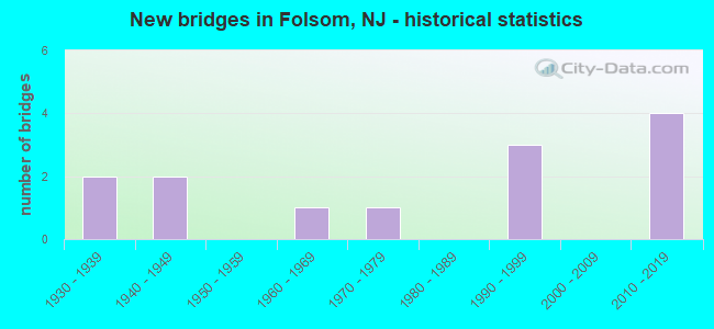
- New bridges - historical statistics
- 21930-1939
- 21940-1949
- 11960-1969
- 11970-1979
- 31990-1999
- 42010-2019


- Bridge Condition - Deck
- 8.3%Very good
- 50.0%Good
- 25.0%Satisfactory
- 8.3%Fair
- 8.3%Poor

- Bridge Condition - Superstructure
- 41.7%Very good
- 33.3%Good
- 16.7%Satisfactory
- 8.3%Poor

- Bridge Condition - Substructure
- 25.0%Very good
- 41.7%Good
- 16.7%Satisfactory
- 16.7%Fair

- Bridge Condition - Channel
- 30.0%Very good
- 20.0%Good
- 40.0%Satisfactory
- 10.0%Fair
Find on map >> Show street view
Structure Number: 114154, Location: 0.33 MI S OF 54-322 JCT. (Lat: 39.588119, Lng: -74.858581), Route carried "on" structure: State highway 54, Year Built: 2015, Status: Open, Structure Length: 13.38m (43.90ft), Average Daily Traffic: 11,775 (year 2021), Truck Traffic: 4%, Average Future Daily Traffic: 14,130 (year 2041), Design Load: HL 93, Features Intersected: CONRAIL/HOSPITALITYBROOK
Minimum Vertical Clearance: 30+ m (98+ ft), Kilometerpoint: 10.203, Lanes on structure: 2, Owner: State Highway Agency, Approaching Roadway Width: 13.4m (44.0ft), Material/Design: Steel continuous, Design/Construction: Stringer/Multi-beam, Number Of Spans In Main Unit: 3, Length of Maximum Span: 54.3m (178.1ft), Curb-To-Curb Width: 13.4m (44.0ft), Out-to-Out Width: 14.3m (46.9ft)
Condition: Deck: Good, Superstructure: Very good, Substructure: Very good, Channel: Very good, Operating Rating: 43.7 metric tons, Method Used To Determine Operating Rating: Load and Resistance Factor Rating (LRFR) rating reported by rating factor(RF) method using HL-93 loadings, Inventory Rating: 33.7 metric tons, Method Used To Determine Inventory Rating: Load and Resistance Factor Rating (LRFR) rating reported by rating factor(RF) method using HL-93 loadings, Structural Evaluation: Equal to present desirable criteria, Deck Geometry: Equal to present minimum criteria, Underclear: Equal to present desirable criteria, Waterway Adequacy: Superior to present desirable criteria, Approach Roadway Alignment: Equal to present minimum criteria, Designated Inspection Frequency: Every 24 months, Inspection Date: March 2021, Bridge Improvement Cost: $10,670,000, Roadway Improvement Cost: $1,067,000, Total Project Cost: $16,565,000, Deck Structure Type: Concrete Cast-file-Place, Wearing Surface/Protective System: Wearing Surface: Monolithic Concrete, Deck Protection: Epoxy Coated Reinforcing
Find on map >> Show street view
Structure Number: 114155, Location: 0.91 MILES S OF NJ 73 (Lat: 39.592311, Lng: -74.854431), Route carried "on" structure: State highway 54, Year Built: 2015, Status: Open, Structure Length: 3.17m (10.40ft), Average Daily Traffic: 11,775 (year 2021), Truck Traffic: 4%, Average Future Daily Traffic: 14,130 (year 2041), Design Load: HL 93, Features Intersected: US 322
Minimum Vertical Clearance: 30+ m (98+ ft), Kilometerpoint: 10.734, Lanes on structure: 4, Lanes under structure: 6, Base Highway Network: Yes, Owner: State Highway Agency, Approaching Roadway Width: 16.5m (54.1ft), Material/Design: Prestressed concrete, Design/Construction: Slab, Number Of Spans In Main Unit: 2, Length of Maximum Span: 14.9m (48.9ft), Curb or Sidewalk Widths: Left: 2.1m (6.9ft), Right: 2.1m (6.9ft), Curb-To-Curb Width: 16.5m (54.1ft), Out-to-Out Width: 21.4m (70.2ft)
Condition: Deck: Good, Superstructure: Very good, Substructure: Good, Operating Rating: 68.0 metric tons, Method Used To Determine Operating Rating: Load and Resistance Factor Rating (LRFR) rating reported by rating factor(RF) method using HL-93 loadings, Inventory Rating: 50.9 metric tons, Method Used To Determine Inventory Rating: Load and Resistance Factor Rating (LRFR) rating reported by rating factor(RF) method using HL-93 loadings, Structural Evaluation: Better than present minimum criteria, Deck Geometry: Meets minimum limits, Underclear: Equal to present minimum criteria, Approach Roadway Alignment: Better than present minimum criteria, Designated Inspection Frequency: Every 24 months, Inspection Date: March 2021, Bridge Improvement Cost: $3,900,000, Roadway Improvement Cost: $360,000, Total Project Cost: $5,589,000, Deck Structure Type: Concrete Cast-file-Place, Wearing Surface/Protective System: Wearing Surface: Monolithic Concrete, Deck Protection: Epoxy Coated Reinforcing
Find on map >> Show street view
Structure Number: 114157, Location: 0.20 MI NO.OF US 322 (Lat: 39.594519, Lng: -74.851619), Route carried "on" structure: State highway 54, Year Built: 1941, Status: Open, Structure Length: 1.31m (4.30ft), Average Daily Traffic: 12,615 (year 2021), Truck Traffic: 4%, Average Future Daily Traffic: 15,140 (year 2041), Features Intersected: GREAT EGG HARBOR RIVER
Minimum Vertical Clearance: 30+ m (98+ ft), Kilometerpoint: 11.056, Lanes on structure: 2, Base Highway Network: Yes, Owner: State Highway Agency, Approaching Roadway Width: 12.2m (40.0ft), Skew: 1 degrees, Material/Design: Steel, Design/Construction: Stringer/Multi-beam, Number Of Spans In Main Unit: 1, Length of Maximum Span: 11.6m (38.1ft), Curb or Sidewalk Widths: Left: 1.8m (5.9ft), Right: 0.7m (2.3ft), Curb-To-Curb Width: 12.2m (40.0ft), Out-to-Out Width: 15.4m (50.5ft)
Condition: Deck: Fair, Superstructure: Good, Substructure: Fair, Channel: Good, Operating Rating: 52.6 metric tons, Method Used To Determine Operating Rating: Load Factor (LF), Inventory Rating: 30.8 metric tons, Method Used To Determine Inventory Rating: Load Factor (LF), Structural Evaluation: Somewhat better than minimum adequacy, Deck Geometry: Somewhat better than minimum adequacy, Waterway Adequacy: Superior to present desirable criteria, Approach Roadway Alignment: Equal to present desirable criteria, Designated Inspection Frequency: Every 24 months, Underwater Inspection Frequency: Every 24 months, Inspection Date: March 2021, Underwater Inspection Date: May 2021, Deck Structure Type: Concrete Cast-file-Place, Wearing Surface/Protective System: Wearing Surface: Bituminous
Find on map >> Show street view
Structure Number: 114159, Location: 0.6 M S OF AC EXPY. (Lat: 39.607969, Lng: -74.836311), Route carried "on" structure: State highway 54, Year Built: 1941, Status: Open, Structure Length: 0.76m (2.49ft), Average Daily Traffic: 14,530 (year 2021), Truck Traffic: 4%, Average Future Daily Traffic: 17,435 (year 2041), Features Intersected: PENNY POT STREAM
Minimum Vertical Clearance: 30+ m (98+ ft), Kilometerpoint: 13.052, Lanes on structure: 2, Base Highway Network: Yes, Owner: State Highway Agency, Approaching Roadway Width: 12.8m (42.0ft), Material/Design: Concrete, Design/Construction: Slab, Number Of Spans In Main Unit: 1, Length of Maximum Span: 6.4m (21.0ft), Curb or Sidewalk Widths: Left: 1.8m (5.9ft), Right: 0.9m (3.0ft), Curb-To-Curb Width: 11.6m (38.1ft), Out-to-Out Width: 15.1m (49.5ft)
Condition: Deck: Poor, Superstructure: Poor, Substructure: Satisfactory, Channel: Good, Operating Rating: 49.0 metric tons, Method Used To Determine Operating Rating: Load Factor (LF), Inventory Rating: 29.9 metric tons, Method Used To Determine Inventory Rating: Load Factor (LF), Structural Evaluation: Meets minimum limits, Deck Geometry: Somewhat better than minimum adequacy, Waterway Adequacy: Equal to present minimum criteria, Approach Roadway Alignment: Equal to present desirable criteria, Length Of Structure Improvement: 0.76m (2.49ft), Designated Inspection Frequency: Every 24 months, Underwater Inspection Frequency: Every 24 months, Inspection Date: March 2021, Underwater Inspection Date: May 2021, Bridge Improvement Cost: $548,000, Roadway Improvement Cost: $55,000, Total Project Cost: $904,000 ( Estimate for 2021), Deck Structure Type: Concrete Cast-file-Place, Wearing Surface/Protective System: Wearing Surface: Bituminous
Find on map >> Show street view
Structure Number: 11915, Location: 0.16 MI WEST OF NJ 54 (Lat: 39.594000, Lng: -74.857069), Route carried "on" structure: US 322, Year Built: 2015, Status: Open, Structure Length: 5.09m (16.70ft), Average Daily Traffic: 12,490 (year 2021), Truck Traffic: 4%, Average Future Daily Traffic: 15,240 (year 2041), Design Load: HL 93, Features Intersected: Conrail Beesleys Pt Sec
Minimum Vertical Clearance: 30+ m (98+ ft), Kilometerpoint: 55.345, Lanes on structure: 6, Base Highway Network: Yes, Owner: State Highway Agency, Approaching Roadway Width: 25.6m (84.0ft), Skew: 32 degrees, Material/Design: Steel continuous, Design/Construction: Stringer/Multi-beam, Number Of Spans In Main Unit: 3, Length of Maximum Span: 19.5m (64.0ft), Curb or Sidewalk Widths: Left: 1.8m (5.9ft), Right: 1.8m (5.9ft), Curb-To-Curb Width: 25.4m (83.3ft), Out-to-Out Width: 30.7m (100.7ft)
Condition: Deck: Good, Superstructure: Very good, Substructure: Very good, Operating Rating: 64.5 metric tons, Method Used To Determine Operating Rating: Load and Resistance Factor Rating (LRFR) rating reported by rating factor(RF) method using HL-93 loadings, Inventory Rating: 49.6 metric tons, Method Used To Determine Inventory Rating: Load and Resistance Factor Rating (LRFR) rating reported by rating factor(RF) method using HL-93 loadings, Structural Evaluation: Equal to present desirable criteria, Deck Geometry: Somewhat better than minimum adequacy, Underclear: Better than present minimum criteria, Approach Roadway Alignment: Better than present minimum criteria, Designated Inspection Frequency: Every 24 months, Inspection Date: March 2021, Bridge Improvement Cost: $4,840,000, Roadway Improvement Cost: $484,000, Total Project Cost: $7,515,000, Deck Structure Type: Concrete Cast-file-Place, Wearing Surface/Protective System: Wearing Surface: Monolithic Concrete, Deck Protection: Epoxy Coated Reinforcing
Find on map >> Show street view
Structure Number: 119151, Location: 2.3 MI EAST OF NJ 54 (Lat: 39.569811, Lng: -74.821389), Route carried "on" structure: US 322, Year Built: 1961, Status: Open, Structure Length: 1.31m (4.30ft), Average Daily Traffic: 8,852 (year 2021), Truck Traffic: 4%, Average Future Daily Traffic: 10,945 (year 2041), Design Load: HS 20, Features Intersected: PENNY POT LAKE
Minimum Vertical Clearance: 30+ m (98+ ft), Kilometerpoint: 59.433, Lanes on structure: 4, Owner: State Highway Agency, Approaching Roadway Width: 23.2m (76.1ft), Skew: 2 degrees, Material/Design: Prestressed concrete, Design/Construction: Box Beam or Girders - Multiple, Number Of Spans In Main Unit: 1, Length of Maximum Span: 11.6m (38.1ft), Curb or Sidewalk Widths: Left: 1.8m (5.9ft), Right: 1.8m (5.9ft), Curb-To-Curb Width: 23.2m (76.1ft), Out-to-Out Width: 27.7m (90.9ft)
Condition: Deck: Good, Superstructure: Good, Substructure: Good, Channel: Fair, Operating Rating: 81.6 metric tons, Method Used To Determine Operating Rating: Load Factor (LF), Inventory Rating: 49.0 metric tons, Method Used To Determine Inventory Rating: Load Factor (LF), Structural Evaluation: Better than present minimum criteria, Deck Geometry: Superior to present desirable criteria, Waterway Adequacy: Superior to present desirable criteria, Approach Roadway Alignment: Equal to present desirable criteria, Length Of Structure Improvement: 1.31m (4.30ft), Designated Inspection Frequency: Every 24 months, Underwater Inspection Frequency: Every 24 months, Inspection Date: March 2021, Underwater Inspection Date: May 2021, Bridge Improvement Cost: $395,000, Total Project Cost: $472,000 ( Estimate for 2019), Deck Structure Type: Concrete Cast-file-Place, Wearing Surface/Protective System: Wearing Surface: Bituminous
Find on map >> Show street view
Structure Number: 1BV003, Location: 0.2 MI NORTH US ROUTE 322 (Lat: 39.575769, Lng: -74.822331), Route carried "on" structure: City street , Year Built: 1995, Status: Open, Structure Length: 1.89m (6.20ft), Average Daily Traffic: 1,921 (year 2021), Truck Traffic: 3%, Average Future Daily Traffic: 2,305 (year 2041), Design Load: HS 20+Mod, Features Intersected: GREAT EGG HARBOR RIVER, Facility Carried by Structure: EIGHTH ST
Minimum Vertical Clearance: 30+ m (98+ ft), Kilometerpoint: 2.672, Lanes on structure: 2, Owner: County Highway Agency, Approaching Roadway Width: 9.1m (29.9ft), Material/Design: Wood or Timber, Design/Construction: Stringer/Multi-beam, Number Of Spans In Main Unit: 4, Length of Maximum Span: 4.6m (15.1ft), Curb-To-Curb Width: 10.7m (35.1ft), Out-to-Out Width: 11.5m (37.7ft)
Condition: Deck: Good, Superstructure: Satisfactory, Substructure: Good, Channel: Satisfactory, Operating Rating: 48.1 metric tons, Method Used To Determine Operating Rating: Allowable Stress (AS), Inventory Rating: 35.4 metric tons, Method Used To Determine Inventory Rating: Allowable Stress (AS), Structural Evaluation: Equal to present minimum criteria, Deck Geometry: Equal to present minimum criteria, Waterway Adequacy: Better than present minimum criteria, Approach Roadway Alignment: Equal to present desirable criteria, Designated Inspection Frequency: Every 24 months, Underwater Inspection Frequency: Every 48 months, Inspection Date: January 2021, Underwater Inspection Date: April 2019, Deck Structure Type: Wood or Timber
Find on map >> Show street view
Structure Number: 1BV006, Location: 0.98 MI N. OF US RT 322 (Lat: 39.583950, Lng: -74.830300), Route carried "on" structure: Spur County highway 561S, Year Built: 1934, Status: Open, Structure Length: 1.25m (4.10ft), Average Daily Traffic: 5,209 (year 2021), Truck Traffic: 4%, Average Future Daily Traffic: 6,251 (year 2041), Design Load: HS 20, Features Intersected: GREAT EGG HARBOR RIVER
Minimum Vertical Clearance: 30+ m (98+ ft), Kilometerpoint: 1.577, Lanes on structure: 2, Owner: County Highway Agency, Approaching Roadway Width: 9.1m (29.9ft), Material/Design: Steel, Design/Construction: Stringer/Multi-beam, Number Of Spans In Main Unit: 1, Length of Maximum Span: 11.3m (37.1ft), Curb-To-Curb Width: 9.1m (29.9ft), Out-to-Out Width: 10.3m (33.8ft)
Condition: Deck: Satisfactory, Superstructure: Good, Substructure: Fair, Channel: Satisfactory, Operating Rating: 83.5 metric tons, Method Used To Determine Operating Rating: Load Factor (LF), Inventory Rating: 49.9 metric tons, Method Used To Determine Inventory Rating: Load Factor (LF), Structural Evaluation: Somewhat better than minimum adequacy, Deck Geometry: High priority of corrective action, Waterway Adequacy: Equal to present desirable criteria, Approach Roadway Alignment: Equal to present desirable criteria, Length Of Structure Improvement: 1.25m (4.10ft), Designated Inspection Frequency: Every 24 months, Underwater Inspection Frequency: Every 48 months, Inspection Date: January 2021, Underwater Inspection Date: March 2021, Bridge Improvement Cost: $124,000, Roadway Improvement Cost: $12,000, Total Project Cost: $179,000 ( Estimate for 2021), Deck Structure Type: Concrete Cast-file-Place, Wearing Surface/Protective System: Wearing Surface: Bituminous
Find on map >> Show street view
Structure Number: 1BV007, Location: .16 MI. S.OF RT. 322 (Lat: 39.571739, Lng: -74.827061), Route carried "on" structure: City street , Year Built: 1937, Year Reconstructed: 2014, Status: Open, Structure Length: 1.95m (6.40ft), Average Daily Traffic: 914 (year 2021), Truck Traffic: 3%, Average Future Daily Traffic: 1,097 (year 2041), Design Load: HL 93, Features Intersected: HOSPITALITY BRANCH, Facility Carried by Structure: EIGHTH STREET
Minimum Vertical Clearance: 30+ m (98+ ft), Kilometerpoint: 3.283, Lanes on structure: 1, Owner: County Highway Agency, Approaching Roadway Width: 6.7m (22.0ft), Material/Design: Steel, Design/Construction: Truss - Thru, Number Of Spans In Main Unit: 1, Length of Maximum Span: 18.0m (59.1ft), Curb-To-Curb Width: 4.1m (13.5ft), Out-to-Out Width: 4.8m (15.7ft)
Condition: Deck: Very good, Superstructure: Very good, Substructure: Very good, Channel: Very good, Operating Rating: 48.9 metric tons, Method Used To Determine Operating Rating: Load and Resistance Factor Rating (LRFR) rating reported by rating factor(RF) method using HL-93 loadings, Inventory Rating: 37.9 metric tons, Method Used To Determine Inventory Rating: Load and Resistance Factor Rating (LRFR) rating reported by rating factor(RF) method using HL-93 loadings, Structural Evaluation: Equal to present desirable criteria, Deck Geometry: High priority of replacement, Waterway Adequacy: Superior to present desirable criteria, Approach Roadway Alignment: Equal to present desirable criteria, Length Of Structure Improvement: 1.95m (6.40ft), Designated Inspection Frequency: Every 24 months, Critical Feature Inspection Frequency: Every 24 months, Inspection Date: January 2021, Critical Feature Inspection Date: January 2021, Bridge Improvement Cost: $333,000, Roadway Improvement Cost: $33,000, Total Project Cost: $535,000 ( Estimate for 2021), Deck Structure Type: Steel plate, Wearing Surface/Protective System: Wearing Surface: Epoxy Overlay
Find on map >> Show street view
Structure Number: 1BV011, Location: 0.2 MI SOUTH OF RT 322 (Lat: 39.600781, Lng: -74.881831), Route carried "on" structure: City street , Year Built: 1976, Status: Open, Structure Length: 1.25m (4.10ft), Average Daily Traffic: 4,850 (year 2021), Truck Traffic: 3%, Average Future Daily Traffic: 5,820 (year 2041), Design Load: HS 20, Features Intersected: HOSPITALITY BRANCH, Facility Carried by Structure: CAINS MILL RD
Minimum Vertical Clearance: 30+ m (98+ ft), Kilometerpoint: 0.515, Lanes on structure: 2, Owner: County Highway Agency, Approaching Roadway Width: 11.0m (36.1ft), Material/Design: Prestressed concrete, Design/Construction: Box Beam or Girders - Multiple, Number Of Spans In Main Unit: 1, Length of Maximum Span: 10.7m (35.1ft), Curb or Sidewalk Widths: Left: 1.8m (5.9ft), Right: 1.8m (5.9ft), Curb-To-Curb Width: 11.0m (36.1ft), Out-to-Out Width: 15.2m (49.9ft)
Condition: Deck: Satisfactory, Superstructure: Good, Substructure: Satisfactory, Channel: Very good, Operating Rating: 89.8 metric tons, Method Used To Determine Operating Rating: Load Factor (LF), Inventory Rating: 53.5 metric tons, Method Used To Determine Inventory Rating: Load Factor (LF), Structural Evaluation: Equal to present minimum criteria, Deck Geometry: Somewhat better than minimum adequacy, Waterway Adequacy: Superior to present desirable criteria, Approach Roadway Alignment: Equal to present desirable criteria, Designated Inspection Frequency: Every 24 months, Underwater Inspection Frequency: Every 48 months, Inspection Date: January 2021, Underwater Inspection Date: January 2021, Deck Structure Type: Concrete Cast-file-Place, Wearing Surface/Protective System: Wearing Surface: Monolithic Concrete
Find on map >> Show street view
Structure Number: 1FB036, Location: .3 MILES N OF RT.322 (Lat: 39.603711, Lng: -74.865889), Route carried "on" structure: City street , Year Built: 1997, Status: Open, Structure Length: 1.55m (5.09ft), Average Daily Traffic: 1,401 (year 2021), Truck Traffic: 3%, Average Future Daily Traffic: 1,682 (year 2041), Design Load: HS 20+Mod, Features Intersected: GREAT EGG HARBOR RIVER, Facility Carried by Structure: FOURTEENTH STREET
Minimum Vertical Clearance: 0.00m, Kilometerpoint: 0.483, Lanes on structure: 2, Owner: County Highway Agency, Approaching Roadway Width: 9.1m (29.9ft), Material/Design: Prestressed concrete, Design/Construction: Box Beam or Girders - Multiple, Number Of Spans In Main Unit: 1, Length of Maximum Span: 14.6m (47.9ft), Curb-To-Curb Width: 9.2m (30.2ft), Out-to-Out Width: 10.1m (33.1ft)
Condition: Deck: Good, Superstructure: Very good, Substructure: Good, Channel: Satisfactory, Inventory Rating: 56.2 metric tons, Method Used To Determine Inventory Rating: Load Factor (LF), Structural Evaluation: Better than present minimum criteria, Deck Geometry: Somewhat better than minimum adequacy, Waterway Adequacy: Equal to present desirable criteria, Approach Roadway Alignment: Equal to present desirable criteria, Designated Inspection Frequency: Every 24 months, Inspection Date: January 2021, Deck Structure Type: Concrete Cast-file-Place, Wearing Surface/Protective System: Wearing Surface: Monolithic Concrete, Deck Protection: Epoxy Coated Reinforcing
Find on map >> Show street view
Structure Number: 809Q03, Location: 1 MI NORTH OF US RT 322 (Lat: 39.620561, Lng: -74.892689), Route carried "on" structure: Other road , Year Built: 1997, Status: Open, Structure Length: 2.19m (7.19ft), Average Daily Traffic: 3,555 (year 2020), Truck Traffic: 3%, Average Future Daily Traffic: 4,266 (year 2040), Design Load: HS 20+Mod, Features Intersected: GREAT EGG HARBOR CREEK, Facility Carried by Structure: PINEY HOLLOW ROAD
Minimum Vertical Clearance: 30+ m (98+ ft), Kilometerpoint: 0.000, Lanes on structure: 2, Owner: County Highway Agency, Approaching Roadway Width: 12.2m (40.0ft), Material/Design: Prestressed concrete, Design/Construction: Box Beam or Girders - Multiple, Number Of Spans In Main Unit: 1, Length of Maximum Span: 20.1m (65.9ft), Curb-To-Curb Width: 12.2m (40.0ft), Out-to-Out Width: 13.5m (44.3ft)
Condition: Deck: Satisfactory, Superstructure: Satisfactory, Substructure: Good, Channel: Satisfactory, Inventory Rating: 54.4 metric tons, Method Used To Determine Inventory Rating: Load Factor (LF), Structural Evaluation: Equal to present minimum criteria, Deck Geometry: Equal to present minimum criteria, Waterway Adequacy: Equal to present desirable criteria, Approach Roadway Alignment: Better than present minimum criteria, Designated Inspection Frequency: Every 24 months, Inspection Date: May 2020, Deck Structure Type: Concrete Cast-file-Place, Wearing Surface/Protective System: Wearing Surface: Monolithic Concrete, Deck Protection: Epoxy Coated Reinforcing
Find on map >> Show street view
Structure Number: 114155, Location: 0.91 MILES S OF NJ 73 (Lat: 39.592311, Lng: -74.854431), Route carried "under" structure: US 322, Year Built: 2015, Structure Length: 0. m, Average Daily Traffic: 12,490 (year 2021), Truck Traffic: 4%, Features Intersected: US 322, Facility Carried by Structure: NJ 54
Minimum Vertical Clearance: 4.75m (15.58ft), Kilometerpoint: 55.603, Lanes on structure: 4, Lanes under structure: 6, Material/Design: Prestressed concrete, Design/Construction: Slab, Length of Maximum Span: 14.9m (48.9ft)