Bridge Statistics for Forest Hill, Texas (TX)
Condition, Traffic, Stress, Structural Evaluation, Project Costs
- National Bridge Inventory (NBI) Statistics
- 18Number of bridges
- 148ft / 45.5mTotal length
- $62,000Total costs
- 998,623Total average daily traffic
- 11,073Total average daily truck traffic
- National Bridge Inventory (NBI) Registered Bridges for Forest Hill
- No street view available for this location
- New bridges - historical statistics
- 11960-1969
- 21970-1979
- 111980-1989
- 22000-2009
- 22010-2019
- Reconstructed bridges - Historical Statistics
- 11980-1989
- 21990-1999
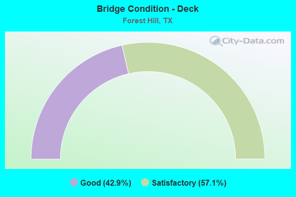
- Bridge Condition - Deck
- 42.9%Good
- 57.1%Satisfactory
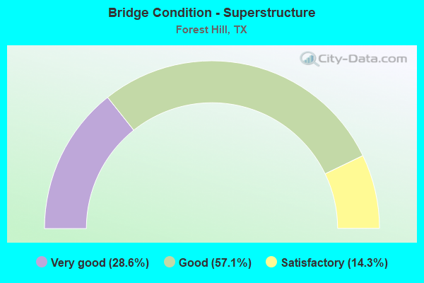
- Bridge Condition - Superstructure
- 28.6%Very good
- 57.1%Good
- 14.3%Satisfactory

- Bridge Condition - Substructure
- 28.6%Very good
- 57.1%Good
- 14.3%Satisfactory
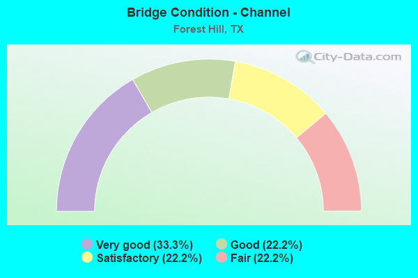
- Bridge Condition - Channel
- 33.3%Very good
- 22.2%Good
- 22.2%Satisfactory
- 22.2%Fair
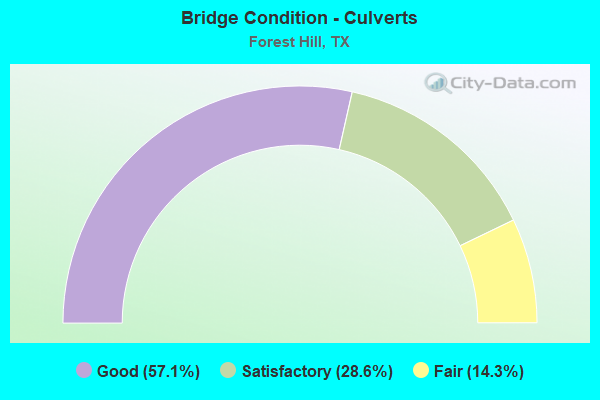
- Bridge Condition - Culverts
- 57.1%Good
- 28.6%Satisfactory
- 14.3%Fair
Find on map >> Show street view
Structure Number: 22200000813092, Location: 0.20 MI W OF BU 287 (Lat: 32.662989, Lng: -97.244661), Route carried "on" structure: Interstate 20, Year Built: 1960, Year Reconstructed: 1988, Status: Open, Structure Length: 10.21m (33.50ft), Average Daily Traffic: 83,304 (year 2019), Truck Traffic: 1%, Average Future Daily Traffic: 113,700 (year 2033), Design Load: HS 20, Features Intersected: UNION PACIFIC RAILROAD
Minimum Vertical Clearance: 30+ m (98+ ft), Kilometerpoint: 22.402, Lanes on structure: 6, Base Highway Network: Yes, Owner: State Highway Agency, Approaching Roadway Width: 28.0m (91.9ft), Skew: 2 degrees, Material/Design: Steel continuous, Design/Construction: Stringer/Multi-beam, Number Of Spans In Main Unit: 3, Number Of Approach Spans: 2, Length of Maximum Span: 22.9m (75.1ft), Curb-To-Curb Width: 28.0m (91.9ft), Out-to-Out Width: 28.7m (94.2ft)
Condition: Deck: Satisfactory, Superstructure: Good, Substructure: Good, Operating Rating: 54.4 metric tons, Method Used To Determine Operating Rating: Load Factor (LF), Inventory Rating: 32.7 metric tons, Method Used To Determine Inventory Rating: Load Factor (LF), Structural Evaluation: Better than present minimum criteria, Deck Geometry: Equal to present minimum criteria, Underclear: Somewhat better than minimum adequacy, Approach Roadway Alignment: Equal to present desirable criteria, Designated Inspection Frequency: Every 24 months, Inspection Date: June 2021, Deck Structure Type: Concrete Cast-file-Place, Wearing Surface/Protective System: Wearing Surface: Bituminous
Find on map >> Show street view
Structure Number: 22200000813338, Location: 0.25 MI E OF WICHITA ST (Lat: 32.661058, Lng: -97.277219), Route carried "on" structure: Interstate 20, Year Built: 1989, Status: Open, Structure Length: 1.31m (4.30ft), Average Daily Traffic: 154,832 (year 2020), Truck Traffic: 1%, Average Future Daily Traffic: 227,410 (year 2033), Design Load: HS 20, Features Intersected: TRIB OF SYCAMORE CR
Minimum Vertical Clearance: 30+ m (98+ ft), Kilometerpoint: 19.307, Lanes on structure: 16, Base Highway Network: Yes, Owner: State Highway Agency, Approaching Roadway Width: 76.8m (252.0ft), Skew: 34 degrees, Material/Design: Concrete, Design/Construction: Culvert, Number Of Spans In Main Unit: 4, Length of Maximum Span: 1.8m (5.9ft)
Condition: Channel: Good, Culverts: Good, Operating Rating: 39.9 metric tons, Method Used To Determine Operating Rating: Load Factor (LF), Inventory Rating: 23.6 metric tons, Method Used To Determine Inventory Rating: Load Factor (LF), Structural Evaluation: Somewhat better than minimum adequacy, Waterway Adequacy: Equal to present minimum criteria, Approach Roadway Alignment: Equal to present desirable criteria, Designated Inspection Frequency: Every 24 months, Inspection Date: June 2021
Find on map >> Show street view
Structure Number: 22200000813341, Location: 2.45 MI E OF IH 35W (Lat: 32.661536, Lng: -97.281347), Route carried "on" structure: Interstate 20, Year Built: 1988, Status: Open, Structure Length: 6.80m (22.31ft), Average Daily Traffic: 154,832 (year 2020), Truck Traffic: 1%, Average Future Daily Traffic: 227,480 (year 2033), Design Load: HS 20, Features Intersected: WICHITA ST
Minimum Vertical Clearance: 30+ m (98+ ft), Kilometerpoint: 18.950, Lanes on structure: 9, Lanes under structure: 6, Base Highway Network: Yes, Owner: State Highway Agency, Approaching Roadway Width: 45.1m (148.0ft), Skew: 31 degrees, Material/Design: Prestressed concrete, Design/Construction: Stringer/Multi-beam, Number Of Spans In Main Unit: 3, Length of Maximum Span: 24.4m (80.1ft), Curb-To-Curb Width: 45.1m (148.0ft), Out-to-Out Width: 46.9m (153.9ft)
Condition: Deck: Satisfactory, Superstructure: Satisfactory, Substructure: Good, Operating Rating: 54.4 metric tons, Method Used To Determine Operating Rating: Assigned rating based on Load Factor Design (LFD) reported in metric tons, Inventory Rating: 32.7 metric tons, Method Used To Determine Inventory Rating: Assigned rating based on Load Factor Design (LFD) reported in metric tons, Structural Evaluation: Equal to present minimum criteria, Deck Geometry: Superior to present desirable criteria, Underclear: High priority of corrective action, Approach Roadway Alignment: Equal to present desirable criteria, Designated Inspection Frequency: Every 24 months, Inspection Date: June 2021, Deck Structure Type: Concrete Cast-file-Place
Find on map >> Show street view
Structure Number: 22200000813342, Location: 3.10 MI E OF IH 35W (Lat: 32.661508, Lng: -97.269856), Route carried "on" structure: Interstate 20, Year Built: 1988, Status: Open, Structure Length: 6.64m (21.78ft), Average Daily Traffic: 154,832 (year 2020), Truck Traffic: 1%, Average Future Daily Traffic: 227,410 (year 2033), Design Load: HS 20, Features Intersected: FOREST HILL DR
Minimum Vertical Clearance: 30+ m (98+ ft), Kilometerpoint: 20.023, Lanes on structure: 9, Lanes under structure: 6, Base Highway Network: Yes, Owner: State Highway Agency, Approaching Roadway Width: 45.1m (148.0ft), Skew: 30 degrees, Material/Design: Prestressed concrete, Design/Construction: Stringer/Multi-beam, Number Of Spans In Main Unit: 3, Length of Maximum Span: 21.9m (71.9ft), Curb-To-Curb Width: 45.1m (148.0ft), Out-to-Out Width: 46.9m (153.9ft)
Condition: Deck: Satisfactory, Superstructure: Good, Substructure: Good, Operating Rating: 54.4 metric tons, Method Used To Determine Operating Rating: Assigned rating based on Load Factor Design (LFD) reported in metric tons, Inventory Rating: 32.7 metric tons, Method Used To Determine Inventory Rating: Assigned rating based on Load Factor Design (LFD) reported in metric tons, Structural Evaluation: Better than present minimum criteria, Deck Geometry: Superior to present desirable criteria, Underclear: Equal to present minimum criteria, Approach Roadway Alignment: Equal to present desirable criteria, Designated Inspection Frequency: Every 24 months, Inspection Date: June 2021, Deck Structure Type: Concrete Cast-file-Place
Find on map >> Show street view
Structure Number: 22200000813343, Location: 0.60 MI E OF FOREST HLL (Lat: 32.661486, Lng: -97.260044), Route carried "on" structure: Interstate 20, Year Built: 1988, Status: Open, Structure Length: 4.94m (16.21ft), Average Daily Traffic: 154,832 (year 2020), Truck Traffic: 1%, Average Future Daily Traffic: 227,410 (year 2033), Design Load: HS 20, Features Intersected: HARTMAN RD
Minimum Vertical Clearance: 30+ m (98+ ft), Kilometerpoint: 20.952, Lanes on structure: 10, Lanes under structure: 2, Base Highway Network: Yes, Owner: State Highway Agency, Approaching Roadway Width: 48.8m (160.1ft), Skew: 30 degrees, Material/Design: Prestressed concrete, Design/Construction: Stringer/Multi-beam, Number Of Spans In Main Unit: 3, Length of Maximum Span: 18.0m (59.1ft), Curb-To-Curb Width: 49.0m (160.8ft), Out-to-Out Width: 50.6m (166.0ft)
Condition: Deck: Satisfactory, Superstructure: Good, Substructure: Satisfactory, Operating Rating: 54.4 metric tons, Method Used To Determine Operating Rating: Assigned rating based on Load Factor Design (LFD) reported in metric tons, Inventory Rating: 32.7 metric tons, Method Used To Determine Inventory Rating: Assigned rating based on Load Factor Design (LFD) reported in metric tons, Structural Evaluation: Equal to present minimum criteria, Deck Geometry: Superior to present desirable criteria, Underclear: Equal to present minimum criteria, Approach Roadway Alignment: Equal to present desirable criteria, Designated Inspection Frequency: Every 24 months, Inspection Date: June 2021, Deck Structure Type: Concrete Cast-file-Place
Find on map >> Show street view
Structure Number: 22200000813344, Location: 0.75 MI W OF BU 287 (Lat: 32.661456, Lng: -97.252569), Route carried "on" structure: City street 692, Year Built: 1988, Status: Open, Structure Length: 4.79m (15.72ft), Average Daily Traffic: 7,592 (year 2019), Average Future Daily Traffic: 5,250 (year 2031), Design Load: HS 20, Features Intersected: IH 20, Facility Carried by Structure: ANGLIN DR
Minimum Vertical Clearance: 30+ m (98+ ft), Kilometerpoint: 2.575, Lanes on structure: 4, Lanes under structure: 9, Base Highway Network: Yes, Owner: State Highway Agency, Approaching Roadway Width: 15.9m (52.2ft), Material/Design: Prestressed concrete, Design/Construction: Stringer/Multi-beam, Number Of Spans In Main Unit: 2, Length of Maximum Span: 25.6m (84.0ft), Curb or Sidewalk Widths: Left: 1.8m (5.9ft), Right: 1.8m (5.9ft), Curb-To-Curb Width: 15.9m (52.2ft), Out-to-Out Width: 20.1m (65.9ft)
Condition: Deck: Good, Superstructure: Good, Substructure: Good, Operating Rating: 54.4 metric tons, Method Used To Determine Operating Rating: Assigned rating based on Load Factor Design (LFD) reported in metric tons, Inventory Rating: 32.7 metric tons, Method Used To Determine Inventory Rating: Assigned rating based on Load Factor Design (LFD) reported in metric tons, Structural Evaluation: Better than present minimum criteria, Deck Geometry: Meets minimum limits, Underclear: High priority of corrective action, Approach Roadway Alignment: Equal to present desirable criteria, Length Of Structure Improvement: 4.79m (15.72ft), Designated Inspection Frequency: Every 24 months, Inspection Date: June 2021, Bridge Improvement Cost: $16,000, Roadway Improvement Cost: $4,000, Total Project Cost: $20,000, Deck Structure Type: Concrete Cast-file-Place, Wearing Surface/Protective System: Deck Protection: Epoxy Coated Reinforcing
Find on map >> Show street view
Structure Number: 22200017201226, Location: 0.20 MI NW OF IH 20 (Lat: 32.667039, Lng: -97.244803), Route carried "on" structure: Business State highway 287, Year Built: 2005, Status: Open, Structure Length: 1.13m (3.71ft), Average Daily Traffic: 11,460 (year 2013), Truck Traffic: 6%, Average Future Daily Traffic: 16,040 (year 2033), Design Load: HS 20, Features Intersected: WRAY BRANCH
Minimum Vertical Clearance: 30+ m (98+ ft), Kilometerpoint: 15.723, Lanes on structure: 6, Owner: State Highway Agency, Approaching Roadway Width: 26.2m (86.0ft), Skew: 4 degrees, Material/Design: Concrete, Design/Construction: Culvert, Number Of Spans In Main Unit: 3, Length of Maximum Span: 2.4m (7.9ft), Curb-To-Curb Width: 26.2m (86.0ft), Out-to-Out Width: 36.0m (118.1ft)
Condition: Channel: Good, Culverts: Good, Operating Rating: 54.4 metric tons, Method Used To Determine Operating Rating: Assigned rating based on Load Factor Design (LFD) reported in metric tons, Inventory Rating: 32.7 metric tons, Method Used To Determine Inventory Rating: Assigned rating based on Load Factor Design (LFD) reported in metric tons, Structural Evaluation: Better than present minimum criteria, Deck Geometry: Equal to present minimum criteria, Waterway Adequacy: Equal to present minimum criteria, Approach Roadway Alignment: Equal to present desirable criteria, Designated Inspection Frequency: Every 24 months, Inspection Date: June 2021, Deck Structure Type: Concrete Cast-file-Place, Wearing Surface/Protective System: Wearing Surface: Monolithic Concrete
Find on map >> Show street view
Structure Number: 22200L00355339, Location: 0.20 MI E OF WICHITA (Lat: 32.660114, Lng: -97.276536), Route carried "on" structure: City street , Year Built: 1987, Year Reconstructed: 1997, Status: Open, Structure Length: 1.19m (3.90ft), Average Daily Traffic: 3,621 (year 2019), Truck Traffic: 20%, Average Future Daily Traffic: 6,450 (year 2034), Design Load: HS 20, Features Intersected: NORTH FRK OF SOUTH CREEK, Facility Carried by Structure: FOREST HILL CIRCLE
Minimum Vertical Clearance: 30+ m (98+ ft), Kilometerpoint: 0.322, Lanes on structure: 5, Owner: City or Municipal Highway Agency, Approaching Roadway Width: 17.1m (56.1ft), Material/Design: Concrete, Design/Construction: Culvert, Number Of Spans In Main Unit: 4, Length of Maximum Span: 2.4m (7.9ft), Curb-To-Curb Width: 17.1m (56.1ft), Out-to-Out Width: 23.2m (76.1ft)
Condition: Channel: Very good, Culverts: Satisfactory, Operating Rating: 39.9 metric tons, Method Used To Determine Operating Rating: Load Factor (LF), Inventory Rating: 23.6 metric tons, Method Used To Determine Inventory Rating: Load Factor (LF), Structural Evaluation: Equal to present minimum criteria, Deck Geometry: High priority of replacement, Waterway Adequacy: Better than present minimum criteria, Approach Roadway Alignment: Equal to present desirable criteria, Designated Inspection Frequency: Every 24 months, Inspection Date: Febuary 2020, Wearing Surface/Protective System: Wearing Surface: Monolithic Concrete
Find on map >> Show street view
Structure Number: 22200L0035534, Location: 0.55 MI E OF WICHITA (Lat: 32.660028, Lng: -97.254314), Route carried "on" structure: City street , Year Built: 1987, Year Reconstructed: 1997, Status: Open, Structure Length: 1.13m (3.71ft), Average Daily Traffic: 4,934 (year 2014), Truck Traffic: 20%, Average Future Daily Traffic: 5,400 (year 2034), Design Load: HS 20, Features Intersected: N BR OF N FRK OF S CREEK, Facility Carried by Structure: FOREST HILL CIRCLE
Minimum Vertical Clearance: 30+ m (98+ ft), Kilometerpoint: 0.885, Lanes on structure: 5, Owner: City or Municipal Highway Agency, Approaching Roadway Width: 17.1m (56.1ft), Material/Design: Concrete, Design/Construction: Culvert, Number Of Spans In Main Unit: 5, Length of Maximum Span: 2.1m (6.9ft), Curb-To-Curb Width: 17.1m (56.1ft), Out-to-Out Width: 22.6m (74.1ft)
Condition: Channel: Satisfactory, Culverts: Good, Operating Rating: 39.9 metric tons, Method Used To Determine Operating Rating: Load Factor (LF), Inventory Rating: 23.6 metric tons, Method Used To Determine Inventory Rating: Load Factor (LF), Structural Evaluation: Equal to present minimum criteria, Deck Geometry: High priority of replacement, Waterway Adequacy: Equal to present desirable criteria, Approach Roadway Alignment: Equal to present desirable criteria, Designated Inspection Frequency: Every 24 months, Inspection Date: Febuary 2020, Wearing Surface/Protective System: Wearing Surface: Bituminous
Find on map >> Show street view
Structure Number: 22200L00365005, Location: 0.40 Mi. S. of IH20 EBFR (Lat: 32.655447, Lng: -97.269867), Route carried "on" structure: City street , Year Built: 2015, Status: Open, Structure Length: 1.68m (5.51ft), Average Daily Traffic: 17,305 (year 2019), Average Future Daily Traffic: 25,436 (year 2035), Design Load: HL 93, Features Intersected: Trib. of Village Ck., Facility Carried by Structure: Forest Hill Drive
Minimum Vertical Clearance: 30+ m (98+ ft), Kilometerpoint: 0.805, Lanes on structure: 2, Owner: City or Municipal Highway Agency, Approaching Roadway Width: 7.3m (24.0ft), Skew: 1 degrees, Material/Design: Prestressed concrete, Design/Construction: Slab, Number Of Spans In Main Unit: 2, Length of Maximum Span: 9.1m (29.9ft), Curb or Sidewalk Widths: Left: 2.0m (6.6ft), Right: 0.0m, Curb-To-Curb Width: 7.3m (24.0ft), Out-to-Out Width: 10.6m (34.8ft)
Condition: Deck: Good, Superstructure: Very good, Substructure: Very good, Channel: Very good, Operating Rating: 54.4 metric tons, Method Used To Determine Operating Rating: Assigned ratings based on Load and Resistance Factor Design (LRFD) reported in metric tons, Inventory Rating: 32.7 metric tons, Method Used To Determine Inventory Rating: Assigned ratings based on Load and Resistance Factor Design (LRFD) reported in metric tons, Structural Evaluation: Equal to present desirable criteria, Deck Geometry: High priority of replacement, Waterway Adequacy: Better than present minimum criteria, Approach Roadway Alignment: Equal to present desirable criteria, Designated Inspection Frequency: Every 24 months, Inspection Date: Febuary 2020, Deck Structure Type: Concrete Cast-file-Place, Wearing Surface/Protective System: Deck Protection: Epoxy Coated Reinforcing
Find on map >> Show street view
Structure Number: 22200L00365006, Location: 0.45 Mi. S. of IH20 EBFR (Lat: 32.654517, Lng: -97.269858), Route carried "on" structure: City street , Year Built: 2015, Status: Open, Structure Length: 2.29m (7.51ft), Average Daily Traffic: 16,094 (year 2019), Average Future Daily Traffic: 25,426 (year 2035), Design Load: HL 93, Features Intersected: Village Creek, Facility Carried by Structure: Forest Hill Drive
Minimum Vertical Clearance: 30+ m (98+ ft), Kilometerpoint: 0.966, Lanes on structure: 5, Owner: City or Municipal Highway Agency, Approaching Roadway Width: 7.3m (24.0ft), Material/Design: Prestressed concrete, Design/Construction: Slab, Number Of Spans In Main Unit: 2, Length of Maximum Span: 12.2m (40.0ft), Curb or Sidewalk Widths: Left: 2.0m (6.6ft), Right: 0.0m, Curb-To-Curb Width: 7.3m (24.0ft), Out-to-Out Width: 10.6m (34.8ft)
Condition: Deck: Good, Superstructure: Very good, Substructure: Very good, Channel: Very good, Operating Rating: 54.4 metric tons, Method Used To Determine Operating Rating: Assigned ratings based on Load and Resistance Factor Design (LRFD) reported in metric tons, Inventory Rating: 32.7 metric tons, Method Used To Determine Inventory Rating: Assigned ratings based on Load and Resistance Factor Design (LRFD) reported in metric tons, Structural Evaluation: Equal to present desirable criteria, Deck Geometry: High priority of replacement, Waterway Adequacy: Better than present minimum criteria, Approach Roadway Alignment: Equal to present desirable criteria, Designated Inspection Frequency: Every 24 months, Inspection Date: Febuary 2020, Deck Structure Type: Concrete Cast-file-Place, Wearing Surface/Protective System: Deck Protection: Epoxy Coated Reinforcing
Find on map >> Show street view
Structure Number: 22200L00945001, Location: 0.1 MI S OF VALLEY FORGE (Lat: 32.651725, Lng: -97.277322), Route carried "on" structure: City street , Year Built: 1974, Status: Posted for load, Structure Length: 1.68m (5.51ft), Average Daily Traffic: 1,360 (year 2014), Truck Traffic: 2%, Average Future Daily Traffic: 1,410 (year 2034), Features Intersected: SOUTH CREEK, Facility Carried by Structure: STONEWALL ROAD
Minimum Vertical Clearance: 30+ m (98+ ft), Kilometerpoint: 5.633, Lanes on structure: 2, Owner: City or Municipal Highway Agency, Approaching Roadway Width: 9.1m (29.9ft), Skew: 1 degrees, Material/Design: Concrete, Design/Construction: Culvert, Number Of Spans In Main Unit: 6, Length of Maximum Span: 2.4m (7.9ft), Curb-To-Curb Width: 9.3m (30.5ft), Out-to-Out Width: 9.6m (31.5ft)
Condition: Channel: Fair, Culverts: Fair, Operating Rating: 32.7 metric tons, Method Used To Determine Operating Rating: Field evaluation and documented engineering judgment, Inventory Rating: 24.5 metric tons, Method Used To Determine Inventory Rating: Field evaluation and documented engineering judgment, Structural Evaluation: Somewhat better than minimum adequacy, Deck Geometry: Somewhat better than minimum adequacy, Waterway Adequacy: Equal to present minimum criteria, Approach Roadway Alignment: Better than present minimum criteria, Designated Inspection Frequency: Every 24 months, Inspection Date: Febuary 2020, Wearing Surface/Protective System: Wearing Surface: Monolithic Concrete
Find on map >> Show street view
Structure Number: 22200L01025001, Location: 0.1 MI N OF IH 20 (Lat: 32.663208, Lng: -97.280869), Route carried "on" structure: City street , Year Built: 1979, Status: Open, Structure Length: 0.79m (2.59ft), Average Daily Traffic: 17,591 (year 2019), Average Future Daily Traffic: 20,700 (year 2034), Features Intersected: NORTH FRK OF SOUTH CREEK, Facility Carried by Structure: WICHITA ST
Minimum Vertical Clearance: 30+ m (98+ ft), Kilometerpoint: 24.784, Lanes on structure: 5, Owner: City or Municipal Highway Agency, Approaching Roadway Width: 18.9m (62.0ft), Material/Design: Concrete, Design/Construction: Culvert, Number Of Spans In Main Unit: 3, Length of Maximum Span: 2.4m (7.9ft), Curb or Sidewalk Widths: Left: 0.8m (2.6ft), Right: 0.8m (2.6ft), Curb-To-Curb Width: 18.9m (62.0ft), Out-to-Out Width: 24.4m (80.1ft)
Condition: Channel: Fair, Culverts: Satisfactory, Operating Rating: 32.7 metric tons, Method Used To Determine Operating Rating: Field evaluation and documented engineering judgment, Inventory Rating: 24.5 metric tons, Method Used To Determine Inventory Rating: Field evaluation and documented engineering judgment, Structural Evaluation: Equal to present minimum criteria, Deck Geometry: Meets minimum limits, Waterway Adequacy: High priority of corrective action, Approach Roadway Alignment: Equal to present desirable criteria, Length Of Structure Improvement: 0.76m (2.49ft), Designated Inspection Frequency: Every 24 months, Inspection Date: Febuary 2020, Bridge Improvement Cost: $31,000, Roadway Improvement Cost: $8,000, Total Project Cost: $39,000, Wearing Surface/Protective System: Wearing Surface: Monolithic Concrete
Find on map >> Show street view
Structure Number: 22200L01025002, Location: 0.5 MI S OF IH 20 (Lat: 32.653572, Lng: -97.283525), Route carried "on" structure: City street , Year Built: 2000, Status: Open, Structure Length: 0.91m (2.99ft), Average Daily Traffic: 12,324 (year 2019), Average Future Daily Traffic: 15,430 (year 2034), Design Load: HS 20, Features Intersected: SOUTH CREEK, Facility Carried by Structure: WICHITA STREET
Minimum Vertical Clearance: 30+ m (98+ ft), Kilometerpoint: 25.927, Lanes on structure: 2, Owner: City or Municipal Highway Agency, Approaching Roadway Width: 7.9m (25.9ft), Material/Design: Concrete, Design/Construction: Culvert, Number Of Spans In Main Unit: 4, Length of Maximum Span: 2.1m (6.9ft), Curb-To-Curb Width: 9.1m (29.9ft), Out-to-Out Width: 9.8m (32.2ft)
Condition: Channel: Satisfactory, Culverts: Good, Operating Rating: 54.4 metric tons, Method Used To Determine Operating Rating: Assigned rating based on Load Factor Design (LFD) reported in metric tons, Inventory Rating: 32.7 metric tons, Method Used To Determine Inventory Rating: Assigned rating based on Load Factor Design (LFD) reported in metric tons, Structural Evaluation: Better than present minimum criteria, Deck Geometry: High priority of corrective action, Waterway Adequacy: Equal to present desirable criteria, Approach Roadway Alignment: Equal to present desirable criteria, Length Of Structure Improvement: 0.91m (2.99ft), Designated Inspection Frequency: Every 24 months, Inspection Date: Febuary 2020, Bridge Improvement Cost: $2,000, Roadway Improvement Cost: $1,000, Total Project Cost: $3,000, Wearing Surface/Protective System: Wearing Surface: Bituminous
Find on map >> Show street view
Structure Number: 22200000813341, Location: 2.45 MI E OF IH 35W (Lat: 32.661536, Lng: -97.281347), Route carried "under" structure: City street 1025, Year Built: 1988, Structure Length: 0. m, Average Daily Traffic: 19,215 (year 2011), Features Intersected: WICHITA ST, Facility Carried by Structure: IH 20
Minimum Vertical Clearance: 4.72m (15.49ft), Kilometerpoint: 25.267, Lanes on structure: 9, Lanes under structure: 6, Material/Design: Prestressed concrete, Design/Construction: Stringer/Multi-beam, Length of Maximum Span: 24.4m (80.1ft)
Find on map >> Show street view
Structure Number: 22200000813342, Location: 3.10 MI E OF IH 35W (Lat: 32.661508, Lng: -97.269856), Route carried "under" structure: City street 691, Year Built: 1988, Structure Length: 0. m, Average Daily Traffic: 19,960 (year 2011), Features Intersected: FOREST HILL DR, Facility Carried by Structure: IH 20
Minimum Vertical Clearance: 5.01m (16.44ft), Kilometerpoint: 1.658, Lanes on structure: 9, Lanes under structure: 6, Material/Design: Prestressed concrete, Design/Construction: Stringer/Multi-beam, Length of Maximum Span: 21.9m (71.9ft)
Find on map >> Show street view
Structure Number: 22200000813343, Location: 0.60 MI E OF FOREST HLL (Lat: 32.661486, Lng: -97.260044), Route carried "under" structure: City street , Year Built: 1988, Structure Length: 0. m, Average Daily Traffic: 2,105 (year 2011), Features Intersected: HARTMAN RD, Facility Carried by Structure: IH 20
Minimum Vertical Clearance: 4.70m (15.42ft), Kilometerpoint: 1.931, Lanes on structure: 10, Lanes under structure: 2, Material/Design: Prestressed concrete, Design/Construction: Stringer/Multi-beam, Length of Maximum Span: 18.0m (59.1ft)
Find on map >> Show street view
Structure Number: 22200000813344, Location: 0.75 MI W OF BU 287 (Lat: 32.661456, Lng: -97.252569), Route carried "under" structure: Interstate 20, Year Built: 1988, Structure Length: 0. m, Average Daily Traffic: 162,430 (year 2013), Truck Traffic: 1%, Features Intersected: IH 20, Facility Carried by Structure: ANGLIN DR
Minimum Vertical Clearance: 5.36m (17.59ft), Kilometerpoint: 21.675, Lanes on structure: 4, Lanes under structure: 9, Material/Design: Prestressed concrete, Design/Construction: Stringer/Multi-beam, Length of Maximum Span: 25.6m (84.0ft)