Bridge Statistics for Forest, Louisiana (LA)
Condition, Traffic, Stress, Structural Evaluation, Project Costs
- National Bridge Inventory (NBI) Statistics
- 10Number of bridges
- 52ft / 16.1mTotal length
- $643,000Total costs
- 4,875Total average daily traffic
- 492Total average daily truck traffic
- 3,027Total future (year 2036) average daily traffic
- National Bridge Inventory (NBI) Registered Bridges for Forest
- No street view available for this location
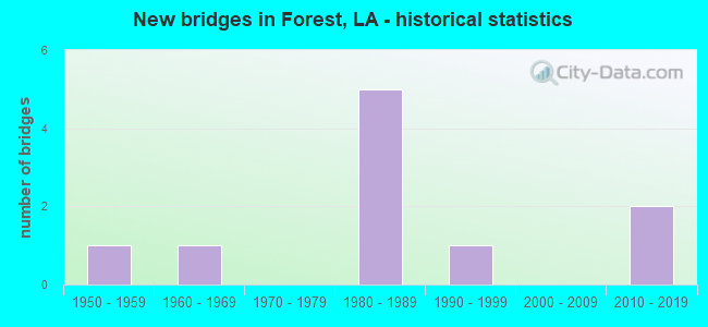
- New bridges - historical statistics
- 11950-1959
- 11960-1969
- 51980-1989
- 11990-1999
- 22010-2019

- Bridge Condition - Deck
- 50.0%Good
- 16.7%Satisfactory
- 33.3%Poor

- Bridge Condition - Superstructure
- 50.0%Good
- 16.7%Satisfactory
- 33.3%Poor

- Bridge Condition - Substructure
- 50.0%Good
- 16.7%Fair
- 33.3%Poor

- Bridge Condition - Channel
- 10.0%Good
- 80.0%Satisfactory
- 10.0%Serious

- Bridge Condition - Culverts
- 25.0%Good
- 75.0%Satisfactory
Find on map >> Show street view
Structure Number: 56200000050281, Location: 2.0 MI NE OF LA 589 (Lat: 32.809469, Lng: -91.395519), Route carried "on" structure: County highway , Year Built: 2016, Status: Open, Structure Length: 1.01m (3.31ft), Average Daily Traffic: 384 (year 2019), Average Future Daily Traffic: 450 (year 2037), Design Load: Greater than HL93, Features Intersected: LYON BAYOU, Facility Carried by Structure: Odis Wade Rd
Minimum Vertical Clearance: 30+ m (98+ ft), Kilometerpoint: 0.000, Lanes on structure: 2, Owner: County Highway Agency, Approaching Roadway Width: 6.7m (22.0ft), Skew: 1 degrees, Material/Design: Concrete, Design/Construction: Culvert, Number Of Spans In Main Unit: 4, Length of Maximum Span: 2.1m (6.9ft), Curb-To-Curb Width: 6.7m (22.0ft), Out-to-Out Width: 16.5m (54.1ft)
Condition: Channel: Serious, Culverts: Good, Operating Rating: 42.1 metric tons, Method Used To Determine Operating Rating: Load and Resistance Factor Rating (LRFR) rating reported by rating factor(RF) method using HL-93 loadings, Inventory Rating: 32.4 metric tons, Method Used To Determine Inventory Rating: Load and Resistance Factor Rating (LRFR) rating reported by rating factor(RF) method using HL-93 loadings, Structural Evaluation: Better than present minimum criteria, Deck Geometry: Meets minimum limits, Waterway Adequacy: Equal to present desirable criteria, Approach Roadway Alignment: Equal to present minimum criteria, Designated Inspection Frequency: Every 24 months, Inspection Date: Febuary 2021
Find on map >> Show street view
Structure Number: 56200000400191, Location: .25 MILES EAST OF LA 589 (Lat: 32.809639, Lng: -91.369069), Route carried "on" structure: County highway , Year Built: 2010, Status: Open, Structure Length: 1.83m (6.00ft), Average Daily Traffic: 16 (year 2019), Average Future Daily Traffic: 30 (year 2036), Design Load: HS 20, Features Intersected: LYON BAYOU, Facility Carried by Structure: Lingo Lp
Minimum Vertical Clearance: 30+ m (98+ ft), Kilometerpoint: 0.000, Lanes on structure: 2, Owner: County Highway Agency, Approaching Roadway Width: 3.7m (12.1ft), Skew: 30 degrees, Material/Design: Concrete, Design/Construction: Slab, Number Of Spans In Main Unit: 3, Length of Maximum Span: 6.1m (20.0ft), Curb-To-Curb Width: 8.5m (27.9ft), Out-to-Out Width: 9.3m (30.5ft)
Condition: Deck: Good, Superstructure: Good, Substructure: Good, Channel: Satisfactory, Operating Rating: 44.7 metric tons, Method Used To Determine Operating Rating: Load and Resistance Factor Rating (LRFR) rating reported by rating factor(RF) method using HL-93 loadings, Inventory Rating: 34.3 metric tons, Method Used To Determine Inventory Rating: Load and Resistance Factor Rating (LRFR) rating reported by rating factor(RF) method using HL-93 loadings, Structural Evaluation: Better than present minimum criteria, Deck Geometry: Better than present minimum criteria, Waterway Adequacy: Equal to present desirable criteria, Approach Roadway Alignment: Equal to present desirable criteria, Designated Inspection Frequency: Every 24 months, Inspection Date: Febuary 2021, Deck Structure Type: Concrete Cast-file-Place, Wearing Surface/Protective System: Wearing Surface: Monolithic Concrete
Find on map >> Show street view
Structure Number: 56203320100261, Location: .26 MI WEST OF LA 2 (Lat: 32.827531, Lng: -91.462900), Route carried "on" structure: State highway 878, Year Built: 1980, Status: Open, Structure Length: 1.74m (5.71ft), Average Daily Traffic: 370 (year 2016), Truck Traffic: 19%, Average Future Daily Traffic: 264 (year 2036), Design Load: HS 20, Features Intersected: LITTLE COLEWA BAYOU
Minimum Vertical Clearance: 30+ m (98+ ft), Kilometerpoint: 0.412, Lanes on structure: 2, Owner: State Highway Agency, Approaching Roadway Width: 10.4m (34.1ft), Material/Design: Concrete, Design/Construction: Slab, Number Of Spans In Main Unit: 3, Length of Maximum Span: 5.8m (19.0ft), Curb-To-Curb Width: 9.8m (32.2ft), Out-to-Out Width: 10.7m (35.1ft)
Condition: Deck: Satisfactory, Superstructure: Satisfactory, Substructure: Fair, Channel: Satisfactory, Operating Rating: 65.3 metric tons, Method Used To Determine Operating Rating: Load Factor (LF), Inventory Rating: 39.0 metric tons, Method Used To Determine Inventory Rating: Load Factor (LF), Structural Evaluation: Somewhat better than minimum adequacy, Deck Geometry: Better than present minimum criteria, Waterway Adequacy: Better than present minimum criteria, Approach Roadway Alignment: Equal to present minimum criteria, Designated Inspection Frequency: Every 24 months, Inspection Date: January 2021, Deck Structure Type: Concrete Precast Panels, Wearing Surface/Protective System: Wearing Surface: Monolithic Concrete
Find on map >> Show street view
Structure Number: 56203330200401, Location: 0.4 MI E of LA 17 (Lat: 32.783639, Lng: -91.408100), Route carried "on" structure: State highway 582, Year Built: 1983, Status: Open, Structure Length: 2.44m (8.01ft), Average Daily Traffic: 700 (year 2016), Truck Traffic: 19%, Average Future Daily Traffic: 576 (year 2036), Design Load: HS 20, Features Intersected: LYON BAYOU
Minimum Vertical Clearance: 30+ m (98+ ft), Kilometerpoint: 0.639, Lanes on structure: 2, Owner: State Highway Agency, Approaching Roadway Width: 9.1m (29.9ft), Material/Design: Concrete, Design/Construction: Slab, Number Of Spans In Main Unit: 4, Length of Maximum Span: 6.1m (20.0ft), Curb-To-Curb Width: 9.1m (29.9ft), Out-to-Out Width: 10.1m (33.1ft)
Condition: Deck: Good, Superstructure: Good, Substructure: Good, Channel: Satisfactory, Operating Rating: 68.0 metric tons, Method Used To Determine Operating Rating: Load Factor (LF), Inventory Rating: 40.8 metric tons, Method Used To Determine Inventory Rating: Load Factor (LF), Structural Evaluation: Better than present minimum criteria, Deck Geometry: Equal to present minimum criteria, Waterway Adequacy: Better than present minimum criteria, Approach Roadway Alignment: Better than present minimum criteria, Designated Inspection Frequency: Every 24 months, Inspection Date: January 2021, Deck Structure Type: Concrete Cast-file-Place, Wearing Surface/Protective System: Wearing Surface: Monolithic Concrete
Find on map >> Show street view
Structure Number: 56203330202601, Location: 2.6 MI E of LA 17 (Lat: 32.773000, Lng: -91.374400), Route carried "on" structure: State highway 582, Year Built: 1983, Status: Open, Structure Length: 3.05m (10.01ft), Average Daily Traffic: 700 (year 2016), Truck Traffic: 19%, Average Future Daily Traffic: 576 (year 2036), Design Load: HS 20, Features Intersected: MILL BAYOU
Minimum Vertical Clearance: 30+ m (98+ ft), Kilometerpoint: 4.139, Lanes on structure: 2, Owner: State Highway Agency, Approaching Roadway Width: 9.1m (29.9ft), Material/Design: Concrete, Design/Construction: Slab, Number Of Spans In Main Unit: 5, Length of Maximum Span: 6.1m (20.0ft), Curb-To-Curb Width: 9.1m (29.9ft), Out-to-Out Width: 10.1m (33.1ft)
Condition: Deck: Good, Superstructure: Good, Substructure: Good, Channel: Good, Operating Rating: 66.2 metric tons, Method Used To Determine Operating Rating: Load Factor (LF), Inventory Rating: 39.0 metric tons, Method Used To Determine Inventory Rating: Load Factor (LF), Structural Evaluation: Better than present minimum criteria, Deck Geometry: Equal to present minimum criteria, Waterway Adequacy: Equal to present desirable criteria, Approach Roadway Alignment: Equal to present desirable criteria, Designated Inspection Frequency: Every 24 months, Inspection Date: January 2021, Deck Structure Type: Concrete Cast-file-Place, Wearing Surface/Protective System: Wearing Surface: Monolithic Concrete
Find on map >> Show street view
Structure Number: 56208620601521, Location: 1.52 MI E of LA 582 (Lat: 32.798481, Lng: -91.466900), Route carried "on" structure: State highway 589, Year Built: 1981, Status: Open, Structure Length: 0.70m (2.30ft), Average Daily Traffic: 330 (year 2016), Truck Traffic: 15%, Average Future Daily Traffic: 240 (year 2036), Design Load: HS 20, Features Intersected: INDIAN LAKE
Minimum Vertical Clearance: 30+ m (98+ ft), Kilometerpoint: 2.408, Lanes on structure: 2, Owner: State Highway Agency, Approaching Roadway Width: 7.3m (24.0ft), Material/Design: Steel, Design/Construction: Culvert, Number Of Spans In Main Unit: 3, Length of Maximum Span: 1.8m (5.9ft)
Condition: Channel: Satisfactory, Culverts: Satisfactory, Operating Rating: 81.3 metric tons, Method Used To Determine Operating Rating: Load and Resistance Factor Rating (LRFR) rating reported by rating factor(RF) method using HL-93 loadings, Inventory Rating: 62.9 metric tons, Method Used To Determine Inventory Rating: Load and Resistance Factor Rating (LRFR) rating reported by rating factor(RF) method using HL-93 loadings, Structural Evaluation: Equal to present minimum criteria, Waterway Adequacy: Equal to present desirable criteria, Approach Roadway Alignment: Equal to present desirable criteria, Designated Inspection Frequency: Every 24 months, Inspection Date: Febuary 2021
Find on map >> Show street view
Structure Number: 56208620701971, Location: 1.97 MI W of LA 17 (Lat: 32.801889, Lng: -91.437700), Route carried "on" structure: State highway 589, Year Built: 1981, Status: Open, Structure Length: 1.13m (3.71ft), Average Daily Traffic: 330 (year 2016), Truck Traffic: 15%, Average Future Daily Traffic: 240 (year 2036), Design Load: HS 20, Features Intersected: DEER LAKE
Minimum Vertical Clearance: 30+ m (98+ ft), Kilometerpoint: 3.133, Lanes on structure: 2, Owner: State Highway Agency, Approaching Roadway Width: 7.3m (24.0ft), Material/Design: Steel, Design/Construction: Culvert, Number Of Spans In Main Unit: 4, Length of Maximum Span: 2.1m (6.9ft)
Condition: Channel: Satisfactory, Culverts: Satisfactory, Operating Rating: 97.2 metric tons, Method Used To Determine Operating Rating: Load and Resistance Factor Rating (LRFR) rating reported by rating factor(RF) method using HL-93 loadings, Inventory Rating: 74.5 metric tons, Method Used To Determine Inventory Rating: Load and Resistance Factor Rating (LRFR) rating reported by rating factor(RF) method using HL-93 loadings, Structural Evaluation: Equal to present minimum criteria, Waterway Adequacy: Better than present minimum criteria, Approach Roadway Alignment: Equal to present desirable criteria, Designated Inspection Frequency: Every 24 months, Inspection Date: Febuary 2021
Find on map >> Show street view
Structure Number: 56208621400641, Location: .6 MI EAST OF LA 17 (Lat: 32.791869, Lng: -91.403200), Route carried "on" structure: State highway 589, Year Built: 1957, Status: Posted for load, Structure Length: 1.74m (5.71ft), Average Daily Traffic: 390 (year 2016), Truck Traffic: 15%, Average Future Daily Traffic: 429 (year 2036), Design Load: H 15, Features Intersected: ALLIGATOR BAYOU
Minimum Vertical Clearance: 30+ m (98+ ft), Kilometerpoint: 1.024, Lanes on structure: 2, Owner: State Highway Agency, Approaching Roadway Width: 7.3m (24.0ft), Material/Design: Concrete, Design/Construction: Slab, Number Of Spans In Main Unit: 3, Length of Maximum Span: 5.8m (19.0ft), Curb-To-Curb Width: 7.3m (24.0ft), Out-to-Out Width: 8.3m (27.2ft)
Condition: Deck: Poor, Superstructure: Poor, Substructure: Poor, Channel: Satisfactory, Operating Rating: 14.9 metric tons, Method Used To Determine Operating Rating: Load and Resistance Factor Rating (LRFR) rating reported by rating factor(RF) method using HL-93 loadings, Inventory Rating: 11.7 metric tons, Method Used To Determine Inventory Rating: Load and Resistance Factor Rating (LRFR) rating reported by rating factor(RF) method using HL-93 loadings, Structural Evaluation: Meets minimum limits, Deck Geometry: Somewhat better than minimum adequacy, Waterway Adequacy: Better than present minimum criteria, Approach Roadway Alignment: Better than present minimum criteria, Bridge Posting: Required (Relationship of Operating Rating to Maximum Legal Load: > 39.9% below), Length Of Structure Improvement: 2.44m (8.01ft), Designated Inspection Frequency: Every 24 months, Other Special Inspection Frequency: Every 6 months, Inspection Date: January 2021, Other Special Inspection Date: January 2022, Bridge Improvement Cost: $208,000, Total Project Cost: $312,000 ( Estimate for 2016), Deck Structure Type: Concrete Precast Panels, Wearing Surface/Protective System: Wearing Surface: Bituminous
Find on map >> Show street view
Structure Number: 56232489912301, Location: 1.0 MI W of LA 589 (Lat: 32.814000, Lng: -91.383019), Route carried "on" structure: County highway , Year Built: 1990, Status: Open, Structure Length: 0.64m (2.10ft), Average Daily Traffic: 951 (year 2019), Average Future Daily Traffic: 90 (year 2036), Design Load: HS 20, Features Intersected: LYON BAYOU, Facility Carried by Structure: Skinner Ln
Minimum Vertical Clearance: 30+ m (98+ ft), Kilometerpoint: 0.000, Lanes on structure: 1, Owner: County Highway Agency, Approaching Roadway Width: 6.7m (22.0ft), Skew: 3 degrees, Material/Design: Steel, Design/Construction: Culvert, Number Of Spans In Main Unit: 2, Length of Maximum Span: 2.7m (8.9ft), Curb-To-Curb Width: 4.6m (15.1ft), Out-to-Out Width: 18.3m (60.0ft)
Condition: Channel: Satisfactory, Culverts: Satisfactory, Operating Rating: 52.5 metric tons, Method Used To Determine Operating Rating: Load and Resistance Factor Rating (LRFR) rating reported by rating factor(RF) method using HL-93 loadings, Inventory Rating: 40.5 metric tons, Method Used To Determine Inventory Rating: Load and Resistance Factor Rating (LRFR) rating reported by rating factor(RF) method using HL-93 loadings, Structural Evaluation: Equal to present minimum criteria, Deck Geometry: High priority of replacement, Waterway Adequacy: Equal to present desirable criteria, Approach Roadway Alignment: Equal to present minimum criteria, Length Of Structure Improvement: 1.25m (4.10ft), Designated Inspection Frequency: Every 24 months, Inspection Date: Febuary 2021, Bridge Improvement Cost: $74,000, Total Project Cost: $111,000 ( Estimate for 2016)
Find on map >> Show street view
Structure Number: 56232492912821, Location: .2 MI. W. HWY. 2 (Lat: 32.820389, Lng: -91.469761), Route carried "on" structure: County highway , Year Built: 1965, Status: Posted for load, Structure Length: 1.77m (5.81ft), Average Daily Traffic: 704 (year 2019), Average Future Daily Traffic: 132 (year 2036), Design Load: H 20, Features Intersected: LITTLE COLEWA BAYOU, Facility Carried by Structure: Roundhill Rd
Minimum Vertical Clearance: 4.88m (16.01ft), Kilometerpoint: 0.000, Lanes on structure: 2, Owner: County Highway Agency, Approaching Roadway Width: 8.2m (26.9ft), Material/Design: Wood or Timber, Design/Construction: Stringer/Multi-beam, Number Of Spans In Main Unit: 3, Length of Maximum Span: 5.8m (19.0ft), Curb-To-Curb Width: 6.9m (22.6ft), Out-to-Out Width: 7.3m (24.0ft)
Condition: Deck: Poor, Superstructure: Poor, Substructure: Poor, Channel: Satisfactory, Operating Rating: 24.5 metric tons, Method Used To Determine Operating Rating: Allowable Stress (AS), Inventory Rating: 19.0 metric tons, Method Used To Determine Inventory Rating: Allowable Stress (AS), Structural Evaluation: Meets minimum limits, Deck Geometry: Meets minimum limits, Waterway Adequacy: Equal to present desirable criteria, Approach Roadway Alignment: Equal to present desirable criteria, Length Of Structure Improvement: 2.47m (8.10ft), Designated Inspection Frequency: Every 24 months, Other Special Inspection Frequency: Every 12 months, Inspection Date: January 2021, Other Special Inspection Date: January 2022, Bridge Improvement Cost: $147,000, Total Project Cost: $220,000 ( Estimate for 2016), Deck Structure Type: Wood or Timber, Wearing Surface/Protective System: Wearing Surface: Bituminous