Bridge Statistics for Fort Bliss, Texas (TX)
Condition, Traffic, Stress, Structural Evaluation, Project Costs
- National Bridge Inventory (NBI) Statistics
- 16Number of bridges
- 538ft / 164mTotal length
- $86,000Total costs
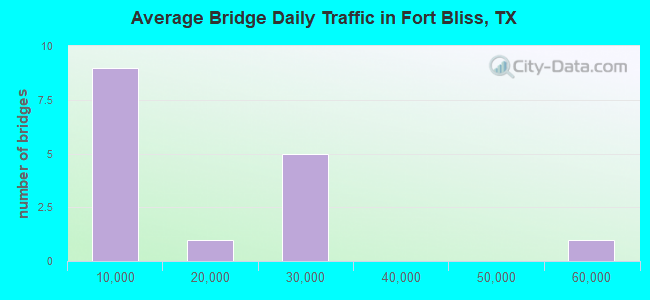
- 214,742Total average daily traffic
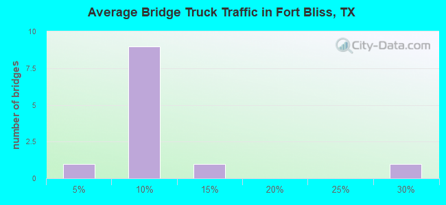
- 16,458Total average daily truck traffic
- National Bridge Inventory (NBI) Registered Bridges for Fort Bliss
- No street view available for this location
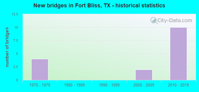
- New bridges - historical statistics
- 41970-1979
- 22000-2009
- 102010-2019
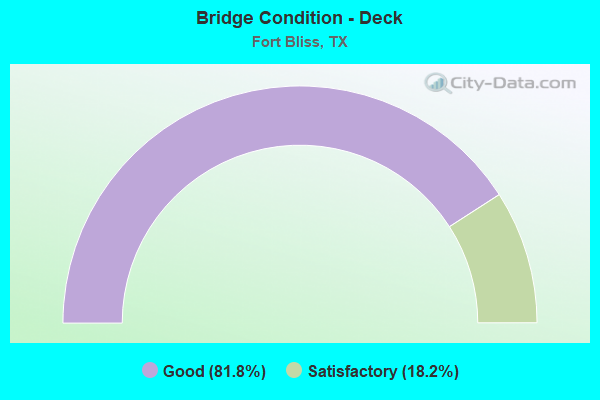
- Bridge Condition - Deck
- 81.8%Good
- 18.2%Satisfactory
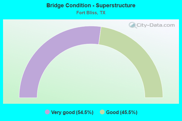
- Bridge Condition - Superstructure
- 54.5%Very good
- 45.5%Good
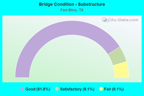
- Bridge Condition - Substructure
- 81.8%Good
- 9.1%Satisfactory
- 9.1%Fair
Find on map >> Show street view
Structure Number: 240720016701049, Location: 0.5 MI N VAN BUREN AVE (Lat: 31.820786, Lng: -106.437731), Route carried "on" structure: City street , Year Built: 1976, Status: Open, Structure Length: 30.75m (100.89ft), Average Daily Traffic: 25,220 (year 2009), Truck Traffic: 9%, Average Future Daily Traffic: 35,300 (year 2029), Design Load: HS 20, Features Intersected: US 54 EB FR & UP RR, Facility Carried by Structure: SHERIDAN RD NB
Minimum Vertical Clearance: 30+ m (98+ ft), Kilometerpoint: 14.629, Lanes on structure: 2, Lanes under structure: 3, Owner: State Highway Agency, Approaching Roadway Width: 9.1m (29.9ft), Skew: 9 degrees, Material/Design: Steel continuous, Design/Construction: Stringer/Multi-beam, Number Of Spans In Main Unit: 3, Number Of Approach Spans: 8, Length of Maximum Span: 48.8m (160.1ft), Curb-To-Curb Width: 9.1m (29.9ft), Out-to-Out Width: 9.7m (31.8ft)
Condition: Deck: Satisfactory, Superstructure: Good, Substructure: Satisfactory, Operating Rating: 54.4 metric tons, Method Used To Determine Operating Rating: Assigned rating based on Load Factor Design (LFD) reported in metric tons, Inventory Rating: 32.7 metric tons, Method Used To Determine Inventory Rating: Assigned rating based on Load Factor Design (LFD) reported in metric tons, Structural Evaluation: Equal to present minimum criteria, Deck Geometry: Meets minimum limits, Underclear: Somewhat better than minimum adequacy, Approach Roadway Alignment: Equal to present desirable criteria, Designated Inspection Frequency: Every 24 months, Critical Feature Inspection Frequency: Every 24 months, Inspection Date: May 2021, Critical Feature Inspection Date: Febuary 2021, Deck Structure Type: Concrete Cast-file-Place
Find on map >> Show street view
Structure Number: 240720016701056, Location: 0.5 MI N VAN BUREN AVE (Lat: 31.820786, Lng: -106.437831), Route carried "on" structure: City street , Year Built: 1976, Status: Open, Structure Length: 31.67m (103.90ft), Average Daily Traffic: 25,220 (year 2009), Truck Traffic: 9%, Average Future Daily Traffic: 35,300 (year 2029), Design Load: HS 20, Features Intersected: US 54 & UP RR, Facility Carried by Structure: SHERIDAN RD SB
Minimum Vertical Clearance: 5.13m (16.83ft), Kilometerpoint: 14.627, Lanes on structure: 2, Lanes under structure: 9, Base Highway Network: Yes, Owner: State Highway Agency, Approaching Roadway Width: 9.1m (29.9ft), Skew: 9 degrees, Material/Design: Steel continuous, Design/Construction: Stringer/Multi-beam, Number Of Spans In Main Unit: 4, Number Of Approach Spans: 5, Length of Maximum Span: 62.5m (205.1ft), Curb or Sidewalk Widths: Left: 1.3m (4.3ft), Right: 0.0m, Curb-To-Curb Width: 9.1m (29.9ft), Out-to-Out Width: 11.2m (36.7ft)
Condition: Deck: Satisfactory, Superstructure: Good, Substructure: Fair, Operating Rating: 68.0 metric tons, Method Used To Determine Operating Rating: Load Factor (LF), Inventory Rating: 40.8 metric tons, Method Used To Determine Inventory Rating: Load Factor (LF), Structural Evaluation: Somewhat better than minimum adequacy, Deck Geometry: Meets minimum limits, Underclear: Somewhat better than minimum adequacy, Approach Roadway Alignment: Equal to present desirable criteria, Length Of Structure Improvement: 31.67m (103.90ft), Designated Inspection Frequency: Every 24 months, Inspection Date: May 2021, Bridge Improvement Cost: $62,000, Roadway Improvement Cost: $16,000, Total Project Cost: $78,000, Deck Structure Type: Concrete Cast-file-Place
Find on map >> Show street view
Structure Number: 240720104603111, Location: 1.90 MI E OF US 54 (Lat: 31.825617, Lng: -106.405997), Route carried "on" structure: State highway 601, Year Built: 2011, Status: Open, Structure Length: 19.96m (65.49ft), Average Daily Traffic: 50 (year 2014), Average Future Daily Traffic: 100 (year 2034), Design Load: HS 25 or greater, Features Intersected: RAMPS B D E AIRPORT DR
Minimum Vertical Clearance: 30+ m (98+ ft), Kilometerpoint: 3.058, Lanes on structure: 3, Lanes under structure: 6, Owner: State Highway Agency, Approaching Roadway Width: 17.1m (56.1ft), Material/Design: Steel, Design/Construction: Stringer/Multi-beam, Number Of Spans In Main Unit: 1, Number Of Approach Spans: 5, Length of Maximum Span: 45.7m (149.9ft), Curb-To-Curb Width: 17.1m (56.1ft), Out-to-Out Width: 17.7m (58.1ft)
Condition: Deck: Good, Superstructure: Very good, Substructure: Good, Operating Rating: 68.0 metric tons, Method Used To Determine Operating Rating: Assigned ratings based on Load and Resistance Factor Design (LRFD) reported in metric tons, Inventory Rating: 40.8 metric tons, Method Used To Determine Inventory Rating: Assigned ratings based on Load and Resistance Factor Design (LRFD) reported in metric tons, Structural Evaluation: Better than present minimum criteria, Deck Geometry: Equal to present minimum criteria, Underclear: Meets minimum limits, Approach Roadway Alignment: Equal to present desirable criteria, Designated Inspection Frequency: Every 24 months, Inspection Date: March 2020, Deck Structure Type: Concrete Cast-file-Place
Find on map >> Show street view
Structure Number: 24072010460312, Location: 2.6 MI W OF LOOP 375 SB (Lat: 31.830000, Lng: -106.364669), Route carried "on" structure: State highway 601, Year Built: 2010, Status: Open, Structure Length: 6.25m (20.51ft), Average Daily Traffic: 13,600 (year 2010), Truck Traffic: 5%, Average Future Daily Traffic: 14,700 (year 2030), Design Load: HL 93, Features Intersected: GLOBAL REACH DR
Minimum Vertical Clearance: 30+ m (98+ ft), Kilometerpoint: 7.580, Lanes on structure: 4, Lanes under structure: 8, Owner: State Highway Agency, Approaching Roadway Width: 34.1m (111.9ft), Skew: 30 degrees, Material/Design: Prestressed concrete, Design/Construction: Stringer/Multi-beam, Number Of Spans In Main Unit: 1, Number Of Approach Spans: 2, Length of Maximum Span: 27.7m (90.9ft), Curb-To-Curb Width: 34.1m (111.9ft), Out-to-Out Width: 36.0m (118.1ft)
Condition: Deck: Good, Superstructure: Very good, Substructure: Good, Operating Rating: 54.4 metric tons, Method Used To Determine Operating Rating: Assigned ratings based on Load and Resistance Factor Design (LRFD) reported in metric tons, Inventory Rating: 32.7 metric tons, Method Used To Determine Inventory Rating: Assigned ratings based on Load and Resistance Factor Design (LRFD) reported in metric tons, Structural Evaluation: Better than present minimum criteria, Deck Geometry: Superior to present desirable criteria, Underclear: Meets minimum limits, Approach Roadway Alignment: Equal to present desirable criteria, Designated Inspection Frequency: Every 24 months, Inspection Date: March 2020, Deck Structure Type: Concrete Precast Panels
Find on map >> Show street view
Structure Number: 240720104603122, Location: 2.5 MI E OF US 54 NB (Lat: 31.820308, Lng: -106.398492), Route carried "on" structure: State highway 601, Year Built: 2010, Status: Open, Structure Length: 3.44m (11.29ft), Average Daily Traffic: 20,200 (year 2010), Truck Traffic: 5%, Average Future Daily Traffic: 25,200 (year 2030), Design Load: HL 93, Features Intersected: POV-A RD (HANN RD)
Minimum Vertical Clearance: 30+ m (98+ ft), Kilometerpoint: 3.991, Lanes on structure: 5, Lanes under structure: 4, Owner: State Highway Agency, Approaching Roadway Width: 34.1m (111.9ft), Skew: 34 degrees, Material/Design: Prestressed concrete, Design/Construction: Stringer/Multi-beam, Number Of Spans In Main Unit: 1, Length of Maximum Span: 34.4m (112.9ft), Curb-To-Curb Width: 34.1m (111.9ft), Out-to-Out Width: 36.0m (118.1ft)
Condition: Deck: Good, Superstructure: Very good, Substructure: Good, Operating Rating: 54.4 metric tons, Method Used To Determine Operating Rating: Assigned ratings based on Load and Resistance Factor Design (LRFD) reported in metric tons, Inventory Rating: 32.7 metric tons, Method Used To Determine Inventory Rating: Assigned ratings based on Load and Resistance Factor Design (LRFD) reported in metric tons, Structural Evaluation: Better than present minimum criteria, Deck Geometry: Superior to present desirable criteria, Underclear: High priority of corrective action, Approach Roadway Alignment: Equal to present desirable criteria, Designated Inspection Frequency: Every 24 months, Inspection Date: March 2020, Deck Structure Type: Concrete Precast Panels
Find on map >> Show street view
Structure Number: 240720104603123, Location: 0.55 MI E OF US 54 (Lat: 31.825811, Lng: -106.428758), Route carried "on" structure: Ramp State highway 601, Year Built: 2010, Status: Open, Structure Length: 9.33m (30.61ft), Average Daily Traffic: 7,500 (year 2010), Truck Traffic: 5%, Average Future Daily Traffic: 9,100 (year 2030), Design Load: HL 93, Features Intersected: VACANT TXDOT ROW
Minimum Vertical Clearance: 30+ m (98+ ft), Kilometerpoint: 0.885, Lanes on structure: 1, Owner: State Highway Agency, Approaching Roadway Width: 7.3m (24.0ft), Material/Design: Prestressed concrete, Design/Construction: Stringer/Multi-beam, Number Of Spans In Main Unit: 3, Length of Maximum Span: 32.3m (106.0ft), Curb-To-Curb Width: 7.3m (24.0ft), Out-to-Out Width: 7.9m (25.9ft)
Condition: Deck: Good, Superstructure: Very good, Substructure: Good, Operating Rating: 54.4 metric tons, Method Used To Determine Operating Rating: Assigned ratings based on Load and Resistance Factor Design (LRFD) reported in metric tons, Inventory Rating: 32.7 metric tons, Method Used To Determine Inventory Rating: Assigned ratings based on Load and Resistance Factor Design (LRFD) reported in metric tons, Structural Evaluation: Better than present minimum criteria, Deck Geometry: Better than present minimum criteria, Approach Roadway Alignment: Equal to present desirable criteria, Designated Inspection Frequency: Every 24 months, Inspection Date: March 2020, Deck Structure Type: Concrete Precast Panels
Find on map >> Show street view
Structure Number: 240720104603125, Location: 1.05 MI EAST OF US 54 NB (Lat: 31.826147, Lng: -106.420700), Route carried "on" structure: Ramp State highway 601, Year Built: 2010, Status: Open, Structure Length: 6.74m (22.11ft), Average Daily Traffic: 5,800 (year 2010), Truck Traffic: 5%, Average Future Daily Traffic: 9,600 (year 2030), Design Load: HL 93, Features Intersected: TxDOT ROW
Minimum Vertical Clearance: 30+ m (98+ ft), Kilometerpoint: 0.000, Lanes on structure: 1, Owner: State Highway Agency, Approaching Roadway Width: 7.3m (24.0ft), Material/Design: Prestressed concrete, Design/Construction: Stringer/Multi-beam, Number Of Spans In Main Unit: 2, Length of Maximum Span: 33.8m (110.9ft), Curb-To-Curb Width: 7.3m (24.0ft), Out-to-Out Width: 7.9m (25.9ft)
Condition: Deck: Good, Superstructure: Very good, Substructure: Good, Operating Rating: 54.4 metric tons, Method Used To Determine Operating Rating: Assigned ratings based on Load and Resistance Factor Design (LRFD) reported in metric tons, Inventory Rating: 32.7 metric tons, Method Used To Determine Inventory Rating: Assigned ratings based on Load and Resistance Factor Design (LRFD) reported in metric tons, Structural Evaluation: Better than present minimum criteria, Deck Geometry: Better than present minimum criteria, Approach Roadway Alignment: Equal to present desirable criteria, Designated Inspection Frequency: Every 24 months, Inspection Date: March 2020, Deck Structure Type: Concrete Precast Panels
Find on map >> Show street view
Structure Number: DAPTRABLI000011, Location: E/O CHAFFEE ROAD (Lat: 31.826350, Lng: -106.413100), Route carried "on" structure: Other road , Year Built: 2001, Status: Open, Structure Length: 15.60m (51.18ft), Average Daily Traffic: 300 (year 2020), Truck Traffic: 25%, Average Future Daily Traffic: 500 (year 2042), Design Load: HS 25 or greater, Features Intersected: FRED WILSON RD. & RR, Facility Carried by Structure: CARRINGTON RD
Minimum Vertical Clearance: 30+ m (98+ ft), Kilometerpoint: 0.000, Lanes on structure: 2, Lanes under structure: 6, Owner: Army, Approaching Roadway Width: 7.5m (24.6ft), Material/Design: Steel continuous, Design/Construction: Stringer/Multi-beam, Number Of Spans In Main Unit: 4, Length of Maximum Span: 42.0m (137.8ft), Curb-To-Curb Width: 7.5m (24.6ft), Out-to-Out Width: 9.6m (31.5ft)
Condition: Deck: Good, Superstructure: Very good, Substructure: Good, Structural Evaluation: Better than present minimum criteria, Deck Geometry: Somewhat better than minimum adequacy, Underclear: Equal to present minimum criteria, Approach Roadway Alignment: Equal to present minimum criteria, Length Of Structure Improvement: 16.36m (53.67ft), Designated Inspection Frequency: Every 24 months, Inspection Date: August 2020, Bridge Improvement Cost: $1,000, Roadway Improvement Cost: $1,000, Total Project Cost: $2,000 ( Estimate for 2020), Deck Structure Type: Concrete Cast-file-Place
Find on map >> Show street view
Structure Number: DAPTRABLI000012, Location: N/O FOUNDERS BLV. (Lat: 31.819881, Lng: -106.404600), Route carried "on" structure: Other road , Year Built: 2008, Status: Open, Structure Length: 3.96m (12.99ft), Average Daily Traffic: 1 (year 2020), Average Future Daily Traffic: 4 (year 2042), Design Load: HS 25 or greater, Features Intersected: AIRPORT RD, Facility Carried by Structure: HAAN RD
Minimum Vertical Clearance: 30+ m (98+ ft), Kilometerpoint: 0.000, Lanes on structure: 4, Lanes under structure: 6, Owner: Army, Approaching Roadway Width: 17.1m (56.1ft), Material/Design: Prestressed concrete, Design/Construction: Stringer/Multi-beam, Number Of Spans In Main Unit: 2, Length of Maximum Span: 19.4m (63.6ft), Curb or Sidewalk Widths: Left: 1.9m (6.2ft), Right: 0.0m, Curb-To-Curb Width: 17.1m (56.1ft), Out-to-Out Width: 20.2m (66.3ft)
Condition: Deck: Good, Superstructure: Good, Substructure: Good, Operating Rating: 97.2 metric tons, Method Used To Determine Operating Rating: Load and Resistance Factor Rating (LRFR) rating reported by rating factor(RF) method using HL-93 loadings, Inventory Rating: 97.2 metric tons, Method Used To Determine Inventory Rating: Load and Resistance Factor Rating (LRFR) rating reported by rating factor(RF) method using HL-93 loadings, Structural Evaluation: Better than present minimum criteria, Deck Geometry: Somewhat better than minimum adequacy, Underclear: Meets minimum limits, Approach Roadway Alignment: Equal to present minimum criteria, Length Of Structure Improvement: 4.91m (16.11ft), Designated Inspection Frequency: Every 24 months, Inspection Date: August 2020, Bridge Improvement Cost: $1,000, Roadway Improvement Cost: $1,000, Total Project Cost: $2,000 ( Estimate for 2020), Deck Structure Type: Concrete Cast-file-Place, Wearing Surface/Protective System: Wearing Surface: Monolithic Concrete
Find on map >> Show street view
Structure Number: DAPTRABLI000014, Location: NE OF BIGGS FIELD (Lat: 31.866381, Lng: -106.339800), Route carried "on" structure: Other road , Year Built: 2010, Status: Open, Structure Length: 17.98m (58.99ft), Average Daily Traffic: 1 (year 2020), Average Future Daily Traffic: 2 (year 2042), Design Load: HS 25 or greater, Features Intersected: LOOP 375, Facility Carried by Structure: TORCH ST
Minimum Vertical Clearance: 30+ m (98+ ft), Kilometerpoint: 0.000, Lanes on structure: 4, Lanes under structure: 6, Owner: Army, Approaching Roadway Width: 14.7m (48.2ft), Material/Design: Prestressed concrete, Design/Construction: Stringer/Multi-beam, Number Of Spans In Main Unit: 7, Length of Maximum Span: 33.0m (108.3ft), Curb or Sidewalk Widths: Left: 3.7m (12.1ft), Right: 0.0m, Curb-To-Curb Width: 14.7m (48.2ft), Out-to-Out Width: 19.5m (64.0ft)
Condition: Deck: Good, Superstructure: Good, Substructure: Good, Operating Rating: 55.7 metric tons, Method Used To Determine Operating Rating: Load and Resistance Factor Rating (LRFR) rating reported by rating factor(RF) method using HL-93 loadings, Inventory Rating: 43.1 metric tons, Method Used To Determine Inventory Rating: Load and Resistance Factor Rating (LRFR) rating reported by rating factor(RF) method using HL-93 loadings, Structural Evaluation: Better than present minimum criteria, Deck Geometry: High priority of replacement, Approach Roadway Alignment: Equal to present minimum criteria, Length Of Structure Improvement: 18.66m (61.22ft), Designated Inspection Frequency: Every 24 months, Inspection Date: August 2020, Bridge Improvement Cost: $1,000, Roadway Improvement Cost: $1,000, Total Project Cost: $2,000 ( Estimate for 2020), Deck Structure Type: Concrete Cast-file-Place, Wearing Surface/Protective System: Wearing Surface: Monolithic Concrete
Find on map >> Show street view
Structure Number: DAPTRABLI01856, Location: IRON MEDICS OVERPASS (Lat: 31.831469, Lng: -106.309700), Route carried "on" structure: Other road , Year Built: 2013, Status: Open, Structure Length: 17.98m (58.99ft), Average Daily Traffic: 200 (year 2020), Average Future Daily Traffic: 500 (year 2042), Design Load: HS 25 or greater, Features Intersected: LOOP 375, Facility Carried by Structure: IRON MEDICS DR
Minimum Vertical Clearance: 30+ m (98+ ft), Kilometerpoint: 0.000, Lanes on structure: 2, Lanes under structure: 4, Owner: Army, Approaching Roadway Width: 15.9m (52.2ft), Skew: 20 degrees, Material/Design: Prestressed concrete, Design/Construction: Stringer/Multi-beam, Number Of Spans In Main Unit: 6, Length of Maximum Span: 35.1m (115.2ft), Curb or Sidewalk Widths: Left: 1.8m (5.9ft), Right: 0.0m, Curb-To-Curb Width: 15.9m (52.2ft), Out-to-Out Width: 19.7m (64.6ft)
Condition: Deck: Good, Superstructure: Good, Substructure: Good, Operating Rating: 50.2 metric tons, Method Used To Determine Operating Rating: Load and Resistance Factor Rating (LRFR) rating reported by rating factor(RF) method using HL-93 loadings, Inventory Rating: 38.9 metric tons, Method Used To Determine Inventory Rating: Load and Resistance Factor Rating (LRFR) rating reported by rating factor(RF) method using HL-93 loadings, Structural Evaluation: Better than present minimum criteria, Deck Geometry: Superior to present desirable criteria, Underclear: Equal to present minimum criteria, Approach Roadway Alignment: Equal to present minimum criteria, Length Of Structure Improvement: 18.66m (61.22ft), Designated Inspection Frequency: Every 24 months, Inspection Date: August 2020, Bridge Improvement Cost: $1,000, Roadway Improvement Cost: $1,000, Total Project Cost: $2,000 ( Estimate for 2020), Deck Structure Type: Concrete Cast-file-Place
Find on map >> Show street view
Structure Number: 240720016701049, Location: 0.5 MI N VAN BUREN AVE (Lat: 31.820786, Lng: -106.437731), Route carried "under" structure: US 54, Year Built: 1976, Structure Length: 0. m, Average Daily Traffic: 25,220 (year 2009), Truck Traffic: 9%, Features Intersected: US 54 EB FR & UP RR, Facility Carried by Structure: SHERIDAN RD NB
Minimum Vertical Clearance: 5.18m (16.99ft), Kilometerpoint: 14.629, Lanes on structure: 2, Lanes under structure: 3, Material/Design: Steel continuous, Design/Construction: Stringer/Multi-beam, Length of Maximum Span: 48.8m (160.1ft)
Find on map >> Show street view
Structure Number: 240720016701056, Location: 0.5 MI N VAN BUREN AVE (Lat: 31.820786, Lng: -106.437831), Route carried "under" structure: US 54, Year Built: 1976, Structure Length: 0. m, Average Daily Traffic: 58,030 (year 2013), Truck Traffic: 10%, Features Intersected: US 54 & UP RR, Facility Carried by Structure: SHERIDAN RD SB
Minimum Vertical Clearance: 5.21m (17.09ft), Kilometerpoint: 14.629, Lanes on structure: 2, Lanes under structure: 9, Material/Design: Steel continuous, Design/Construction: Stringer/Multi-beam, Length of Maximum Span: 62.5m (205.1ft)
Find on map >> Show street view
Structure Number: 240720104603111, Location: 1.90 MI E OF US 54 (Lat: 31.824939, Lng: -106.404719), Route carried "under" structure: City street , Year Built: 2011, Structure Length: 0. m, Average Daily Traffic: 2,000 (year 2018), Truck Traffic: 5%, Features Intersected: AIRPORT DR NB, Facility Carried by Structure: SPUR 601 EB
Minimum Vertical Clearance: 5.54m (18.18ft), Kilometerpoint: 1.609, Lanes on structure: 3, Lanes under structure: 2, Material/Design: Steel, Design/Construction: Stringer/Multi-beam, Length of Maximum Span: 45.7m (149.9ft)
Find on map >> Show street view
Structure Number: 24072010460312, Location: 2.6 MI W OF LOOP 375 SB (Lat: 31.830189, Lng: -106.364419), Route carried "under" structure: State highway , Year Built: 2010, Structure Length: 0. m, Average Daily Traffic: 25,100 (year 2010), Truck Traffic: 5%, Features Intersected: GLOBAL REACH DR, Facility Carried by Structure: SPUR 601
Minimum Vertical Clearance: 5.18m (16.99ft), Kilometerpoint: 0.161, Lanes on structure: 4, Lanes under structure: 6, Material/Design: Prestressed concrete, Design/Construction: Stringer/Multi-beam, Length of Maximum Span: 27.7m (90.9ft)
Find on map >> Show street view
Structure Number: 240720104603122, Location: 2.5 MI E OF US 54 NB (Lat: 31.820289, Lng: -106.398319), Route carried "under" structure: County highway , Year Built: 2010, Structure Length: 0. m, Average Daily Traffic: 6,300 (year 2018), Truck Traffic: 1%, Features Intersected: HAAN RD, Facility Carried by Structure: SPUR 601
Minimum Vertical Clearance: 7.32m (24.02ft), Kilometerpoint: 3.766, Lanes on structure: 5, Lanes under structure: 4, Material/Design: Prestressed concrete, Design/Construction: Stringer/Multi-beam, Length of Maximum Span: 34.4m (112.9ft)