Bridge Statistics for Fort Edward, New York (NY)
Condition, Traffic, Stress, Structural Evaluation, Project Costs
- National Bridge Inventory (NBI) Statistics
- 12Number of bridges
- 161ft / 48.8mTotal length
- $28,262,000Total costs
- 41,049Total average daily traffic
- 2,644Total average daily truck traffic
- National Bridge Inventory (NBI) Registered Bridges for Fort Edward
- No street view available for this location
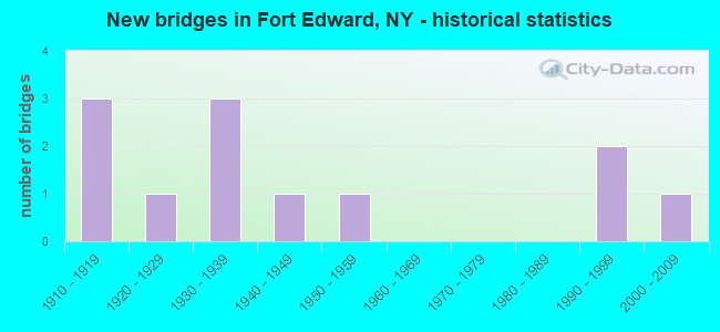
- New bridges - historical statistics
- 31910-1919
- 11920-1929
- 31930-1939
- 11940-1949
- 11950-1959
- 21990-1999
- 12000-2009

- Reconstructed bridges - Historical Statistics
- 21980-1989
- 21990-1999
- 12000-2009


- Bridge Condition - Deck
- 11.1%Very good
- 44.4%Good
- 22.2%Satisfactory
- 22.2%Fair

- Bridge Condition - Superstructure
- 20.0%Very good
- 30.0%Good
- 20.0%Satisfactory
- 20.0%Fair
- 10.0%Poor

- Bridge Condition - Substructure
- 20.0%Very good
- 10.0%Good
- 20.0%Satisfactory
- 30.0%Fair
- 20.0%Poor

- Bridge Condition - Channel
- 11.1%Very good
- 44.4%Good
- 33.3%Satisfactory
- 11.1%Fair
Find on map >> Show street view
Structure Number: 100103, Location: 5.4 MI N JCT US 4 & SH 32 (Lat: 43.199078, Lng: -73.581181), Route carried "on" structure: US 4, Year Built: 1957, Status: Open, Structure Length: 4.54m (14.90ft), Average Daily Traffic: 3,788 (year 2020), Truck Traffic: 6%, Average Future Daily Traffic: 4,039 (year 2040), Design Load: H 20, Features Intersected: MOSES KILL
Minimum Vertical Clearance: 30+ m (98+ ft), Kilometerpoint: 8.109, Lanes on structure: 2, Base Highway Network: Yes, Owner: State Highway Agency, Approaching Roadway Width: 12.2m (40.0ft), Skew: 2 degrees, Material/Design: Steel, Design/Construction: Stringer/Multi-beam, Number Of Spans In Main Unit: 1, Length of Maximum Span: 43.8m (143.7ft), Curb or Sidewalk Widths: Left: 0.9m (3.0ft), Right: 0.9m (3.0ft), Curb-To-Curb Width: 10.4m (34.1ft), Out-to-Out Width: 12.6m (41.3ft)
Condition: Deck: Fair, Superstructure: Good, Substructure: Satisfactory, Channel: Good, Operating Rating: 65.3 metric tons, Method Used To Determine Operating Rating: Load Factor (LF), Inventory Rating: 39.0 metric tons, Method Used To Determine Inventory Rating: Load Factor (LF), Structural Evaluation: Equal to present minimum criteria, Deck Geometry: Somewhat better than minimum adequacy, Waterway Adequacy: Superior to present desirable criteria, Approach Roadway Alignment: Equal to present desirable criteria, Length Of Structure Improvement: 4.54m (14.90ft), Designated Inspection Frequency: Every 24 months, Inspection Date: June 2020, Bridge Improvement Cost: $1,347,000, Roadway Improvement Cost: $789,000, Total Project Cost: $2,136,000 ( Estimate for 2021), Deck Structure Type: Concrete Cast-file-Place, Wearing Surface/Protective System: Wearing Surface: Monolithic Concrete
Find on map >> Show street view
Structure Number: 100107, Location: JCT US 4 & DEL & HUD RR (Lat: 43.272478, Lng: -73.587328), Route carried "on" structure: US 4, Year Built: 2003, Status: Open, Structure Length: 1.22m (4.00ft), Average Daily Traffic: 11,486 (year 2020), Truck Traffic: 7%, Average Future Daily Traffic: 11,539 (year 2040), Design Load: HS 25 or greater, Features Intersected: D&H RR
Minimum Vertical Clearance: 30+ m (98+ ft), Kilometerpoint: 17.281, Lanes on structure: 2, Base Highway Network: Yes, Owner: State Highway Agency, Approaching Roadway Width: 11.6m (38.1ft), Material/Design: Concrete, Design/Construction: Box Beam or Girders - Multiple, Number Of Spans In Main Unit: 1, Length of Maximum Span: 11.0m (36.1ft), Curb or Sidewalk Widths: Left: 1.5m (4.9ft), Right: 1.7m (5.6ft), Curb-To-Curb Width: 11.6m (38.1ft), Out-to-Out Width: 15.8m (51.8ft)
Condition: Deck: Good, Superstructure: Good, Substructure: Very good, Operating Rating: 88.9 metric tons, Method Used To Determine Operating Rating: Load Factor (LF), Inventory Rating: 43.5 metric tons, Method Used To Determine Inventory Rating: Load Factor (LF), Structural Evaluation: Better than present minimum criteria, Deck Geometry: Somewhat better than minimum adequacy, Underclear: High priority of corrective action, Approach Roadway Alignment: Somewhat better than minimum adequacy, Length Of Structure Improvement: 1.21m (3.97ft), Designated Inspection Frequency: Every 24 months, Inspection Date: April 2021, Bridge Improvement Cost: $750,000, Roadway Improvement Cost: $439,000, Total Project Cost: $1,189,000 ( Estimate for 2021), Deck Structure Type: Concrete Cast-file-Place, Wearing Surface/Protective System: Wearing Surface: Integral Concrete, Deck Protection: Epoxy Coated Reinforcing
Find on map >> Show street view
Structure Number: 330574, Location: 4.5 MI S OF FORT EDWARD (Lat: 43.205397, Lng: -73.551156), Route carried "on" structure: County highway , Year Built: 1928, Year Reconstructed: 1992, Status: Open, Structure Length: 1.62m (5.31ft), Average Daily Traffic: 357 (year 2020), Truck Traffic: 6%, Average Future Daily Traffic: 500 (year 2040), Design Load: HS 20, Features Intersected: MOSES KILL, Facility Carried by Structure: PATTERSON ROAD
Minimum Vertical Clearance: 30+ m (98+ ft), Kilometerpoint: 5.117, Lanes on structure: 2, Owner: County Highway Agency, Approaching Roadway Width: 7.6m (24.9ft), Material/Design: Steel, Design/Construction: Stringer/Multi-beam, Number Of Spans In Main Unit: 1, Length of Maximum Span: 15.5m (50.9ft), Curb-To-Curb Width: 8.4m (27.6ft), Out-to-Out Width: 8.6m (28.2ft)
Condition: Deck: Good, Superstructure: Satisfactory, Substructure: Fair, Channel: Satisfactory, Operating Rating: 87.1 metric tons, Method Used To Determine Operating Rating: Load Factor (LF), Inventory Rating: 51.7 metric tons, Method Used To Determine Inventory Rating: Load Factor (LF), Structural Evaluation: Somewhat better than minimum adequacy, Deck Geometry: Somewhat better than minimum adequacy, Waterway Adequacy: Meets minimum limits, Approach Roadway Alignment: Equal to present minimum criteria, Length Of Structure Improvement: 1.61m (5.28ft), Designated Inspection Frequency: Every 24 months, Inspection Date: May 2021, Bridge Improvement Cost: $423,000, Roadway Improvement Cost: $248,000, Total Project Cost: $671,000 ( Estimate for 2021), Deck Structure Type: Wood or Timber, Wearing Surface/Protective System: Wearing Surface: Bituminous, Membrane: Other
Find on map >> Show street view
Structure Number: 330611, Location: 3.2 MI S JCT RTS 197 + 4 (Lat: 43.216928, Lng: -73.558617), Route carried "on" structure: Other road , Year Built: 1931, Year Reconstructed: 2001, Status: Open, Structure Length: 1.71m (5.61ft), Average Daily Traffic: 39 (year 2017), Truck Traffic: 6%, Average Future Daily Traffic: 55 (year 2037), Design Load: H 20, Features Intersected: MOSES KILL, Facility Carried by Structure: WOODARD ROAD
Minimum Vertical Clearance: 30+ m (98+ ft), Kilometerpoint: 1.577, Lanes on structure: 2, Owner: County Highway Agency, Approaching Roadway Width: 7.3m (24.0ft), Skew: 2 degrees, Material/Design: Steel, Design/Construction: Stringer/Multi-beam, Number Of Spans In Main Unit: 1, Length of Maximum Span: 16.5m (54.1ft), Curb-To-Curb Width: 7.3m (24.0ft), Out-to-Out Width: 7.9m (25.9ft)
Condition: Deck: Very good, Superstructure: Very good, Substructure: Satisfactory, Channel: Fair, Inventory Rating: 82.6 metric tons, Method Used To Determine Inventory Rating: Load Factor (LF), Structural Evaluation: Equal to present minimum criteria, Deck Geometry: Equal to present minimum criteria, Waterway Adequacy: Superior to present desirable criteria, Approach Roadway Alignment: Meets minimum limits, Length Of Structure Improvement: 1.70m (5.58ft), Designated Inspection Frequency: Every 24 months, Inspection Date: June 2021, Bridge Improvement Cost: $423,000, Roadway Improvement Cost: $248,000, Total Project Cost: $671,000 ( Estimate for 2021), Deck Structure Type: Concrete Cast-file-Place, Wearing Surface/Protective System: Wearing Surface: Integral Concrete
Find on map >> Show street view
Structure Number: 330613, Location: 3.2 MI S JCT US 4 & SH197 (Lat: 43.217247, Lng: -73.570608), Route carried "on" structure: County highway , Year Built: 1934, Year Reconstructed: 1995, Status: Open, Structure Length: 0.98m (3.22ft), Average Daily Traffic: 111 (year 2017), Truck Traffic: 6%, Average Future Daily Traffic: 155 (year 2037), Design Load: H 20, Features Intersected: DEAD CREEK, Facility Carried by Structure: CAREY ROAD
Minimum Vertical Clearance: 30+ m (98+ ft), Kilometerpoint: 0.644, Lanes on structure: 2, Owner: County Highway Agency, Approaching Roadway Width: 7.3m (24.0ft), Material/Design: Steel, Design/Construction: Stringer/Multi-beam, Number Of Spans In Main Unit: 1, Length of Maximum Span: 9.4m (30.8ft), Curb-To-Curb Width: 7.9m (25.9ft), Out-to-Out Width: 8.5m (27.9ft)
Condition: Deck: Satisfactory, Superstructure: Satisfactory, Substructure: Fair, Channel: Satisfactory, Operating Rating: 67.1 metric tons, Method Used To Determine Operating Rating: Load and Resistance Factor Rating (LRFR) rating reported by rating factor(RF) method using HL-93 loadings, Inventory Rating: 51.5 metric tons, Method Used To Determine Inventory Rating: Load and Resistance Factor Rating (LRFR) rating reported by rating factor(RF) method using HL-93 loadings, Structural Evaluation: Somewhat better than minimum adequacy, Deck Geometry: Somewhat better than minimum adequacy, Waterway Adequacy: Somewhat better than minimum adequacy, Approach Roadway Alignment: Equal to present desirable criteria, Length Of Structure Improvement: 0.97m (3.18ft), Designated Inspection Frequency: Every 24 months, Inspection Date: July 2020, Bridge Improvement Cost: $457,000, Roadway Improvement Cost: $268,000, Total Project Cost: $724,000 ( Estimate for 2021), Deck Structure Type: Wood or Timber, Wearing Surface/Protective System: Wearing Surface: Bituminous, Membrane: Other
Find on map >> Show street view
Structure Number: 330623, Location: 1 MI EAST OF FORT EDWARD (Lat: 43.247444, Lng: -73.539033), Route carried "on" structure: County highway , Year Built: 1938, Year Reconstructed: 1989, Status: Open, Structure Length: 0.76m (2.49ft), Average Daily Traffic: 554 (year 2019), Truck Traffic: 8%, Average Future Daily Traffic: 776 (year 2039), Features Intersected: DEAD CREEK, Facility Carried by Structure: DURKEETOWN ROAD
Minimum Vertical Clearance: 30+ m (98+ ft), Kilometerpoint: 12.068, Lanes on structure: 2, Owner: County Highway Agency, Approaching Roadway Width: 6.1m (20.0ft), Material/Design: Steel, Design/Construction: Stringer/Multi-beam, Number Of Spans In Main Unit: 1, Length of Maximum Span: 7.0m (23.0ft), Curb-To-Curb Width: 7.7m (25.3ft), Out-to-Out Width: 8.6m (28.2ft)
Condition: Deck: Good, Superstructure: Fair, Substructure: Poor, Channel: Satisfactory, Operating Rating: 88.9 metric tons, Method Used To Determine Operating Rating: Load Factor (LF), Inventory Rating: 53.5 metric tons, Method Used To Determine Inventory Rating: Load Factor (LF), Structural Evaluation: Meets minimum limits, Deck Geometry: Meets minimum limits, Waterway Adequacy: Somewhat better than minimum adequacy, Approach Roadway Alignment: Meets minimum limits, Length Of Structure Improvement: 0.76m (2.49ft), Designated Inspection Frequency: Every 24 months, Inspection Date: July 2020, Bridge Improvement Cost: $185,000, Roadway Improvement Cost: $108,000, Total Project Cost: $293,000 ( Estimate for 2021), Deck Structure Type: Wood or Timber, Wearing Surface/Protective System: Wearing Surface: Bituminous, Membrane: Other
Find on map >> Show street view
Structure Number: 400104, Location: JCT RTE 4 & CHAMP CANAL (Lat: 43.259811, Lng: -73.580803), Route carried "on" structure: US 4, Year Built: 1990, Status: Open, Structure Length: 10.06m (33.01ft), Average Daily Traffic: 3,788 (year 2020), Truck Traffic: 6%, Average Future Daily Traffic: 4,601 (year 2040), Design Load: HS 20, Features Intersected: CHAMPLAIN CANAL
Minimum Vertical Clearance: 30+ m (98+ ft), Kilometerpoint: 15.430, Lanes on structure: 2, Base Highway Network: Yes, Owner: State Highway Agency, Approaching Roadway Width: 11.6m (38.1ft), Skew: 4 degrees, Navigation Control: Yes ( Vertical Clearance: 4.5m (14.8ft), Horizontal Clearance: 22.8m (74.8ft)), Material/Design: Steel continuous, Design/Construction: Stringer/Multi-beam, Number Of Spans In Main Unit: 3, Length of Maximum Span: 43.2m (141.7ft), Curb-To-Curb Width: 11.6m (38.1ft), Out-to-Out Width: 12.2m (40.0ft)
Condition: Deck: Good, Superstructure: Good, Substructure: Good, Channel: Very good, Operating Rating: 94.3 metric tons, Method Used To Determine Operating Rating: Load Factor (LF), Inventory Rating: 56.2 metric tons, Method Used To Determine Inventory Rating: Load Factor (LF), Structural Evaluation: Better than present minimum criteria, Deck Geometry: Somewhat better than minimum adequacy, Waterway Adequacy: Superior to present desirable criteria, Approach Roadway Alignment: Equal to present desirable criteria, Length Of Structure Improvement: 10.05m (32.97ft), Designated Inspection Frequency: Every 24 months, Inspection Date: May 2021, Bridge Improvement Cost: $2,667,000, Roadway Improvement Cost: $1,562,000, Total Project Cost: $4,230,000 ( Estimate for 2021), Deck Structure Type: Concrete Cast-file-Place, Wearing Surface/Protective System: Wearing Surface: Integral Concrete, Deck Protection: Epoxy Coated Reinforcing
Find on map >> Show street view
Structure Number: 403985, Location: JCT RTE 197 & HUDSON R (Lat: 43.266503, Lng: -73.586406), Route carried "on" structure: State highway 197, Year Built: 1916, Year Reconstructed: 2012, Status: Open, Structure Length: 12.31m (40.39ft), Average Daily Traffic: 10,851 (year 2020), Truck Traffic: 10%, Average Future Daily Traffic: 10,901 (year 2040), Design Load: Pedestrian, Features Intersected: E BR HUDSON RIVER
Minimum Vertical Clearance: 30+ m (98+ ft), Kilometerpoint: 0.402, Lanes on structure: 2, Base Highway Network: Yes, Owner: State Highway Agency, Approaching Roadway Width: 10.1m (33.1ft), Navigation Control: Yes ( Vertical Clearance: 7.0m (23.0ft), Horizontal Clearance: 28.9m (94.8ft)), Material/Design: Concrete continuous, Design/Construction: Arch - Deck, Number Of Spans In Main Unit: 4, Length of Maximum Span: 30.1m (98.8ft), Curb or Sidewalk Widths: Left: 1.9m (6.2ft), Right: 0.0m, Curb-To-Curb Width: 7.0m (23.0ft), Out-to-Out Width: 10.0m (32.8ft)
Condition: Superstructure: Fair, Substructure: Fair, Channel: Good, Operating Rating: 54.4 metric tons, Method Used To Determine Operating Rating: Field evaluation and documented engineering judgment, Inventory Rating: 18.0 metric tons, Method Used To Determine Inventory Rating: Field evaluation and documented engineering judgment, Structural Evaluation: Meets minimum limits, Deck Geometry: High priority of replacement, Waterway Adequacy: Superior to present desirable criteria, Approach Roadway Alignment: Meets minimum limits, Length Of Structure Improvement: 12.31m (40.39ft), Designated Inspection Frequency: Every 24 months, Underwater Inspection Frequency: Every 60 months, Inspection Date: May 2021, Underwater Inspection Date: June 2018, Bridge Improvement Cost: $5,806,000, Roadway Improvement Cost: $3,400,000, Total Project Cost: $9,207,000 ( Estimate for 2021), Wearing Surface/Protective System: Wearing Surface: Bituminous
Find on map >> Show street view
Structure Number: 403986, Location: JCT RTE 197 & CHAMP CANAL (Lat: 43.264242, Lng: -73.576317), Route carried "on" structure: State highway 197, Year Built: 1993, Status: Open, Structure Length: 7.28m (23.88ft), Average Daily Traffic: 2,529 (year 2018), Truck Traffic: 8%, Average Future Daily Traffic: 3,072 (year 2040), Design Load: HS 20, Features Intersected: CHAMPLAIN CANAL
Minimum Vertical Clearance: 30+ m (98+ ft), Kilometerpoint: 1.609, Lanes on structure: 2, Base Highway Network: Yes, Owner: State Highway Agency, Approaching Roadway Width: 9.4m (30.8ft), Navigation Control: Yes ( Vertical Clearance: 4.5m (14.8ft), Horizontal Clearance: 22.8m (74.8ft)), Material/Design: Steel continuous, Design/Construction: Stringer/Multi-beam, Number Of Spans In Main Unit: 2, Number Of Approach Spans: 1, Length of Maximum Span: 32.3m (106.0ft), Curb or Sidewalk Widths: Left: 0.0m, Right: 1.5m (4.9ft), Curb-To-Curb Width: 9.4m (30.8ft), Out-to-Out Width: 11.6m (38.1ft)
Condition: Deck: Satisfactory, Superstructure: Very good, Substructure: Very good, Channel: Good, Operating Rating: 68.0 metric tons, Method Used To Determine Operating Rating: Load Factor (LF), Inventory Rating: 37.2 metric tons, Method Used To Determine Inventory Rating: Load Factor (LF), Structural Evaluation: Equal to present desirable criteria, Deck Geometry: Meets minimum limits, Waterway Adequacy: Superior to present desirable criteria, Approach Roadway Alignment: High priority of corrective action, Length Of Structure Improvement: 7.28m (23.88ft), Designated Inspection Frequency: Every 24 months, Inspection Date: May 2021, Bridge Improvement Cost: $1,988,000, Roadway Improvement Cost: $1,164,000, Total Project Cost: $3,152,000 ( Estimate for 2021), Deck Structure Type: Concrete Cast-file-Place, Wearing Surface/Protective System: Wearing Surface: Integral Concrete, Deck Protection: Epoxy Coated Reinforcing
Find on map >> Show street view
Structure Number: 44181, Location: JCT E STREET & CHAMP C (Lat: 43.272314, Lng: -73.569047), Route carried "on" structure: Other road , Year Built: 1911, Status: Posted for load, Structure Length: 8.35m (27.40ft), Average Daily Traffic: 539 (year 2019), Truck Traffic: 5%, Average Future Daily Traffic: 666 (year 2040), Features Intersected: CHAMPLAIN CANAL, Facility Carried by Structure: EAST STREET
Minimum Vertical Clearance: 4.26m (13.98ft), Kilometerpoint: 0.000, Lanes on structure: 2, Owner: State Highway Agency, Approaching Roadway Width: 6.1m (20.0ft), Navigation Control: Yes ( Vertical Clearance: 4.8m (15.7ft), Horizontal Clearance: 13.7m (44.9ft)), Material/Design: Steel, Design/Construction: Truss - Thru, Number Of Spans In Main Unit: 1, Number Of Approach Spans: 2, Length of Maximum Span: 45.1m (148.0ft), Curb or Sidewalk Widths: Left: 0.9m (3.0ft), Right: 0.0m, Curb-To-Curb Width: 5.8m (19.0ft), Out-to-Out Width: 6.3m (20.7ft)
Condition: Deck: Fair, Superstructure: Poor, Substructure: Poor, Channel: Good, Operating Rating: 10.0 metric tons, Method Used To Determine Operating Rating: Load and Resistance Factor Rating (LRFR) rating reported by rating factor(RF) method using HL-93 loadings, Inventory Rating: 7.5 metric tons, Method Used To Determine Inventory Rating: Load and Resistance Factor Rating (LRFR) rating reported by rating factor(RF) method using HL-93 loadings, Structural Evaluation: High priority of corrective action, Deck Geometry: High priority of replacement, Waterway Adequacy: Superior to present desirable criteria, Approach Roadway Alignment: High priority of replacement, Bridge Posting: Required (Relationship of Operating Rating to Maximum Legal Load: > 39.9% below), Length Of Structure Improvement: 8.35m (27.40ft), Designated Inspection Frequency: Every 12 months, Critical Feature Inspection Frequency: Every 12 months, Inspection Date: October 2021, Critical Feature Inspection Date: October 2021, Bridge Improvement Cost: $3,777,000, Roadway Improvement Cost: $2,212,000, Total Project Cost: $5,989,000 ( Estimate for 2021), Deck Structure Type: Open Grating, Wearing Surface/Protective System: Wearing Surface: Other
Find on map >> Show street view
Structure Number: 700105, Location: 200 ft S JCT 4 & 197 (Lat: 43.266517, Lng: -73.584428), Route carried "under" structure: US 4, Year Built: 1940, Structure Length: 0. m, Average Daily Traffic: 7,007 (year 2012), Features Intersected: RTE 4, Facility Carried by Structure: DELAWARE & HUDSON
Minimum Vertical Clearance: 4.39m (14.40ft), Kilometerpoint: 16.701, Lanes under structure: 2, Material/Design: Steel, Design/Construction: Girder and Floorbeam System, Length of Maximum Span: 19.5m (64.0ft)
Find on map >> Show street view
Structure Number: 771473, Location: VILLAGE OF FORT EDWARD (Lat: 43.267319, Lng: -73.583086), Route carried "under" structure: Other road , Year Built: 1914, Structure Length: 0. m, Features Intersected: CANAL STREET, Facility Carried by Structure: DELAWARE & HUDSON
Minimum Vertical Clearance: 3.96m (12.99ft), Kilometerpoint: 0.000, Lanes under structure: 3, Material/Design: Steel, Design/Construction: Girder and Floorbeam System, Length of Maximum Span: 30.7m (100.7ft)