Bridge Statistics for Fort Laramie, Wyoming (WY)
Condition, Traffic, Stress, Structural Evaluation, Project Costs
- National Bridge Inventory (NBI) Statistics
- 11Number of bridges
- 151ft / 46.3mTotal length
- $354,000Total costs
- 5,827Total average daily traffic
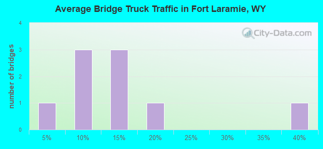
- 1,162Total average daily truck traffic
- 8,283Total future (year 2030) average daily traffic
- National Bridge Inventory (NBI) Registered Bridges for Fort Laramie
- No street view available for this location
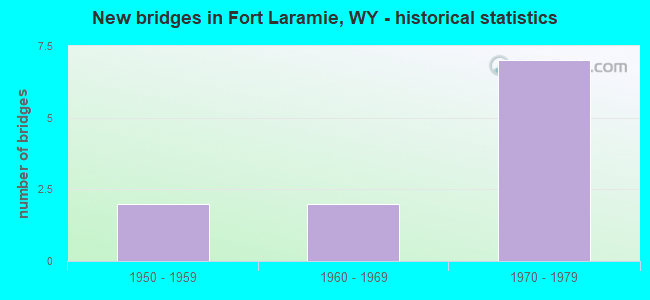
- New bridges - historical statistics
- 21950-1959
- 21960-1969
- 71970-1979
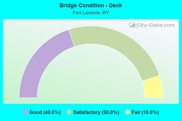
- Bridge Condition - Deck
- 40.0%Good
- 50.0%Satisfactory
- 10.0%Fair
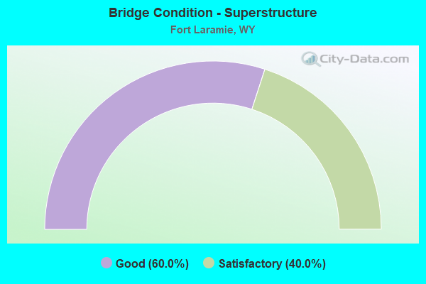
- Bridge Condition - Superstructure
- 60.0%Good
- 40.0%Satisfactory
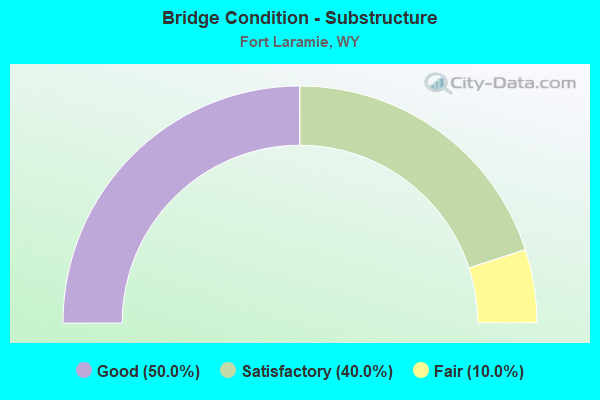
- Bridge Condition - Substructure
- 50.0%Good
- 40.0%Satisfactory
- 10.0%Fair
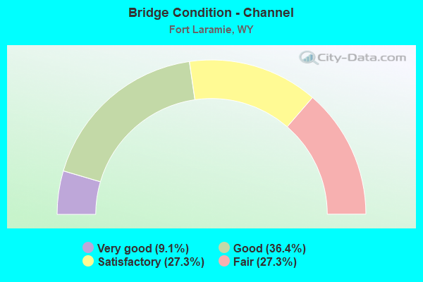
- Bridge Condition - Channel
- 9.1%Very good
- 36.4%Good
- 27.3%Satisfactory
- 27.3%Fair
Find on map >> Show street view
Structure Number: 1420001S, Location: 2.5 MILES WEST OF FORT LA (Lat: 42.201139, Lng: -104.560028), Route carried "on" structure: ServiceFederal lands road 400, Year Built: 1969, Status: Open, Structure Length: 3.05m (10.01ft), Average Daily Traffic: 25 (year 2010), Average Future Daily Traffic: 50 (year 2030), Design Load: HS 20, Features Intersected: LARAMIE RIVER, Facility Carried by Structure: SERVICE ROAD
Minimum Vertical Clearance: 30+ m (98+ ft), Kilometerpoint: 0.161, Lanes on structure: 2, Owner: National Park Service, Approaching Roadway Width: 5.8m (19.0ft), Material/Design: Concrete continuous, Design/Construction: Tee Beam, Number Of Spans In Main Unit: 3, Length of Maximum Span: 19.5m (64.0ft), Curb-To-Curb Width: 6.7m (22.0ft), Out-to-Out Width: 7.7m (25.3ft)
Condition: Deck: Satisfactory, Superstructure: Satisfactory, Substructure: Good, Channel: Satisfactory, Operating Rating: 39.9 metric tons, Method Used To Determine Operating Rating: Load Factor (LF), Inventory Rating: 23.6 metric tons, Method Used To Determine Inventory Rating: Load Factor (LF), Structural Evaluation: Equal to present minimum criteria, Deck Geometry: Somewhat better than minimum adequacy, Waterway Adequacy: Equal to present minimum criteria, Approach Roadway Alignment: Equal to present desirable criteria, Designated Inspection Frequency: Every 24 months, Inspection Date: October 2021, Bridge Improvement Cost: $17,000, Roadway Improvement Cost: $2,000, Total Project Cost: $26,000 ( Estimate for 2015), Deck Structure Type: Concrete Cast-file-Place, Wearing Surface/Protective System: Wearing Surface: Monolithic Concrete
Find on map >> Show street view
Structure Number: 1420003P, Location: 0.6 MILES WEST OF FORT LA (Lat: 42.199611, Lng: -104.536333), Route carried "on" structure: Federal lands road , Year Built: 1976, Status: Open, Structure Length: 5.94m (19.49ft), Average Daily Traffic: 50 (year 2010), Truck Traffic: 1%, Average Future Daily Traffic: 125 (year 2030), Design Load: HS 20, Features Intersected: LARAMIE RIVER, Facility Carried by Structure: ENTRANCE ROAD (FUT
Minimum Vertical Clearance: 30+ m (98+ ft), Kilometerpoint: 0.966, Lanes on structure: 2, Owner: National Park Service, Maintenance Responsibility: State Highway Agency, Approaching Roadway Width: 9.1m (29.9ft), Material/Design: Prestressed concrete continuous, Design/Construction: Stringer/Multi-beam, Number Of Spans In Main Unit: 3, Length of Maximum Span: 22.9m (75.1ft), Curb-To-Curb Width: 9.1m (29.9ft), Out-to-Out Width: 10.0m (32.8ft)
Condition: Deck: Good, Superstructure: Good, Substructure: Good, Channel: Fair, Operating Rating: 67.1 metric tons, Method Used To Determine Operating Rating: Load Factor (LF), Inventory Rating: 34.5 metric tons, Method Used To Determine Inventory Rating: Load Factor (LF), Structural Evaluation: Better than present minimum criteria, Deck Geometry: Better than present minimum criteria, Waterway Adequacy: Better than present minimum criteria, Approach Roadway Alignment: Equal to present desirable criteria, Designated Inspection Frequency: Every 24 months, Inspection Date: October 2021, Bridge Improvement Cost: $9,000, Roadway Improvement Cost: $1,000, Total Project Cost: $14,000 ( Estimate for 2015), Deck Structure Type: Concrete Cast-file-Place, Wearing Surface/Protective System: Wearing Surface: Monolithic Concrete
Find on map >> Show street view
Structure Number: 1420004P, Location: 2.5 MILES WEST OF FORT LA (Lat: 42.198361, Lng: -104.558583), Route carried "on" structure: Federal lands road , Year Built: 1976, Status: Open, Structure Length: 0.69m (2.26ft), Average Daily Traffic: 50 (year 2011), Average Future Daily Traffic: 125 (year 2031), Design Load: HS 20, Features Intersected: DEER CREEK, Facility Carried by Structure: SERVICE ROAD
Minimum Vertical Clearance: 30+ m (98+ ft), Kilometerpoint: 1.287, Lanes on structure: 2, Owner: National Park Service, Approaching Roadway Width: 5.2m (17.1ft), Material/Design: Concrete, Design/Construction: Culvert, Number Of Spans In Main Unit: 2, Length of Maximum Span: 3.0m (9.8ft)
Condition: Channel: Satisfactory, Culverts: Satisfactory, Operating Rating: 54.5 metric tons, Method Used To Determine Operating Rating: Field evaluation and documented engineering judgment, Inventory Rating: 32.7 metric tons, Method Used To Determine Inventory Rating: Field evaluation and documented engineering judgment, Structural Evaluation: Equal to present minimum criteria, Waterway Adequacy: Better than present minimum criteria, Approach Roadway Alignment: Equal to present desirable criteria, Designated Inspection Frequency: Every 24 months, Inspection Date: October 2021, Bridge Improvement Cost: $9,000, Roadway Improvement Cost: $1,000, Total Project Cost: $14,000 ( Estimate for 2015)
Find on map >> Show street view
Structure Number: BXQ, Location: Guernsey - Lingle (Lat: 42.235311, Lng: -104.556097), Route carried "on" structure: US 26, Year Built: 1969, Status: Open, Structure Length: 3.96m (12.99ft), Average Daily Traffic: 1,652 (year 2021), Truck Traffic: 36%, Average Future Daily Traffic: 2,313 (year 2041), Design Load: HS 20, Features Intersected: Unnamed Draw
Minimum Vertical Clearance: 30+ m (98+ ft), Kilometerpoint: 40.811, Lanes on structure: 2, Base Highway Network: Yes, Owner: State Highway Agency, Approaching Roadway Width: 12.2m (40.0ft), Skew: 3 degrees, Material/Design: Steel continuous, Design/Construction: Stringer/Multi-beam, Number Of Spans In Main Unit: 3, Length of Maximum Span: 15.2m (49.9ft), Curb-To-Curb Width: 12.2m (40.0ft), Out-to-Out Width: 13.0m (42.7ft)
Condition: Deck: Good, Superstructure: Good, Substructure: Good, Channel: Very good, Operating Rating: 54.4 metric tons, Method Used To Determine Operating Rating: Load Factor (LF), Inventory Rating: 35.4 metric tons, Method Used To Determine Inventory Rating: Load Factor (LF), Structural Evaluation: Better than present minimum criteria, Deck Geometry: Better than present minimum criteria, Waterway Adequacy: Equal to present desirable criteria, Approach Roadway Alignment: Equal to present desirable criteria, Length Of Structure Improvement: 1.22m (4.00ft), Designated Inspection Frequency: Every 24 months, Inspection Date: April 2021, Bridge Improvement Cost: $20,000, Roadway Improvement Cost: $2,000, Total Project Cost: $30,000 ( Estimate for 2014), Deck Structure Type: Concrete Cast-file-Place, Wearing Surface/Protective System: Wearing Surface: Latex Concrete
Find on map >> Show street view
Structure Number: BXR, Location: Guernsey - Lingle (Lat: 42.189600, Lng: -104.464069), Route carried "on" structure: US 26, Year Built: 1954, Status: Posted for load, Structure Length: 2.06m (6.76ft), Average Daily Traffic: 2,547 (year 2021), Truck Traffic: 17%, Average Future Daily Traffic: 3,566 (year 2041), Design Load: H 20, Features Intersected: Sand Draw
Minimum Vertical Clearance: 30+ m (98+ ft), Kilometerpoint: 50.096, Lanes on structure: 2, Base Highway Network: Yes, Owner: State Highway Agency, Approaching Roadway Width: 9.8m (32.2ft), Material/Design: Concrete continuous, Design/Construction: Slab, Number Of Spans In Main Unit: 3, Length of Maximum Span: 7.6m (24.9ft), Curb-To-Curb Width: 9.8m (32.2ft), Out-to-Out Width: 10.7m (35.1ft)
Condition: Deck: Satisfactory, Superstructure: Satisfactory, Substructure: Satisfactory, Channel: Satisfactory, Operating Rating: 39.2 metric tons, Method Used To Determine Operating Rating: Load Factor (LF), Inventory Rating: 23.5 metric tons, Method Used To Determine Inventory Rating: Load Factor (LF), Structural Evaluation: Equal to present minimum criteria, Deck Geometry: Meets minimum limits, Waterway Adequacy: Equal to present desirable criteria, Approach Roadway Alignment: Equal to present desirable criteria, Designated Inspection Frequency: Every 24 months, Inspection Date: April 2021, Deck Structure Type: Concrete Cast-file-Place, Wearing Surface/Protective System: Wearing Surface: Bituminous
Find on map >> Show street view
Structure Number: CPN, Location: Fort Laramie - West (Lat: 42.210836, Lng: -104.533333), Route carried "on" structure: State highway 160, Year Built: 1958, Status: Open, Structure Length: 12.92m (42.39ft), Average Daily Traffic: 377 (year 2021), Truck Traffic: 10%, Average Future Daily Traffic: 528 (year 2041), Design Load: HS 20, Features Intersected: North Platte River
Minimum Vertical Clearance: 30+ m (98+ ft), Kilometerpoint: 1.244, Lanes on structure: 2, Owner: State Highway Agency, Approaching Roadway Width: 7.6m (24.9ft), Material/Design: Concrete continuous, Design/Construction: Tee Beam, Number Of Spans In Main Unit: 6, Length of Maximum Span: 22.6m (74.1ft), Curb-To-Curb Width: 9.1m (29.9ft), Out-to-Out Width: 11.2m (36.7ft)
Condition: Deck: Satisfactory, Superstructure: Satisfactory, Substructure: Good, Channel: Good, Operating Rating: 43.5 metric tons, Method Used To Determine Operating Rating: Load Factor (LF), Inventory Rating: 26.3 metric tons, Method Used To Determine Inventory Rating: Load Factor (LF), Structural Evaluation: Equal to present minimum criteria, Deck Geometry: Equal to present minimum criteria, Waterway Adequacy: Equal to present desirable criteria, Approach Roadway Alignment: Equal to present desirable criteria, Designated Inspection Frequency: Every 24 months, Underwater Inspection Frequency: Every 60 months, Inspection Date: April 2021, Underwater Inspection Date: October 2019, Deck Structure Type: Concrete Cast-file-Place
Find on map >> Show street view
Structure Number: FAL, Location: Ft. Laramie (Lat: 42.218197, Lng: -104.517714), Route carried "on" structure: County highway 15G, Year Built: 1973, Status: Open, Structure Length: 3.02m (9.91ft), Average Daily Traffic: 196 (year 2021), Truck Traffic: 8%, Average Future Daily Traffic: 274 (year 2041), Design Load: HS 20, Features Intersected: Interstate Canal
Minimum Vertical Clearance: 30+ m (98+ ft), Kilometerpoint: 0.209, Lanes on structure: 2, Owner: County Highway Agency, Approaching Roadway Width: 6.1m (20.0ft), Skew: 3 degrees, Material/Design: Concrete, Design/Construction: Tee Beam, Number Of Spans In Main Unit: 3, Length of Maximum Span: 9.4m (30.8ft), Curb-To-Curb Width: 6.9m (22.6ft), Out-to-Out Width: 7.3m (24.0ft)
Condition: Deck: Good, Superstructure: Good, Substructure: Fair, Channel: Good, Operating Rating: 52.3 metric tons, Method Used To Determine Operating Rating: Field evaluation and documented engineering judgment, Inventory Rating: 31.4 metric tons, Method Used To Determine Inventory Rating: Field evaluation and documented engineering judgment, Structural Evaluation: Somewhat better than minimum adequacy, Deck Geometry: Meets minimum limits, Waterway Adequacy: Equal to present desirable criteria, Approach Roadway Alignment: Equal to present desirable criteria, Length Of Structure Improvement: 7.59m (24.90ft), Designated Inspection Frequency: Every 24 months, Inspection Date: January 2022, Bridge Improvement Cost: $28,000, Roadway Improvement Cost: $30,000, Total Project Cost: $72,000 ( Estimate for 2014), Deck Structure Type: Concrete Precast Panels, Wearing Surface/Protective System: Wearing Surface: Bituminous
Find on map >> Show street view
Structure Number: FAM, Location: 1 Mi. S. Of Ft. Laramie (Lat: 42.194250, Lng: -104.528872), Route carried "on" structure: County highway 15E, Year Built: 1973, Status: Open, Structure Length: 2.93m (9.61ft), Average Daily Traffic: 88 (year 2021), Truck Traffic: 6%, Average Future Daily Traffic: 123 (year 2041), Design Load: HS 20, Features Intersected: Fort Laramie Canal
Minimum Vertical Clearance: 30+ m (98+ ft), Kilometerpoint: 2.148, Lanes on structure: 2, Owner: County Highway Agency, Approaching Roadway Width: 5.5m (18.0ft), Material/Design: Concrete, Design/Construction: Tee Beam, Number Of Spans In Main Unit: 3, Length of Maximum Span: 9.1m (29.9ft), Curb-To-Curb Width: 5.0m (16.4ft), Out-to-Out Width: 5.5m (18.0ft)
Condition: Deck: Satisfactory, Superstructure: Satisfactory, Substructure: Satisfactory, Channel: Good, Operating Rating: 54.5 metric tons, Method Used To Determine Operating Rating: Field evaluation and documented engineering judgment, Inventory Rating: 32.7 metric tons, Method Used To Determine Inventory Rating: Field evaluation and documented engineering judgment, Structural Evaluation: Equal to present minimum criteria, Deck Geometry: High priority of corrective action, Waterway Adequacy: Equal to present desirable criteria, Approach Roadway Alignment: High priority of corrective action, Length Of Structure Improvement: 7.50m (24.61ft), Designated Inspection Frequency: Every 24 months, Inspection Date: January 2022, Bridge Improvement Cost: $27,000, Roadway Improvement Cost: $30,000, Total Project Cost: $60,000 ( Estimate for 2014), Deck Structure Type: Concrete Precast Panels
Find on map >> Show street view
Structure Number: FAN, Location: 3 Mi. W. Of Ft. Laramie (Lat: 42.198886, Lng: -104.567167), Route carried "on" structure: County highway 84A, Year Built: 1973, Status: Open, Structure Length: 3.66m (12.01ft), Average Daily Traffic: 377 (year 2021), Truck Traffic: 10%, Average Future Daily Traffic: 528 (year 2041), Design Load: HS 20, Features Intersected: Laramie River
Minimum Vertical Clearance: 30+ m (98+ ft), Kilometerpoint: 3.269, Lanes on structure: 2, Owner: County Highway Agency, Approaching Roadway Width: 6.1m (20.0ft), Material/Design: Concrete, Design/Construction: Tee Beam, Number Of Spans In Main Unit: 3, Length of Maximum Span: 11.6m (38.1ft), Curb-To-Curb Width: 5.1m (16.7ft), Out-to-Out Width: 5.5m (18.0ft)
Condition: Deck: Satisfactory, Superstructure: Good, Substructure: Satisfactory, Channel: Fair, Operating Rating: 54.5 metric tons, Method Used To Determine Operating Rating: Field evaluation and documented engineering judgment, Inventory Rating: 32.7 metric tons, Method Used To Determine Inventory Rating: Field evaluation and documented engineering judgment, Structural Evaluation: Equal to present minimum criteria, Deck Geometry: High priority of replacement, Waterway Adequacy: Equal to present desirable criteria, Approach Roadway Alignment: Somewhat better than minimum adequacy, Length Of Structure Improvement: 8.23m (27.00ft), Designated Inspection Frequency: Every 24 months, Inspection Date: January 2022, Bridge Improvement Cost: $27,000, Roadway Improvement Cost: $30,000, Total Project Cost: $60,000 ( Estimate for 2014), Deck Structure Type: Concrete Precast Panels
Find on map >> Show street view
Structure Number: FAO, Location: 3 Mi. S.W. Of Ft Laramie (Lat: 42.196394, Lng: -104.571650), Route carried "on" structure: County highway 84A, Year Built: 1973, Status: Open, Structure Length: 2.13m (6.99ft), Average Daily Traffic: 377 (year 2021), Truck Traffic: 10%, Average Future Daily Traffic: 528 (year 2041), Design Load: HS 20, Features Intersected: Fort Laramie Canal
Minimum Vertical Clearance: 30+ m (98+ ft), Kilometerpoint: 3.779, Lanes on structure: 2, Owner: County Highway Agency, Approaching Roadway Width: 7.3m (24.0ft), Material/Design: Prestressed concrete, Design/Construction: Tee Beam, Number Of Spans In Main Unit: 2, Length of Maximum Span: 10.1m (33.1ft), Curb or Sidewalk Widths: Left: 0.2m (0.7ft), Right: 0.2m (0.7ft), Curb-To-Curb Width: 5.1m (16.7ft), Out-to-Out Width: 5.5m (18.0ft)
Condition: Deck: Fair, Superstructure: Good, Substructure: Good, Channel: Good, Operating Rating: 54.5 metric tons, Method Used To Determine Operating Rating: Field evaluation and documented engineering judgment, Inventory Rating: 32.7 metric tons, Method Used To Determine Inventory Rating: Field evaluation and documented engineering judgment, Structural Evaluation: Better than present minimum criteria, Deck Geometry: High priority of replacement, Waterway Adequacy: Equal to present desirable criteria, Approach Roadway Alignment: Meets minimum limits, Length Of Structure Improvement: 6.71m (22.01ft), Designated Inspection Frequency: Every 24 months, Inspection Date: January 2022, Bridge Improvement Cost: $14,000, Roadway Improvement Cost: $30,000, Total Project Cost: $46,000 ( Estimate for 2014), Deck Structure Type: Concrete Precast Panels
Find on map >> Show street view
Structure Number: FHA, Location: 1 Mile Sw. Of Ft. Laramie (Lat: 42.200964, Lng: -104.535717), Route carried "on" structure: County highway 15E, Year Built: 1977, Status: Open, Structure Length: 5.94m (19.49ft), Average Daily Traffic: 88 (year 2021), Truck Traffic: 6%, Average Future Daily Traffic: 123 (year 2041), Design Load: HS 20, Features Intersected: Laramie River
Minimum Vertical Clearance: 30+ m (98+ ft), Kilometerpoint: 1.030, Lanes on structure: 2, Owner: County Highway Agency, Approaching Roadway Width: 7.9m (25.9ft), Skew: 1 degrees, Material/Design: Prestressed concrete, Design/Construction: Stringer/Multi-beam, Number Of Spans In Main Unit: 3, Length of Maximum Span: 22.9m (75.1ft), Curb-To-Curb Width: 9.2m (30.2ft), Out-to-Out Width: 10.1m (33.1ft)
Condition: Deck: Good, Superstructure: Good, Substructure: Satisfactory, Channel: Fair, Operating Rating: 54.5 metric tons, Method Used To Determine Operating Rating: Field evaluation and documented engineering judgment, Inventory Rating: 32.7 metric tons, Method Used To Determine Inventory Rating: Field evaluation and documented engineering judgment, Structural Evaluation: Equal to present minimum criteria, Deck Geometry: Better than present minimum criteria, Waterway Adequacy: Equal to present desirable criteria, Approach Roadway Alignment: Equal to present desirable criteria, Length Of Structure Improvement: 0.18m (0.59ft), Designated Inspection Frequency: Every 24 months, Underwater Inspection Frequency: Every 60 months, Inspection Date: January 2022, Underwater Inspection Date: October 2019, Bridge Improvement Cost: $1,000, Roadway Improvement Cost: $30,000, Total Project Cost: $32,000 ( Estimate for 2014), Deck Structure Type: Concrete Cast-file-Place