Bridge Statistics for Foscoe, North Carolina (NC)
Condition, Traffic, Stress, Structural Evaluation, Project Costs
- National Bridge Inventory (NBI) Statistics
- 18Number of bridges
- 279ft / 85.4mTotal length
- $3,045,000Total costs
- 32,715Total average daily traffic
- 2,949Total average daily truck traffic
- 49,245Total future (year 2031) average daily traffic
- National Bridge Inventory (NBI) Registered Bridges for Foscoe
- No street view available for this location
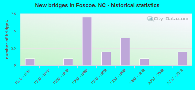
- New bridges - historical statistics
- 11930-1939
- 11950-1959
- 71960-1969
- 21970-1979
- 41980-1989
- 11990-1999
- 22010-2019


- Bridge Condition - Deck
- 6.3%Very good
- 43.8%Good
- 37.5%Satisfactory
- 12.5%Fair

- Bridge Condition - Superstructure
- 5.9%Very good
- 64.7%Good
- 11.8%Satisfactory
- 11.8%Fair
- 5.9%Poor

- Bridge Condition - Substructure
- 5.9%Very good
- 58.8%Good
- 17.6%Satisfactory
- 17.6%Fair

- Bridge Condition - Channel
- 43.8%Very good
- 50.0%Good
- 6.3%Satisfactory
Find on map >> Show street view
Structure Number: 110154, Location: 2.2 MI.E.JCT.US221 (Lat: 36.090508, Lng: -81.802547), Route carried "on" structure: State highway 1514, Year Built: 1935, Status: Open, Structure Length: 0.82m (2.69ft), Average Daily Traffic: 190 (year 2015), Truck Traffic: 6%, Average Future Daily Traffic: 380 (year 2040), Design Load: H 15, Features Intersected: WILSON CREEK
Minimum Vertical Clearance: 30+ m (98+ ft), Kilometerpoint: 0.000, Lanes on structure: 2, Owner: State Highway Agency, Approaching Roadway Width: 4.2m (13.8ft), Material/Design: Concrete, Design/Construction: Frame, Number Of Spans In Main Unit: 1, Length of Maximum Span: 7.9m (25.9ft), Curb or Sidewalk Widths: Left: 0.1m (0.3ft), Right: 0.1m (0.3ft), Curb-To-Curb Width: 6.0m (19.7ft), Out-to-Out Width: 6.4m (21.0ft)
Condition: Deck: Fair, Superstructure: Fair, Substructure: Fair, Channel: Good, Operating Rating: 29.9 metric tons, Method Used To Determine Operating Rating: Field evaluation and documented engineering judgment, Inventory Rating: 22.6 metric tons, Method Used To Determine Inventory Rating: Field evaluation and documented engineering judgment, Structural Evaluation: Somewhat better than minimum adequacy, Deck Geometry: High priority of corrective action, Waterway Adequacy: Better than present minimum criteria, Approach Roadway Alignment: Equal to present minimum criteria, Designated Inspection Frequency: Every 24 months, Inspection Date: May 2021, Deck Structure Type: Concrete Cast-file-Place, Wearing Surface/Protective System: Wearing Surface: Monolithic Concrete
Find on map >> Show street view
Structure Number: 110155, Location: 1 MI.W.JCT.SR1515 (Lat: 36.083344, Lng: -81.791317), Route carried "on" structure: State highway 1514, Year Built: 1950, Status: Open, Structure Length: 1.18m (3.87ft), Average Daily Traffic: 220 (year 2016), Truck Traffic: 6%, Average Future Daily Traffic: 440 (year 2040), Design Load: H 15, Features Intersected: LITTLE WILSON CREEK
Minimum Vertical Clearance: 30+ m (98+ ft), Kilometerpoint: 0.000, Lanes on structure: 1, Owner: State Highway Agency, Approaching Roadway Width: 4.2m (13.8ft), Material/Design: Concrete, Design/Construction: Frame, Number Of Spans In Main Unit: 1, Length of Maximum Span: 11.2m (36.7ft), Curb-To-Curb Width: 3.5m (11.5ft), Out-to-Out Width: 4.2m (13.8ft)
Condition: Deck: Satisfactory, Superstructure: Satisfactory, Substructure: Good, Channel: Good, Operating Rating: 33.5 metric tons, Method Used To Determine Operating Rating: Field evaluation and documented engineering judgment, Inventory Rating: 25.4 metric tons, Method Used To Determine Inventory Rating: Field evaluation and documented engineering judgment, Structural Evaluation: Equal to present minimum criteria, Deck Geometry: High priority of replacement, Waterway Adequacy: Better than present minimum criteria, Approach Roadway Alignment: Equal to present minimum criteria, Designated Inspection Frequency: Every 24 months, Inspection Date: May 2021, Deck Structure Type: Concrete Cast-file-Place, Wearing Surface/Protective System: Wearing Surface: Monolithic Concrete
Find on map >> Show street view
Structure Number: 1890003, Location: .1 MI.E.JCT.SR1568 (Lat: 36.173606, Lng: -81.745742), Route carried "on" structure: State highway 1557, Year Built: 1966, Status: Posted for load, Structure Length: 4.57m (14.99ft), Average Daily Traffic: 1,500 (year 2015), Truck Traffic: 6%, Average Future Daily Traffic: 3,000 (year 2040), Design Load: H 10, Features Intersected: WATAUGA RIVER
Minimum Vertical Clearance: 30+ m (98+ ft), Kilometerpoint: 0.000, Lanes on structure: 2, Owner: State Highway Agency, Approaching Roadway Width: 6.0m (19.7ft), Skew: 1 degrees, Material/Design: Steel, Design/Construction: Stringer/Multi-beam, Number Of Spans In Main Unit: 3, Length of Maximum Span: 14.9m (48.9ft), Curb-To-Curb Width: 9.1m (29.9ft), Out-to-Out Width: 9.9m (32.5ft)
Condition: Deck: Satisfactory, Superstructure: Good, Substructure: Good, Channel: Good, Operating Rating: 33.5 metric tons, Method Used To Determine Operating Rating: Load Factor (LF), Inventory Rating: 19.9 metric tons, Method Used To Determine Inventory Rating: Load Factor (LF), Structural Evaluation: Somewhat better than minimum adequacy, Deck Geometry: Somewhat better than minimum adequacy, Waterway Adequacy: Equal to present desirable criteria, Approach Roadway Alignment: Equal to present desirable criteria, Bridge Posting: Required (Relationship of Operating Rating to Maximum Legal Load: 20.0 - 29.9% below), Designated Inspection Frequency: Every 24 months, Inspection Date: August 2021, Deck Structure Type: Concrete Cast-file-Place, Wearing Surface/Protective System: Wearing Surface: Monolithic Concrete
Find on map >> Show street view
Structure Number: 1890006, Location: 0.1 MI.S.JCT.NC 105 (Lat: 36.156639, Lng: -81.769606), Route carried "on" structure: State highway 1559, Year Built: 2014, Status: Open, Structure Length: 3.90m (12.80ft), Average Daily Traffic: 930 (year 2016), Truck Traffic: 6%, Average Future Daily Traffic: 1,860 (year 2040), Design Load: HL 93, Features Intersected: WATAUGA RIVER
Minimum Vertical Clearance: 30+ m (98+ ft), Kilometerpoint: 0.000, Lanes on structure: 2, Owner: State Highway Agency, Approaching Roadway Width: 6.0m (19.7ft), Material/Design: Prestressed concrete, Design/Construction: Slab, Number Of Spans In Main Unit: 3, Length of Maximum Span: 13.4m (44.0ft), Curb-To-Curb Width: 8.3m (27.2ft), Out-to-Out Width: 9.1m (29.9ft)
Condition: Deck: Good, Superstructure: Good, Substructure: Good, Channel: Very good, Operating Rating: 60.7 metric tons, Method Used To Determine Operating Rating: Load and Resistance Factor (LRFR), Inventory Rating: 43.5 metric tons, Method Used To Determine Inventory Rating: Load and Resistance Factor (LRFR), Structural Evaluation: Better than present minimum criteria, Deck Geometry: Somewhat better than minimum adequacy, Waterway Adequacy: Better than present minimum criteria, Approach Roadway Alignment: Equal to present desirable criteria, Designated Inspection Frequency: Every 24 months, Inspection Date: September 2021, Deck Structure Type: Concrete Precast Panels, Wearing Surface/Protective System: Wearing Surface: Bituminous
Find on map >> Show street view
Structure Number: 1890055, Location: 0.2 MI.E.JCT.SR1558 (Lat: 36.173147, Lng: -81.739586), Route carried "on" structure: State highway 1557, Year Built: 2017, Status: Open, Structure Length: 1.12m (3.67ft), Average Daily Traffic: 1,500 (year 2015), Truck Traffic: 6%, Average Future Daily Traffic: 3,000 (year 2040), Design Load: H 10, Features Intersected: LANCE CREEK
Minimum Vertical Clearance: 30+ m (98+ ft), Kilometerpoint: 0.000, Lanes on structure: 2, Owner: State Highway Agency, Approaching Roadway Width: 5.7m (18.7ft), Material/Design: Prestressed concrete, Design/Construction: Slab, Number Of Spans In Main Unit: 1, Length of Maximum Span: 10.3m (33.8ft), Curb-To-Curb Width: 8.8m (28.9ft), Out-to-Out Width: 10.0m (32.8ft)
Condition: Deck: Very good, Superstructure: Very good, Substructure: Very good, Channel: Good, Operating Rating: 49.8 metric tons, Method Used To Determine Operating Rating: Load and Resistance Factor (LRFR), Inventory Rating: 38.1 metric tons, Method Used To Determine Inventory Rating: Load and Resistance Factor (LRFR), Structural Evaluation: Equal to present desirable criteria, Deck Geometry: Somewhat better than minimum adequacy, Waterway Adequacy: Better than present minimum criteria, Approach Roadway Alignment: Equal to present desirable criteria, Designated Inspection Frequency: Every 24 months, Inspection Date: July 2021, Deck Structure Type: Concrete Precast Panels, Wearing Surface/Protective System: Wearing Surface: Bituminous
Find on map >> Show street view
Structure Number: 1890148, Location: .3 MI.W.JCT.US221 (Lat: 36.123158, Lng: -81.769850), Route carried "on" structure: State highway 1561, Year Built: 1966, Status: Posted for load, Structure Length: 0.94m (3.08ft), Average Daily Traffic: 60 (year 2000), Average Future Daily Traffic: 120 (year 2040), Features Intersected: BOONE FORK CREEK
Minimum Vertical Clearance: 30+ m (98+ ft), Kilometerpoint: 0.000, Lanes on structure: 2, Owner: State Highway Agency, Approaching Roadway Width: 3.6m (11.8ft), Material/Design: Steel, Design/Construction: Stringer/Multi-beam, Number Of Spans In Main Unit: 1, Length of Maximum Span: 8.8m (28.9ft), Curb-To-Curb Width: 5.8m (19.0ft), Out-to-Out Width: 6.1m (20.0ft)
Condition: Deck: Fair, Superstructure: Poor, Substructure: Fair, Channel: Good, Operating Rating: 10.8 metric tons, Method Used To Determine Operating Rating: Load Factor (LF), Inventory Rating: 6.3 metric tons, Method Used To Determine Inventory Rating: Load Factor (LF), Structural Evaluation: High priority of replacement, Deck Geometry: Meets minimum limits, Waterway Adequacy: Better than present minimum criteria, Approach Roadway Alignment: Equal to present desirable criteria, Bridge Posting: Required (Relationship of Operating Rating to Maximum Legal Load: > 39.9% below), Designated Inspection Frequency: Every 24 months, Inspection Date: August 2021, Deck Structure Type: Wood or Timber, Wearing Surface/Protective System: Wearing Surface: Bituminous
Find on map >> Show street view
Structure Number: 1890197, Location: 180 FT .W.JCT.SR1559 (Lat: 36.146447, Lng: -81.767744), Route carried "on" structure: State highway 1560, Year Built: 1962, Status: Posted for load, Structure Length: 0.97m (3.18ft), Average Daily Traffic: 80 (year 1996), Average Future Daily Traffic: 160 (year 2040), Features Intersected: MOODY MILL CREEK
Minimum Vertical Clearance: 30+ m (98+ ft), Kilometerpoint: 0.000, Lanes on structure: 2, Owner: State Highway Agency, Approaching Roadway Width: 5.1m (16.7ft), Material/Design: Steel, Design/Construction: Stringer/Multi-beam, Number Of Spans In Main Unit: 1, Length of Maximum Span: 8.8m (28.9ft), Curb-To-Curb Width: 5.8m (19.0ft), Out-to-Out Width: 6.0m (19.7ft)
Condition: Deck: Good, Superstructure: Satisfactory, Substructure: Satisfactory, Channel: Good, Operating Rating: 45.3 metric tons, Method Used To Determine Operating Rating: Load Factor (LF), Inventory Rating: 27.2 metric tons, Method Used To Determine Inventory Rating: Load Factor (LF), Structural Evaluation: Equal to present minimum criteria, Deck Geometry: Meets minimum limits, Waterway Adequacy: Better than present minimum criteria, Approach Roadway Alignment: Equal to present minimum criteria, Bridge Posting: Required (Relationship of Operating Rating to Maximum Legal Load: 0.1 - 9.9% below), Designated Inspection Frequency: Every 24 months, Inspection Date: August 2021, Deck Structure Type: Wood or Timber, Wearing Surface/Protective System: Wearing Surface: Bituminous
Find on map >> Show street view
Structure Number: 1890298, Location: 0.1 MI.S.JCT.NC105 (Lat: 36.160419, Lng: -81.763694), Route carried "on" structure: State highway 1580, Year Built: 1994, Status: Open, Structure Length: 4.11m (13.48ft), Average Daily Traffic: 400 (year 2000), Truck Traffic: 6%, Average Future Daily Traffic: 800 (year 2040), Design Load: HS 20+Mod, Features Intersected: WATAUGA RIVER
Minimum Vertical Clearance: 30+ m (98+ ft), Kilometerpoint: 0.000, Lanes on structure: 2, Owner: State Highway Agency, Approaching Roadway Width: 6.7m (22.0ft), Skew: 9 degrees, Material/Design: Prestressed concrete, Design/Construction: Stringer/Multi-beam, Number Of Spans In Main Unit: 3, Length of Maximum Span: 16.4m (53.8ft), Curb-To-Curb Width: 8.5m (27.9ft), Out-to-Out Width: 9.4m (30.8ft)
Condition: Deck: Good, Superstructure: Good, Substructure: Satisfactory, Channel: Good, Operating Rating: 66.2 metric tons, Method Used To Determine Operating Rating: Load Factor (LF), Inventory Rating: 38.1 metric tons, Method Used To Determine Inventory Rating: Load Factor (LF), Structural Evaluation: Equal to present minimum criteria, Deck Geometry: Equal to present minimum criteria, Waterway Adequacy: Better than present minimum criteria, Approach Roadway Alignment: Equal to present desirable criteria, Designated Inspection Frequency: Every 24 months, Underwater Inspection Frequency: Every 60 months, Inspection Date: August 2021, Underwater Inspection Date: June 2019, Deck Structure Type: Concrete Cast-file-Place, Wearing Surface/Protective System: Wearing Surface: Monolithic Concrete, Deck Protection: Epoxy Coated Reinforcing
Find on map >> Show street view
Structure Number: 1890319, Location: 0.2 MI.S.JCT.NC105 (Lat: 36.146219, Lng: -81.791264), Route carried "on" structure: State highway 1594, Year Built: 1965, Status: Posted for load, Structure Length: 1.88m (6.17ft), Average Daily Traffic: 350 (year 1996), Truck Traffic: 6%, Average Future Daily Traffic: 700 (year 2040), Features Intersected: WATAUGA RIVER
Minimum Vertical Clearance: 30+ m (98+ ft), Kilometerpoint: 0.000, Lanes on structure: 2, Owner: State Highway Agency, Approaching Roadway Width: 5.4m (17.7ft), Material/Design: Steel, Design/Construction: Stringer/Multi-beam, Number Of Spans In Main Unit: 2, Length of Maximum Span: 9.1m (29.9ft), Curb or Sidewalk Widths: Left: 0.1m (0.3ft), Right: 0.1m (0.3ft), Curb-To-Curb Width: 5.1m (16.7ft), Out-to-Out Width: 5.4m (17.7ft)
Condition: Deck: Good, Superstructure: Fair, Substructure: Satisfactory, Channel: Good, Operating Rating: 23.5 metric tons, Method Used To Determine Operating Rating: Load Factor (LF), Inventory Rating: 13.6 metric tons, Method Used To Determine Inventory Rating: Load Factor (LF), Structural Evaluation: Meets minimum limits, Deck Geometry: High priority of replacement, Waterway Adequacy: Equal to present minimum criteria, Approach Roadway Alignment: Equal to present desirable criteria, Bridge Posting: Required (Relationship of Operating Rating to Maximum Legal Load: > 39.9% below), Designated Inspection Frequency: Every 24 months, Inspection Date: August 2021, Deck Structure Type: Wood or Timber, Wearing Surface/Protective System: Wearing Surface: Bituminous
Find on map >> Show street view
Structure Number: 1890378, Location: .2 MI.S.JCT.SR1151 (Lat: 36.144131, Lng: -81.799908), Route carried "on" structure: State highway 105, Year Built: 1960, Status: Open, Structure Length: 0.67m (2.20ft), Average Daily Traffic: 9,500 (year 2015), Truck Traffic: 14%, Average Future Daily Traffic: 19,000 (year 2040), Design Load: HS 20+Mod, Features Intersected: VALLEY CREEK
Minimum Vertical Clearance: 30+ m (98+ ft), Kilometerpoint: 0.000, Lanes on structure: 2, Owner: State Highway Agency, Approaching Roadway Width: 8.5m (27.9ft), Skew: 2 degrees, Material/Design: Aluminum, Iron, Design/Construction: Culvert, Number Of Spans In Main Unit: 2, Length of Maximum Span: 2.7m (8.9ft)
Condition: Channel: Satisfactory, Culverts: Very good, Operating Rating: 89.8 metric tons, Method Used To Determine Operating Rating: Load and Resistance Factor (LRFR), Inventory Rating: 89.8 metric tons, Method Used To Determine Inventory Rating: Load and Resistance Factor (LRFR), Structural Evaluation: Equal to present desirable criteria, Waterway Adequacy: Equal to present minimum criteria, Approach Roadway Alignment: Equal to present desirable criteria, Designated Inspection Frequency: Every 24 months, Inspection Date: July 2021
Find on map >> Show street view
Structure Number: 5140097P, Location: 9.4 MILES FROM U. S. ROUT (Lat: 36.138944, Lng: -81.731722), Route carried "on" structure: Federal lands road 1, Year Built: 1960, Status: Open, Structure Length: 3.35m (10.99ft), Average Daily Traffic: 2,397 (year 2011), Truck Traffic: 1%, Average Future Daily Traffic: 2,637 (year 2031), Design Load: H 15, Features Intersected: PRICE LAKE DAM, Facility Carried by Structure: BLUE RIDGE PARKWAY
Minimum Vertical Clearance: 30+ m (98+ ft), Kilometerpoint: 477.396, Lanes on structure: 2, Owner: National Park Service, Approaching Roadway Width: 10.4m (34.1ft), Material/Design: Concrete continuous, Design/Construction: Slab, Number Of Spans In Main Unit: 3, Length of Maximum Span: 12.2m (40.0ft), Curb or Sidewalk Widths: Left: 1.5m (4.9ft), Right: 0.9m (3.0ft), Curb-To-Curb Width: 7.9m (25.9ft), Out-to-Out Width: 11.1m (36.4ft)
Condition: Deck: Good, Superstructure: Good, Substructure: Fair, Channel: Very good, Operating Rating: 31.4 metric tons, Method Used To Determine Operating Rating: Load Factor (LF), Inventory Rating: 18.8 metric tons, Method Used To Determine Inventory Rating: Load Factor (LF), Structural Evaluation: Somewhat better than minimum adequacy, Deck Geometry: High priority of corrective action, Waterway Adequacy: Superior to present desirable criteria, Approach Roadway Alignment: Equal to present desirable criteria, Designated Inspection Frequency: Every 48 months, Inspection Date: June 2021, Bridge Improvement Cost: $250,000, Roadway Improvement Cost: $25,000, Total Project Cost: $375,000 ( Estimate for 2015), Deck Structure Type: Concrete Cast-file-Place, Wearing Surface/Protective System: Wearing Surface: Bituminous
Find on map >> Show street view
Structure Number: 5140098P, Location: 7.6 MILES FROM U. S. ROUT (Lat: 36.131139, Lng: -81.761833), Route carried "on" structure: Federal lands road 1, Year Built: 1969, Status: Open, Structure Length: 2.12m (6.96ft), Average Daily Traffic: 2,397 (year 2011), Truck Traffic: 1%, Average Future Daily Traffic: 2,637 (year 2031), Design Load: H 15, Features Intersected: HOLLOWAY ROAD, Facility Carried by Structure: BLUE RIDGE PARKWAY
Minimum Vertical Clearance: 30+ m (98+ ft), Kilometerpoint: 480.540, Lanes on structure: 2, Lanes under structure: 2, Owner: National Park Service, Approaching Roadway Width: 10.1m (33.1ft), Material/Design: Concrete, Design/Construction: Arch - Deck, Number Of Spans In Main Unit: 1, Length of Maximum Span: 21.2m (69.6ft), Curb-To-Curb Width: 9.2m (30.2ft), Out-to-Out Width: 10.4m (34.1ft)
Condition: Superstructure: Good, Substructure: Good, Operating Rating: 77.1 metric tons, Method Used To Determine Operating Rating: Load Factor (LF), Inventory Rating: 46.3 metric tons, Method Used To Determine Inventory Rating: Load Factor (LF), Structural Evaluation: Better than present minimum criteria, Deck Geometry: Meets minimum limits, Underclear: Superior to present desirable criteria, Approach Roadway Alignment: Equal to present desirable criteria, Designated Inspection Frequency: Every 48 months, Inspection Date: June 2019, Bridge Improvement Cost: $130,000, Roadway Improvement Cost: $13,000, Total Project Cost: $195,000 ( Estimate for 2019)
Find on map >> Show street view
Structure Number: 5140174P, Location: 5.06 MILES FROM U.S. ROUT (Lat: 36.119333, Lng: -81.781250), Route carried "on" structure: Federal lands road 1, Year Built: 1971, Status: Open, Structure Length: 6.16m (20.21ft), Average Daily Traffic: 2,397 (year 2013), Truck Traffic: 1%, Average Future Daily Traffic: 2,637 (year 2033), Design Load: H 15, Features Intersected: BOONE FORK, Facility Carried by Structure: BLUE RIDGE PARKWAY
Minimum Vertical Clearance: 30+ m (98+ ft), Kilometerpoint: 482.787, Lanes on structure: 2, Owner: National Park Service, Approaching Roadway Width: 10.1m (33.1ft), Material/Design: Concrete continuous, Design/Construction: Tee Beam, Number Of Spans In Main Unit: 4, Length of Maximum Span: 17.4m (57.1ft), Curb-To-Curb Width: 10.5m (34.4ft), Out-to-Out Width: 11.6m (38.1ft)
Condition: Deck: Satisfactory, Superstructure: Good, Substructure: Good, Channel: Very good, Operating Rating: 28.2 metric tons, Method Used To Determine Operating Rating: Load Factor (LF), Inventory Rating: 16.9 metric tons, Method Used To Determine Inventory Rating: Load Factor (LF), Structural Evaluation: Meets minimum limits, Deck Geometry: Somewhat better than minimum adequacy, Waterway Adequacy: Superior to present desirable criteria, Approach Roadway Alignment: Equal to present desirable criteria, Designated Inspection Frequency: Every 24 months, Inspection Date: June 2021, Bridge Improvement Cost: $80,000, Roadway Improvement Cost: $8,000, Total Project Cost: $120,000 ( Estimate for 2017), Deck Structure Type: Concrete Cast-file-Place, Wearing Surface/Protective System: Wearing Surface: Monolithic Concrete
Find on map >> Show street view
Structure Number: 5140175P, Location: 4.66 MILES FROM U.S. ROUT (Lat: 36.114083, Lng: -81.779972), Route carried "on" structure: Federal lands road 1, Year Built: 1971, Status: Open, Structure Length: 9.08m (29.79ft), Average Daily Traffic: 2,397 (year 2013), Truck Traffic: 1%, Average Future Daily Traffic: 2,637 (year 2033), Design Load: H 15, Features Intersected: GREEN MOUNTAIN CREEK, Facility Carried by Structure: BLUE RIDGE PARKWAY
Minimum Vertical Clearance: 30+ m (98+ ft), Kilometerpoint: 483.254, Lanes on structure: 2, Owner: National Park Service, Approaching Roadway Width: 9.1m (29.9ft), Material/Design: Concrete continuous, Design/Construction: Box Beam or Girders - Single/Spread, Number Of Spans In Main Unit: 3, Length of Maximum Span: 35.4m (116.1ft), Curb-To-Curb Width: 10.5m (34.4ft), Out-to-Out Width: 11.6m (38.1ft)
Condition: Deck: Good, Superstructure: Good, Substructure: Good, Channel: Very good, Operating Rating: 35.9 metric tons, Method Used To Determine Operating Rating: Load Factor (LF), Inventory Rating: 21.5 metric tons, Method Used To Determine Inventory Rating: Load Factor (LF), Structural Evaluation: Somewhat better than minimum adequacy, Deck Geometry: Somewhat better than minimum adequacy, Waterway Adequacy: Superior to present desirable criteria, Approach Roadway Alignment: Equal to present desirable criteria, Designated Inspection Frequency: Every 24 months, Inspection Date: June 2021, Bridge Improvement Cost: $130,000, Roadway Improvement Cost: $13,000, Total Project Cost: $195,000 ( Estimate for 2017), Deck Structure Type: Concrete Cast-file-Place, Wearing Surface/Protective System: Wearing Surface: Monolithic Concrete
Find on map >> Show street view
Structure Number: 5140176P, Location: 2.54 MILES FROM U.S. ROUT (Lat: 36.099000, Lng: -81.790694), Route carried "on" structure: Federal lands road 1, Year Built: 1987, Status: Open, Structure Length: 8.41m (27.59ft), Average Daily Traffic: 2,397 (year 2013), Truck Traffic: 1%, Average Future Daily Traffic: 2,637 (year 2033), Design Load: HS 20, Features Intersected: RAVINE, Facility Carried by Structure: BLUE RIDGE PARKWAY
Minimum Vertical Clearance: 30+ m (98+ ft), Kilometerpoint: 486.714, Lanes on structure: 2, Owner: National Park Service, Approaching Roadway Width: 8.8m (28.9ft), Material/Design: Prestressed concrete continuous, Design/Construction: Box Beam or Girders - Single/Spread, Number Of Spans In Main Unit: 2, Length of Maximum Span: 42.1m (138.1ft), Curb-To-Curb Width: 10.6m (34.8ft), Out-to-Out Width: 11.8m (38.7ft)
Condition: Deck: Good, Superstructure: Good, Substructure: Good, Channel: Very good, Operating Rating: 54.5 metric tons, Method Used To Determine Operating Rating: Field evaluation and documented engineering judgment, Inventory Rating: 32.7 metric tons, Method Used To Determine Inventory Rating: Field evaluation and documented engineering judgment, Structural Evaluation: Better than present minimum criteria, Deck Geometry: Somewhat better than minimum adequacy, Approach Roadway Alignment: Equal to present desirable criteria, Designated Inspection Frequency: Every 24 months, Inspection Date: June 2021, Bridge Improvement Cost: $440,000, Roadway Improvement Cost: $44,000, Total Project Cost: $660,000 ( Estimate for 2017), Deck Structure Type: Concrete Cast-file-Place, Wearing Surface/Protective System: Wearing Surface: Monolithic Concrete
Find on map >> Show street view
Structure Number: 5140177P, Location: 2.38 MILES FROM U.S. ROUT (Lat: 36.098806, Lng: -81.795111), Route carried "on" structure: Federal lands road 1, Year Built: 1987, Status: Open, Structure Length: 13.59m (44.59ft), Average Daily Traffic: 2,000 (year 2013), Truck Traffic: 20%, Average Future Daily Traffic: 2,200 (year 2033), Design Load: HS 20, Features Intersected: RAVINE & STREAM, Facility Carried by Structure: BLUE RIDGE PARKWAY
Minimum Vertical Clearance: 30+ m (98+ ft), Kilometerpoint: 486.955, Lanes on structure: 2, Owner: National Park Service, Approaching Roadway Width: 8.5m (27.9ft), Material/Design: Prestressed concrete continuous, Design/Construction: Box Beam or Girders - Single/Spread, Number Of Spans In Main Unit: 3, Length of Maximum Span: 51.8m (169.9ft), Curb-To-Curb Width: 10.5m (34.4ft), Out-to-Out Width: 11.8m (38.7ft)
Condition: Deck: Satisfactory, Superstructure: Good, Substructure: Good, Channel: Very good, Operating Rating: 54.5 metric tons, Method Used To Determine Operating Rating: Field evaluation and documented engineering judgment, Inventory Rating: 32.7 metric tons, Method Used To Determine Inventory Rating: Field evaluation and documented engineering judgment, Structural Evaluation: Better than present minimum criteria, Deck Geometry: Equal to present minimum criteria, Approach Roadway Alignment: Equal to present desirable criteria, Designated Inspection Frequency: Every 24 months, Inspection Date: June 2021, Bridge Improvement Cost: $660,000, Roadway Improvement Cost: $66,000, Total Project Cost: $990,000 ( Estimate for 2017), Deck Structure Type: Concrete Cast-file-Place, Wearing Surface/Protective System: Wearing Surface: Monolithic Concrete
Find on map >> Show street view
Structure Number: 5140178P, Location: 1.98 MILES FROM U.S. ROUT (Lat: 36.096944, Lng: -81.801056), Route carried "on" structure: Federal lands road 1, Year Built: 1987, Status: Open, Structure Length: 10.97m (35.99ft), Average Daily Traffic: 2,000 (year 2013), Truck Traffic: 20%, Average Future Daily Traffic: 2,200 (year 2033), Design Load: HS 20, Features Intersected: RAVINE, Facility Carried by Structure: BLUE RIDGE PARKWAY
Minimum Vertical Clearance: 30+ m (98+ ft), Kilometerpoint: 487.647, Lanes on structure: 2, Owner: National Park Service, Approaching Roadway Width: 8.5m (27.9ft), Material/Design: Prestressed concrete continuous, Design/Construction: Box Beam or Girders - Single/Spread, Number Of Spans In Main Unit: 2, Length of Maximum Span: 54.9m (180.1ft), Curb-To-Curb Width: 10.5m (34.4ft), Out-to-Out Width: 11.8m (38.7ft)
Condition: Deck: Satisfactory, Superstructure: Good, Substructure: Good, Operating Rating: 54.5 metric tons, Method Used To Determine Operating Rating: Load Factor (LF), Inventory Rating: 32.7 metric tons, Method Used To Determine Inventory Rating: Load Factor (LF), Structural Evaluation: Better than present minimum criteria, Deck Geometry: Equal to present minimum criteria, Approach Roadway Alignment: Equal to present desirable criteria, Designated Inspection Frequency: Every 24 months, Inspection Date: June 2021, Bridge Improvement Cost: $170,000, Roadway Improvement Cost: $17,000, Total Project Cost: $255,000 ( Estimate for 2017), Deck Structure Type: Concrete Cast-file-Place, Wearing Surface/Protective System: Wearing Surface: Monolithic Concrete
Find on map >> Show street view
Structure Number: 5140179P, Location: 1.62 MILES FROM U.S. ROUT (Lat: 36.100583, Lng: -81.807694), Route carried "on" structure: Federal lands road 1, Year Built: 1987, Status: Open, Structure Length: 11.58m (37.99ft), Average Daily Traffic: 2,000 (year 2013), Truck Traffic: 20%, Average Future Daily Traffic: 2,200 (year 2033), Design Load: HS 20, Features Intersected: WILSON CREEK, Facility Carried by Structure: BLUE RIDGE PARKWAY
Minimum Vertical Clearance: 30+ m (98+ ft), Kilometerpoint: 488.436, Lanes on structure: 2, Owner: National Park Service, Approaching Roadway Width: 8.8m (28.9ft), Material/Design: Prestressed concrete continuous, Design/Construction: Box Beam or Girders - Single/Spread, Number Of Spans In Main Unit: 3, Length of Maximum Span: 45.7m (149.9ft), Curb-To-Curb Width: 10.5m (34.4ft), Out-to-Out Width: 11.8m (38.7ft)
Condition: Deck: Satisfactory, Superstructure: Good, Substructure: Good, Channel: Very good, Operating Rating: 54.5 metric tons, Method Used To Determine Operating Rating: Load Factor (LF), Inventory Rating: 32.7 metric tons, Method Used To Determine Inventory Rating: Load Factor (LF), Structural Evaluation: Better than present minimum criteria, Deck Geometry: Equal to present minimum criteria, Waterway Adequacy: Superior to present desirable criteria, Approach Roadway Alignment: Equal to present desirable criteria, Designated Inspection Frequency: Every 24 months, Inspection Date: June 2021, Bridge Improvement Cost: $170,000, Roadway Improvement Cost: $17,000, Total Project Cost: $255,000 ( Estimate for 2017), Deck Structure Type: Concrete Cast-file-Place, Wearing Surface/Protective System: Wearing Surface: Monolithic Concrete