Bridge Statistics for Fowler, Kansas (KS)
Condition, Traffic, Stress, Structural Evaluation, Project Costs
- National Bridge Inventory (NBI) Statistics
- 12Number of bridges
- 135ft / 40.6mTotal length
- 24,291Total average daily traffic
- 8,277Total average daily truck traffic
- 34,506Total future (year 2040) average daily traffic
- National Bridge Inventory (NBI) Registered Bridges for Fowler
- No street view available for this location
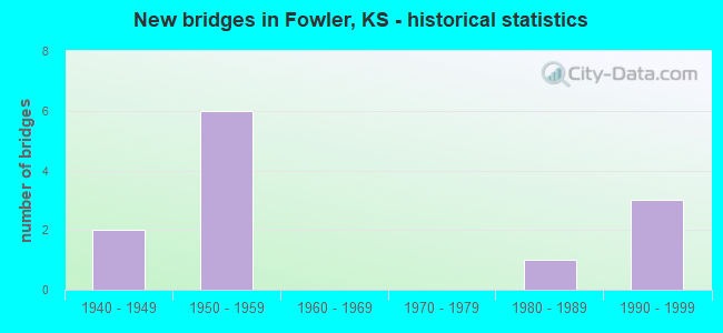
- New bridges - historical statistics
- 21940-1949
- 61950-1959
- 11980-1989
- 31990-1999


- Bridge Condition - Deck
- 37.5%Good
- 50.0%Satisfactory
- 12.5%Fair

- Bridge Condition - Superstructure
- 62.5%Good
- 37.5%Satisfactory

- Bridge Condition - Substructure
- 12.5%Very good
- 62.5%Good
- 12.5%Satisfactory
- 12.5%Fair

- Bridge Condition - Channel
- 58.3%Very good
- 25.0%Good
- 16.7%Satisfactory

- Bridge Condition - Culverts
- 25.0%Very good
- 75.0%Good
Find on map >> Show street view
Structure Number: 60001, Location: 0.3N OF FOWLER (Lat: 37.391500, Lng: -100.198233), Route carried "on" structure: County highway 251, Year Built: 1958, Status: Open, Structure Length: 6.80m (22.31ft), Average Daily Traffic: 195 (year 2018), Truck Traffic: 15%, Average Future Daily Traffic: 234 (year 2040), Design Load: H 15, Features Intersected: CROOKED CREEK OVERFLOW
Minimum Vertical Clearance: 30.47m (99.97ft), Kilometerpoint: 0.000, Lanes on structure: 2, Owner: County Highway Agency, Approaching Roadway Width: 9.8m (32.2ft), Material/Design: Concrete continuous, Design/Construction: Tee Beam, Number Of Spans In Main Unit: 5, Length of Maximum Span: 14.6m (47.9ft), Curb or Sidewalk Widths: Left: 0.3m (1.0ft), Right: 0.3m (1.0ft), Curb-To-Curb Width: 7.3m (24.0ft), Out-to-Out Width: 8.0m (26.2ft)
Condition: Deck: Good, Superstructure: Good, Substructure: Good, Channel: Good, Operating Rating: 35.1 metric tons, Method Used To Determine Operating Rating: No rating analysis performed, Inventory Rating: 24.3 metric tons, Method Used To Determine Inventory Rating: No rating analysis performed, Structural Evaluation: Equal to present minimum criteria, Deck Geometry: Somewhat better than minimum adequacy, Waterway Adequacy: Equal to present desirable criteria, Approach Roadway Alignment: Better than present minimum criteria, Designated Inspection Frequency: Every 24 months, Inspection Date: September 2020, Deck Structure Type: Concrete Cast-file-Place, Wearing Surface/Protective System: Wearing Surface: Bituminous
Find on map >> Show street view
Structure Number: 600501006643, Location: 1.5S 2.0W OF FOWLER (Lat: 37.354194, Lng: -100.236328), Route carried "on" structure: County highway , Year Built: 1991, Status: Open, Structure Length: 6.16m (20.21ft), Average Daily Traffic: 30 (year 2012), Truck Traffic: 10%, Average Future Daily Traffic: 40 (year 2040), Design Load: HS 20, Features Intersected: CROOKED CK. RELIEF CHAN., Facility Carried by Structure: Road 24
Minimum Vertical Clearance: 30.47m (99.97ft), Kilometerpoint: 0.000, Lanes on structure: 2, Owner: County Highway Agency, Approaching Roadway Width: 6.9m (22.6ft), Skew: 4 degrees, Material/Design: Concrete continuous, Design/Construction: Slab, Number Of Spans In Main Unit: 5, Length of Maximum Span: 13.4m (44.0ft), Curb or Sidewalk Widths: Left: 0.3m (1.0ft), Right: 0.3m (1.0ft), Curb-To-Curb Width: 7.9m (25.9ft), Out-to-Out Width: 8.5m (27.9ft)
Condition: Deck: Good, Superstructure: Good, Substructure: Good, Channel: Good, Operating Rating: 56.8 metric tons, Method Used To Determine Operating Rating: Load and Resistance Factor (LRFR), Inventory Rating: 33.9 metric tons, Method Used To Determine Inventory Rating: Load and Resistance Factor (LRFR), Structural Evaluation: Better than present minimum criteria, Deck Geometry: Equal to present minimum criteria, Waterway Adequacy: Equal to present desirable criteria, Approach Roadway Alignment: Better than present minimum criteria, Designated Inspection Frequency: Every 24 months, Inspection Date: September 2020, Deck Structure Type: Concrete Cast-file-Place, Wearing Surface/Protective System: Wearing Surface: Monolithic Concrete
Find on map >> Show street view
Structure Number: 60050190656, Location: 2.2W 2.5N OF FOWLER (Lat: 37.416611, Lng: -100.234672), Route carried "on" structure: County highway , Year Built: 1957, Status: Open, Structure Length: 0.85m (2.79ft), Average Daily Traffic: 80 (year 2012), Truck Traffic: 10%, Average Future Daily Traffic: 96 (year 2040), Design Load: H 15, Features Intersected: DRAW, Facility Carried by Structure: Road E
Minimum Vertical Clearance: 30.47m (99.97ft), Kilometerpoint: 0.000, Lanes on structure: 2, Owner: County Highway Agency, Approaching Roadway Width: 8.5m (27.9ft), Material/Design: Concrete, Design/Construction: Culvert, Number Of Spans In Main Unit: 3, Length of Maximum Span: 2.7m (8.9ft), Curb-To-Curb Width: 8.5m (27.9ft), Out-to-Out Width: 9.1m (29.9ft)
Condition: Channel: Good, Culverts: Good, Operating Rating: 36.3 metric tons, Method Used To Determine Operating Rating: Load Testing, Inventory Rating: 21.8 metric tons, Method Used To Determine Inventory Rating: Load Testing, Structural Evaluation: Equal to present minimum criteria, Deck Geometry: Better than present minimum criteria, Waterway Adequacy: Equal to present minimum criteria, Approach Roadway Alignment: Better than present minimum criteria, Designated Inspection Frequency: Every 24 months, Inspection Date: September 2020, Wearing Surface/Protective System: Wearing Surface: Gravel
Find on map >> Show street view
Structure Number: 60050190662, Location: 1.1W OF FOWLER (Lat: 37.372583, Lng: -100.219556), Route carried "on" structure: County highway , Year Built: 1946, Status: Posted for load, Structure Length: 1.95m (6.40ft), Average Daily Traffic: 40 (year 2012), Truck Traffic: 10%, Average Future Daily Traffic: 48 (year 2040), Features Intersected: CROOKED CREEK, Facility Carried by Structure: Road H
Minimum Vertical Clearance: 30.47m (99.97ft), Kilometerpoint: 0.000, Lanes on structure: 2, Owner: County Highway Agency, Approaching Roadway Width: 6.4m (21.0ft), Material/Design: Wood or Timber, Design/Construction: Stringer/Multi-beam, Number Of Spans In Main Unit: 3, Length of Maximum Span: 6.4m (21.0ft), Curb-To-Curb Width: 6.1m (20.0ft), Out-to-Out Width: 6.3m (20.7ft)
Condition: Deck: Fair, Superstructure: Satisfactory, Substructure: Fair, Channel: Satisfactory, Operating Rating: 26.1 metric tons, Method Used To Determine Operating Rating: Allowable Stress (AS), Inventory Rating: 18.6 metric tons, Method Used To Determine Inventory Rating: Allowable Stress (AS), Structural Evaluation: Somewhat better than minimum adequacy, Deck Geometry: Somewhat better than minimum adequacy, Waterway Adequacy: Better than present minimum criteria, Approach Roadway Alignment: Equal to present minimum criteria, Bridge Posting: Required (Relationship of Operating Rating to Maximum Legal Load: 0.1 - 9.9% below), Designated Inspection Frequency: Every 24 months, Inspection Date: September 2020, Deck Structure Type: Wood or Timber, Wearing Surface/Protective System: Wearing Surface: Gravel
Find on map >> Show street view
Structure Number: 600509006526, Location: 1.0E 3.4N OF FOWLER (Lat: 37.436750, Lng: -100.180350), Route carried "on" structure: County highway , Year Built: 1988, Status: Open, Structure Length: 3.05m (10.01ft), Average Daily Traffic: 40 (year 2012), Truck Traffic: 10%, Average Future Daily Traffic: 48 (year 2040), Features Intersected: CROOKED CREEK, Facility Carried by Structure: Road 27
Minimum Vertical Clearance: 30.47m (99.97ft), Kilometerpoint: 0.000, Lanes on structure: 2, Owner: County Highway Agency, Approaching Roadway Width: 7.3m (24.0ft), Material/Design: Steel continuous, Design/Construction: Stringer/Multi-beam, Number Of Spans In Main Unit: 3, Length of Maximum Span: 11.6m (38.1ft), Curb-To-Curb Width: 8.4m (27.6ft), Out-to-Out Width: 8.5m (27.9ft)
Condition: Deck: Satisfactory, Superstructure: Good, Substructure: Satisfactory, Channel: Satisfactory, Operating Rating: 57.4 metric tons, Method Used To Determine Operating Rating: Load Factor (LF), Inventory Rating: 34.3 metric tons, Method Used To Determine Inventory Rating: Load Factor (LF), Structural Evaluation: Equal to present minimum criteria, Deck Geometry: Equal to present minimum criteria, Waterway Adequacy: Equal to present desirable criteria, Approach Roadway Alignment: Better than present minimum criteria, Designated Inspection Frequency: Every 24 months, Inspection Date: September 2020, Deck Structure Type: Corrugated Steel, Wearing Surface/Protective System: Wearing Surface: Bituminous
Find on map >> Show street view
Structure Number: 999905400600091, Location: 7.26 MI NE EJCT US160 (Lat: 37.358333, Lng: -100.226944), Route carried "on" structure: US 54, Year Built: 1946, Year Reconstructed: 1991, Status: Open, Structure Length: 1.98m (6.50ft), Average Daily Traffic: 4,715 (year 2020), Truck Traffic: 35%, Average Future Daily Traffic: 6,737 (year 2041), Design Load: H 20, Features Intersected: DRY LAKE DRAINAGE
Minimum Vertical Clearance: 30.47m (99.97ft), Kilometerpoint: 41.606, Lanes on structure: 2, Base Highway Network: Yes, Owner: State Highway Agency, Approaching Roadway Width: 13.4m (44.0ft), Material/Design: Concrete, Design/Construction: Culvert, Number Of Spans In Main Unit: 6, Length of Maximum Span: 3.0m (9.8ft), Curb-To-Curb Width: 13.4m (44.0ft), Out-to-Out Width: 14.0m (45.9ft)
Condition: Channel: Very good, Culverts: Good, Operating Rating: 28.9 metric tons, Method Used To Determine Operating Rating: Load Factor (LF), Inventory Rating: 17.3 metric tons, Method Used To Determine Inventory Rating: Load Factor (LF), Structural Evaluation: Meets minimum limits, Deck Geometry: Better than present minimum criteria, Waterway Adequacy: Equal to present desirable criteria, Approach Roadway Alignment: Equal to present desirable criteria, Length Of Structure Improvement: 6.48m (21.26ft), Designated Inspection Frequency: Every 24 months, Inspection Date: August 2020, Deck Structure Type: Concrete Cast-file-Place, Wearing Surface/Protective System: Wearing Surface: Bituminous
Find on map >> Show street view
Structure Number: 999905400600111, Location: 9.23 MI NE EJCT US160 (Lat: 37.373333, Lng: -100.197222), Route carried "on" structure: US 54, Year Built: 1953, Year Reconstructed: 1991, Status: Open, Structure Length: 1.04m (3.41ft), Average Daily Traffic: 4,715 (year 2020), Truck Traffic: 35%, Average Future Daily Traffic: 6,737 (year 2041), Design Load: H 20, Features Intersected: CROOKED CREEK DRAINAGE
Minimum Vertical Clearance: 30.47m (99.97ft), Kilometerpoint: 44.774, Lanes on structure: 2, Base Highway Network: Yes, Owner: State Highway Agency, Approaching Roadway Width: 13.4m (44.0ft), Material/Design: Concrete, Design/Construction: Culvert, Number Of Spans In Main Unit: 4, Length of Maximum Span: 2.4m (7.9ft), Curb-To-Curb Width: 13.4m (44.0ft), Out-to-Out Width: 27.0m (88.6ft)
Condition: Channel: Very good, Culverts: Good, Operating Rating: 31.3 metric tons, Method Used To Determine Operating Rating: Load Factor (LF), Inventory Rating: 18.7 metric tons, Method Used To Determine Inventory Rating: Load Factor (LF), Structural Evaluation: Somewhat better than minimum adequacy, Deck Geometry: Better than present minimum criteria, Waterway Adequacy: Better than present minimum criteria, Approach Roadway Alignment: Meets minimum limits, Length Of Structure Improvement: 3.40m (11.15ft), Designated Inspection Frequency: Every 24 months, Inspection Date: August 2020, Deck Structure Type: Concrete Cast-file-Place, Wearing Surface/Protective System: Wearing Surface: Bituminous
Find on map >> Show street view
Structure Number: 999905400600121, Location: 0.47 MI NE K98 HWY (Lat: 37.378056, Lng: -100.188611), Route carried "on" structure: US 54, Year Built: 1953, Year Reconstructed: 1991, Status: Open, Structure Length: 0.85m (2.79ft), Average Daily Traffic: 4,478 (year 2020), Truck Traffic: 35%, Average Future Daily Traffic: 6,398 (year 2041), Design Load: H 20, Features Intersected: CROOKED CREEK DRAINAGE
Minimum Vertical Clearance: 30.47m (99.97ft), Kilometerpoint: 45.686, Lanes on structure: 2, Base Highway Network: Yes, Owner: State Highway Agency, Approaching Roadway Width: 13.4m (44.0ft), Material/Design: Concrete, Design/Construction: Culvert, Number Of Spans In Main Unit: 3, Length of Maximum Span: 2.7m (8.9ft), Curb-To-Curb Width: 13.4m (44.0ft), Out-to-Out Width: 26.1m (85.6ft)
Condition: Channel: Very good, Culverts: Very good, Operating Rating: 26.2 metric tons, Method Used To Determine Operating Rating: Load Factor (LF), Inventory Rating: 15.7 metric tons, Method Used To Determine Inventory Rating: Load Factor (LF), Structural Evaluation: Meets minimum limits, Deck Geometry: Better than present minimum criteria, Waterway Adequacy: Equal to present desirable criteria, Approach Roadway Alignment: Equal to present desirable criteria, Length Of Structure Improvement: 2.80m (9.19ft), Designated Inspection Frequency: Every 24 months, Inspection Date: August 2020, Deck Structure Type: Concrete Cast-file-Place, Wearing Surface/Protective System: Wearing Surface: Bituminous
Find on map >> Show street view
Structure Number: 999905400600311, Location: 6.13 MI NE EJCT US160 (Lat: 37.348333, Lng: -100.243056), Route carried "on" structure: US 54, Year Built: 1991, Status: Open, Structure Length: 4.65m (15.26ft), Average Daily Traffic: 4,715 (year 2020), Truck Traffic: 35%, Average Future Daily Traffic: 6,737 (year 2041), Design Load: HS 20, Features Intersected: CROOKED CREEK
Minimum Vertical Clearance: 30.47m (99.97ft), Kilometerpoint: 39.781, Lanes on structure: 2, Base Highway Network: Yes, Owner: State Highway Agency, Approaching Roadway Width: 13.4m (44.0ft), Material/Design: Concrete continuous, Design/Construction: Slab, Number Of Spans In Main Unit: 3, Length of Maximum Span: 18.3m (60.0ft), Curb-To-Curb Width: 13.4m (44.0ft), Out-to-Out Width: 14.0m (45.9ft)
Condition: Deck: Good, Superstructure: Good, Substructure: Very good, Channel: Very good, Operating Rating: 73.5 metric tons, Method Used To Determine Operating Rating: Load Factor (LF), Inventory Rating: 44.5 metric tons, Method Used To Determine Inventory Rating: Load Factor (LF), Structural Evaluation: Better than present minimum criteria, Deck Geometry: Better than present minimum criteria, Waterway Adequacy: Equal to present desirable criteria, Approach Roadway Alignment: Equal to present desirable criteria, Length Of Structure Improvement: 15.25m (50.03ft), Designated Inspection Frequency: Every 24 months, Inspection Date: August 2020, Wearing Surface/Protective System: Wearing Surface: Monolithic Concrete, Deck Protection: Epoxy Coated Reinforcing
Find on map >> Show street view
Structure Number: 999905400600321, Location: 7.68 MI NE EJCT US160 (Lat: 37.362222, Lng: -100.220833), Route carried "on" structure: US 54, Year Built: 1991, Status: Open, Structure Length: 3.12m (10.24ft), Average Daily Traffic: 4,715 (year 2020), Truck Traffic: 35%, Average Future Daily Traffic: 6,737 (year 2041), Design Load: HS 20, Features Intersected: CROOKED CREEK
Minimum Vertical Clearance: 30.47m (99.97ft), Kilometerpoint: 42.287, Lanes on structure: 2, Base Highway Network: Yes, Owner: State Highway Agency, Approaching Roadway Width: 13.4m (44.0ft), Material/Design: Concrete continuous, Design/Construction: Slab, Number Of Spans In Main Unit: 3, Length of Maximum Span: 12.2m (40.0ft), Curb-To-Curb Width: 13.4m (44.0ft), Out-to-Out Width: 14.0m (45.9ft)
Condition: Deck: Satisfactory, Superstructure: Good, Substructure: Good, Channel: Very good, Operating Rating: 74.4 metric tons, Method Used To Determine Operating Rating: Load Factor (LF), Inventory Rating: 44.5 metric tons, Method Used To Determine Inventory Rating: Load Factor (LF), Structural Evaluation: Better than present minimum criteria, Deck Geometry: Better than present minimum criteria, Waterway Adequacy: Equal to present desirable criteria, Approach Roadway Alignment: Equal to present desirable criteria, Length Of Structure Improvement: 10.25m (33.63ft), Designated Inspection Frequency: Every 24 months, Inspection Date: August 2020, Wearing Surface/Protective System: Wearing Surface: Monolithic Concrete, Deck Protection: Epoxy Coated Reinforcing
Find on map >> Show street view
Structure Number: 999909800600291, Location: 7.24 MI E K23 (Lat: 37.386944, Lng: -100.211944), Route carried "on" structure: State highway 98, Year Built: 1957, Status: Open, Structure Length: 3.25m (10.66ft), Average Daily Traffic: 284 (year 2020), Truck Traffic: 11%, Average Future Daily Traffic: 347 (year 2041), Design Load: H 20, Features Intersected: CROOKED CREEK
Minimum Vertical Clearance: 30.47m (99.97ft), Kilometerpoint: 11.629, Lanes on structure: 2, Owner: State Highway Agency, Approaching Roadway Width: 7.3m (24.0ft), Material/Design: Concrete continuous, Design/Construction: Slab, Number Of Spans In Main Unit: 3, Length of Maximum Span: 12.2m (40.0ft), Curb-To-Curb Width: 7.9m (25.9ft), Out-to-Out Width: 9.5m (31.2ft)
Condition: Deck: Satisfactory, Superstructure: Satisfactory, Substructure: Good, Channel: Very good, Operating Rating: 52.7 metric tons, Method Used To Determine Operating Rating: Load Factor (LF), Inventory Rating: 31.6 metric tons, Method Used To Determine Inventory Rating: Load Factor (LF), Structural Evaluation: Equal to present minimum criteria, Deck Geometry: Somewhat better than minimum adequacy, Waterway Adequacy: Better than present minimum criteria, Approach Roadway Alignment: Better than present minimum criteria, Length Of Structure Improvement: 10.65m (34.94ft), Designated Inspection Frequency: Every 24 months, Inspection Date: August 2020, Deck Structure Type: Concrete Cast-file-Place, Wearing Surface/Protective System: Wearing Surface: Low Slump Concrete
Find on map >> Show street view
Structure Number: 999909800600301, Location: 7.65 MI E K23 (Lat: 37.386944, Lng: -100.204722), Route carried "on" structure: State highway 98, Year Built: 1957, Status: Open, Structure Length: 6.90m (22.64ft), Average Daily Traffic: 284 (year 2020), Truck Traffic: 11%, Average Future Daily Traffic: 347 (year 2041), Design Load: H 20, Features Intersected: CROOKED CREEK OVERFLOW
Minimum Vertical Clearance: 30.47m (99.97ft), Kilometerpoint: 12.295, Lanes on structure: 2, Owner: State Highway Agency, Approaching Roadway Width: 7.3m (24.0ft), Material/Design: Concrete continuous, Design/Construction: Slab, Number Of Spans In Main Unit: 6, Length of Maximum Span: 12.2m (40.0ft), Curb-To-Curb Width: 7.9m (25.9ft), Out-to-Out Width: 9.5m (31.2ft)
Condition: Deck: Satisfactory, Superstructure: Satisfactory, Substructure: Good, Channel: Very good, Operating Rating: 49.8 metric tons, Method Used To Determine Operating Rating: Load Factor (LF), Inventory Rating: 29.8 metric tons, Method Used To Determine Inventory Rating: Load Factor (LF), Structural Evaluation: Equal to present minimum criteria, Deck Geometry: Somewhat better than minimum adequacy, Waterway Adequacy: Better than present minimum criteria, Approach Roadway Alignment: Better than present minimum criteria, Length Of Structure Improvement: 22.65m (74.31ft), Designated Inspection Frequency: Every 24 months, Inspection Date: August 2020, Deck Structure Type: Concrete Cast-file-Place, Wearing Surface/Protective System: Wearing Surface: Low Slump Concrete