Bridge Statistics for Fowlerton, Indiana (IN)
Condition, Traffic, Stress, Structural Evaluation, Project Costs
- National Bridge Inventory (NBI) Statistics
- 15Number of bridges
- 105ft / 31.8mTotal length
- $443,000Total costs
- 141,789Total average daily traffic
- 23,473Total average daily truck traffic
- National Bridge Inventory (NBI) Registered Bridges for Fowlerton
- No street view available for this location
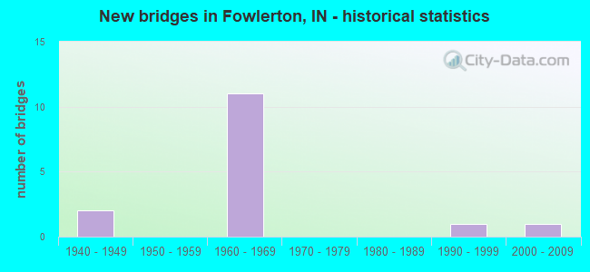
- New bridges - historical statistics
- 21940-1949
- 111960-1969
- 11990-1999
- 12000-2009


- Bridge Condition - Deck
- 22.2%Good
- 44.4%Satisfactory
- 33.3%Fair

- Bridge Condition - Superstructure
- 11.1%Very good
- 33.3%Good
- 55.6%Satisfactory

- Bridge Condition - Substructure
- 22.2%Very good
- 11.1%Good
- 55.6%Satisfactory
- 11.1%Fair

- Bridge Condition - Channel
- 14.3%Very good
- 28.6%Good
- 42.9%Satisfactory
- 14.3%Fair

- Bridge Condition - Culverts
- 50.0%Satisfactory
- 50.0%Fair
Find on map >> Show street view
Structure Number: 693, Location: 05.01 W SR 22 (Lat: 40.422889, Lng: -85.549450), Route carried "on" structure: State highway 26, Year Built: 1963, Year Reconstructed: 1997, Status: Open, Structure Length: 6.49m (21.29ft), Average Daily Traffic: 4,133 (year 2018), Truck Traffic: 13%, Average Future Daily Traffic: 5,973 (year 2032), Design Load: HS 20, Features Intersected: I-69 NB/SB
Minimum Vertical Clearance: 30+ m (98+ ft), Kilometerpoint: 26.522, Lanes on structure: 2, Lanes under structure: 4, Owner: State Highway Agency, Approaching Roadway Width: 10.1m (33.1ft), Material/Design: Concrete continuous, Design/Construction: Stringer/Multi-beam, Number Of Spans In Main Unit: 4, Length of Maximum Span: 20.0m (65.6ft), Curb-To-Curb Width: 10.2m (33.5ft), Out-to-Out Width: 11.1m (36.4ft)
Condition: Deck: Fair, Superstructure: Satisfactory, Substructure: Fair, Operating Rating: 64.7 metric tons, Method Used To Determine Operating Rating: Load Factor (LF), Inventory Rating: 38.8 metric tons, Method Used To Determine Inventory Rating: Load Factor (LF), Structural Evaluation: Somewhat better than minimum adequacy, Deck Geometry: Meets minimum limits, Underclear: Meets minimum limits, Approach Roadway Alignment: Equal to present desirable criteria, Designated Inspection Frequency: Every 24 months, Inspection Date: December 2021, Deck Structure Type: Concrete Cast-file-Place, Wearing Surface/Protective System: Wearing Surface: Latex Concrete
Find on map >> Show street view
Structure Number: 3954, Location: 06.04 N SR 28 (Lat: 40.364439, Lng: -85.558881), Route carried "on" structure: Alternate County highway , Year Built: 1963, Status: Open, Structure Length: 6.54m (21.46ft), Average Daily Traffic: 143 (year 2004), Truck Traffic: 10%, Average Future Daily Traffic: 237 (year 2032), Design Load: HS 20, Features Intersected: I-69, Facility Carried by Structure: CR 1200 N
Minimum Vertical Clearance: 30+ m (98+ ft), Kilometerpoint: 0.000, Lanes on structure: 2, Lanes under structure: 4, Owner: State Highway Agency, Approaching Roadway Width: 6.7m (22.0ft), Material/Design: Concrete continuous, Design/Construction: Stringer/Multi-beam, Number Of Spans In Main Unit: 4, Length of Maximum Span: 20.1m (65.9ft), Curb or Sidewalk Widths: Left: 0.5m (1.6ft), Right: 0.5m (1.6ft), Curb-To-Curb Width: 7.3m (24.0ft), Out-to-Out Width: 9.0m (29.5ft)
Condition: Deck: Satisfactory, Superstructure: Satisfactory, Substructure: Satisfactory, Operating Rating: 56.3 metric tons, Method Used To Determine Operating Rating: Load Factor (LF), Inventory Rating: 33.7 metric tons, Method Used To Determine Inventory Rating: Load Factor (LF), Structural Evaluation: Equal to present minimum criteria, Deck Geometry: Somewhat better than minimum adequacy, Underclear: Meets minimum limits, Approach Roadway Alignment: Equal to present desirable criteria, Length Of Structure Improvement: 6.55m (21.49ft), Designated Inspection Frequency: Every 24 months, Inspection Date: August 2021, Bridge Improvement Cost: $443,000, Total Project Cost: $443,000, Deck Structure Type: Concrete Cast-file-Place, Wearing Surface/Protective System: Wearing Surface: Epoxy Overlay
Find on map >> Show street view
Structure Number: 3955, Location: 03.16 S SR 26 (Lat: 40.378619, Lng: -85.553661), Route carried "on" structure: Interstate 69, Year Built: 1963, Year Reconstructed: 1995, Status: Open, Structure Length: 4.79m (15.72ft), Average Daily Traffic: 12,024 (year 2004), Truck Traffic: 10%, Average Future Daily Traffic: 21,776 (year 2029), Design Load: HS 20+Mod, Features Intersected: ABANDONED RR
Minimum Vertical Clearance: 30+ m (98+ ft), Kilometerpoint: 405.201, Lanes on structure: 2, Base Highway Network: Yes (, Subroute: 1), Owner: State Highway Agency, Approaching Roadway Width: 11.6m (38.1ft), Skew: 2 degrees, Material/Design: Steel continuous, Design/Construction: Stringer/Multi-beam, Number Of Spans In Main Unit: 3, Length of Maximum Span: 17.5m (57.4ft), Curb-To-Curb Width: 12.0m (39.4ft), Out-to-Out Width: 13.0m (42.7ft)
Condition: Deck: Fair, Superstructure: Satisfactory, Substructure: Satisfactory, Operating Rating: 60.3 metric tons, Method Used To Determine Operating Rating: Load and Resistance Factor Rating (LRFR) rating reported by rating factor(RF) method using HL-93 loadings, Inventory Rating: 46.3 metric tons, Method Used To Determine Inventory Rating: Load and Resistance Factor Rating (LRFR) rating reported by rating factor(RF) method using HL-93 loadings, Structural Evaluation: Equal to present minimum criteria, Deck Geometry: Equal to present minimum criteria, Approach Roadway Alignment: Equal to present desirable criteria, Designated Inspection Frequency: Every 24 months, Inspection Date: August 2021, Deck Structure Type: Concrete Cast-file-Place, Wearing Surface/Protective System: Wearing Surface: Monolithic Concrete, Deck Protection: Epoxy Coated Reinforcing
Find on map >> Show street view
Structure Number: 3956, Location: 03.16 S SR 26 (Lat: 40.378819, Lng: -85.553831), Route carried "on" structure: Interstate 69, Year Built: 1963, Year Reconstructed: 1995, Status: Open, Structure Length: 4.79m (15.72ft), Average Daily Traffic: 12,024 (year 2004), Truck Traffic: 10%, Average Future Daily Traffic: 21,776 (year 2029), Design Load: HS 20+Mod, Features Intersected: ABANDONED RR
Minimum Vertical Clearance: 30+ m (98+ ft), Kilometerpoint: 405.201, Lanes on structure: 2, Base Highway Network: Yes (, Subroute: 1), Owner: State Highway Agency, Approaching Roadway Width: 11.6m (38.1ft), Skew: 2 degrees, Material/Design: Steel continuous, Design/Construction: Stringer/Multi-beam, Number Of Spans In Main Unit: 3, Length of Maximum Span: 17.5m (57.4ft), Curb-To-Curb Width: 12.0m (39.4ft), Out-to-Out Width: 13.0m (42.7ft)
Condition: Deck: Fair, Superstructure: Satisfactory, Substructure: Satisfactory, Operating Rating: 60.3 metric tons, Method Used To Determine Operating Rating: Load and Resistance Factor Rating (LRFR) rating reported by rating factor(RF) method using HL-93 loadings, Inventory Rating: 46.3 metric tons, Method Used To Determine Inventory Rating: Load and Resistance Factor Rating (LRFR) rating reported by rating factor(RF) method using HL-93 loadings, Structural Evaluation: Equal to present minimum criteria, Deck Geometry: Equal to present minimum criteria, Approach Roadway Alignment: Equal to present desirable criteria, Designated Inspection Frequency: Every 24 months, Inspection Date: August 2021, Deck Structure Type: Concrete Cast-file-Place, Wearing Surface/Protective System: Wearing Surface: Monolithic Concrete, Deck Protection: Epoxy Coated Reinforcing
Find on map >> Show street view
Structure Number: 2700104, Location: 00.51 MI N of SR 26 (Lat: 40.430769, Lng: -85.578300), Route carried "on" structure: County highway 43, Year Built: 1960, Status: Open, Structure Length: 2.06m (6.76ft), Average Daily Traffic: 790 (year 2021), Truck Traffic: 5%, Average Future Daily Traffic: 1,210 (year 2041), Design Load: HS 20, Features Intersected: BARREN CREEK, Facility Carried by Structure: CR 500E
Minimum Vertical Clearance: 30+ m (98+ ft), Kilometerpoint: 0.000, Lanes on structure: 2, Owner: County Highway Agency, Approaching Roadway Width: 6.1m (20.0ft), Material/Design: Concrete continuous, Design/Construction: Slab, Number Of Spans In Main Unit: 3, Length of Maximum Span: 7.4m (24.3ft), Curb or Sidewalk Widths: Left: 0.3m (1.0ft), Right: 0.3m (1.0ft), Curb-To-Curb Width: 6.2m (20.3ft), Out-to-Out Width: 7.4m (24.3ft)
Condition: Deck: Satisfactory, Superstructure: Good, Substructure: Satisfactory, Channel: Satisfactory, Operating Rating: 85.5 metric tons, Method Used To Determine Operating Rating: Load Factor (LF), Inventory Rating: 66.0 metric tons, Method Used To Determine Inventory Rating: Load Factor (LF), Structural Evaluation: Equal to present minimum criteria, Deck Geometry: High priority of corrective action, Waterway Adequacy: Better than present minimum criteria, Approach Roadway Alignment: Equal to present desirable criteria, Designated Inspection Frequency: Every 24 months, Inspection Date: October 2021, Deck Structure Type: Concrete Cast-file-Place, Wearing Surface/Protective System: Wearing Surface: Bituminous
Find on map >> Show street view
Structure Number: 2700106, Location: 00.08 MI N of SR 26 (Lat: 40.424539, Lng: -85.587839), Route carried "on" structure: County highway 155, Year Built: 2002, Status: Open, Structure Length: 1.77m (5.81ft), Average Daily Traffic: 180 (year 2021), Truck Traffic: 5%, Average Future Daily Traffic: 280 (year 2041), Design Load: HS 20, Features Intersected: BARREN CREEK, Facility Carried by Structure: CR 450E
Minimum Vertical Clearance: 30+ m (98+ ft), Kilometerpoint: 0.000, Lanes on structure: 2, Owner: County Highway Agency, Approaching Roadway Width: 5.2m (17.1ft), Skew: 3 degrees, Material/Design: Prestressed concrete, Design/Construction: Box Beam or Girders - Multiple, Number Of Spans In Main Unit: 1, Length of Maximum Span: 17.1m (56.1ft), Curb-To-Curb Width: 7.3m (24.0ft), Out-to-Out Width: 7.4m (24.3ft)
Condition: Deck: Satisfactory, Superstructure: Very good, Substructure: Very good, Channel: Very good, Operating Rating: 40.9 metric tons, Method Used To Determine Operating Rating: Load Factor (LF), Inventory Rating: 31.5 metric tons, Method Used To Determine Inventory Rating: Load Factor (LF), Structural Evaluation: Better than present minimum criteria, Deck Geometry: Somewhat better than minimum adequacy, Waterway Adequacy: Better than present minimum criteria, Approach Roadway Alignment: Equal to present desirable criteria, Designated Inspection Frequency: Every 24 months, Inspection Date: October 2021, Deck Structure Type: Concrete Cast-file-Place, Wearing Surface/Protective System: Wearing Surface: Monolithic Concrete
Find on map >> Show street view
Structure Number: 2700109, Location: 01.16 MI S of SR 26 (Lat: 40.406589, Lng: -85.606761), Route carried "on" structure: County highway 39, Year Built: 1960, Status: Open, Structure Length: 1.60m (5.25ft), Average Daily Traffic: 210 (year 2021), Truck Traffic: 5%, Average Future Daily Traffic: 320 (year 2041), Features Intersected: BARREN CREEK, Facility Carried by Structure: CR 350E
Minimum Vertical Clearance: 30+ m (98+ ft), Kilometerpoint: 0.000, Lanes on structure: 2, Owner: County Highway Agency, Approaching Roadway Width: 5.5m (18.0ft), Skew: 2 degrees, Material/Design: Steel continuous, Design/Construction: Stringer/Multi-beam, Number Of Spans In Main Unit: 3, Length of Maximum Span: 5.3m (17.4ft), Curb or Sidewalk Widths: Left: 0.2m (0.7ft), Right: 0.2m (0.7ft), Curb-To-Curb Width: 6.3m (20.7ft), Out-to-Out Width: 7.4m (24.3ft)
Condition: Deck: Satisfactory, Superstructure: Satisfactory, Substructure: Satisfactory, Channel: Good, Operating Rating: 37.6 metric tons, Method Used To Determine Operating Rating: Field evaluation and documented engineering judgment, Inventory Rating: 29.0 metric tons, Method Used To Determine Inventory Rating: Field evaluation and documented engineering judgment, Structural Evaluation: Equal to present minimum criteria, Deck Geometry: Meets minimum limits, Waterway Adequacy: Better than present minimum criteria, Approach Roadway Alignment: Equal to present minimum criteria, Designated Inspection Frequency: Every 24 months, Inspection Date: October 2021, Deck Structure Type: Concrete Cast-file-Place, Wearing Surface/Protective System: Wearing Surface: Bituminous
Find on map >> Show street view
Structure Number: 2700114, Location: 00.09 MI S of WHEELING PI (Lat: 40.435519, Lng: -85.550419), Route carried "on" structure: County highway 171, Year Built: 1940, Status: Open, Structure Length: 0.74m (2.43ft), Average Daily Traffic: 110 (year 2021), Truck Traffic: 5%, Average Future Daily Traffic: 170 (year 2041), Features Intersected: BARREN CREEK, Facility Carried by Structure: CR 650E
Minimum Vertical Clearance: 30+ m (98+ ft), Kilometerpoint: 0.000, Lanes on structure: 2, Owner: County Highway Agency, Approaching Roadway Width: 4.6m (15.1ft), Material/Design: Concrete, Design/Construction: Culvert, Number Of Spans In Main Unit: 1, Length of Maximum Span: 6.7m (22.0ft), Curb-To-Curb Width: 6.9m (22.6ft), Out-to-Out Width: 7.5m (24.6ft)
Condition: Channel: Satisfactory, Culverts: Fair, Operating Rating: 42.3 metric tons, Method Used To Determine Operating Rating: Field evaluation and documented engineering judgment, Inventory Rating: 32.7 metric tons, Method Used To Determine Inventory Rating: Field evaluation and documented engineering judgment, Structural Evaluation: Somewhat better than minimum adequacy, Deck Geometry: Meets minimum limits, Waterway Adequacy: Better than present minimum criteria, Approach Roadway Alignment: Equal to present minimum criteria, Designated Inspection Frequency: Every 24 months, Inspection Date: October 2021, Wearing Surface/Protective System: Wearing Surface: Bituminous
Find on map >> Show street view
Structure Number: 2700137, Location: 01.99 S SR 26 (Lat: 40.393989, Lng: -85.559431), Route carried "on" structure: County highway 53, Year Built: 1962, Year Reconstructed: 2002, Status: Open, Structure Length: 0.91m (2.99ft), Average Daily Traffic: 160 (year 2021), Truck Traffic: 5%, Average Future Daily Traffic: 240 (year 2041), Features Intersected: FOWLER DITCH, Facility Carried by Structure: CR 600E
Minimum Vertical Clearance: 30+ m (98+ ft), Kilometerpoint: 0.000, Lanes on structure: 2, Owner: County Highway Agency, Approaching Roadway Width: 5.2m (17.1ft), Material/Design: Prestressed concrete, Design/Construction: Box Beam or Girders - Multiple, Number Of Spans In Main Unit: 1, Length of Maximum Span: 8.4m (27.6ft), Curb-To-Curb Width: 7.2m (23.6ft), Out-to-Out Width: 7.4m (24.3ft)
Condition: Deck: Good, Superstructure: Good, Substructure: Very good, Channel: Good, Operating Rating: 42.3 metric tons, Method Used To Determine Operating Rating: Field evaluation and documented engineering judgment, Inventory Rating: 32.7 metric tons, Method Used To Determine Inventory Rating: Field evaluation and documented engineering judgment, Structural Evaluation: Better than present minimum criteria, Deck Geometry: Meets minimum limits, Waterway Adequacy: Better than present minimum criteria, Approach Roadway Alignment: Equal to present desirable criteria, Designated Inspection Frequency: Every 24 months, Inspection Date: October 2021, Deck Structure Type: Concrete Precast Panels, Wearing Surface/Protective System: Wearing Surface: Monolithic Concrete
Find on map >> Show street view
Structure Number: 2700175, Location: 00.47 MI E of CR 350 E (Lat: 40.416139, Lng: -85.597869), Route carried "on" structure: County highway 20, Year Built: 1990, Status: Open, Structure Length: 0.91m (2.99ft), Average Daily Traffic: 450 (year 2021), Truck Traffic: 5%, Average Future Daily Traffic: 690 (year 2041), Design Load: HS 20, Features Intersected: BARREN CREEK, Facility Carried by Structure: CR 950S
Minimum Vertical Clearance: 30+ m (98+ ft), Kilometerpoint: 0.000, Lanes on structure: 2, Owner: County Highway Agency, Approaching Roadway Width: 5.8m (19.0ft), Skew: 2 degrees, Material/Design: Wood or Timber, Design/Construction: Slab, Number Of Spans In Main Unit: 1, Length of Maximum Span: 8.4m (27.6ft), Curb or Sidewalk Widths: Left: 0.2m (0.7ft), Right: 0.2m (0.7ft), Curb-To-Curb Width: 7.5m (24.6ft), Out-to-Out Width: 7.9m (25.9ft)
Condition: Deck: Good, Superstructure: Good, Substructure: Good, Channel: Fair, Operating Rating: 48.6 metric tons, Method Used To Determine Operating Rating: Load and Resistance Factor Rating (LRFR) rating reported by rating factor(RF) method using HL-93 loadings, Inventory Rating: 37.6 metric tons, Method Used To Determine Inventory Rating: Load and Resistance Factor Rating (LRFR) rating reported by rating factor(RF) method using HL-93 loadings, Structural Evaluation: Better than present minimum criteria, Deck Geometry: Meets minimum limits, Waterway Adequacy: Better than present minimum criteria, Approach Roadway Alignment: Equal to present desirable criteria, Designated Inspection Frequency: Every 24 months, Inspection Date: October 2021, Deck Structure Type: Wood or Timber, Wearing Surface/Protective System: Wearing Surface: Bituminous, Deck Protection: Internally Sealed
Find on map >> Show street view
Structure Number: 2700176, Location: 01.70 NW SR 26 (Lat: 40.435700, Lng: -85.549031), Route carried "on" structure: County highway , Year Built: 1940, Status: Open, Structure Length: 1.17m (3.84ft), Average Daily Traffic: 57,630 (year 2021), Truck Traffic: 10%, Average Future Daily Traffic: 88,060 (year 2041), Features Intersected: BARREN CREEK, Facility Carried by Structure: WHEELING PIKE
Minimum Vertical Clearance: 30+ m (98+ ft), Kilometerpoint: 0.000, Lanes on structure: 2, Owner: County Highway Agency, Approaching Roadway Width: 5.8m (19.0ft), Material/Design: Concrete, Design/Construction: Culvert, Number Of Spans In Main Unit: 1, Length of Maximum Span: 11.0m (36.1ft), Curb-To-Curb Width: 9.9m (32.5ft), Out-to-Out Width: 10.7m (35.1ft)
Condition: Channel: Satisfactory, Culverts: Satisfactory, Operating Rating: 34.1 metric tons, Method Used To Determine Operating Rating: Field evaluation and documented engineering judgment, Inventory Rating: 26.3 metric tons, Method Used To Determine Inventory Rating: Field evaluation and documented engineering judgment, Structural Evaluation: Equal to present minimum criteria, Deck Geometry: Meets minimum limits, Waterway Adequacy: Equal to present minimum criteria, Approach Roadway Alignment: Equal to present minimum criteria, Designated Inspection Frequency: Every 24 months, Inspection Date: October 2021
Find on map >> Show street view
Structure Number: 693, Location: 05.01 W SR 22 (Lat: 40.422931, Lng: -85.549478), Route carried "under" structure: Interstate 69, Year Built: 1963, Structure Length: 0. m, Average Daily Traffic: 14,943 (year 2019), Truck Traffic: 37%, Features Intersected: SR 26
Minimum Vertical Clearance: 5.08m (16.67ft), Kilometerpoint: 88.417, Lanes on structure: 2, Lanes under structure: 4, Material/Design: Concrete continuous, Design/Construction: Stringer/Multi-beam, Length of Maximum Span: 20.0m (65.6ft)
Find on map >> Show street view
Structure Number: 693, Location: 05.01 W SR 22 (Lat: 40.422931, Lng: -85.549478), Route carried "under" structure: Interstate 69, Year Built: 1963, Structure Length: 0. m, Average Daily Traffic: 14,943 (year 2019), Truck Traffic: 37%, Features Intersected: SR 26
Minimum Vertical Clearance: 5.11m (16.77ft), Kilometerpoint: 88.417, Lanes on structure: 2, Lanes under structure: 4, Material/Design: Concrete continuous, Design/Construction: Stringer/Multi-beam, Length of Maximum Span: 20.0m (65.6ft)
Find on map >> Show street view
Structure Number: 3954, Location: 06.04 N SR 28 (Lat: 40.364439, Lng: -85.558881), Route carried "under" structure: Interstate 69, Year Built: 1963, Structure Length: 0. m, Average Daily Traffic: 12,024 (year 2004), Truck Traffic: 15%, Features Intersected: I-69 NBL, Facility Carried by Structure: CR 1200N
Minimum Vertical Clearance: 5.33m (17.49ft), Kilometerpoint: 403.543, Lanes on structure: 2, Lanes under structure: 4, Material/Design: Concrete continuous, Design/Construction: Stringer/Multi-beam, Length of Maximum Span: 20.1m (65.9ft)
Find on map >> Show street view
Structure Number: 3954, Location: 06.04 N SR 28 (Lat: 40.364439, Lng: -85.558881), Route carried "under" structure: Interstate 69, Year Built: 1963, Structure Length: 0. m, Average Daily Traffic: 12,025 (year 2004), Truck Traffic: 15%, Features Intersected: I-69 SBL, Facility Carried by Structure: CR 1200N
Minimum Vertical Clearance: 5.31m (17.42ft), Kilometerpoint: 403.543, Lanes on structure: 2, Lanes under structure: 4, Material/Design: Concrete continuous, Design/Construction: Stringer/Multi-beam, Length of Maximum Span: 20.1m (65.9ft)