Bridge Statistics for Frankford, Missouri (MO)
Condition, Traffic, Stress, Structural Evaluation, Project Costs
- National Bridge Inventory (NBI) Statistics
- 23Number of bridges
- 335ft / 102mTotal length
- $2,867,000Total costs
- 55,355Total average daily traffic
- 17,637Total average daily truck traffic
- National Bridge Inventory (NBI) Registered Bridges for Frankford
- No street view available for this location
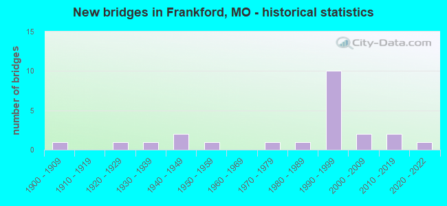
- New bridges - historical statistics
- 11900-1909
- 11920-1929
- 11930-1939
- 21940-1949
- 11950-1959
- 11970-1979
- 11980-1989
- 101990-1999
- 22000-2009
- 22010-2019
- 12020-2022

- Reconstructed bridges - Historical Statistics
- 11950-1959
- 01960-1969
- 01970-1979
- 01980-1989
- 11990-1999
- 02000-2009
- 12010-2019


- Bridge Condition - Deck
- 12.5%Excellent
- 37.5%Very good
- 31.3%Good
- 6.3%Fair
- 12.5%Serious

- Bridge Condition - Superstructure
- 6.3%Excellent
- 6.3%Very good
- 56.3%Good
- 12.5%Satisfactory
- 6.3%Fair
- 12.5%Poor

- Bridge Condition - Substructure
- 31.3%Excellent
- 37.5%Good
- 25.0%Satisfactory
- 6.3%Fair

- Bridge Condition - Channel
- 21.1%Very good
- 57.9%Satisfactory
- 21.1%Fair

- Bridge Condition - Culverts
- 20.0%Good
- 40.0%Satisfactory
- 40.0%Fair
Find on map >> Show street view
Structure Number: 10164, Location: S 14 T 53 N R 3 W (Lat: 39.480450, Lng: -91.305675), Route carried "on" structure: US 61, Year Built: 1995, Status: Open, Structure Length: 10.78m (35.37ft), Average Daily Traffic: 5,405 (year 2021), Truck Traffic: 34%, Average Future Daily Traffic: 10,270 (year 2041), Design Load: HS 25 or greater, Features Intersected: PENO CR
Minimum Vertical Clearance: 30+ m (98+ ft), Kilometerpoint: 506.302, Lanes on structure: 2, Base Highway Network: Yes, Owner: State Highway Agency, Approaching Roadway Width: 12.8m (42.0ft), Skew: 3 degrees, Material/Design: Prestressed concrete continuous, Design/Construction: Tee Beam, Number Of Spans In Main Unit: 4, Length of Maximum Span: 29.3m (96.1ft), Curb or Sidewalk Widths: Left: 0.2m (0.7ft), Right: 0.2m (0.7ft), Curb-To-Curb Width: 11.8m (38.7ft), Out-to-Out Width: 12.6m (41.3ft)
Condition: Deck: Good, Superstructure: Very good, Substructure: Good, Channel: Very good, Operating Rating: 82.8 metric tons, Method Used To Determine Operating Rating: Load Factor (LF), Inventory Rating: 49.5 metric tons, Method Used To Determine Inventory Rating: Load Factor (LF), Structural Evaluation: Better than present minimum criteria, Deck Geometry: Better than present minimum criteria, Waterway Adequacy: Equal to present desirable criteria, Approach Roadway Alignment: Equal to present desirable criteria, Designated Inspection Frequency: Every 24 months, Inspection Date: December 2020, Deck Structure Type: Concrete Cast-file-Place, Wearing Surface/Protective System: Wearing Surface: Monolithic Concrete, Deck Protection: Epoxy Coated Reinforcing
Find on map >> Show street view
Structure Number: 1222, Location: S 5 T 54 N R 4 W (Lat: 39.492806, Lng: -91.387306), Route carried "on" structure: County highway 3, Year Built: 1997, Status: Open, Structure Length: 2.04m (6.69ft), Average Daily Traffic: 35 (year 2021), Truck Traffic: 10%, Average Future Daily Traffic: 44 (year 2041), Features Intersected: CROOKED CR, Facility Carried by Structure: COUNTY RD 005
Minimum Vertical Clearance: 30+ m (98+ ft), Kilometerpoint: 0.483, Lanes on structure: 2, Owner: County Highway Agency, Approaching Roadway Width: 6.7m (22.0ft), Material/Design: Steel, Design/Construction: Stringer/Multi-beam, Number Of Spans In Main Unit: 1, Length of Maximum Span: 19.8m (65.0ft), Curb-To-Curb Width: 6.6m (21.7ft), Out-to-Out Width: 6.7m (22.0ft)
Condition: Deck: Good, Superstructure: Satisfactory, Substructure: Satisfactory, Channel: Satisfactory, Operating Rating: 27.0 metric tons, Method Used To Determine Operating Rating: Load Factor (LF), Inventory Rating: 16.2 metric tons, Method Used To Determine Inventory Rating: Load Factor (LF), Structural Evaluation: Somewhat better than minimum adequacy, Deck Geometry: Somewhat better than minimum adequacy, Waterway Adequacy: Equal to present minimum criteria, Approach Roadway Alignment: Equal to present minimum criteria, Designated Inspection Frequency: Every 24 months, Inspection Date: July 2020, Deck Structure Type: Concrete Cast-file-Place
Find on map >> Show street view
Structure Number: 1249, Location: S 30 T 55 N R 3 W (Lat: 39.517000, Lng: -91.273000), Route carried "on" structure: County highway 11, Year Built: 1979, Year Reconstructed: 2016, Status: Open, Structure Length: 0.64m (2.10ft), Average Daily Traffic: 50 (year 2021), Truck Traffic: 10%, Average Future Daily Traffic: 63 (year 2041), Features Intersected: CREEK, Facility Carried by Structure: COUNTY RD 107
Minimum Vertical Clearance: 30+ m (98+ ft), Kilometerpoint: 2.575, Lanes on structure: 2, Owner: County Highway Agency, Approaching Roadway Width: 7.3m (24.0ft), Material/Design: Steel, Design/Construction: Culvert, Number Of Spans In Main Unit: 2, Length of Maximum Span: 3.0m (9.8ft)
Condition: Channel: Very good, Culverts: Good, Operating Rating: 49.5 metric tons, Method Used To Determine Operating Rating: Allowable Stress (AS), Inventory Rating: 22.5 metric tons, Method Used To Determine Inventory Rating: Allowable Stress (AS), Structural Evaluation: Equal to present minimum criteria, Waterway Adequacy: Equal to present minimum criteria, Approach Roadway Alignment: Equal to present desirable criteria, Designated Inspection Frequency: Every 24 months, Inspection Date: July 2020
Find on map >> Show street view
Structure Number: 13112, Location: S 11 T 54 N R 4 W (Lat: 39.472583, Lng: -91.315722), Route carried "on" structure: County highway 29, Year Built: 1900, Status: Posted for load, Structure Length: 1.98m (6.50ft), Average Daily Traffic: 60 (year 2021), Truck Traffic: 10%, Average Future Daily Traffic: 75 (year 2041), Features Intersected: LIT PENO CR, Facility Carried by Structure: COUNTY RD 049
Minimum Vertical Clearance: 30+ m (98+ ft), Kilometerpoint: 2.414, Lanes on structure: 2, Owner: County Highway Agency, Approaching Roadway Width: 7.3m (24.0ft), Material/Design: Concrete, Design/Construction: Culvert, Number Of Spans In Main Unit: 3, Length of Maximum Span: 4.9m (16.1ft), Curb-To-Curb Width: 15.8m (51.8ft), Out-to-Out Width: 17.1m (56.1ft)
Condition: Channel: Fair, Culverts: Fair, Operating Rating: 10.8 metric tons, Method Used To Determine Operating Rating: Allowable Stress (AS), Inventory Rating: 8.1 metric tons, Method Used To Determine Inventory Rating: Allowable Stress (AS), Structural Evaluation: High priority of replacement, Deck Geometry: Superior to present desirable criteria, Waterway Adequacy: Somewhat better than minimum adequacy, Approach Roadway Alignment: Meets minimum limits, Bridge Posting: Required (Relationship of Operating Rating to Maximum Legal Load: > 39.9% below), Length Of Structure Improvement: 0.27m (0.89ft), Designated Inspection Frequency: Every 24 months, Inspection Date: July 2020, Bridge Improvement Cost: $125,000, Roadway Improvement Cost: $13,000, Total Project Cost: $188,000 ( Estimate for 2022), Deck Structure Type: Concrete Cast-file-Place, Wearing Surface/Protective System: Wearing Surface: Bituminous
Find on map >> Show street view
Structure Number: 13429, Location: S 1 T 54 N R 4 W (Lat: 39.488500, Lng: -91.295694), Route carried "on" structure: County highway 38, Year Built: 1987, Status: Open, Structure Length: 5.58m (18.31ft), Average Daily Traffic: 75 (year 2021), Truck Traffic: 10%, Average Future Daily Traffic: 94 (year 2041), Design Load: H 20, Features Intersected: PENO CR, Facility Carried by Structure: COUNTY RD 123
Minimum Vertical Clearance: 30+ m (98+ ft), Kilometerpoint: 1.448, Lanes on structure: 2, Owner: County Highway Agency, Approaching Roadway Width: 7.3m (24.0ft), Material/Design: Prestressed concrete continuous, Design/Construction: Stringer/Multi-beam, Number Of Spans In Main Unit: 3, Length of Maximum Span: 21.3m (69.9ft), Curb-To-Curb Width: 7.3m (24.0ft), Out-to-Out Width: 8.0m (26.2ft)
Condition: Deck: Very good, Superstructure: Good, Substructure: Good, Channel: Satisfactory, Operating Rating: 49.5 metric tons, Method Used To Determine Operating Rating: Allowable Stress (AS), Inventory Rating: 16.2 metric tons, Method Used To Determine Inventory Rating: Allowable Stress (AS), Structural Evaluation: Somewhat better than minimum adequacy, Deck Geometry: Equal to present minimum criteria, Waterway Adequacy: Equal to present minimum criteria, Approach Roadway Alignment: Equal to present desirable criteria, Designated Inspection Frequency: Every 24 months, Inspection Date: July 2020, Deck Structure Type: Concrete Precast Panels
Find on map >> Show street view
Structure Number: 13432, Location: S 1 T 54 N R 4 W (Lat: 39.488472, Lng: -91.294111), Route carried "on" structure: County highway 38, Year Built: 1995, Status: Open, Structure Length: 0.79m (2.59ft), Average Daily Traffic: 75 (year 2021), Truck Traffic: 10%, Average Future Daily Traffic: 94 (year 2041), Features Intersected: BRANCH, Facility Carried by Structure: COUNTY RD 123
Minimum Vertical Clearance: 30+ m (98+ ft), Kilometerpoint: 1.609, Lanes on structure: 2, Owner: County Highway Agency, Approaching Roadway Width: 6.1m (20.0ft), Material/Design: Steel, Design/Construction: Stringer/Multi-beam, Number Of Spans In Main Unit: 1, Length of Maximum Span: 7.0m (23.0ft), Curb or Sidewalk Widths: Left: 0.1m (0.3ft), Right: 0.1m (0.3ft), Curb-To-Curb Width: 6.6m (21.7ft), Out-to-Out Width: 6.7m (22.0ft)
Condition: Deck: Good, Superstructure: Good, Substructure: Satisfactory, Channel: Fair, Operating Rating: 60.3 metric tons, Method Used To Determine Operating Rating: Load Factor (LF), Inventory Rating: 14.4 metric tons, Method Used To Determine Inventory Rating: Load Factor (LF), Structural Evaluation: Meets minimum limits, Deck Geometry: Somewhat better than minimum adequacy, Waterway Adequacy: Equal to present minimum criteria, Approach Roadway Alignment: Equal to present minimum criteria, Designated Inspection Frequency: Every 24 months, Inspection Date: July 2020, Deck Structure Type: Concrete Cast-file-Place
Find on map >> Show street view
Structure Number: 15461, Location: S 28 T 55 N R 4 W (Lat: 39.516667, Lng: -91.356083), Route carried "on" structure: County highway 94, Year Built: 1932, Status: Posted for load, Structure Length: 3.41m (11.19ft), Average Daily Traffic: 5 (year 2021), Truck Traffic: 10%, Average Future Daily Traffic: 6 (year 2041), Design Load: H 10, Features Intersected: PLUM CR
Minimum Vertical Clearance: 30+ m (98+ ft), Kilometerpoint: 3.058, Lanes on structure: 2, Owner: County Highway Agency, Approaching Roadway Width: 7.3m (24.0ft), Material/Design: Concrete, Design/Construction: Tee Beam, Number Of Spans In Main Unit: 3, Length of Maximum Span: 11.6m (38.1ft), Curb-To-Curb Width: 6.3m (20.7ft), Out-to-Out Width: 7.0m (23.0ft)
Condition: Deck: Fair, Superstructure: Poor, Substructure: Fair, Channel: Fair, Operating Rating: 9.9 metric tons, Method Used To Determine Operating Rating: Allowable Stress (AS), Inventory Rating: 7.2 metric tons, Method Used To Determine Inventory Rating: Allowable Stress (AS), Structural Evaluation: High priority of replacement, Deck Geometry: Somewhat better than minimum adequacy, Waterway Adequacy: Better than present minimum criteria, Approach Roadway Alignment: Equal to present desirable criteria, Bridge Posting: Required (Relationship of Operating Rating to Maximum Legal Load: > 39.9% below), Length Of Structure Improvement: 0.43m (1.41ft), Designated Inspection Frequency: Every 24 months, Inspection Date: June 2020, Bridge Improvement Cost: $313,000, Roadway Improvement Cost: $31,000, Total Project Cost: $469,000 ( Estimate for 2022), Deck Structure Type: Concrete Cast-file-Place
Find on map >> Show street view
Structure Number: 31815, Location: S 27 T 55 N R 4 W (Lat: 39.520314, Lng: -91.342672), Route carried "on" structure: US 61, Year Built: 2007, Status: Open, Structure Length: 11.89m (39.01ft), Average Daily Traffic: 5,065 (year 2021), Truck Traffic: 32%, Average Future Daily Traffic: 9,624 (year 2041), Features Intersected: SPENCER CR
Minimum Vertical Clearance: 30+ m (98+ ft), Kilometerpoint: 511.837, Lanes on structure: 2, Base Highway Network: Yes, Owner: State Highway Agency, Approaching Roadway Width: 11.0m (36.1ft), Skew: 2 degrees, Material/Design: Prestressed concrete continuous, Design/Construction: Tee Beam, Number Of Spans In Main Unit: 5, Length of Maximum Span: 35.1m (115.2ft), Curb-To-Curb Width: 11.0m (36.1ft), Out-to-Out Width: 11.8m (38.7ft)
Condition: Deck: Good, Superstructure: Good, Substructure: Good, Channel: Satisfactory, Operating Rating: 60.3 metric tons, Method Used To Determine Operating Rating: Load Factor (LF), Inventory Rating: 36.9 metric tons, Method Used To Determine Inventory Rating: Load Factor (LF), Structural Evaluation: Better than present minimum criteria, Deck Geometry: Equal to present minimum criteria, Waterway Adequacy: Superior to present desirable criteria, Approach Roadway Alignment: Equal to present desirable criteria, Designated Inspection Frequency: Every 24 months, Inspection Date: November 2020, Deck Structure Type: Concrete Cast-file-Place, Wearing Surface/Protective System: Wearing Surface: Monolithic Concrete, Deck Protection: Epoxy Coated Reinforcing
Find on map >> Show street view
Structure Number: 3224, Location: S 14 T 55 N R 4 W (Lat: 39.541981, Lng: -91.318428), Route carried "on" structure: County highway 93, Year Built: 2009, Status: Open, Structure Length: 7.32m (24.02ft), Average Daily Traffic: 40 (year 2021), Truck Traffic: 25%, Average Future Daily Traffic: 50 (year 2041), Design Load: HS 20, Features Intersected: SPENCER CR, Facility Carried by Structure: SPENCER CR LN
Minimum Vertical Clearance: 30+ m (98+ ft), Kilometerpoint: 3.701, Lanes on structure: 2, Owner: County Highway Agency, Approaching Roadway Width: 6.1m (20.0ft), Skew: 4 degrees, Material/Design: Prestressed concrete, Design/Construction: Stringer/Multi-beam, Number Of Spans In Main Unit: 3, Length of Maximum Span: 24.4m (80.1ft), Curb-To-Curb Width: 7.3m (24.0ft), Out-to-Out Width: 7.5m (24.6ft)
Condition: Deck: Good, Superstructure: Good, Substructure: Excellent, Channel: Satisfactory, Operating Rating: 56.7 metric tons, Method Used To Determine Operating Rating: Load Factor (LF), Inventory Rating: 34.2 metric tons, Method Used To Determine Inventory Rating: Load Factor (LF), Structural Evaluation: Better than present minimum criteria, Deck Geometry: Equal to present minimum criteria, Waterway Adequacy: Equal to present minimum criteria, Approach Roadway Alignment: Equal to present desirable criteria, Designated Inspection Frequency: Every 24 months, Inspection Date: June 2020, Deck Structure Type: Concrete Precast Panels, Wearing Surface/Protective System: Wearing Surface: Monolithic Concrete
Find on map >> Show street view
Structure Number: 35466, Location: S 30 T 55 N R 3 W (Lat: 39.513889, Lng: -91.278889), Route carried "on" structure: County highway 11, Year Built: 2017, Status: Open, Structure Length: 1.16m (3.81ft), Average Daily Traffic: 57 (year 2021), Truck Traffic: 10%, Average Future Daily Traffic: 71 (year 2041), Design Load: HS 20, Features Intersected: TRIB OF PENO CR, Facility Carried by Structure: COUNTY RD 107
Minimum Vertical Clearance: 30+ m (98+ ft), Kilometerpoint: 1.931, Lanes on structure: 2, Owner: County Highway Agency, Approaching Roadway Width: 7.3m (24.0ft), Skew: 3 degrees, Material/Design: Steel, Design/Construction: Girder and Floorbeam System, Number Of Spans In Main Unit: 1, Length of Maximum Span: 11.1m (36.4ft), Curb-To-Curb Width: 7.3m (24.0ft), Out-to-Out Width: 7.5m (24.6ft)
Condition: Deck: Excellent, Superstructure: Good, Substructure: Good, Channel: Satisfactory, Operating Rating: 59.4 metric tons, Method Used To Determine Operating Rating: Load Factor (LF), Inventory Rating: 35.1 metric tons, Method Used To Determine Inventory Rating: Load Factor (LF), Structural Evaluation: Better than present minimum criteria, Deck Geometry: Equal to present minimum criteria, Waterway Adequacy: Superior to present desirable criteria, Approach Roadway Alignment: Equal to present desirable criteria, Designated Inspection Frequency: Every 24 months, Inspection Date: July 2020, Deck Structure Type: Concrete Cast-file-Place, Wearing Surface/Protective System: Wearing Surface: Monolithic Concrete
Find on map >> Show street view
Structure Number: 35864, Location: S 5 T 54 N R 4 W (Lat: 39.491944, Lng: -91.367500), Route carried "on" structure: County highway 3, Year Built: 2018, Status: Open, Structure Length: 1.71m (5.61ft), Average Daily Traffic: 75 (year 2021), Truck Traffic: 10%, Average Future Daily Traffic: 94 (year 2041), Design Load: HS 20+Mod, Features Intersected: BR OF CROOKED CR, Facility Carried by Structure: COUNTY RD 008
Minimum Vertical Clearance: 30+ m (98+ ft), Kilometerpoint: 2.092, Lanes on structure: 2, Owner: County Highway Agency, Approaching Roadway Width: 7.3m (24.0ft), Skew: 2 degrees, Material/Design: Prestressed concrete, Design/Construction: Box Beam or Girders - Multiple, Number Of Spans In Main Unit: 1, Length of Maximum Span: 15.4m (50.5ft), Curb-To-Curb Width: 7.1m (23.3ft), Out-to-Out Width: 7.3m (24.0ft)
Condition: Deck: Very good, Superstructure: Satisfactory, Substructure: Excellent, Channel: Satisfactory, Operating Rating: 66.6 metric tons, Method Used To Determine Operating Rating: Load Factor (LF), Inventory Rating: 39.6 metric tons, Method Used To Determine Inventory Rating: Load Factor (LF), Structural Evaluation: Equal to present minimum criteria, Deck Geometry: Somewhat better than minimum adequacy, Waterway Adequacy: Superior to present desirable criteria, Approach Roadway Alignment: Equal to present desirable criteria, Designated Inspection Frequency: Every 24 months, Inspection Date: July 2020, Deck Structure Type: Concrete Precast Panels, Wearing Surface/Protective System: Wearing Surface: Monolithic Concrete
Find on map >> Show street view
Structure Number: 36311, Location: S 7 T 54 N R 4 W (Lat: 39.473319, Lng: -91.381219), Route carried "on" structure: State highway C, Year Built: 2020, Status: Open, Structure Length: 4.23m (13.88ft), Average Daily Traffic: 93 (year 2021), Truck Traffic: 11%, Average Future Daily Traffic: 135 (year 2041), Features Intersected: CROOKED BR
Minimum Vertical Clearance: 30+ m (98+ ft), Kilometerpoint: 8.811, Lanes on structure: 2, Owner: State Highway Agency, Approaching Roadway Width: 7.3m (24.0ft), Skew: 2 degrees, Material/Design: Prestressed concrete continuous, Design/Construction: Stringer/Multi-beam, Number Of Spans In Main Unit: 3, Length of Maximum Span: 19.2m (63.0ft), Curb-To-Curb Width: 7.3m (24.0ft), Out-to-Out Width: 8.1m (26.6ft)
Condition: Deck: Excellent, Superstructure: Excellent, Substructure: Excellent, Channel: Very good, Operating Rating: 74.7 metric tons, Method Used To Determine Operating Rating: Load Factor (LF), Inventory Rating: 40.5 metric tons, Method Used To Determine Inventory Rating: Load Factor (LF), Structural Evaluation: Superior to present desirable criteria, Deck Geometry: Equal to present minimum criteria, Waterway Adequacy: Superior to present desirable criteria, Approach Roadway Alignment: Equal to present desirable criteria, Designated Inspection Frequency: Every 24 months, Inspection Date: December 2020, Deck Structure Type: Concrete Cast-file-Place, Wearing Surface/Protective System: Wearing Surface: Monolithic Concrete, Deck Protection: Epoxy Coated Reinforcing
Find on map >> Show street view
Structure Number: 4227, Location: S 1 T 54 N R 4 W (Lat: 39.480428, Lng: -91.306064), Route carried "on" structure: US 61, Year Built: 1996, Status: Open, Structure Length: 10.79m (35.40ft), Average Daily Traffic: 5,167 (year 2021), Truck Traffic: 36%, Average Future Daily Traffic: 9,817 (year 2041), Design Load: HS 25 or greater, Features Intersected: PENO CR
Minimum Vertical Clearance: 30+ m (98+ ft), Kilometerpoint: 127.764, Lanes on structure: 2, Base Highway Network: Yes, Owner: State Highway Agency, Approaching Roadway Width: 11.9m (39.0ft), Skew: 3 degrees, Material/Design: Prestressed concrete continuous, Design/Construction: Tee Beam, Number Of Spans In Main Unit: 4, Length of Maximum Span: 29.3m (96.1ft), Curb or Sidewalk Widths: Left: 0.2m (0.7ft), Right: 0.2m (0.7ft), Curb-To-Curb Width: 11.8m (38.7ft), Out-to-Out Width: 12.6m (41.3ft)
Condition: Deck: Very good, Superstructure: Good, Substructure: Good, Channel: Very good, Operating Rating: 89.1 metric tons, Method Used To Determine Operating Rating: Load Factor (LF), Inventory Rating: 54.0 metric tons, Method Used To Determine Inventory Rating: Load Factor (LF), Structural Evaluation: Better than present minimum criteria, Deck Geometry: Better than present minimum criteria, Waterway Adequacy: Equal to present desirable criteria, Approach Roadway Alignment: Equal to present desirable criteria, Designated Inspection Frequency: Every 24 months, Inspection Date: December 2020, Deck Structure Type: Concrete Cast-file-Place, Wearing Surface/Protective System: Wearing Surface: Monolithic Concrete, Deck Protection: Epoxy Coated Reinforcing
Find on map >> Show street view
Structure Number: 4228, Location: S 35 T 55 N R 4 W (Lat: 39.498156, Lng: -91.317003), Route carried "on" structure: US 61, Year Built: 1996, Status: Open, Structure Length: 5.70m (18.70ft), Average Daily Traffic: 5,405 (year 2021), Truck Traffic: 34%, Average Future Daily Traffic: 10,270 (year 2041), Design Load: HS 25 or greater, Features Intersected: RT B
Minimum Vertical Clearance: 30+ m (98+ ft), Kilometerpoint: 508.534, Lanes on structure: 2, Lanes under structure: 2, Base Highway Network: Yes, Owner: State Highway Agency, Approaching Roadway Width: 11.9m (39.0ft), Material/Design: Prestressed concrete continuous, Design/Construction: Stringer/Multi-beam, Number Of Spans In Main Unit: 3, Length of Maximum Span: 20.0m (65.6ft), Curb or Sidewalk Widths: Left: 0.2m (0.7ft), Right: 0.2m (0.7ft), Curb-To-Curb Width: 11.8m (38.7ft), Out-to-Out Width: 12.6m (41.3ft)
Condition: Deck: Very good, Superstructure: Good, Substructure: Excellent, Operating Rating: 61.2 metric tons, Method Used To Determine Operating Rating: Load Factor (LF), Inventory Rating: 36.9 metric tons, Method Used To Determine Inventory Rating: Load Factor (LF), Structural Evaluation: Better than present minimum criteria, Deck Geometry: Better than present minimum criteria, Underclear: Superior to present desirable criteria, Approach Roadway Alignment: Equal to present desirable criteria, Designated Inspection Frequency: Every 24 months, Inspection Date: December 2020, Deck Structure Type: Concrete Cast-file-Place, Wearing Surface/Protective System: Wearing Surface: Monolithic Concrete, Deck Protection: Epoxy Coated Reinforcing
Find on map >> Show street view
Structure Number: 4229, Location: S 27 T 55 N R 4 W (Lat: 39.520083, Lng: -91.342922), Route carried "on" structure: US 61, Year Built: 1996, Status: Open, Structure Length: 11.67m (38.29ft), Average Daily Traffic: 5,021 (year 2021), Truck Traffic: 31%, Average Future Daily Traffic: 9,540 (year 2041), Design Load: HS 25 or greater, Features Intersected: SPENCER CR
Minimum Vertical Clearance: 30+ m (98+ ft), Kilometerpoint: 122.232, Lanes on structure: 2, Base Highway Network: Yes, Owner: State Highway Agency, Approaching Roadway Width: 11.9m (39.0ft), Skew: 2 degrees, Material/Design: Prestressed concrete continuous, Design/Construction: Tee Beam, Number Of Spans In Main Unit: 5, Length of Maximum Span: 30.5m (100.1ft), Curb or Sidewalk Widths: Left: 0.2m (0.7ft), Right: 0.2m (0.7ft), Curb-To-Curb Width: 11.8m (38.7ft), Out-to-Out Width: 12.6m (41.3ft)
Condition: Deck: Very good, Superstructure: Good, Substructure: Good, Channel: Satisfactory, Operating Rating: 73.8 metric tons, Method Used To Determine Operating Rating: Load Factor (LF), Inventory Rating: 44.1 metric tons, Method Used To Determine Inventory Rating: Load Factor (LF), Structural Evaluation: Better than present minimum criteria, Deck Geometry: Better than present minimum criteria, Waterway Adequacy: Equal to present desirable criteria, Approach Roadway Alignment: Equal to present desirable criteria, Designated Inspection Frequency: Every 24 months, Inspection Date: November 2020, Deck Structure Type: Concrete Cast-file-Place, Wearing Surface/Protective System: Wearing Surface: Monolithic Concrete, Deck Protection: Epoxy Coated Reinforcing
Find on map >> Show street view
Structure Number: 4233, Location: S 35 T 55 N R 4 W (Lat: 39.498067, Lng: -91.317289), Route carried "on" structure: US 61, Year Built: 1996, Status: Open, Structure Length: 5.70m (18.70ft), Average Daily Traffic: 5,021 (year 2021), Truck Traffic: 31%, Average Future Daily Traffic: 9,540 (year 2041), Design Load: HS 25 or greater, Features Intersected: RT B
Minimum Vertical Clearance: 30+ m (98+ ft), Kilometerpoint: 125.582, Lanes on structure: 2, Lanes under structure: 2, Base Highway Network: Yes, Owner: State Highway Agency, Approaching Roadway Width: 11.9m (39.0ft), Material/Design: Prestressed concrete continuous, Design/Construction: Stringer/Multi-beam, Number Of Spans In Main Unit: 3, Length of Maximum Span: 20.0m (65.6ft), Curb or Sidewalk Widths: Left: 0.2m (0.7ft), Right: 0.2m (0.7ft), Curb-To-Curb Width: 11.8m (38.7ft), Out-to-Out Width: 12.6m (41.3ft)
Condition: Deck: Very good, Superstructure: Good, Substructure: Excellent, Operating Rating: 61.2 metric tons, Method Used To Determine Operating Rating: Load Factor (LF), Inventory Rating: 36.9 metric tons, Method Used To Determine Inventory Rating: Load Factor (LF), Structural Evaluation: Better than present minimum criteria, Deck Geometry: Better than present minimum criteria, Underclear: Superior to present desirable criteria, Approach Roadway Alignment: Equal to present desirable criteria, Designated Inspection Frequency: Every 24 months, Inspection Date: December 2020, Deck Structure Type: Concrete Cast-file-Place, Wearing Surface/Protective System: Wearing Surface: Monolithic Concrete, Deck Protection: Epoxy Coated Reinforcing
Find on map >> Show street view
Structure Number: 4279, Location: S 35 T 55 N R 4 W (Lat: 39.494650, Lng: -91.315792), Route carried "on" structure: US 61, Year Built: 1996, Status: Open, Structure Length: 0.93m (3.05ft), Average Daily Traffic: 10,572 (year 2021), Truck Traffic: 36%, Average Future Daily Traffic: 20,087 (year 2041), Design Load: HS 25 or greater, Features Intersected: TOWN BR
Minimum Vertical Clearance: 30+ m (98+ ft), Kilometerpoint: 126.005, Lanes on structure: 2, Base Highway Network: Yes, Owner: State Highway Agency, Approaching Roadway Width: 29.3m (96.1ft), Skew: 3 degrees, Material/Design: Concrete continuous, Design/Construction: Culvert, Number Of Spans In Main Unit: 2, Length of Maximum Span: 3.7m (12.1ft)
Condition: Channel: Satisfactory, Culverts: Satisfactory, Structural Evaluation: Equal to present minimum criteria, Waterway Adequacy: Equal to present minimum criteria, Approach Roadway Alignment: Equal to present desirable criteria, Designated Inspection Frequency: Every 24 months, Inspection Date: November 2020
Find on map >> Show street view
Structure Number: 4491, Location: S 1 T 54 N R 4 W (Lat: 39.480414, Lng: -91.303853), Route carried "on" structure: ServiceState highway 61, Year Built: 1949, Status: Open, Structure Length: 8.23m (27.00ft), Average Daily Traffic: 120 (year 2021), Truck Traffic: 12%, Average Future Daily Traffic: 174 (year 2041), Design Load: H 20, Features Intersected: PENO CR
Minimum Vertical Clearance: 30+ m (98+ ft), Kilometerpoint: 3.854, Lanes on structure: 2, Owner: State Highway Agency, Approaching Roadway Width: 9.8m (32.2ft), Skew: 4 degrees, Material/Design: Steel continuous, Design/Construction: Stringer/Multi-beam, Number Of Spans In Main Unit: 4, Length of Maximum Span: 23.8m (78.1ft), Curb-To-Curb Width: 9.5m (31.2ft), Out-to-Out Width: 9.7m (31.8ft)
Condition: Deck: Serious, Superstructure: Poor, Substructure: Satisfactory, Channel: Fair, Operating Rating: 40.5 metric tons, Method Used To Determine Operating Rating: Load Factor (LF), Inventory Rating: 24.3 metric tons, Method Used To Determine Inventory Rating: Load Factor (LF), Structural Evaluation: Meets minimum limits, Deck Geometry: Equal to present minimum criteria, Waterway Adequacy: Equal to present desirable criteria, Approach Roadway Alignment: Equal to present minimum criteria, Length Of Structure Improvement: 0.92m (3.02ft), Designated Inspection Frequency: Every 24 months, Inspection Date: January 2021, Bridge Improvement Cost: $493,000, Roadway Improvement Cost: $49,000, Total Project Cost: $739,000 ( Estimate for 2022), Deck Structure Type: Concrete Cast-file-Place, Wearing Surface/Protective System: Wearing Surface: Bituminous, Membrane: Built-up
Find on map >> Show street view
Structure Number: 4912, Location: S 35 T 55 N R 4 W (Lat: 39.494983, Lng: -91.314292), Route carried "on" structure: State highway B, Year Built: 1926, Year Reconstructed: 1950, Status: Open, Structure Length: 0.76m (2.49ft), Average Daily Traffic: 576 (year 2021), Truck Traffic: 15%, Average Future Daily Traffic: 835 (year 2041), Design Load: H 15, Features Intersected: TOWN BR
Minimum Vertical Clearance: 30+ m (98+ ft), Kilometerpoint: 0.764, Lanes on structure: 2, Owner: State Highway Agency, Approaching Roadway Width: 12.8m (42.0ft), Material/Design: Concrete continuous, Design/Construction: Culvert, Number Of Spans In Main Unit: 2, Length of Maximum Span: 3.7m (12.1ft)
Condition: Channel: Satisfactory, Culverts: Fair, Operating Rating: 54.0 metric tons, Method Used To Determine Operating Rating: Field evaluation and documented engineering judgment, Inventory Rating: 32.4 metric tons, Method Used To Determine Inventory Rating: Field evaluation and documented engineering judgment, Structural Evaluation: Somewhat better than minimum adequacy, Waterway Adequacy: Equal to present desirable criteria, Approach Roadway Alignment: Equal to present desirable criteria, Designated Inspection Frequency: Every 24 months, Inspection Date: November 2020
Find on map >> Show street view
Structure Number: 6151, Location: S 35 T 55 N R 4 W (Lat: 39.495597, Lng: -91.309242), Route carried "on" structure: State highway B, Year Built: 1948, Status: Open, Structure Length: 6.04m (19.82ft), Average Daily Traffic: 576 (year 2021), Truck Traffic: 15%, Average Future Daily Traffic: 835 (year 2041), Design Load: H 15, Features Intersected: PENO CR
Minimum Vertical Clearance: 30+ m (98+ ft), Kilometerpoint: 1.212, Lanes on structure: 2, Owner: State Highway Agency, Approaching Roadway Width: 6.1m (20.0ft), Skew: 2 degrees, Material/Design: Steel continuous, Design/Construction: Stringer/Multi-beam, Number Of Spans In Main Unit: 3, Number Of Approach Spans: 1, Length of Maximum Span: 18.3m (60.0ft), Curb-To-Curb Width: 6.7m (22.0ft), Out-to-Out Width: 7.5m (24.6ft)
Condition: Deck: Serious, Superstructure: Fair, Substructure: Satisfactory, Channel: Satisfactory, Operating Rating: 27.9 metric tons, Method Used To Determine Operating Rating: Allowable Stress (AS), Inventory Rating: 14.4 metric tons, Method Used To Determine Inventory Rating: Allowable Stress (AS), Structural Evaluation: Meets minimum limits, Deck Geometry: Meets minimum limits, Waterway Adequacy: Equal to present desirable criteria, Approach Roadway Alignment: Better than present minimum criteria, Length Of Structure Improvement: 0.71m (2.33ft), Designated Inspection Frequency: Every 24 months, Inspection Date: December 2020, Bridge Improvement Cost: $811,000, Roadway Improvement Cost: $81,000, Total Project Cost: $1,216,000 ( Estimate for 2022), Deck Structure Type: Concrete Cast-file-Place, Wearing Surface/Protective System: Wearing Surface: Bituminous
Find on map >> Show street view
Structure Number: 6286, Location: S 27 T 55 N R 4 W (Lat: 39.516675, Lng: -91.338817), Route carried "on" structure: US 61, Year Built: 1952, Year Reconstructed: 1996, Status: Open, Structure Length: 1.07m (3.51ft), Average Daily Traffic: 10,086 (year 2021), Truck Traffic: 31%, Average Future Daily Traffic: 19,163 (year 2041), Design Load: HS 20, Features Intersected: TRIB SPENCER CR
Minimum Vertical Clearance: 30+ m (98+ ft), Kilometerpoint: 122.801, Lanes on structure: 4, Base Highway Network: Yes, Owner: State Highway Agency, Approaching Roadway Width: 24.4m (80.1ft), Skew: 4 degrees, Material/Design: Concrete continuous, Design/Construction: Culvert, Number Of Spans In Main Unit: 2, Length of Maximum Span: 3.7m (12.1ft), Curb-To-Curb Width: 14.1m (46.3ft), Out-to-Out Width: 14.8m (48.6ft)
Condition: Channel: Satisfactory, Culverts: Satisfactory, Operating Rating: 79.2 metric tons, Method Used To Determine Operating Rating: Load Factor (LF), Inventory Rating: 47.7 metric tons, Method Used To Determine Inventory Rating: Load Factor (LF), Structural Evaluation: Equal to present minimum criteria, Deck Geometry: High priority of replacement, Waterway Adequacy: Equal to present desirable criteria, Approach Roadway Alignment: Equal to present desirable criteria, Length Of Structure Improvement: 0.17m (0.56ft), Designated Inspection Frequency: Every 24 months, Inspection Date: November 2020, Bridge Improvement Cost: $170,000, Roadway Improvement Cost: $17,000, Total Project Cost: $255,000 ( Estimate for 2022)
Find on map >> Show street view
Structure Number: 4228, Location: S 35 T 55 N R 4 W (Lat: 39.498156, Lng: -91.317003), Route carried "under" structure: State highway B, Year Built: 1996, Structure Length: 0. m, Average Daily Traffic: 888 (year 2021), Truck Traffic: 11%, Features Intersected: RT B, Facility Carried by Structure: US 61 N
Minimum Vertical Clearance: 5.23m (17.16ft), Kilometerpoint: 0.121, Lanes on structure: 2, Lanes under structure: 2, Material/Design: Prestressed concrete continuous, Design/Construction: Stringer/Multi-beam, Length of Maximum Span: 20.0m (65.6ft)
Find on map >> Show street view
Structure Number: 4233, Location: S 35 T 55 N R 4 W (Lat: 39.498067, Lng: -91.317289), Route carried "under" structure: State highway B, Year Built: 1996, Structure Length: 0. m, Average Daily Traffic: 888 (year 2021), Truck Traffic: 11%, Features Intersected: RT B, Facility Carried by Structure: US 61 S
Minimum Vertical Clearance: 5.46m (17.91ft), Kilometerpoint: 0.095, Lanes on structure: 2, Lanes under structure: 2, Material/Design: Prestressed concrete continuous, Design/Construction: Stringer/Multi-beam, Length of Maximum Span: 20.0m (65.6ft)