Bridge Statistics for Franklin Grove, Illinois (IL)
Condition, Traffic, Stress, Structural Evaluation, Project Costs
- National Bridge Inventory (NBI) Statistics
- 18Number of bridges
- 164ft / 49.6mTotal length
- 74,650Total average daily traffic
- 39,922Total average daily truck traffic
- National Bridge Inventory (NBI) Registered Bridges for Franklin Grove
- No street view available for this location
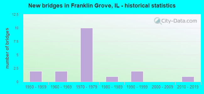
- New bridges - historical statistics
- 21950-1959
- 21960-1969
- 101970-1979
- 11980-1989
- 21990-1999
- 12010-2019


- Bridge Condition - Deck
- 55.6%Good
- 22.2%Satisfactory
- 22.2%Fair

- Bridge Condition - Superstructure
- 11.1%Very good
- 44.4%Good
- 33.3%Satisfactory
- 11.1%Poor

- Bridge Condition - Substructure
- 11.1%Very good
- 77.8%Good
- 11.1%Fair

- Bridge Condition - Channel
- 62.5%Very good
- 25.0%Satisfactory
- 12.5%Fair

- Bridge Condition - Culverts
- 25.0%Very good
- 25.0%Good
- 25.0%Satisfactory
- 25.0%Poor
Find on map >> Show street view
Structure Number: 52002, Location: .6 MI W FRANKLIN GR (Lat: 41.839764, Lng: -89.314806), Route carried "on" structure: State highway 38, Year Built: 1955, Year Reconstructed: 2005, Status: Open, Structure Length: 4.77m (15.65ft), Average Daily Traffic: 2,700 (year 2021), Truck Traffic: 9%, Average Future Daily Traffic: 3,800 (year 2040), Design Load: HS 20, Features Intersected: FRANKLIN CREEK
Minimum Vertical Clearance: 30+ m (98+ ft), Kilometerpoint: 13.277, Lanes on structure: 2, Base Highway Network: Yes, Owner: State Highway Agency, Approaching Roadway Width: 11.0m (36.1ft), Material/Design: Prestressed concrete continuous, Design/Construction: Stringer/Multi-beam, Number Of Spans In Main Unit: 3, Length of Maximum Span: 16.8m (55.1ft), Curb-To-Curb Width: 11.0m (36.1ft), Out-to-Out Width: 12.0m (39.4ft)
Condition: Deck: Satisfactory, Superstructure: Very good, Substructure: Good, Channel: Very good, Operating Rating: 88.1 metric tons, Method Used To Determine Operating Rating: Load Factor (LF) rating reported by rating factor (RF) method using MS18 loading, Inventory Rating: 54.8 metric tons, Method Used To Determine Inventory Rating: Load Factor (LF) rating reported by rating factor (RF) method using MS18 loading, Structural Evaluation: Better than present minimum criteria, Deck Geometry: Somewhat better than minimum adequacy, Waterway Adequacy: Superior to present desirable criteria, Approach Roadway Alignment: Equal to present desirable criteria, Designated Inspection Frequency: Every 48 months, Inspection Date: November 2018, Deck Structure Type: Concrete Cast-file-Place, Wearing Surface/Protective System: Deck Protection: Epoxy Coated Reinforcing
Find on map >> Show street view
Structure Number: 521129, Location: .11MI E DAYSVILLE RD (Lat: 41.844669, Lng: -89.301431), Route carried "on" structure: State highway 38, Year Built: 2018, Status: Open, Structure Length: 0.69m (2.26ft), Average Daily Traffic: 2,750 (year 2021), Truck Traffic: 8%, Average Future Daily Traffic: 3,600 (year 2040), Features Intersected: DRAINAGE DITCH
Minimum Vertical Clearance: 30+ m (98+ ft), Kilometerpoint: 14.564, Lanes on structure: 2, Base Highway Network: Yes, Owner: State Highway Agency, Approaching Roadway Width: 12.2m (40.0ft), Skew: 4 degrees, Material/Design: Concrete, Design/Construction: Culvert, Length of Maximum Span: 3.2m (10.5ft), Curb or Sidewalk Widths: Left: 0.0m, Right: 1.5m (4.9ft)
Condition: Channel: Very good, Culverts: Very good, Operating Rating: 87.2 metric tons, Method Used To Determine Operating Rating: Load and Resistance Factor Rating (LRFR) rating reported by rating factor(RF) method using HL-93 loadings, Inventory Rating: 67.7 metric tons, Method Used To Determine Inventory Rating: Load and Resistance Factor Rating (LRFR) rating reported by rating factor(RF) method using HL-93 loadings, Structural Evaluation: Equal to present desirable criteria, Waterway Adequacy: Equal to present desirable criteria, Approach Roadway Alignment: Equal to present desirable criteria, Designated Inspection Frequency: Every 48 months, Inspection Date: October 2021
Find on map >> Show street view
Structure Number: 522023, Location: 4 MI. W. FRANKLIN GR (Lat: 41.837572, Lng: -89.368664), Route carried "on" structure: State highway 38, Year Built: 1994, Status: Open, Structure Length: 0.79m (2.59ft), Average Daily Traffic: 2,800 (year 2021), Truck Traffic: 8%, Average Future Daily Traffic: 3,500 (year 2040), Design Load: HS 20, Features Intersected: CHAMBERLIN CREEK
Minimum Vertical Clearance: 30+ m (98+ ft), Kilometerpoint: 8.755, Lanes on structure: 2, Base Highway Network: Yes, Owner: State Highway Agency, Approaching Roadway Width: 9.1m (29.9ft), Material/Design: Concrete, Design/Construction: Culvert, Number Of Spans In Main Unit: 2, Length of Maximum Span: 3.8m (12.5ft)
Condition: Channel: Satisfactory, Culverts: Good, Operating Rating: 61.2 metric tons, Method Used To Determine Operating Rating: Load Factor (LF) rating reported by rating factor (RF) method using MS18 loading, Inventory Rating: 36.9 metric tons, Method Used To Determine Inventory Rating: Load Factor (LF) rating reported by rating factor (RF) method using MS18 loading, Structural Evaluation: Better than present minimum criteria, Waterway Adequacy: Equal to present desirable criteria, Approach Roadway Alignment: Equal to present desirable criteria, Designated Inspection Frequency: Every 48 months, Inspection Date: November 2018
Find on map >> Show street view
Structure Number: 52301, Location: SW EDGE FRANKLIN GRO (Lat: 41.837003, Lng: -89.311636), Route carried "on" structure: County highway , Year Built: 1958, Status: Open, Structure Length: 4.42m (14.50ft), Average Daily Traffic: 600 (year 2017), Truck Traffic: 12%, Average Future Daily Traffic: 800 (year 2040), Design Load: HS 15, Features Intersected: FRANKLIN CREEK, Facility Carried by Structure: FRANKLIN RD
Minimum Vertical Clearance: 30+ m (98+ ft), Kilometerpoint: 1.754, Lanes on structure: 2, Owner: County Highway Agency, Approaching Roadway Width: 11.0m (36.1ft), Material/Design: Concrete, Design/Construction: Tee Beam, Number Of Spans In Main Unit: 3, Length of Maximum Span: 16.8m (55.1ft), Curb or Sidewalk Widths: Left: 0.6m (2.0ft), Right: 0.6m (2.0ft), Curb-To-Curb Width: 7.3m (24.0ft), Out-to-Out Width: 9.2m (30.2ft)
Condition: Deck: Fair, Superstructure: Poor, Substructure: Fair, Channel: Very good, Operating Rating: 48.6 metric tons, Method Used To Determine Operating Rating: Load Factor (LF) rating reported by rating factor (RF) method using MS18 loading, Inventory Rating: 29.2 metric tons, Method Used To Determine Inventory Rating: Load Factor (LF) rating reported by rating factor (RF) method using MS18 loading, Structural Evaluation: Meets minimum limits, Deck Geometry: Meets minimum limits, Waterway Adequacy: Equal to present desirable criteria, Approach Roadway Alignment: Equal to present desirable criteria, Designated Inspection Frequency: Every 24 months, Inspection Date: January 2021, Deck Structure Type: Concrete Cast-file-Place
Find on map >> Show street view
Structure Number: 52416, Location: .8 MI SE FRANKLIN GR (Lat: 41.826511, Lng: -89.297975), Route carried "on" structure: County highway , Year Built: 1999, Status: Open, Structure Length: 1.49m (4.89ft), Average Daily Traffic: 250 (year 2017), Average Future Daily Traffic: 300 (year 2040), Design Load: HS 20, Features Intersected: FRANKLIN CREEK, Facility Carried by Structure: WHITNEY RD
Minimum Vertical Clearance: 30+ m (98+ ft), Kilometerpoint: 0.789, Lanes on structure: 2, Owner: Town or Township Highway Agency, Approaching Roadway Width: 8.5m (27.9ft), Material/Design: Prestressed concrete, Design/Construction: Box Beam or Girders - Multiple, Number Of Spans In Main Unit: 1, Length of Maximum Span: 14.2m (46.6ft), Curb-To-Curb Width: 8.5m (27.9ft), Out-to-Out Width: 8.5m (27.9ft)
Condition: Deck: Good, Superstructure: Good, Substructure: Very good, Channel: Very good, Operating Rating: 44.1 metric tons, Method Used To Determine Operating Rating: Assigned rating based on Load Factor Design (LFD) reported by rating factor (RF) using MS18 loading, Inventory Rating: 32.4 metric tons, Method Used To Determine Inventory Rating: Assigned rating based on Load Factor Design (LFD) reported by rating factor (RF) using MS18 loading, Structural Evaluation: Better than present minimum criteria, Deck Geometry: Equal to present minimum criteria, Waterway Adequacy: Equal to present desirable criteria, Approach Roadway Alignment: Equal to present desirable criteria, Designated Inspection Frequency: Every 48 months, Inspection Date: Febuary 2020, Deck Structure Type: Concrete Precast Panels, Wearing Surface/Protective System: Wearing Surface: Bituminous, Membrane: Built-up, Deck Protection: Other
Find on map >> Show street view
Structure Number: 524446, Location: 2.3 MI W FRANKLIN GR (Lat: 41.854639, Lng: -89.348250), Route carried "on" structure: County highway , Year Built: 1988, Status: Open, Structure Length: 2.18m (7.15ft), Average Daily Traffic: 175 (year 2017), Truck Traffic: 1%, Average Future Daily Traffic: 350 (year 2040), Design Load: HS 20, Features Intersected: FRANKLIN CREEK, Facility Carried by Structure: TR-71 OLD MILL ROA
Minimum Vertical Clearance: 30+ m (98+ ft), Kilometerpoint: 0.274, Lanes on structure: 2, Owner: Town or Township Highway Agency, Approaching Roadway Width: 7.3m (24.0ft), Material/Design: Prestressed concrete, Design/Construction: Box Beam or Girders - Multiple, Number Of Spans In Main Unit: 1, Length of Maximum Span: 21.0m (68.9ft), Curb-To-Curb Width: 7.3m (24.0ft), Out-to-Out Width: 7.3m (24.0ft)
Condition: Deck: Fair, Superstructure: Satisfactory, Substructure: Good, Channel: Very good, Operating Rating: 59.0 metric tons, Method Used To Determine Operating Rating: Load Factor (LF) rating reported by rating factor (RF) method using MS18 loading, Inventory Rating: 35.3 metric tons, Method Used To Determine Inventory Rating: Load Factor (LF) rating reported by rating factor (RF) method using MS18 loading, Structural Evaluation: Equal to present minimum criteria, Deck Geometry: Somewhat better than minimum adequacy, Waterway Adequacy: Equal to present desirable criteria, Approach Roadway Alignment: Equal to present desirable criteria, Designated Inspection Frequency: Every 24 months, Inspection Date: Febuary 2020, Deck Structure Type: Concrete Precast Panels
Find on map >> Show street view
Structure Number: 525005, Location: 0.8 M S FRANKLIN GRO (Lat: 41.827939, Lng: -89.313211), Route carried "on" structure: County highway , Year Built: 1966, Status: Open, Structure Length: 0.67m (2.20ft), Average Daily Traffic: 700 (year 2017), Average Future Daily Traffic: 650 (year 2040), Features Intersected: BR OF FRANKLIN CR, Facility Carried by Structure: FRANKLIN ROAD
Minimum Vertical Clearance: 30+ m (98+ ft), Kilometerpoint: 2.720, Lanes on structure: 2, Owner: County Highway Agency, Approaching Roadway Width: 9.8m (32.2ft), Material/Design: Concrete, Design/Construction: Culvert, Number Of Spans In Main Unit: 2, Length of Maximum Span: 3.0m (9.8ft)
Condition: Channel: Fair, Culverts: Poor, Operating Rating: 32.4 metric tons, Method Used To Determine Operating Rating: Field evaluation and documented engineering judgment, Inventory Rating: 19.4 metric tons, Method Used To Determine Inventory Rating: Field evaluation and documented engineering judgment, Structural Evaluation: Meets minimum limits, Waterway Adequacy: Somewhat better than minimum adequacy, Approach Roadway Alignment: Better than present minimum criteria, Designated Inspection Frequency: Every 24 months, Inspection Date: January 2021
Find on map >> Show street view
Structure Number: 52534, Location: 0.8 MI E WHITNEY RD (Lat: 41.815806, Lng: -89.280422), Route carried "on" structure: County highway , Year Built: 1969, Status: Open, Structure Length: 0.88m (2.89ft), Average Daily Traffic: 25 (year 2020), Average Future Daily Traffic: 25 (year 2040), Features Intersected: FRANKLIN CREEK, Facility Carried by Structure: MCGIRR RD
Minimum Vertical Clearance: 30+ m (98+ ft), Kilometerpoint: 8.352, Lanes on structure: 2, Owner: Town or Township Highway Agency, Approaching Roadway Width: 11.0m (36.1ft), Material/Design: Concrete, Design/Construction: Culvert, Number Of Spans In Main Unit: 3, Length of Maximum Span: 2.7m (8.9ft)
Condition: Channel: Satisfactory, Culverts: Satisfactory, Operating Rating: 36.3 metric tons, Method Used To Determine Operating Rating: Load Factor (LF) rating reported by rating factor (RF) method using MS18 loading, Inventory Rating: 21.7 metric tons, Method Used To Determine Inventory Rating: Load Factor (LF) rating reported by rating factor (RF) method using MS18 loading, Structural Evaluation: Equal to present minimum criteria, Waterway Adequacy: Equal to present desirable criteria, Approach Roadway Alignment: Equal to present desirable criteria, Designated Inspection Frequency: Every 24 months, Inspection Date: Febuary 2020
Find on map >> Show street view
Structure Number: 529929, Location: 1.5 MI SE OF NACHUSA (Lat: 41.822619, Lng: -89.361389), Route carried "on" structure: County highway , Year Built: 1974, Status: Open, Structure Length: 6.74m (22.11ft), Average Daily Traffic: 150 (year 2017), Average Future Daily Traffic: 50 (year 2040), Design Load: HS 20, Features Intersected: I-88, Facility Carried by Structure: TR 118 ROBBINS RD
Minimum Vertical Clearance: 30+ m (98+ ft), Kilometerpoint: 2.430, Lanes on structure: 2, Lanes under structure: 4, Owner: State Toll Authority, Approaching Roadway Width: 9.1m (29.9ft), Material/Design: Prestressed concrete, Design/Construction: Stringer/Multi-beam, Number Of Spans In Main Unit: 4, Length of Maximum Span: 23.8m (78.1ft), Curb-To-Curb Width: 8.1m (26.6ft), Out-to-Out Width: 9.1m (29.9ft)
Condition: Deck: Good, Superstructure: Good, Substructure: Good, Operating Rating: 75.2 metric tons, Method Used To Determine Operating Rating: Load Factor (LF) rating reported by rating factor (RF) method using MS18 loading, Inventory Rating: 45.0 metric tons, Method Used To Determine Inventory Rating: Load Factor (LF) rating reported by rating factor (RF) method using MS18 loading, Structural Evaluation: Better than present minimum criteria, Deck Geometry: Somewhat better than minimum adequacy, Underclear: Equal to present minimum criteria, Approach Roadway Alignment: Equal to present desirable criteria, Designated Inspection Frequency: Every 24 months, Inspection Date: July 2019, Deck Structure Type: Concrete Precast Panels
Find on map >> Show street view
Structure Number: 52993, Location: 2 MI SW FRANKLIN GRV (Lat: 41.822631, Lng: -89.342031), Route carried "on" structure: County highway , Year Built: 1974, Status: Open, Structure Length: 6.68m (21.92ft), Average Daily Traffic: 125 (year 2017), Average Future Daily Traffic: 150 (year 2040), Design Load: HS 20, Features Intersected: I-88, Facility Carried by Structure: TR 132A ROCKYFORD
Minimum Vertical Clearance: 30+ m (98+ ft), Kilometerpoint: 1.625, Lanes on structure: 2, Lanes under structure: 4, Owner: State Toll Authority, Approaching Roadway Width: 9.1m (29.9ft), Material/Design: Prestressed concrete, Design/Construction: Stringer/Multi-beam, Number Of Spans In Main Unit: 4, Length of Maximum Span: 23.8m (78.1ft), Curb-To-Curb Width: 8.1m (26.6ft), Out-to-Out Width: 9.1m (29.9ft)
Condition: Deck: Good, Superstructure: Good, Substructure: Good, Operating Rating: 73.5 metric tons, Method Used To Determine Operating Rating: Load Factor (LF) rating reported by rating factor (RF) method using MS18 loading, Inventory Rating: 44.1 metric tons, Method Used To Determine Inventory Rating: Load Factor (LF) rating reported by rating factor (RF) method using MS18 loading, Structural Evaluation: Better than present minimum criteria, Deck Geometry: Somewhat better than minimum adequacy, Underclear: Somewhat better than minimum adequacy, Approach Roadway Alignment: Equal to present desirable criteria, Designated Inspection Frequency: Every 24 months, Inspection Date: July 2019, Deck Structure Type: Concrete Precast Panels
Find on map >> Show street view
Structure Number: 529931, Location: 1 MI SW FRANKLIN GRV (Lat: 41.822711, Lng: -89.313219), Route carried "on" structure: County highway , Year Built: 1974, Status: Open, Structure Length: 6.68m (21.92ft), Average Daily Traffic: 700 (year 2017), Average Future Daily Traffic: 650 (year 2040), Design Load: HS 20, Features Intersected: I-88, Facility Carried by Structure: FRANKLIN RD
Minimum Vertical Clearance: 30+ m (98+ ft), Kilometerpoint: 3.299, Lanes on structure: 2, Lanes under structure: 4, Owner: State Toll Authority, Approaching Roadway Width: 10.4m (34.1ft), Material/Design: Prestressed concrete, Design/Construction: Stringer/Multi-beam, Number Of Spans In Main Unit: 4, Length of Maximum Span: 2.7m (8.9ft), Curb-To-Curb Width: 9.3m (30.5ft), Out-to-Out Width: 10.3m (33.8ft)
Condition: Deck: Satisfactory, Superstructure: Satisfactory, Substructure: Good, Operating Rating: 68.7 metric tons, Method Used To Determine Operating Rating: Load Factor (LF) rating reported by rating factor (RF) method using MS18 loading, Inventory Rating: 41.1 metric tons, Method Used To Determine Inventory Rating: Load Factor (LF) rating reported by rating factor (RF) method using MS18 loading, Structural Evaluation: Equal to present minimum criteria, Deck Geometry: Equal to present minimum criteria, Underclear: Somewhat better than minimum adequacy, Approach Roadway Alignment: Equal to present desirable criteria, Designated Inspection Frequency: Every 24 months, Inspection Date: July 2020, Deck Structure Type: Concrete Precast Panels
Find on map >> Show street view
Structure Number: 529932, Location: S OF FRANKLIN GROVE (Lat: 41.823269, Lng: -89.296889), Route carried "on" structure: County highway , Year Built: 1974, Status: Open, Structure Length: 6.77m (22.21ft), Average Daily Traffic: 250 (year 2017), Average Future Daily Traffic: 300 (year 2040), Design Load: HS 20, Features Intersected: I-88, Facility Carried by Structure: TR 152 GROVE RD
Minimum Vertical Clearance: 30+ m (98+ ft), Kilometerpoint: 1.062, Lanes on structure: 2, Lanes under structure: 4, Owner: State Toll Authority, Approaching Roadway Width: 8.5m (27.9ft), Material/Design: Prestressed concrete, Design/Construction: Stringer/Multi-beam, Number Of Spans In Main Unit: 4, Length of Maximum Span: 24.1m (79.1ft), Curb-To-Curb Width: 8.1m (26.6ft), Out-to-Out Width: 9.1m (29.9ft)
Condition: Deck: Good, Superstructure: Good, Substructure: Good, Operating Rating: 66.7 metric tons, Method Used To Determine Operating Rating: Load Factor (LF) rating reported by rating factor (RF) method using MS18 loading, Inventory Rating: 39.9 metric tons, Method Used To Determine Inventory Rating: Load Factor (LF) rating reported by rating factor (RF) method using MS18 loading, Structural Evaluation: Better than present minimum criteria, Deck Geometry: Somewhat better than minimum adequacy, Underclear: Equal to present minimum criteria, Approach Roadway Alignment: Equal to present desirable criteria, Designated Inspection Frequency: Every 24 months, Inspection Date: July 2020, Deck Structure Type: Concrete Precast Panels
Find on map >> Show street view
Structure Number: 529933, Location: 1 MI E FRANKLIN GR (Lat: 41.834439, Lng: -89.274969), Route carried "on" structure: County highway , Year Built: 1974, Status: Open, Structure Length: 6.80m (22.31ft), Average Daily Traffic: 425 (year 2017), Truck Traffic: 24%, Average Future Daily Traffic: 600 (year 2040), Design Load: HS 20, Features Intersected: I-88, Facility Carried by Structure: Reynolds Road
Minimum Vertical Clearance: 30+ m (98+ ft), Kilometerpoint: 2.317, Lanes on structure: 2, Lanes under structure: 4, Owner: State Toll Authority, Approaching Roadway Width: 9.1m (29.9ft), Skew: 1 degrees, Material/Design: Prestressed concrete, Design/Construction: Stringer/Multi-beam, Number Of Spans In Main Unit: 4, Length of Maximum Span: 24.4m (80.1ft), Curb-To-Curb Width: 8.1m (26.6ft), Out-to-Out Width: 9.1m (29.9ft)
Condition: Deck: Good, Superstructure: Satisfactory, Substructure: Good, Operating Rating: 64.5 metric tons, Method Used To Determine Operating Rating: Load Factor (LF) rating reported by rating factor (RF) method using MS18 loading, Inventory Rating: 38.9 metric tons, Method Used To Determine Inventory Rating: Load Factor (LF) rating reported by rating factor (RF) method using MS18 loading, Structural Evaluation: Equal to present minimum criteria, Deck Geometry: Somewhat better than minimum adequacy, Underclear: Equal to present minimum criteria, Approach Roadway Alignment: Equal to present desirable criteria, Designated Inspection Frequency: Every 24 months, Inspection Date: July 2020, Deck Structure Type: Concrete Precast Panels
Find on map >> Show street view
Structure Number: 529929, Location: 1.5 MI SE OF NACHUSA (Lat: 41.822619, Lng: -89.361389), Route carried "under" structure: Interstate 88, Year Built: 1974, Structure Length: 0. m, Average Daily Traffic: 12,600 (year 2020), Truck Traffic: 62%, Features Intersected: I-88, Facility Carried by Structure: TR 118 ROBBINS RD
Minimum Vertical Clearance: 5.08m (16.67ft), Kilometerpoint: 96.011, Lanes on structure: 2, Lanes under structure: 4, Material/Design: Prestressed concrete, Design/Construction: Stringer/Multi-beam, Length of Maximum Span: 23.8m (78.1ft)
Find on map >> Show street view
Structure Number: 52993, Location: 2 MI SW FRANKLIN GRV (Lat: 41.822631, Lng: -89.342031), Route carried "under" structure: Interstate 88, Year Built: 1974, Structure Length: 0. m, Average Daily Traffic: 12,600 (year 2020), Truck Traffic: 62%, Features Intersected: I-88, Facility Carried by Structure: TR 132A ROCKYFORD
Minimum Vertical Clearance: 5.00m (16.40ft), Kilometerpoint: 97.604, Lanes on structure: 2, Lanes under structure: 4, Material/Design: Prestressed concrete, Design/Construction: Stringer/Multi-beam, Length of Maximum Span: 23.8m (78.1ft)
Find on map >> Show street view
Structure Number: 529931, Location: 1 MI SW FRANKLIN GRV (Lat: 41.822711, Lng: -89.313219), Route carried "under" structure: Interstate 88, Year Built: 1974, Structure Length: 0. m, Average Daily Traffic: 12,600 (year 2020), Truck Traffic: 62%, Features Intersected: I-88, Facility Carried by Structure: FRANKLIN RD
Minimum Vertical Clearance: 4.95m (16.24ft), Kilometerpoint: 100.002, Lanes on structure: 2, Lanes under structure: 4, Material/Design: Prestressed concrete, Design/Construction: Stringer/Multi-beam, Length of Maximum Span: 2.7m (8.9ft)
Find on map >> Show street view
Structure Number: 529932, Location: S OF FRANKLIN GROVE (Lat: 41.823269, Lng: -89.296889), Route carried "under" structure: Interstate 88, Year Built: 1974, Structure Length: 0. m, Average Daily Traffic: 12,600 (year 2020), Truck Traffic: 62%, Features Intersected: I-88, Facility Carried by Structure: TR 152 GROVE RD
Minimum Vertical Clearance: 5.03m (16.50ft), Kilometerpoint: 101.370, Lanes on structure: 2, Lanes under structure: 4, Material/Design: Prestressed concrete, Design/Construction: Stringer/Multi-beam, Length of Maximum Span: 24.1m (79.1ft)
Find on map >> Show street view
Structure Number: 529933, Location: 1 MI E FRANKLIN GR (Lat: 41.834439, Lng: -89.274969), Route carried "under" structure: Interstate 88, Year Built: 1974, Structure Length: 0. m, Average Daily Traffic: 12,600 (year 2020), Truck Traffic: 62%, Features Intersected: I-88, Facility Carried by Structure: Reynolds Road
Minimum Vertical Clearance: 5.03m (16.50ft), Kilometerpoint: 103.575, Lanes on structure: 2, Lanes under structure: 4, Material/Design: Prestressed concrete, Design/Construction: Stringer/Multi-beam, Length of Maximum Span: 24.4m (80.1ft)