Bridge Statistics for Franklin, Kentucky (KY)
Condition, Traffic, Stress, Structural Evaluation, Project Costs
- National Bridge Inventory (NBI) Statistics
- 35Number of bridges
- 374ft / 114mTotal length
- $2,456,000Total costs
- 385,056Total average daily traffic
- 101,056Total average daily truck traffic
- National Bridge Inventory (NBI) Registered Bridges for Franklin
- No street view available for this location
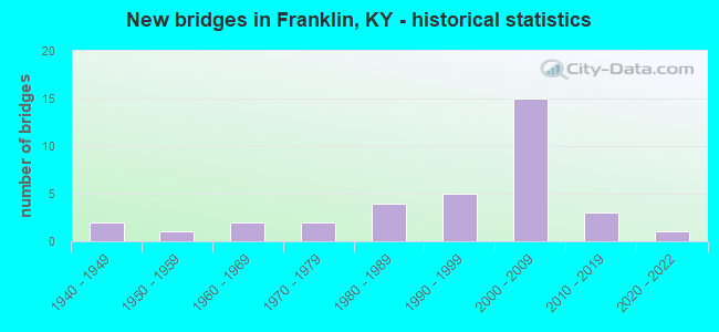
- New bridges - historical statistics
- 21940-1949
- 11950-1959
- 21960-1969
- 21970-1979
- 41980-1989
- 51990-1999
- 152000-2009
- 32010-2019
- 12020-2022


- Bridge Condition - Deck
- 9.1%Very good
- 27.3%Good
- 50.0%Satisfactory
- 13.6%Fair

- Bridge Condition - Superstructure
- 18.2%Very good
- 31.8%Good
- 40.9%Satisfactory
- 9.1%Fair

- Bridge Condition - Substructure
- 4.5%Very good
- 45.5%Good
- 36.4%Satisfactory
- 13.6%Fair

- Bridge Condition - Channel
- 10.0%Very good
- 50.0%Good
- 40.0%Satisfactory

- Bridge Condition - Culverts
- 57.1%Good
- 42.9%Satisfactory
Find on map >> Show street view
Structure Number: 107B00001N, Location: 1 MI S OF WARREN CO LINE (Lat: 36.812222, Lng: -86.556111), Route carried "on" structure: US 31, Year Built: 1941, Status: Open, Structure Length: 0.85m (2.79ft), Average Daily Traffic: 7,789 (year 2018), Truck Traffic: 13%, Average Future Daily Traffic: 6,854 (year 2038), Design Load: H 15, Features Intersected: SINKING CREEK
Minimum Vertical Clearance: 30+ m (98+ ft), Kilometerpoint: 20.794, Lanes on structure: 2, Owner: State Highway Agency, Approaching Roadway Width: 7.6m (24.9ft), Material/Design: Concrete, Design/Construction: Culvert, Number Of Spans In Main Unit: 3, Length of Maximum Span: 2.4m (7.9ft)
Condition: Channel: Good, Culverts: Satisfactory, Inventory Rating: 79.7 metric tons, Method Used To Determine Inventory Rating: Load Factor (LF), Structural Evaluation: Equal to present minimum criteria, Waterway Adequacy: Equal to present desirable criteria, Approach Roadway Alignment: Equal to present desirable criteria, Designated Inspection Frequency: Every 24 months, Inspection Date: July 2021
Find on map >> Show street view
Structure Number: 107B00005N, Location: .15 MI N OF JCT W/KY 100 (Lat: 36.718611, Lng: -86.545556), Route carried "on" structure: State highway 73, Year Built: 1954, Status: Open, Structure Length: 6.43m (21.10ft), Average Daily Traffic: 2,681 (year 2020), Truck Traffic: 9%, Average Future Daily Traffic: 2,359 (year 2040), Design Load: H 20, Features Intersected: W FK DRAKES CREEK
Minimum Vertical Clearance: 30+ m (98+ ft), Kilometerpoint: 11.887, Lanes on structure: 2, Owner: State Highway Agency, Approaching Roadway Width: 8.1m (26.6ft), Material/Design: Concrete, Design/Construction: Tee Beam, Number Of Spans In Main Unit: 4, Length of Maximum Span: 15.2m (49.9ft), Curb or Sidewalk Widths: Left: 0.3m (1.0ft), Right: 0.3m (1.0ft), Curb-To-Curb Width: 7.9m (25.9ft), Out-to-Out Width: 8.5m (27.9ft)
Condition: Deck: Satisfactory, Superstructure: Satisfactory, Substructure: Fair, Channel: Good, Operating Rating: 55.2 metric tons, Method Used To Determine Operating Rating: Load Factor (LF), Inventory Rating: 33.1 metric tons, Method Used To Determine Inventory Rating: Load Factor (LF), Structural Evaluation: Somewhat better than minimum adequacy, Deck Geometry: High priority of corrective action, Waterway Adequacy: Superior to present desirable criteria, Approach Roadway Alignment: Equal to present desirable criteria, Length Of Structure Improvement: 0.65m (2.13ft), Designated Inspection Frequency: Every 24 months, Underwater Inspection Frequency: Every 60 months, Inspection Date: July 2021, Underwater Inspection Date: April 2021, Bridge Improvement Cost: $742,000, Total Project Cost: $742,000, Deck Structure Type: Concrete Cast-file-Place, Wearing Surface/Protective System: Wearing Surface: Latex Concrete
Find on map >> Show street view
Structure Number: 107B00025N, Location: 1 MI N OF JCT KY 1788 (Lat: 36.756667, Lng: -86.544722), Route carried "on" structure: State highway 1171, Year Built: 1973, Status: Open, Structure Length: 6.22m (20.41ft), Average Daily Traffic: 554 (year 2019), Average Future Daily Traffic: 487 (year 2039), Design Load: H 20, Features Intersected: WEST FORK DRAKES CREEK
Minimum Vertical Clearance: 30+ m (98+ ft), Kilometerpoint: 5.189, Lanes on structure: 2, Owner: State Highway Agency, Approaching Roadway Width: 7.3m (24.0ft), Material/Design: Prestressed concrete continuous, Design/Construction: Stringer/Multi-beam, Number Of Spans In Main Unit: 4, Length of Maximum Span: 17.7m (58.1ft), Curb-To-Curb Width: 8.5m (27.9ft), Out-to-Out Width: 9.0m (29.5ft)
Condition: Deck: Fair, Superstructure: Satisfactory, Substructure: Fair, Channel: Satisfactory, Operating Rating: 77.6 metric tons, Method Used To Determine Operating Rating: Load Factor (LF), Inventory Rating: 46.5 metric tons, Method Used To Determine Inventory Rating: Load Factor (LF), Structural Evaluation: Somewhat better than minimum adequacy, Deck Geometry: Somewhat better than minimum adequacy, Waterway Adequacy: Equal to present desirable criteria, Approach Roadway Alignment: Equal to present desirable criteria, Designated Inspection Frequency: Every 24 months, Underwater Inspection Frequency: Every 60 months, Inspection Date: July 2021, Underwater Inspection Date: June 2021, Deck Structure Type: Concrete Cast-file-Place, Wearing Surface/Protective System: Wearing Surface: Integral Concrete
Find on map >> Show street view
Structure Number: 107B00027N, Location: .10 MI SOU. OF JCT KY 100 (Lat: 36.721944, Lng: -86.595833), Route carried "on" structure: State highway 1008, Year Built: 1963, Status: Open, Structure Length: 0.70m (2.30ft), Average Daily Traffic: 1,898 (year 2020), Truck Traffic: 15%, Average Future Daily Traffic: 1,765 (year 2040), Design Load: H 20, Features Intersected: UNNAMED STREAM
Minimum Vertical Clearance: 30+ m (98+ ft), Kilometerpoint: 0.219, Lanes on structure: 2, Owner: State Highway Agency, Approaching Roadway Width: 7.8m (25.6ft), Skew: 4 degrees, Material/Design: Concrete, Design/Construction: Culvert, Number Of Spans In Main Unit: 1, Length of Maximum Span: 4.9m (16.1ft)
Condition: Channel: Good, Culverts: Good, Operating Rating: 54.4 metric tons, Method Used To Determine Operating Rating: Field evaluation and documented engineering judgment, Inventory Rating: 40.8 metric tons, Method Used To Determine Inventory Rating: Field evaluation and documented engineering judgment, Structural Evaluation: Better than present minimum criteria, Waterway Adequacy: Better than present minimum criteria, Approach Roadway Alignment: Equal to present desirable criteria, Designated Inspection Frequency: Every 24 months, Inspection Date: July 2021
Find on map >> Show street view
Structure Number: 107B00028N, Location: .20 MI EAST OF JCT US 31W (Lat: 36.706944, Lng: -86.569722), Route carried "on" structure: State highway 1008, Year Built: 1969, Status: Open, Structure Length: 4.51m (14.80ft), Average Daily Traffic: 9,890 (year 2019), Truck Traffic: 19%, Average Future Daily Traffic: 9,197 (year 2039), Design Load: H 15, Features Intersected: SEABOARD RAILROAD
Minimum Vertical Clearance: 30+ m (98+ ft), Kilometerpoint: 4.170, Lanes on structure: 2, Owner: State Highway Agency, Approaching Roadway Width: 8.5m (27.9ft), Material/Design: Steel continuous, Design/Construction: Stringer/Multi-beam, Number Of Spans In Main Unit: 3, Length of Maximum Span: 17.7m (58.1ft), Curb or Sidewalk Widths: Left: 0.5m (1.6ft), Right: 0.5m (1.6ft), Curb-To-Curb Width: 10.4m (34.1ft), Out-to-Out Width: 11.3m (37.1ft)
Condition: Deck: Fair, Superstructure: Satisfactory, Substructure: Satisfactory, Operating Rating: 60.3 metric tons, Method Used To Determine Operating Rating: Load Factor (LF), Inventory Rating: 36.2 metric tons, Method Used To Determine Inventory Rating: Load Factor (LF), Structural Evaluation: Equal to present minimum criteria, Deck Geometry: Meets minimum limits, Underclear: Better than present minimum criteria, Approach Roadway Alignment: Better than present minimum criteria, Designated Inspection Frequency: Every 24 months, Inspection Date: July 2021, Deck Structure Type: Concrete Cast-file-Place, Wearing Surface/Protective System: Wearing Surface: Low Slump Concrete
Find on map >> Show street view
Structure Number: 107B00030N, Location: 1.1 MI E. OF I-65 OP (Lat: 36.739444, Lng: -86.486944), Route carried "on" structure: State highway 585, Year Built: 1978, Status: Open, Structure Length: 1.46m (4.79ft), Average Daily Traffic: 949 (year 2020), Average Future Daily Traffic: 835 (year 2040), Design Load: HS 20, Features Intersected: LICK FORK CREEK
Minimum Vertical Clearance: 30+ m (98+ ft), Kilometerpoint: 5.842, Lanes on structure: 2, Owner: State Highway Agency, Approaching Roadway Width: 6.4m (21.0ft), Material/Design: Prestressed concrete, Design/Construction: Box Beam or Girders - Multiple, Number Of Spans In Main Unit: 1, Length of Maximum Span: 13.7m (44.9ft), Curb-To-Curb Width: 6.9m (22.6ft), Out-to-Out Width: 7.5m (24.6ft)
Condition: Deck: Satisfactory, Superstructure: Fair, Substructure: Fair, Channel: Satisfactory, Operating Rating: 95.2 metric tons, Method Used To Determine Operating Rating: Load Factor (LF), Inventory Rating: 57.2 metric tons, Method Used To Determine Inventory Rating: Load Factor (LF), Structural Evaluation: Somewhat better than minimum adequacy, Deck Geometry: Meets minimum limits, Waterway Adequacy: Somewhat better than minimum adequacy, Approach Roadway Alignment: Somewhat better than minimum adequacy, Designated Inspection Frequency: Every 24 months, Inspection Date: July 2021, Deck Structure Type: Concrete Precast Panels, Wearing Surface/Protective System: Wearing Surface: Bituminous
Find on map >> Show street view
Structure Number: 107B00033N, Location: 1.2 MI. W. -JCT. KY 383 (Lat: 36.709722, Lng: -86.651667), Route carried "on" structure: State highway 664, Year Built: 1940, Status: Posted for load, Structure Length: 1.25m (4.10ft), Average Daily Traffic: 753 (year 2020), Average Future Daily Traffic: 662 (year 2040), Features Intersected: NEELEY BRANCH
Minimum Vertical Clearance: 30+ m (98+ ft), Kilometerpoint: 9.828, Lanes on structure: 2, Owner: State Highway Agency, Approaching Roadway Width: 7.0m (23.0ft), Material/Design: Steel, Design/Construction: Culvert, Number Of Spans In Main Unit: 2, Length of Maximum Span: 5.8m (19.0ft), Curb-To-Curb Width: 7.2m (23.6ft), Out-to-Out Width: 7.2m (23.6ft)
Condition: Channel: Satisfactory, Culverts: Satisfactory, Operating Rating: 2.7 metric tons, Method Used To Determine Operating Rating: Field evaluation and documented engineering judgment, Inventory Rating: 2.7 metric tons, Method Used To Determine Inventory Rating: Field evaluation and documented engineering judgment, Structural Evaluation: High priority of corrective action, Deck Geometry: Meets minimum limits, Waterway Adequacy: Better than present minimum criteria, Approach Roadway Alignment: Equal to present desirable criteria, Bridge Posting: Required (Relationship of Operating Rating to Maximum Legal Load: > 39.9% below), Designated Inspection Frequency: Every 12 months, Inspection Date: July 2021
Find on map >> Show street view
Structure Number: 107B00034N, Location: 1.7 MI E OF JCT US 31W (Lat: 36.774167, Lng: -86.541667), Route carried "on" structure: State highway 1434, Year Built: 1982, Status: Open, Structure Length: 7.68m (25.20ft), Average Daily Traffic: 253 (year 2020), Average Future Daily Traffic: 222 (year 2040), Design Load: HS 20, Features Intersected: W FK DRAKES CREEK
Minimum Vertical Clearance: 30+ m (98+ ft), Kilometerpoint: 2.778, Lanes on structure: 2, Owner: State Highway Agency, Approaching Roadway Width: 7.2m (23.6ft), Material/Design: Prestressed concrete, Design/Construction: Box Beam or Girders - Multiple, Number Of Spans In Main Unit: 3, Length of Maximum Span: 30.5m (100.1ft), Curb-To-Curb Width: 6.9m (22.6ft), Out-to-Out Width: 7.3m (24.0ft)
Condition: Deck: Good, Superstructure: Fair, Substructure: Satisfactory, Channel: Good, Operating Rating: 77.2 metric tons, Method Used To Determine Operating Rating: Load Factor (LF), Inventory Rating: 46.4 metric tons, Method Used To Determine Inventory Rating: Load Factor (LF), Structural Evaluation: Somewhat better than minimum adequacy, Deck Geometry: Meets minimum limits, Waterway Adequacy: Better than present minimum criteria, Approach Roadway Alignment: Equal to present desirable criteria, Designated Inspection Frequency: Every 24 months, Inspection Date: July 2021, Deck Structure Type: Concrete Precast Panels, Wearing Surface/Protective System: Wearing Surface: Bituminous, Membrane: Preformed Fabric
Find on map >> Show street view
Structure Number: 107B00035N, Location: 0.5 MI.EAST -JCT 31W (Lat: 36.718056, Lng: -86.574444), Route carried "on" structure: State highway 100, Year Built: 1984, Status: Open, Structure Length: 5.18m (16.99ft), Average Daily Traffic: 3,803 (year 2019), Truck Traffic: 6%, Average Future Daily Traffic: 3,536 (year 2039), Design Load: HS 20, Features Intersected: CSX R.R. & R.R ST
Minimum Vertical Clearance: 30+ m (98+ ft), Kilometerpoint: 16.053, Lanes on structure: 4, Lanes under structure: 1, Owner: State Highway Agency, Approaching Roadway Width: 23.2m (76.1ft), Skew: 21 degrees, Material/Design: Prestressed concrete continuous, Design/Construction: Box Beam or Girders - Single/Spread, Number Of Spans In Main Unit: 2, Length of Maximum Span: 29.0m (95.1ft), Curb or Sidewalk Widths: Left: 0.5m (1.6ft), Right: 0.5m (1.6ft), Curb-To-Curb Width: 23.2m (76.1ft), Out-to-Out Width: 24.1m (79.1ft)
Condition: Deck: Satisfactory, Superstructure: Satisfactory, Substructure: Satisfactory, Operating Rating: 79.6 metric tons, Method Used To Determine Operating Rating: Load Factor (LF), Inventory Rating: 47.7 metric tons, Method Used To Determine Inventory Rating: Load Factor (LF), Structural Evaluation: Equal to present minimum criteria, Deck Geometry: Superior to present desirable criteria, Underclear: Somewhat better than minimum adequacy, Approach Roadway Alignment: Equal to present desirable criteria, Length Of Structure Improvement: 0.53m (1.74ft), Designated Inspection Frequency: Every 24 months, Inspection Date: July 2021, Bridge Improvement Cost: $1,715,000, Total Project Cost: $1,714,000, Deck Structure Type: Other, Wearing Surface/Protective System: Wearing Surface: Monolithic Concrete
Find on map >> Show street view
Structure Number: 107B00036N, Location: 1.9 MI E US 31W (Lat: 36.717500, Lng: -86.545278), Route carried "on" structure: State highway 100, Year Built: 1990, Status: Open, Structure Length: 7.47m (24.51ft), Average Daily Traffic: 9,803 (year 2018), Truck Traffic: 8%, Average Future Daily Traffic: 8,136 (year 2038), Design Load: HS 25 or greater, Features Intersected: WEST FK-DRAKES CREEK
Minimum Vertical Clearance: 30+ m (98+ ft), Kilometerpoint: 18.704, Lanes on structure: 2, Base Highway Network: Yes, Owner: State Highway Agency, Approaching Roadway Width: 15.5m (50.9ft), Skew: 1 degrees, Material/Design: Prestressed concrete continuous, Design/Construction: Stringer/Multi-beam, Number Of Spans In Main Unit: 3, Length of Maximum Span: 30.5m (100.1ft), Curb-To-Curb Width: 13.4m (44.0ft), Out-to-Out Width: 14.5m (47.6ft)
Condition: Deck: Satisfactory, Superstructure: Satisfactory, Substructure: Good, Channel: Satisfactory, Operating Rating: 74.9 metric tons, Method Used To Determine Operating Rating: Load Factor (LF), Inventory Rating: 45.0 metric tons, Method Used To Determine Inventory Rating: Load Factor (LF), Structural Evaluation: Equal to present minimum criteria, Deck Geometry: Equal to present minimum criteria, Waterway Adequacy: Better than present minimum criteria, Approach Roadway Alignment: Equal to present desirable criteria, Designated Inspection Frequency: Every 24 months, Underwater Inspection Frequency: Every 60 months, Inspection Date: July 2021, Underwater Inspection Date: April 2021, Deck Structure Type: Concrete Cast-file-Place, Wearing Surface/Protective System: Wearing Surface: Monolithic Concrete
Find on map >> Show street view
Structure Number: 107B00037N, Location: .16 MI N. JCT W105 31W (Lat: 36.739444, Lng: -86.585556), Route carried "on" structure: State highway 73, Year Built: 1994, Status: Posted for load, Structure Length: 0.88m (2.89ft), Average Daily Traffic: 2,915 (year 2017), Truck Traffic: 4%, Average Future Daily Traffic: 2,710 (year 2037), Design Load: HS 20, Features Intersected: UNNAMED STREAM
Minimum Vertical Clearance: 30+ m (98+ ft), Kilometerpoint: 16.081, Lanes on structure: 2, Owner: State Highway Agency, Approaching Roadway Width: 7.0m (23.0ft), Material/Design: Aluminum, Iron, Design/Construction: Culvert, Number Of Spans In Main Unit: 2, Length of Maximum Span: 4.3m (14.1ft)
Condition: Channel: Satisfactory, Culverts: Satisfactory, Operating Rating: 39.9 metric tons, Method Used To Determine Operating Rating: Load Factor (LF), Inventory Rating: 30.7 metric tons, Method Used To Determine Inventory Rating: Load Factor (LF), Structural Evaluation: Equal to present minimum criteria, Waterway Adequacy: Equal to present desirable criteria, Approach Roadway Alignment: Equal to present desirable criteria, Bridge Posting: Required (Relationship of Operating Rating to Maximum Legal Load: > 39.9% below), Designated Inspection Frequency: Every 24 months, Inspection Date: July 2021
Find on map >> Show street view
Structure Number: 107B00040N, Location: 0.40 MI E OF U.S. 31W (Lat: 36.749167, Lng: -86.571389), Route carried "on" structure: State highway 1008, Year Built: 2001, Status: Open, Structure Length: 5.27m (17.29ft), Average Daily Traffic: 4,224 (year 2018), Truck Traffic: 17%, Average Future Daily Traffic: 3,928 (year 2038), Design Load: HS 25 or greater, Features Intersected: SEABOARD RAILROAD
Minimum Vertical Clearance: 30+ m (98+ ft), Kilometerpoint: 9.862, Lanes on structure: 2, Owner: State Highway Agency, Approaching Roadway Width: 13.4m (44.0ft), Material/Design: Prestressed concrete continuous, Design/Construction: Stringer/Multi-beam, Number Of Spans In Main Unit: 3, Length of Maximum Span: 19.5m (64.0ft), Curb-To-Curb Width: 13.4m (44.0ft), Out-to-Out Width: 14.3m (46.9ft)
Condition: Deck: Satisfactory, Superstructure: Good, Substructure: Good, Operating Rating: 80.6 metric tons, Method Used To Determine Operating Rating: Load Factor (LF), Inventory Rating: 48.4 metric tons, Method Used To Determine Inventory Rating: Load Factor (LF), Structural Evaluation: Better than present minimum criteria, Deck Geometry: Better than present minimum criteria, Underclear: Superior to present desirable criteria, Approach Roadway Alignment: Equal to present desirable criteria, Designated Inspection Frequency: Every 24 months, Inspection Date: July 2021, Deck Structure Type: Concrete Cast-file-Place, Wearing Surface/Protective System: Wearing Surface: Monolithic Concrete, Deck Protection: Epoxy Coated Reinforcing
Find on map >> Show street view
Structure Number: 107B00041N, Location: 2.02 MI N OF JCT US 31W (Lat: 36.752622, Lng: -86.597881), Route carried "on" structure: State highway 73, Year Built: 2003, Status: Open, Structure Length: 2.65m (8.69ft), Average Daily Traffic: 1,645 (year 2019), Truck Traffic: 9%, Average Future Daily Traffic: 1,447 (year 2039), Design Load: HS 25 or greater, Features Intersected: SINKING CREEK
Minimum Vertical Clearance: 30+ m (98+ ft), Kilometerpoint: 17.943, Lanes on structure: 2, Owner: State Highway Agency, Approaching Roadway Width: 8.5m (27.9ft), Skew: 3 degrees, Material/Design: Prestressed concrete, Design/Construction: Stringer/Multi-beam, Number Of Spans In Main Unit: 1, Length of Maximum Span: 25.6m (84.0ft), Curb-To-Curb Width: 12.2m (40.0ft), Out-to-Out Width: 13.1m (43.0ft)
Condition: Deck: Good, Superstructure: Good, Substructure: Good, Channel: Good, Operating Rating: 89.8 metric tons, Method Used To Determine Operating Rating: Load Factor (LF), Inventory Rating: 53.7 metric tons, Method Used To Determine Inventory Rating: Load Factor (LF), Structural Evaluation: Better than present minimum criteria, Deck Geometry: Better than present minimum criteria, Waterway Adequacy: Equal to present desirable criteria, Approach Roadway Alignment: Equal to present desirable criteria, Designated Inspection Frequency: Every 24 months, Inspection Date: July 2021, Deck Structure Type: Concrete Cast-file-Place, Wearing Surface/Protective System: Wearing Surface: Monolithic Concrete, Deck Protection: Epoxy Coated Reinforcing
Find on map >> Show street view
Structure Number: 107B00042N, Location: 1.98 MI N OF STATE LINE (Lat: 36.665278, Lng: -86.556111), Route carried "on" structure: Interstate 65, Year Built: 2007, Status: Open, Structure Length: 6.52m (21.39ft), Average Daily Traffic: 43,007 (year 2020), Truck Traffic: 29%, Average Future Daily Traffic: 52,468 (year 2040), Design Load: HS 25 or greater, Features Intersected: U.S. 31W
Minimum Vertical Clearance: 30+ m (98+ ft), Kilometerpoint: 3.269, Lanes on structure: 6, Lanes under structure: 4, Base Highway Network: Yes, Owner: State Highway Agency, Approaching Roadway Width: 18.9m (62.0ft), Skew: 33 degrees, Material/Design: Prestressed concrete continuous, Design/Construction: Stringer/Multi-beam, Number Of Spans In Main Unit: 3, Length of Maximum Span: 39.3m (128.9ft), Curb-To-Curb Width: 18.9m (62.0ft), Out-to-Out Width: 39.7m (130.2ft)
Condition: Deck: Satisfactory, Superstructure: Good, Substructure: Good, Operating Rating: 63.7 metric tons, Method Used To Determine Operating Rating: Load Factor (LF), Inventory Rating: 38.2 metric tons, Method Used To Determine Inventory Rating: Load Factor (LF), Structural Evaluation: Better than present minimum criteria, Deck Geometry: High priority of replacement, Underclear: High priority of corrective action, Approach Roadway Alignment: Equal to present desirable criteria, Designated Inspection Frequency: Every 24 months, Inspection Date: July 2021, Deck Structure Type: Concrete Cast-file-Place, Wearing Surface/Protective System: Wearing Surface: Monolithic Concrete, Deck Protection: Epoxy Coated Reinforcing
Find on map >> Show street view
Structure Number: 107B00043N, Location: 2.48 MI N OF STATE LINE (Lat: 36.671389, Lng: -86.551111), Route carried "on" structure: Interstate 65, Year Built: 2007, Status: Open, Structure Length: 6.00m (19.69ft), Average Daily Traffic: 43,007 (year 2020), Truck Traffic: 29%, Average Future Daily Traffic: 52,468 (year 2040), Design Load: HS 25 or greater, Features Intersected: CSX RAILROAD
Minimum Vertical Clearance: 30+ m (98+ ft), Kilometerpoint: 4.076, Lanes on structure: 6, Base Highway Network: Yes, Owner: State Highway Agency, Approaching Roadway Width: 18.9m (62.0ft), Skew: 33 degrees, Material/Design: Prestressed concrete continuous, Design/Construction: Box Beam or Girders - Single/Spread, Number Of Spans In Main Unit: 3, Length of Maximum Span: 23.8m (78.1ft), Curb-To-Curb Width: 18.9m (62.0ft), Out-to-Out Width: 43.1m (141.4ft)
Condition: Deck: Good, Superstructure: Good, Substructure: Satisfactory, Operating Rating: 93.6 metric tons, Method Used To Determine Operating Rating: Load Factor (LF), Inventory Rating: 56.2 metric tons, Method Used To Determine Inventory Rating: Load Factor (LF), Structural Evaluation: Equal to present minimum criteria, Deck Geometry: High priority of replacement, Underclear: Somewhat better than minimum adequacy, Approach Roadway Alignment: Equal to present desirable criteria, Designated Inspection Frequency: Every 24 months, Inspection Date: July 2021, Deck Structure Type: Concrete Cast-file-Place, Wearing Surface/Protective System: Wearing Surface: Monolithic Concrete, Deck Protection: Epoxy Coated Reinforcing
Find on map >> Show street view
Structure Number: 107B00044N, Location: 3.09 MI N OF STATE LINE (Lat: 36.678611, Lng: -86.545278), Route carried "on" structure: County highway 1137, Year Built: 2007, Status: Open, Structure Length: 7.47m (24.51ft), Average Daily Traffic: 50 (year 2009), Average Future Daily Traffic: 2,029 (year 2029), Design Load: HS 25 or greater, Features Intersected: I-65, Facility Carried by Structure: PEDEN MILL ROAD
Minimum Vertical Clearance: 30+ m (98+ ft), Kilometerpoint: 1.740, Lanes on structure: 2, Lanes under structure: 6, Owner: State Highway Agency, Approaching Roadway Width: 9.8m (32.2ft), Material/Design: Prestressed concrete continuous, Design/Construction: Stringer/Multi-beam, Number Of Spans In Main Unit: 4, Length of Maximum Span: 25.6m (84.0ft), Curb-To-Curb Width: 9.8m (32.2ft), Out-to-Out Width: 10.8m (35.4ft)
Condition: Deck: Good, Superstructure: Very good, Substructure: Good, Operating Rating: 56.7 metric tons, Method Used To Determine Operating Rating: Load Factor (LF), Inventory Rating: 34.0 metric tons, Method Used To Determine Inventory Rating: Load Factor (LF), Structural Evaluation: Better than present minimum criteria, Deck Geometry: Equal to present desirable criteria, Underclear: Equal to present minimum criteria, Approach Roadway Alignment: Equal to present desirable criteria, Designated Inspection Frequency: Every 24 months, Inspection Date: July 2021, Deck Structure Type: Concrete Cast-file-Place, Wearing Surface/Protective System: Wearing Surface: Monolithic Concrete, Deck Protection: Epoxy Coated Reinforcing
Find on map >> Show street view
Structure Number: 107B00045N, Location: 4.33 MILES N. STATE LINE (Lat: 36.694167, Lng: -86.533611), Route carried "on" structure: Interstate 65, Year Built: 2007, Status: Open, Structure Length: 7.59m (24.90ft), Average Daily Traffic: 43,007 (year 2020), Truck Traffic: 29%, Average Future Daily Traffic: 52,468 (year 2040), Design Load: HS 25 or greater, Features Intersected: WEST FORK DRAKES CREEK
Minimum Vertical Clearance: 30+ m (98+ ft), Kilometerpoint: 7.054, Lanes on structure: 6, Base Highway Network: Yes, Owner: State Highway Agency, Approaching Roadway Width: 18.9m (62.0ft), Skew: 33 degrees, Material/Design: Prestressed concrete continuous, Design/Construction: Stringer/Multi-beam, Number Of Spans In Main Unit: 3, Length of Maximum Span: 44.2m (145.0ft), Curb-To-Curb Width: 18.9m (62.0ft), Out-to-Out Width: 41.0m (134.5ft)
Condition: Deck: Satisfactory, Superstructure: Good, Substructure: Good, Channel: Good, Operating Rating: 50.4 metric tons, Method Used To Determine Operating Rating: Load Factor (LF), Inventory Rating: 30.3 metric tons, Method Used To Determine Inventory Rating: Load Factor (LF), Structural Evaluation: Better than present minimum criteria, Deck Geometry: High priority of replacement, Waterway Adequacy: Superior to present desirable criteria, Approach Roadway Alignment: Equal to present desirable criteria, Designated Inspection Frequency: Every 24 months, Inspection Date: July 2021, Deck Structure Type: Concrete Cast-file-Place, Wearing Surface/Protective System: Wearing Surface: Monolithic Concrete, Deck Protection: Epoxy Coated Reinforcing
Find on map >> Show street view
Structure Number: 107B00046N, Location: 4.70 MI N OF STATE LINE (Lat: 36.698889, Lng: -86.531111), Route carried "on" structure: State highway 73, Year Built: 2007, Status: Open, Structure Length: 7.47m (24.51ft), Average Daily Traffic: 778 (year 2018), Truck Traffic: 14%, Average Future Daily Traffic: 684 (year 2038), Design Load: HS 25 or greater, Features Intersected: I-65
Minimum Vertical Clearance: 30+ m (98+ ft), Kilometerpoint: 8.930, Lanes on structure: 2, Lanes under structure: 6, Owner: State Highway Agency, Approaching Roadway Width: 9.8m (32.2ft), Skew: 1 degrees, Material/Design: Prestressed concrete continuous, Design/Construction: Stringer/Multi-beam, Number Of Spans In Main Unit: 4, Length of Maximum Span: 25.6m (84.0ft), Curb-To-Curb Width: 9.8m (32.2ft), Out-to-Out Width: 10.8m (35.4ft)
Condition: Deck: Good, Superstructure: Very good, Substructure: Good, Operating Rating: 58.5 metric tons, Method Used To Determine Operating Rating: Load Factor (LF), Inventory Rating: 35.1 metric tons, Method Used To Determine Inventory Rating: Load Factor (LF), Structural Evaluation: Better than present minimum criteria, Deck Geometry: Equal to present minimum criteria, Underclear: Equal to present minimum criteria, Approach Roadway Alignment: Equal to present desirable criteria, Designated Inspection Frequency: Every 24 months, Inspection Date: July 2021, Deck Structure Type: Concrete Cast-file-Place, Wearing Surface/Protective System: Wearing Surface: Monolithic Concrete, Deck Protection: Epoxy Coated Reinforcing
Find on map >> Show street view
Structure Number: 107B00047N, Location: 5.97 MI N OF STATE LINE (Lat: 36.716111, Lng: -86.521667), Route carried "on" structure: Interstate 65, Year Built: 2008, Status: Open, Structure Length: 8.03m (26.35ft), Average Daily Traffic: 44,332 (year 2020), Truck Traffic: 32%, Average Future Daily Traffic: 54,085 (year 2040), Design Load: HS 25 or greater, Features Intersected: KY 100
Minimum Vertical Clearance: 30+ m (98+ ft), Kilometerpoint: 9.703, Lanes on structure: 6, Lanes under structure: 3, Base Highway Network: Yes, Owner: State Highway Agency, Approaching Roadway Width: 18.9m (62.0ft), Skew: 30 degrees, Material/Design: Steel continuous, Design/Construction: Stringer/Multi-beam, Number Of Spans In Main Unit: 3, Length of Maximum Span: 44.5m (146.0ft), Curb-To-Curb Width: 18.9m (62.0ft), Out-to-Out Width: 39.5m (129.6ft)
Condition: Deck: Satisfactory, Superstructure: Good, Substructure: Good, Operating Rating: 61.2 metric tons, Method Used To Determine Operating Rating: Load Factor (LF), Inventory Rating: 36.7 metric tons, Method Used To Determine Inventory Rating: Load Factor (LF), Structural Evaluation: Better than present minimum criteria, Deck Geometry: High priority of replacement, Underclear: Better than present minimum criteria, Approach Roadway Alignment: Equal to present desirable criteria, Designated Inspection Frequency: Every 24 months, Inspection Date: July 2021, Deck Structure Type: Concrete Cast-file-Place, Wearing Surface/Protective System: Wearing Surface: Monolithic Concrete, Deck Protection: Epoxy Coated Reinforcing
Find on map >> Show street view
Structure Number: 107B00048N, Location: 7.5 MI N OF STATE LINE (Lat: 36.736111, Lng: -86.508333), Route carried "on" structure: State highway 585, Year Built: 2007, Status: Open, Structure Length: 9.14m (29.99ft), Average Daily Traffic: 949 (year 2020), Average Future Daily Traffic: 835 (year 2040), Design Load: HS 25 or greater, Features Intersected: I-65
Minimum Vertical Clearance: 30+ m (98+ ft), Kilometerpoint: 3.745, Lanes on structure: 2, Lanes under structure: 6, Owner: State Highway Agency, Approaching Roadway Width: 9.1m (29.9ft), Skew: 3 degrees, Material/Design: Prestressed concrete continuous, Design/Construction: Stringer/Multi-beam, Number Of Spans In Main Unit: 4, Length of Maximum Span: 29.9m (98.1ft), Curb-To-Curb Width: 9.1m (29.9ft), Out-to-Out Width: 10.1m (33.1ft)
Condition: Deck: Good, Superstructure: Good, Substructure: Good, Operating Rating: 76.8 metric tons, Method Used To Determine Operating Rating: Load Factor (LF), Inventory Rating: 46.1 metric tons, Method Used To Determine Inventory Rating: Load Factor (LF), Structural Evaluation: Better than present minimum criteria, Deck Geometry: Equal to present minimum criteria, Underclear: Equal to present minimum criteria, Approach Roadway Alignment: Equal to present desirable criteria, Designated Inspection Frequency: Every 24 months, Inspection Date: July 2021, Deck Structure Type: Concrete Cast-file-Place, Wearing Surface/Protective System: Wearing Surface: Monolithic Concrete, Deck Protection: Epoxy Coated Reinforcing
Find on map >> Show street view
Structure Number: 107B00051N, Location: 1.4M S OF JCT W/ KY 664 (Lat: 36.697500, Lng: -86.650833), Route carried "on" structure: State highway 383, Year Built: 2011, Status: Posted for load, Structure Length: 1.01m (3.31ft), Average Daily Traffic: 528 (year 2020), Truck Traffic: 14%, Average Future Daily Traffic: 464 (year 2040), Design Load: HS 25 or greater, Features Intersected: NEELY BRANCH
Minimum Vertical Clearance: 30+ m (98+ ft), Kilometerpoint: 7.345, Lanes on structure: 2, Owner: State Highway Agency, Approaching Roadway Width: 7.9m (25.9ft), Skew: 4 degrees, Material/Design: Aluminum, Iron, Design/Construction: Culvert, Number Of Spans In Main Unit: 2, Length of Maximum Span: 3.4m (11.2ft)
Condition: Channel: Good, Culverts: Good, Operating Rating: 53.8 metric tons, Method Used To Determine Operating Rating: Load Factor (LF), Inventory Rating: 32.3 metric tons, Method Used To Determine Inventory Rating: Load Factor (LF), Structural Evaluation: Better than present minimum criteria, Waterway Adequacy: Equal to present minimum criteria, Approach Roadway Alignment: Somewhat better than minimum adequacy, Bridge Posting: Required (Relationship of Operating Rating to Maximum Legal Load: 30.0 - 39.9% below), Designated Inspection Frequency: Every 24 months, Inspection Date: July 2021
Find on map >> Show street view
Structure Number: 107B00053N, Location: 0.5 MI W of KY-622 (Lat: 36.707778, Lng: -86.471667), Route carried "on" structure: State highway 100, Year Built: 2017, Status: Open, Structure Length: 3.35m (10.99ft), Average Daily Traffic: 4,087 (year 2020), Truck Traffic: 8%, Average Future Daily Traffic: 3,596 (year 2040), Design Load: Greater than HL93, Features Intersected: Lick Creek
Minimum Vertical Clearance: 30+ m (98+ ft), Kilometerpoint: 25.487, Lanes on structure: 2, Owner: State Highway Agency, Approaching Roadway Width: 11.9m (39.0ft), Skew: 2 degrees, Material/Design: Prestressed concrete, Design/Construction: Stringer/Multi-beam, Number Of Spans In Main Unit: 1, Length of Maximum Span: 33.5m (109.9ft), Curb-To-Curb Width: 12.2m (40.0ft), Out-to-Out Width: 13.1m (43.0ft)
Condition: Deck: Very good, Superstructure: Very good, Substructure: Good, Channel: Very good, Operating Rating: 94.6 metric tons, Method Used To Determine Operating Rating: Load and Resistance Factor Rating (LRFR) rating reported by rating factor(RF) method using HL-93 loadings, Inventory Rating: 72.9 metric tons, Method Used To Determine Inventory Rating: Load and Resistance Factor Rating (LRFR) rating reported by rating factor(RF) method using HL-93 loadings, Structural Evaluation: Better than present minimum criteria, Deck Geometry: Equal to present minimum criteria, Waterway Adequacy: Equal to present desirable criteria, Approach Roadway Alignment: Equal to present desirable criteria, Designated Inspection Frequency: Every 24 months, Inspection Date: July 2021, Deck Structure Type: Concrete Cast-file-Place, Wearing Surface/Protective System: Wearing Surface: Monolithic Concrete, Deck Protection: Epoxy Coated Reinforcing
Find on map >> Show street view
Structure Number: 107B00054N, Location: 1.6 MI N of Int I-65 (Lat: 36.687139, Lng: -86.568372), Route carried "on" structure: US 31, Year Built: 2017, Status: Open, Structure Length: 0.61m (2.00ft), Average Daily Traffic: 11,623 (year 2020), Truck Traffic: 9%, Average Future Daily Traffic: 9,647 (year 2040), Design Load: Greater than HL93, Features Intersected: Sharps Branch
Minimum Vertical Clearance: 30+ m (98+ ft), Kilometerpoint: 6.416, Lanes on structure: 2, Base Highway Network: Yes, Owner: State Highway Agency, Approaching Roadway Width: 14.2m (46.6ft), Skew: 1 degrees, Material/Design: Concrete, Design/Construction: Culvert, Number Of Spans In Main Unit: 1, Length of Maximum Span: 6.1m (20.0ft), Curb-To-Curb Width: 14.2m (46.6ft), Out-to-Out Width: 39.0m (128.0ft)
Condition: Channel: Good, Culverts: Good, Operating Rating: 55.7 metric tons, Method Used To Determine Operating Rating: Load and Resistance Factor Rating (LRFR) rating reported by rating factor(RF) method using HL-93 loadings, Inventory Rating: 43.1 metric tons, Method Used To Determine Inventory Rating: Load and Resistance Factor Rating (LRFR) rating reported by rating factor(RF) method using HL-93 loadings, Structural Evaluation: Better than present minimum criteria, Deck Geometry: Superior to present desirable criteria, Waterway Adequacy: Equal to present desirable criteria, Approach Roadway Alignment: Superior to present desirable criteria, Designated Inspection Frequency: Every 24 months, Inspection Date: July 2021
Find on map >> Show street view
Structure Number: 107B00055N, Location: 2 MI N OF JCT US 31W (Lat: 36.802500, Lng: -86.581944), Route carried "on" structure: State highway 621, Year Built: 2020, Status: Open, Structure Length: 0.91m (2.99ft), Average Daily Traffic: 523 (year 2020), Average Future Daily Traffic: 460 (year 2040), Design Load: Greater than HL93, Features Intersected: Sinking Creek
Minimum Vertical Clearance: 30+ m (98+ ft), Kilometerpoint: 10.755, Lanes on structure: 2, Owner: State Highway Agency, Approaching Roadway Width: 5.8m (19.0ft), Material/Design: Prestressed concrete, Design/Construction: Box Beam or Girders - Multiple, Number Of Spans In Main Unit: 1, Length of Maximum Span: 8.7m (28.5ft), Curb-To-Curb Width: 6.9m (22.6ft), Out-to-Out Width: 7.3m (24.0ft)
Condition: Deck: Very good, Superstructure: Very good, Substructure: Very good, Channel: Very good, Operating Rating: 66.4 metric tons, Method Used To Determine Operating Rating: Load and Resistance Factor Rating (LRFR) rating reported by rating factor(RF) method using HL-93 loadings, Inventory Rating: 51.2 metric tons, Method Used To Determine Inventory Rating: Load and Resistance Factor Rating (LRFR) rating reported by rating factor(RF) method using HL-93 loadings, Structural Evaluation: Equal to present desirable criteria, Deck Geometry: Meets minimum limits, Waterway Adequacy: Equal to present minimum criteria, Approach Roadway Alignment: Better than present minimum criteria, Designated Inspection Frequency: Every 24 months, Inspection Date: July 2021, Deck Structure Type: Concrete Cast-file-Place, Wearing Surface/Protective System: Wearing Surface: Monolithic Concrete, Deck Protection: Epoxy Coated Reinforcing
Find on map >> Show street view
Structure Number: 107C00009N, Location: 0.14 MI WEST JCT KY 621 (Lat: 36.790556, Lng: -86.585000), Route carried "on" structure: County highway 1315, Year Built: 1984, Status: Open, Structure Length: 1.04m (3.41ft), Average Daily Traffic: 112 (year 2006), Average Future Daily Traffic: 2,026 (year 2026), Features Intersected: SINKING CREEK, Facility Carried by Structure: MARY ADAMS ROAD
Minimum Vertical Clearance: 30+ m (98+ ft), Kilometerpoint: 0.214, Lanes on structure: 1, Owner: County Highway Agency, Approaching Roadway Width: 5.5m (18.0ft), Skew: 1 degrees, Material/Design: Concrete, Design/Construction: Culvert, Number Of Spans In Main Unit: 2, Length of Maximum Span: 4.9m (16.1ft)
Condition: Channel: Satisfactory, Culverts: Good, Operating Rating: 54.4 metric tons, Method Used To Determine Operating Rating: Field evaluation and documented engineering judgment, Inventory Rating: 39.9 metric tons, Method Used To Determine Inventory Rating: Field evaluation and documented engineering judgment, Structural Evaluation: Better than present minimum criteria, Waterway Adequacy: Better than present minimum criteria, Approach Roadway Alignment: Better than present minimum criteria, Designated Inspection Frequency: Every 24 months, Inspection Date: December 2020
Find on map >> Show street view
Structure Number: 107C00013N, Location: .1 MI S KY 383 (Lat: 36.693056, Lng: -86.652778), Route carried "on" structure: County highway 1207, Year Built: 1990, Status: Open, Structure Length: 1.22m (4.00ft), Average Daily Traffic: 27 (year 2006), Average Future Daily Traffic: 2,026 (year 2026), Design Load: HS 25 or greater, Features Intersected: NEELY BRANCH, Facility Carried by Structure: KUMMER ROAD
Minimum Vertical Clearance: 30+ m (98+ ft), Kilometerpoint: 0.098, Lanes on structure: 2, Owner: County Highway Agency, Approaching Roadway Width: 6.1m (20.0ft), Skew: 4 degrees, Material/Design: Prestressed concrete, Design/Construction: Box Beam or Girders - Multiple, Number Of Spans In Main Unit: 1, Length of Maximum Span: 11.3m (37.1ft), Curb-To-Curb Width: 6.1m (20.0ft), Out-to-Out Width: 6.6m (21.7ft)
Condition: Deck: Fair, Superstructure: Satisfactory, Substructure: Satisfactory, Channel: Good, Operating Rating: 69.4 metric tons, Method Used To Determine Operating Rating: Load Factor (LF), Inventory Rating: 41.6 metric tons, Method Used To Determine Inventory Rating: Load Factor (LF), Structural Evaluation: Equal to present minimum criteria, Deck Geometry: Somewhat better than minimum adequacy, Waterway Adequacy: Better than present minimum criteria, Approach Roadway Alignment: Better than present minimum criteria, Designated Inspection Frequency: Every 24 months, Inspection Date: December 2020, Deck Structure Type: Concrete Cast-file-Place, Wearing Surface/Protective System: Wearing Surface: Monolithic Concrete
Find on map >> Show street view
Structure Number: 107C00014N, Location: 1.4 MI S JCT US 31W (Lat: 36.674722, Lng: -86.584444), Route carried "on" structure: County highway 1149, Year Built: 1992, Status: Open, Structure Length: 1.07m (3.51ft), Average Daily Traffic: 54 (year 2006), Average Future Daily Traffic: 2,026 (year 2026), Design Load: HS 25 or greater, Features Intersected: SHARPS BRANCH, Facility Carried by Structure: LAKE SPRING ROAD
Minimum Vertical Clearance: 30+ m (98+ ft), Kilometerpoint: 0.628, Lanes on structure: 2, Owner: County Highway Agency, Approaching Roadway Width: 5.2m (17.1ft), Skew: 1 degrees, Material/Design: Prestressed concrete, Design/Construction: Box Beam or Girders - Multiple, Number Of Spans In Main Unit: 1, Length of Maximum Span: 10.1m (33.1ft), Curb-To-Curb Width: 5.6m (18.4ft), Out-to-Out Width: 6.1m (20.0ft)
Condition: Deck: Satisfactory, Superstructure: Satisfactory, Substructure: Satisfactory, Channel: Good, Operating Rating: 64.5 metric tons, Method Used To Determine Operating Rating: Load Factor (LF), Inventory Rating: 38.6 metric tons, Method Used To Determine Inventory Rating: Load Factor (LF), Structural Evaluation: Equal to present minimum criteria, Deck Geometry: Meets minimum limits, Waterway Adequacy: Equal to present minimum criteria, Approach Roadway Alignment: Better than present minimum criteria, Designated Inspection Frequency: Every 24 months, Inspection Date: December 2020, Deck Structure Type: Concrete Precast Panels, Wearing Surface/Protective System: Wearing Surface: Bituminous
Find on map >> Show street view
Structure Number: 107C00016N, Location: .3 MI S JCT US 31W (Lat: 36.684444, Lng: -86.573333), Route carried "on" structure: County highway 1149, Year Built: 1999, Status: Posted for load, Structure Length: 0.98m (3.22ft), Average Daily Traffic: 83 (year 2006), Average Future Daily Traffic: 2,026 (year 2026), Design Load: HS 20, Features Intersected: SHARPS BRANCH, Facility Carried by Structure: LAKE SPRING ROAD
Minimum Vertical Clearance: 30+ m (98+ ft), Kilometerpoint: 2.160, Lanes on structure: 2, Owner: County Highway Agency, Approaching Roadway Width: 6.1m (20.0ft), Skew: 4 degrees, Material/Design: Wood or Timber, Design/Construction: Slab, Number Of Spans In Main Unit: 1, Length of Maximum Span: 9.1m (29.9ft), Curb-To-Curb Width: 7.3m (24.0ft), Out-to-Out Width: 7.7m (25.3ft)
Condition: Deck: Satisfactory, Superstructure: Satisfactory, Substructure: Satisfactory, Channel: Satisfactory, Operating Rating: 40.8 metric tons, Method Used To Determine Operating Rating: Allowable Stress (AS), Inventory Rating: 26.5 metric tons, Method Used To Determine Inventory Rating: Allowable Stress (AS), Structural Evaluation: Equal to present minimum criteria, Deck Geometry: Equal to present minimum criteria, Waterway Adequacy: Equal to present minimum criteria, Approach Roadway Alignment: Better than present minimum criteria, Bridge Posting: Required (Relationship of Operating Rating to Maximum Legal Load: > 39.9% below), Designated Inspection Frequency: Every 24 months, Inspection Date: December 2020, Deck Structure Type: Wood or Timber, Wearing Surface/Protective System: Wearing Surface: Bituminous
Find on map >> Show street view
Structure Number: 107C00017N, Location: 1.51 MI W JCT. 31W (Lat: 36.779653, Lng: -86.593553), Route carried "on" structure: County highway 1347, Year Built: 2004, Status: Open, Structure Length: 1.28m (4.20ft), Average Daily Traffic: 253 (year 2006), Average Future Daily Traffic: 2,026 (year 2026), Design Load: HS 25 or greater, Features Intersected: SINKING CREEK, Facility Carried by Structure: VANCES MILL ROAD
Minimum Vertical Clearance: 30+ m (98+ ft), Kilometerpoint: 3.064, Lanes on structure: 2, Owner: County Highway Agency, Approaching Roadway Width: 5.0m (16.4ft), Skew: 1 degrees, Material/Design: Prestressed concrete, Design/Construction: Box Beam or Girders - Multiple, Number Of Spans In Main Unit: 1, Length of Maximum Span: 12.2m (40.0ft), Curb-To-Curb Width: 7.0m (23.0ft), Out-to-Out Width: 7.5m (24.6ft)
Condition: Deck: Satisfactory, Superstructure: Satisfactory, Substructure: Satisfactory, Channel: Satisfactory, Operating Rating: 80.1 metric tons, Method Used To Determine Operating Rating: Load Factor (LF), Inventory Rating: 48.1 metric tons, Method Used To Determine Inventory Rating: Load Factor (LF), Structural Evaluation: Equal to present minimum criteria, Deck Geometry: Meets minimum limits, Waterway Adequacy: Equal to present desirable criteria, Approach Roadway Alignment: Equal to present desirable criteria, Designated Inspection Frequency: Every 24 months, Inspection Date: December 2020, Deck Structure Type: Concrete Precast Panels, Wearing Surface/Protective System: Wearing Surface: Monolithic Concrete
Find on map >> Show street view
Structure Number: 107B00035N, Location: 0.5 MI.EAST -JCT 31W (Lat: 36.718056, Lng: -86.574444), Route carried "under" structure: City street 1067, Year Built: 1984, Structure Length: 0. m, Average Daily Traffic: 205 (year 2006), Features Intersected: CSX R.R. & R.R ST, Facility Carried by Structure: KY 100
Minimum Vertical Clearance: 6.10m (20.01ft), Kilometerpoint: 0.412, Lanes on structure: 4, Lanes under structure: 1, Material/Design: Prestressed concrete continuous, Design/Construction: Box Beam or Girders - Single/Spread, Length of Maximum Span: 29.0m (95.1ft)
Find on map >> Show street view
Structure Number: 107B00042N, Location: 1.98 MI N OF STATE LINE (Lat: 36.665278, Lng: -86.556111), Route carried "under" structure: US 31, Year Built: 2007, Structure Length: 0. m, Average Daily Traffic: 10,841 (year 2018), Truck Traffic: 28%, Features Intersected: U.S. 31W, Facility Carried by Structure: I-65
Minimum Vertical Clearance: 30+ m (98+ ft), Kilometerpoint: 3.724, Lanes on structure: 6, Lanes under structure: 4, Material/Design: Prestressed concrete continuous, Design/Construction: Stringer/Multi-beam, Length of Maximum Span: 39.3m (128.9ft)
Find on map >> Show street view
Structure Number: 107B00044N, Location: 3.09 MI N OF STATE LINE (Lat: 36.678611, Lng: -86.545278), Route carried "under" structure: Interstate 65, Year Built: 2007, Structure Length: 0. m, Average Daily Traffic: 43,007 (year 2020), Truck Traffic: 29%, Features Intersected: I-65, Facility Carried by Structure: PEDEN MILL ROAD
Minimum Vertical Clearance: 30+ m (98+ ft), Kilometerpoint: 5.028, Lanes on structure: 2, Lanes under structure: 6, Material/Design: Prestressed concrete continuous, Design/Construction: Stringer/Multi-beam, Length of Maximum Span: 25.6m (84.0ft)
Find on map >> Show street view
Structure Number: 107B00046N, Location: 4.70 MI N OF STATE LINE (Lat: 36.698889, Lng: -86.531111), Route carried "under" structure: Interstate 65, Year Built: 2007, Structure Length: 0. m, Average Daily Traffic: 43,007 (year 2020), Truck Traffic: 29%, Features Intersected: I-65, Facility Carried by Structure: KY 73
Minimum Vertical Clearance: 30+ m (98+ ft), Kilometerpoint: 7.612, Lanes on structure: 2, Lanes under structure: 6, Material/Design: Prestressed concrete continuous, Design/Construction: Stringer/Multi-beam, Length of Maximum Span: 25.6m (84.0ft)
Find on map >> Show street view
Structure Number: 107B00047N, Location: 5.97 MI N OF STATE LINE (Lat: 36.716111, Lng: -86.521667), Route carried "under" structure: State highway 100, Year Built: 2008, Structure Length: 0. m, Average Daily Traffic: 4,087 (year 2020), Truck Traffic: 8%, Features Intersected: KY 100, Facility Carried by Structure: I-65
Minimum Vertical Clearance: 30+ m (98+ ft), Kilometerpoint: 20.851, Lanes on structure: 6, Lanes under structure: 3, Material/Design: Steel continuous, Design/Construction: Stringer/Multi-beam, Length of Maximum Span: 44.5m (146.0ft)
Find on map >> Show street view
Structure Number: 107B00048N, Location: 7.5 MI N OF STATE LINE (Lat: 36.736111, Lng: -86.508333), Route carried "under" structure: Interstate 65, Year Built: 2007, Structure Length: 0. m, Average Daily Traffic: 44,332 (year 2020), Truck Traffic: 32%, Features Intersected: I-65, Facility Carried by Structure: KY 585
Minimum Vertical Clearance: 5.21m (17.09ft), Kilometerpoint: 12.247, Lanes on structure: 2, Lanes under structure: 6, Material/Design: Prestressed concrete continuous, Design/Construction: Stringer/Multi-beam, Length of Maximum Span: 29.9m (98.1ft)